 E-PICS - ETHBIB.Bildarchiv


The images presented on this page are part of E-Pics, a service provided by the ETH-Bibliothek of ETH Zurich. You find here static medium resolution images published under the creative commons
CC-BY-SA license or with the Public Domain Mark. This means that you are free to share, copy and redistribute the material in any medium or format; that you are free to remix, transform, and build upon the material for any purpose, even commercially, under the following conditions: You must give appropriate credit, provide a link to the license, and indicate if changes were made.
- More information about E-Pics is available at https://www.e-pics.ethz.ch
- This catalog can also be accessed at https://ba.e-pics.ethz.ch/ . There you can download the image in a higher resolution.

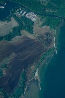
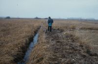
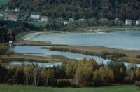
Title (German)
HM 744, Fideriser Heuberge, Faninpass: Kulturlandschaft mit vielgestaltigem Relief
Caption
Coordinates: 774'800, 193'500
Caption (German)
Koordinaten: 774'800, 193'500
Record Name
Dia_358-4834

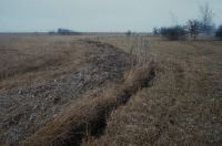
Title (German)
HM 744, Fideriser Heuberge, Drainagegraben/Entwässerung
Caption
Coordinates: 774'800, 193'500
Caption (German)
Koordinaten: 774'800, 193'500
Record Name
Dia_358-4835

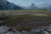
Title (German)
HM 744, Fideriser Heuberge, Faninpass: Streuriet, Nardus-Bestände
Caption
Coordinates: 774'800, 193'500
Caption (German)
Koordinaten: 774'800, 193'500
Record Name
Dia_358-4836

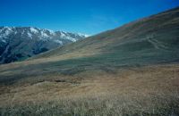
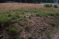
Title (German)
HM 744, Fideriser Heuberge, Erosion durch Viehtritt
Caption
Coordinates: 774'800, 193'500
Caption (German)
Koordinaten: 774'800, 193'500
Record Name
Dia_358-4837

Title (German)
HM 744, Fideriser Heuberge, Erosion durch Viehtritt
Caption
Coordinates: 774'800, 193'500
Caption (German)
Koordinaten: 774'800, 193'500
Record Name
Dia_358-4838

Title (German)
FM 0850, Hänsiried, Ueberbauung am Rand des Moores
Caption
Coordinates: 679'000, 253'600
Caption (German)
Koordinaten: 679'000, 253'600
Record Name
Dia_358-4839

Title (German)
FM 0850, Hänsiried
Caption
Coordinates: 679'000, 253'600
Caption (German)
Koordinaten: 679'000, 253'600
Record Name
Dia_358-4840

Title (German)
FM 0850, Hänsiried
Caption
Coordinates: 679'000, 253'600
Caption (German)
Koordinaten: 679'000, 253'600
Record Name
Dia_358-4841

Title (German)
FM 0873, Salomonstempel
Caption
Coordinates: 729'500, 238'600
Caption (German)
Koordinaten: 729'500, 238'600
Record Name
Dia_358-4842

Title (German)
FM 0873, Salomonstempel
Caption
Coordinates: 729'500, 238'600
Caption (German)
Koordinaten: 729'500, 238'600
Record Name
Dia_358-4843

Title (German)
FM 1141, Sulzel
Caption
Coordinates: 222'600, 703'200
Caption (German)
Koordinaten: 222'600, 703'200
Record Name
Dia_358-4844

Title (German)
FM 1141, Sulzel, Drainagegraben/Entwässerung
Caption
Coordinates: 222'600, 703'200
Caption (German)
Koordinaten: 222'600, 703'200
Record Name
Dia_358-4845

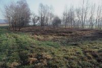
Title (German)
FM 1141, Sulzel, Aushub
Caption
Coordinates: 222'600, 703'200
Caption (German)
Koordinaten: 222'600, 703'200
Record Name
Dia_358-4846

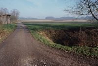
Title (German)
FM 1141, Sulzel, Durchlass Strasse, Drainage/Entwässerung
Caption
Coordinates: 222'600, 703'200
Caption (German)
Koordinaten: 222'600, 703'200
Record Name
Dia_358-4847

Title (German)
FM 1141, Sulzel, Drainage/Entwässerung
Caption
Coordinates: 222'600, 703'200
Caption (German)
Koordinaten: 222'600, 703'200
Record Name
Dia_358-4848

Title (German)
FM 1141, Sulzel, Aushub
Caption
Coordinates: 222'600, 703'200
Caption (German)
Koordinaten: 222'600, 703'200
Record Name
Dia_358-4849

FM 1236, Rieter on the southern shore of Lake Aegeri, Morgartenried between Sidenfaden and Giselmatt
Title (German)
FM 1236, Rieter am Südufer des Aegerisees, Morgartenried zwischen Sidenfaden und Giselmatt
Caption
Coordinates: 690'500, 217'300
Caption (German)
Koordinaten: 690'500, 217'300
Record Name
Dia_358-4850

Title (German)
FM 1236, Rieter am Südufer des Aegerisees, Morgartenried zwischen Sidenfaden und Giselmat
Caption
Coordinates: 690'500, 217'300
Caption (German)
Koordinaten: 690'500, 217'300
Record Name
Dia_358-4851

FM 1236, Rieter on the southern shore of Lake Aegeri, Morgartenried between Sidenfaden and Giselmatt
Title (German)
FM 1236, Rieter am Südufer des Aegerisees, Morgartenried zwischen Sidenfaden und Giselmatt
Caption
Coordinates: 690'500, 217'300
Caption (German)
Koordinaten: 690'500, 217'300
Record Name
Dia_358-4852

Title (German)
FM 1236, Rieter am Südufer des Aegerisees, Morgartenried zwischen Sidenfaden und Giselmatt
Caption
Coordinates: 690'500, 217'300
Caption (German)
Koordinaten: 690'500, 217'300
Record Name
Dia_358-4853

Title (German)
FM 1236, Rieter am Südufer des Aegerisees, Bauprofil am Moorrand
Caption
Coordinates: 690'500, 217'300
Caption (German)
Koordinaten: 690'500, 217'300
Record Name
Dia_358-4854

Title (German)
FM 1236, Rieter am Südufer des Aegerisees, Bauprofil am Moorrand
Caption
Coordinates: 690'500, 217'300
Caption (German)
Koordinaten: 690'500, 217'300
Record Name
Dia_358-4855

Title (German)
FM 1236, Rieter am Südufer des Aegerisees, Giselmatt, Sagen
Caption
Coordinates: 690'500, 217'300
Caption (German)
Koordinaten: 690'500, 217'300
Record Name
Dia_358-4856

Title (German)
FM 1378, La Muraz, remblais et dépôt de matériaux en bordure de marais
Caption
Coordinates: 559'300, 138'200
Caption (German)
Koordinaten: 559'300, 138'200
Record Name
Dia_358-4857

Title (German)
FM 1382 , Gro Brasset, Les Grangettes: überschüttetes Flachmoor
Caption
Coordinates: 557'400, 138'000
Caption (German)
Koordinaten: 557'400, 138'000
Record Name
Dia_358-4858

Title (German)
FM 1382, Gro Brasset, Les Grangettes: Aufschüttung im Norden (N) des Yachthafens
Caption
Coordinates: 557'400, 138'000
Caption (German)
Koordinaten: 557'400, 138'000
Record Name
Dia_358-4859

Title (German)
FM 1382, Gro Brasset, Les Grangettes: vertieftes Hafenbecken
Caption
Coordinates: 557'400, 138'000
Caption (German)
Koordinaten: 557'400, 138'000
Record Name
Dia_358-4860

Title (German)
FM 1382, Gro Brasset, Les Grangettes: vertieftes Hafenbecken
Caption
Coordinates: 557'400, 138'000
Caption (German)
Koordinaten: 557'400, 138'000
Record Name
Dia_358-4861
Title (German)
FM 1382, Gros Brasset, Rhonedelta, Schilf-Brandfläche und überschüttete Fläche
Caption
Coordinates: 557'400, 138'000
Caption (German)
Koordinaten: 557'400, 138'000
Record Name
Dia_358-4862

Title (German)
FM 1382, Gros Brasset, Rhonedelta
Caption
Coordinates: 557'400, 138'000
Caption (German)
Koordinaten: 557'400, 138'000
Record Name
Dia_358-4863

Title (German)
FM 1382, Gros Brasset, Rhonedelta, Pollen-Pappeln
Caption
Coordinates: 557'400, 138'000
Caption (German)
Koordinaten: 557'400, 138'000
Record Name
Dia_358-4864

Title (German)
FM 1668, Stavel da Maighels
Caption
Coordinates: 695'700, 163'400
Caption (German)
Koordinaten: 695'700, 163'400
Record Name
Dia_358-4865

Title (German)
FM 1668, Stavel da Maighels
Caption
Coordinates: 695'700, 163'400
Caption (German)
Koordinaten: 695'700, 163'400
Record Name
Dia_358-4866

Title (German)
FM 1668, Stavel da Maighels, Erosion des Moorkörpers durch mäandrierenden Bach
Caption
Coordinates: 695'700, 163'400
Caption (German)
Koordinaten: 695'700, 163'400
Record Name
Dia_358-4867

Title (German)
FM 1668, Stavel da Maighels, Erosion des Moorkörpers durch mäandrierenden Bach
Caption
Coordinates: 695'700, 163'400
Caption (German)
Koordinaten: 695'700, 163'400
Record Name
Dia_358-4868

Title (German)
FM 1668, Stavel da Maighels, Erosion des Moorkörpers durch mäandrierenden Bach
Caption
Coordinates: 695'700, 163'400
Caption (German)
Koordinaten: 695'700, 163'400
Record Name
Dia_358-4869

Title (German)
FM 1668, Stavel da Maighels, Akkumulation von erodiertem Torf in Hohlformen
Caption
Coordinates: 695'700, 163'400
Caption (German)
Koordinaten: 695'700, 163'400
Record Name
Dia_358-4870

Title (German)
FM 1668, Stavel da Maighels, Erosion des Torfkörpers durch Bach
Caption
Coordinates: 695'700, 163'400
Caption (German)
Koordinaten: 695'700, 163'400
Record Name
Dia_358-4871

Title (German)
FM 1668, Stavel da Maighels, Erosion des Torfkörpers durch Bach
Caption
Coordinates: 695'700, 163'400
Caption (German)
Koordinaten: 695'700, 163'400
Record Name
Dia_358-4872
Title (German)
FM 1668, Stavel da Maighels, Entwässerter Moorsee/Drainage
Caption
Coordinates: 695'700, 163'400
Caption (German)
Koordinaten: 695'700, 163'400
Record Name
Dia_358-4873

Title (German)
FM 1668, Stavel da Maighels, Torferosion, Viehtritt
Caption
Coordinates: 695'700, 163'400
Caption (German)
Koordinaten: 695'700, 163'400
Record Name
Dia_358-4874

Title (German)
FM 1668, Stavel da Maighels, Torferosion, Beweidung
Caption
Coordinates: 695'700, 163'400
Caption (German)
Koordinaten: 695'700, 163'400
Record Name
Dia_358-4875

Title (German)
FM 1668, Stavel da Maighels
Caption
Coordinates: 695'700, 163'400
Caption (German)
Koordinaten: 695'700, 163'400
Record Name
Dia_358-4876

Title (German)
FM 1668, Stavel da Maighels, Bergsee mit Verlandungszone
Caption
Coordinates: 695'700, 163'400
Caption (German)
Koordinaten: 695'700, 163'400
Record Name
Dia_358-4877

Title (German)
FM 1668, Stavel da Maighels, Erosion des Torfes infolge Viehtritt
Caption
Coordinates: 695'700, 163'400
Caption (German)
Koordinaten: 695'700, 163'400
Record Name
Dia_358-4878

Title (German)
FM 1668, Stavel da Maighels, Torferosion
Caption
Coordinates: 695'700, 163'400
Caption (German)
Koordinaten: 695'700, 163'400
Record Name
Dia_358-4879

Title (German)
FM 1668, Stavel da Maighels, Handgranaten-Löcher
Caption
Coordinates: 695'700, 163'400
Caption (German)
Koordinaten: 695'700, 163'400
Record Name
Dia_358-4880

Title (German)
FM 1668, Stavel da Maighels, Militär-Einwirkungen
Caption
Coordinates: 695'700, 163'400
Caption (German)
Koordinaten: 695'700, 163'400
Record Name
Dia_358-4881

Title (German)
FM 1453, Ar du Tsan, Ehringer Kuh
Caption
Coordinates: 605'500, 116'600
Caption (German)
Koordinaten: 605'500, 116'600
Record Name
Dia_358-4883

Title (German)
FM 1453, Ar du Tsan, Quellfluren im Überblick
Caption
Coordinates: 605'500, 116'600
Caption (German)
Koordinaten: 605'500, 116'600
Record Name
Dia_358-4884

Title (German)
FM 1453, Ar du Tsan, Quellfluren mit Eriophorum scheuchzerii
Caption
Coordinates: 605'500, 116'600
Caption (German)
Koordinaten: 605'500, 116'600
Record Name
Dia_358-4885

Title (German)
FM 1453, Ar du Tsan
Caption
Coordinates: 605'500, 116'600
Caption (German)
Koordinaten: 605'500, 116'600
Record Name
Dia_358-4886

Title (German)
FM 1453, Ar du Tsan
Caption
Coordinates: 605'500, 116'600
Caption (German)
Koordinaten: 605'500, 116'600
Record Name
Dia_358-4887

Title (German)
FM 1453, Ar du Tsan, Quellaufstoss
Caption
Coordinates: 605'500, 116'600
Caption (German)
Koordinaten: 605'500, 116'600
Record Name
Dia_358-4888

Title (German)
FM 1453, Ar du Tsan, Quellaufstoss
Caption
Coordinates: 605'500, 116'600
Caption (German)
Koordinaten: 605'500, 116'600
Record Name
Dia_358-4889

Title (German)
FM 1453, Ar du Tsan, Quellaufstoss
Caption
Coordinates: 605'500, 116'600
Caption (German)
Koordinaten: 605'500, 116'600
Record Name
Dia_358-4890

Title (German)
FM 2027, Champoussin, Drainage/Entwässerung
Caption
Coordinates: 556'100, 117'600
Caption (German)
Koordinaten: 556'100, 117'600
Record Name
Dia_358-4891
![FM 2027, Champoussin, drainage/drainage [blurred image].](thumbnails/thumb_ETHBIB.Bildarchiv_1154202.jpg)
Title (German)
FM 2027, Champoussin, Drainage/Entwässerung [unscharfe Aufnahme]
Caption
Coordinates: 556'100, 117'600
Caption (German)
Koordinaten: 556'100, 117'600
Record Name
Dia_358-4892

Title (German)
FM 2027, Champoussin, vaste bas-marais de Socélare: Centre de tennis et drainages/Entwässerung
Caption
Coordinates: 556'100, 117'600
Caption (German)
Koordinaten: 556'100, 117'600
Record Name
Dia_358-4893

Title (German)
FM 2042, Salignas, Combras, Planie neben Skilift-Talstation Dultschegnas
Caption
Coordinates: 748'400, 175'700
Caption (German)
Koordinaten: 748'400, 175'700
Record Name
Dia_358-4894

Title (German)
FM 2042, Salignas, Combras, neue Drainage, kies- und torfgefüllt/Entwässerung
Caption
Coordinates: 748'400, 175'700
Caption (German)
Koordinaten: 748'400, 175'700
Record Name
Dia_358-4895

Title (German)
FM 2042, Salignas, Combras, frisch umgebrochenes Flachmoor, im Norden (N) von Spatla Bella
Caption
Coordinates: 748'400, 175'700
Caption (German)
Koordinaten: 748'400, 175'700
Record Name
Dia_358-4896

Title (German)
FM 2042, Salignas, Combras, frisch gepflügt und drainiert, Kleinseggen- und Kopfbinsenried im Norden (N) von Spatla Bella
Caption
Coordinates: 748'400, 175'700
Caption (German)
Koordinaten: 748'400, 175'700
Record Name
Dia_358-4897

Title (German)
FM 2042, Salignas, Combras, neue Drainage nordwestlich (NW) von Bavia Suva/Entwässerung
Caption
Coordinates: 748'400, 175'700
Caption (German)
Koordinaten: 748'400, 175'700
Record Name
Dia_358-4898

Title (German)
FM 2042, Salignas, Combras, neue Drainage nordwestlich (NW) von Bavia Suva/Entwässerung
Caption
Coordinates: 748'400, 175'700
Caption (German)
Koordinaten: 748'400, 175'700
Record Name
Dia_358-4899

Title (German)
FM 2042, Salignas, Combras, frisch gepflügtes Flachmoor
Caption
Coordinates: 748'600, 177'700
Caption (German)
Koordinaten: 748'600, 177'700
Record Name
Dia_358-4900

Title (German)
FM 2045, Glaspass, neue Drainage von Norden (N)/Entwässerung
Caption
Coordinates: 746'000, 171'200
Caption (German)
Koordinaten: 746'000, 171'200
Record Name
Dia_358-4901

Title (German)
FM 2045, Glaspass, Intensivierte Moorrandbereich im Süden (S) vom Usser Glas
Caption
Coordinates: 746'000, 171'200
Caption (German)
Koordinaten: 746'000, 171'200
Record Name
Dia_358-4902

Title (German)
FM 2045, Glaspass, fortschreitende Intensivierung von W
Caption
Coordinates: 746'000, 171'200
Caption (German)
Koordinaten: 746'000, 171'200
Record Name
Dia_358-4903

Title (German)
FM 2045, Glaspass, Usser Glas: kleine Walser Häuser, grosser neuer Stall
Caption
Coordinates: 746'000, 171'200
Caption (German)
Koordinaten: 746'000, 171'200
Record Name
Dia_358-4904
Title (German)
FM 2047, Stafel, Tschappuna, frisch gegüllt
Record Name
Dia_358-4905

Title (German)
FM 2047, Stafel, Tschappuna, frische dicke Gülleschicht
Record Name
Dia_358-4906

Title (German)
FM 2047, Stafel, Tschappuna, frisch gegüllt (Blick zum Pass)
Record Name
Dia_358-4907

Title (German)
FM 2047, Stafel, Tschappuna, neue Drainage im nördlichen Teilobjekt/Entwässerung
Record Name
Dia_358-4908

Title (German)
FM 2047, Stafel, Tschappuna, neue Drainage mit Schacht im Ost-Teil
Record Name
Dia_358-4909

Title (German)
FM 2085, Alp Flix
Caption
Coordinates: 769'200, 155'100
Caption (German)
Koordinaten: 769'200, 155'100
Record Name
Dia_358-4910

Title (German)
FM 2354, Moor westlich Unterdorf, Luftansicht der beiden Gräben
Caption
Coordinates: 700'700, 229'100
Caption (German)
Koordinaten: 700'700, 229'100
Record Name
Dia_358-4911

Title (German)
FM 2354, Moor westlich Unterdorf, Ausfluss des Grabens in den Zürichsee
Caption
Coordinates: 700'700, 229'100
Caption (German)
Koordinaten: 700'700, 229'100
Record Name
Dia_358-4912

Title (German)
FM 2354, Moor westlich Unterdorf, gesamte Länge des fertigen Grabens, Blickrichtung See
Caption
Coordinates: 700'700, 229'100
Caption (German)
Koordinaten: 700'700, 229'100
Record Name
Dia_358-4913

Title (German)
FM 2354, Moor westlich Unterdorf
Caption
Coordinates: 700'700, 229'100
Caption (German)
Koordinaten: 700'700, 229'100
Record Name
Dia_358-4914

Title (German)
FM 2354, Moor westlich Unterdorf, Blick Richtung Land
Caption
Coordinates: 700'700, 229'100
Caption (German)
Koordinaten: 700'700, 229'100
Record Name
Dia_358-4915

Title (German)
FM 2354, Moor westlich Unterdorf, Bagger kurz vor Beendigung des 2. GrabensUnterdorf, Bagger kurz vor Beendigung des 2. Grabens
Caption
Coordinates: 700'700, 229'100
Caption (German)
Koordinaten: 700'700, 229'100
Record Name
Dia_358-4916

Title (German)
FM 2354, Moor westlich Unterdorf, Graben
Caption
Coordinates: 700'700, 229'100
Caption (German)
Koordinaten: 700'700, 229'100
Record Name
Dia_358-4917

Title (German)
FM 2354, Moor westlich Unterdorf, Graben
Caption
Coordinates: 700'700, 229'100
Caption (German)
Koordinaten: 700'700, 229'100
Record Name
Dia_358-4918

Title (German)
FM 2354, Moor westlich Unterdorf, Breite des Grabens ca. 100 m
Caption
Coordinates: 700'700, 229'100
Caption (German)
Koordinaten: 700'700, 229'100
Record Name
Dia_358-4919

Title (German)
FM 2354, Moor westlich Unterdorf, verschiedene Schichten des Boden
Caption
Coordinates: 700'700, 229'100
Caption (German)
Koordinaten: 700'700, 229'100
Record Name
Dia_358-4920

Title (German)
FM 2354, Moor westlich Unterdorf
Caption
Coordinates: 700'700, 229'100
Caption (German)
Koordinaten: 700'700, 229'100
Record Name
Dia_358-4921

Title (German)
FM 2355, Frauenwinkel
Caption
Coordinates: 702'600, 229'700
Caption (German)
Koordinaten: 702'600, 229'700
Record Name
Dia_358-4922

Title (German)
FM 2355, Frauenwinkel
Caption
Coordinates: 702'600, 229'700
Caption (German)
Koordinaten: 702'600, 229'700
Record Name
Dia_358-4923
Title (German)
FM 2355, Frauenwinkel, neu ausgehobener Graben
Caption
Coordinates: 702'600, 229'700
Caption (German)
Koordinaten: 702'600, 229'700
Record Name
Dia_358-4924
Title (German)
FM 2355, Frauenwinkel, neu ausgehobener Graben
Caption
Coordinates: 702'600, 229'700
Caption (German)
Koordinaten: 702'600, 229'700
Record Name
Dia_358-4925

Title (German)
FM 2355, Frauenwinkel, neu ausgehobener Graben
Caption
Coordinates: 702'600, 229'700
Caption (German)
Koordinaten: 702'600, 229'700
Record Name
Dia_358-4926

Title (German)
FM 2355, Frauenwinkel, neu ausgehobener Graben
Caption
Coordinates: 702'600, 229'700
Caption (German)
Koordinaten: 702'600, 229'700
Record Name
Dia_358-4927

Title (German)
FM 2355, Frauenwinkel, neu ausgehobener Graben
Caption
Coordinates: 702'600, 229'700
Caption (German)
Koordinaten: 702'600, 229'700
Record Name
Dia_358-4928

Title (German)
FM 2355, Frauenwinkel, neu ausgehobener Graben
Caption
Coordinates: 702'600, 229'700
Caption (German)
Koordinaten: 702'600, 229'700
Record Name
Dia_358-4929

Title (German)
FM 2355, Frauenwinkel
Caption
Coordinates: 702'600, 229'700
Caption (German)
Koordinaten: 702'600, 229'700
Record Name
Dia_358-4930

Title (German)
FM 2355, Frauenwinkel
Caption
Coordinates: 702'600, 229'700
Caption (German)
Koordinaten: 702'600, 229'700
Record Name
Dia_358-4931

Title (German)
FM 2355, Frauenwinkel
Caption
Coordinates: 702'600, 229'700
Caption (German)
Koordinaten: 702'600, 229'700
Record Name
Dia_358-4932

Title (German)
FM 2440, Berg beim Göscheneralpsee
Caption
Coordinates: 680'300, 167'100
Caption (German)
Koordinaten: 680'300, 167'100
Record Name
Dia_358-4933

Title (German)
FM 2747, Rieter bei Oberrickenbach
Caption
Coordinates: 674'400, 193'000
Caption (German)
Koordinaten: 674'400, 193'000
Record Name
Dia_358-4935

Title (German)
FM 2785, Altmoos
Caption
Coordinates: 660'000, 233'300
Caption (German)
Koordinaten: 660'000, 233'300
Record Name
Dia_358-4936

Title (German)
FM 2883, Moosbüel, Zigerhüttli
Caption
Coordinates: 691'500, 221'100
Caption (German)
Koordinaten: 691'500, 221'100
Record Name
Dia_358-4937

Title (German)
FM 2883, Moosbüel, Zigerhüttli
Caption
Coordinates: 691'500, 221'100
Caption (German)
Koordinaten: 691'500, 221'100
Record Name
Dia_358-4938

Title (German)
FM 2883, Moosbüel, Zigerhüttli
Caption
Coordinates: 691'500, 221'100
Caption (German)
Koordinaten: 691'500, 221'100
Record Name
Dia_358-4939

Title (German)
FM 2883, Moosbüel, Zigerhüttli
Caption
Coordinates: 691'500, 221'100
Caption (German)
Koordinaten: 691'500, 221'100
Record Name
Dia_358-4940

Title (German)
FM 2883, Moosbüel, Zigerhüttli
Caption
Coordinates: 691'500, 221'100
Caption (German)
Koordinaten: 691'500, 221'100
Record Name
Dia_358-4941

Title (German)
FM 2883, Moosbüel, Zigerhüttli
Caption
Coordinates: 691'500, 221'100
Caption (German)
Koordinaten: 691'500, 221'100
Record Name
Dia_358-4942

Title (German)
FM 2883, Moosbüel, Zigerhüttli
Caption
Coordinates: 691'500, 221'100
Caption (German)
Koordinaten: 691'500, 221'100
Record Name
Dia_358-4943

Title (German)
FM 2883, Moosbüel, Zigerhüttli
Caption
Coordinates: 691'500, 221'100
Caption (German)
Koordinaten: 691'500, 221'100
Record Name
Dia_358-4944

Title (German)
FM 2883, Moosbüel, Zigerhüttli
Caption
Coordinates: 691'500, 221'100
Caption (German)
Koordinaten: 691'500, 221'100
Record Name
Dia_358-4945

Title (German)
FM 2883, Moosbüel, Zigerhüttli
Caption
Coordinates: 691'500, 221'100
Caption (German)
Koordinaten: 691'500, 221'100
Record Name
Dia_358-4946

Title (German)
FM 2883, Moosbüel, Zigerhüttli
Caption
Coordinates: 691'500, 221'100
Caption (German)
Koordinaten: 691'500, 221'100
Record Name
Dia_358-4947

Title (German)
FM 2883, Moosbüel, Zigerhüttli
Caption
Coordinates: 691'500, 221'100
Caption (German)
Koordinaten: 691'500, 221'100
Record Name
Dia_358-4948

Title (German)
FM 2883, Moosbüel, Zigerhüttli
Caption
Coordinates: 691'500, 221'100
Caption (German)
Koordinaten: 691'500, 221'100
Record Name
Dia_358-4949

Title (German)
FM 2883, Moosbüel, Zigerhüttli
Caption
Coordinates: 691'500, 221'100
Caption (German)
Koordinaten: 691'500, 221'100
Record Name
Dia_358-4950

Title (German)
FM 2883, Moosbüel, Zigerhüttli
Caption
Coordinates: 691'500, 221'100
Caption (German)
Koordinaten: 691'500, 221'100
Record Name
Dia_358-4951

Title (German)
FM 2883, Moosbüel, Zigerhüttli
Caption
Coordinates: 691'500, 221'100
Caption (German)
Koordinaten: 691'500, 221'100
Record Name
Dia_358-4952

Title (German)
FM 2883, Moosbüel, Zigerhüttli
Caption
Coordinates: 691'500, 221'100
Caption (German)
Koordinaten: 691'500, 221'100
Record Name
Dia_358-4953

Title (German)
FM 2883, Moosbüel, Zigerhüttli
Caption
Coordinates: 691'500, 221'100
Caption (German)
Koordinaten: 691'500, 221'100
Record Name
Dia_358-4954

Title (German)
FM 2883, Moosbüel, Zigerhüttli
Caption
Coordinates: 691'500, 221'100
Caption (German)
Koordinaten: 691'500, 221'100
Record Name
Dia_358-4955

Title (German)
FM 2883, Moosbüel, Zigerhüttli
Caption
Coordinates: 691'500, 221'100
Caption (German)
Koordinaten: 691'500, 221'100
Record Name
Dia_358-4956

Title (German)
FM 2883, Moosbüel, Zigerhüttli
Caption
Coordinates: 691'500, 221'100
Caption (German)
Koordinaten: 691'500, 221'100
Record Name
Dia_358-4957

Title (German)
FM 2883, Moosbüel, Zigerhüttli
Caption
Coordinates: 691'500, 221'100
Caption (German)
Koordinaten: 691'500, 221'100
Record Name
Dia_358-4958

Title (German)
FM 2883, Moosbüel, Zigerhüttli, Umbruch von Moorflächen
Caption
Coordinates: 691'500, 221'100
Caption (German)
Koordinaten: 691'500, 221'100
Record Name
Dia_358-4959

Title (German)
FM 2883, Moosbüel, Zigerhüttli, Teilobjekt 3
Caption
Coordinates: 691'500, 221'100
Caption (German)
Koordinaten: 691'500, 221'100
Record Name
Dia_358-4960

Title (German)
FM 2883, Moosbüel, Zigerhüttli, Teilobjekt 3
Caption
Coordinates: 691'500, 221'100
Caption (German)
Koordinaten: 691'500, 221'100
Record Name
Dia_358-4961

Title (German)
FM 2889, Giregg, Pfosten markieren die zu überschüttende Moorfläche
Caption
Coordinates: 691'600, 222'100
Caption (German)
Koordinaten: 691'600, 222'100
Record Name
Dia_358-4962

Title (German)
FM 2889, Giregg, Pfosten markieren die zu überschüttende Moorfläche
Caption
Coordinates: 691'600, 222'100
Caption (German)
Koordinaten: 691'600, 222'100
Record Name
Dia_358-4963

Title (German)
FM 2889, Giregg, Pfosten markieren die zu überschüttende Moorfläche
Caption
Coordinates: 691'600, 222'100
Caption (German)
Koordinaten: 691'600, 222'100
Record Name
Dia_358-4964

Title (German)
FM 2889, Giregg, Pfosten markieren die zu überschüttende Moorfläche
Caption
Coordinates: 691'600, 222'100
Caption (German)
Koordinaten: 691'600, 222'100
Record Name
Dia_358-4965

Title (German)
FM 2889, Giregg
Caption
Coordinates: 691'600, 222'100
Caption (German)
Koordinaten: 691'600, 222'100
Record Name
Dia_358-4966

Title (German)
FM 2889, Giregg
Caption
Coordinates: 691'600, 222'100
Caption (German)
Koordinaten: 691'600, 222'100
Record Name
Dia_358-4967

Title (German)
FM 2889, Giregg
Caption
Coordinates: 691'600, 222'100
Caption (German)
Koordinaten: 691'600, 222'100
Record Name
Dia_358-4968

Title (German)
FM 2889, Giregg
Caption
Coordinates: 691'600, 222'100
Caption (German)
Koordinaten: 691'600, 222'100
Record Name
Dia_358-4969

Title (German)
FM 2889, Giregg
Caption
Coordinates: 691'600, 222'100
Caption (German)
Koordinaten: 691'600, 222'100
Record Name
Dia_358-4970

Title (German)
FM 2889, Giregg
Caption
Coordinates: 691'600, 222'100
Caption (German)
Koordinaten: 691'600, 222'100
Record Name
Dia_358-4971

Title (German)
FM 3024, Sägel, Parzelle 1831
Caption
Coordinates: 686'400, 210'700
Caption (German)
Koordinaten: 686'400, 210'700
Record Name
Dia_358-4972

Title (German)
FM 3330, Heustettli, Bösen-Ritzenmatt, Holzpolter
Caption
Coordinates: 654'000, 193'600
Caption (German)
Koordinaten: 654'000, 193'600
Record Name
Dia_358-4973

Title (German)
FM 3330, Heustettli, Bösen-Ritzenmatt, Glaubenberg, Schwandmatten, Herrenboden, Holzpolter
Caption
Coordinates: 654'000, 193'600
Caption (German)
Koordinaten: 654'000, 193'600
Record Name
Dia_358-4974

Title (German)
FM 3352, Müseren, Schrattenfluh im Norden (N), Eingriff
Caption
Coordinates: 639'500, 189'300
Caption (German)
Koordinaten: 639'500, 189'300
Record Name
Dia_358-4975

Title (German)
FM 3398, Luchterlimoos, Schluck
Caption
Coordinates: 650'400, 199'800
Caption (German)
Koordinaten: 650'400, 199'800
Record Name
Dia_358-4976

Title (German)
FM 3398, Luchterlimoos, Schluck
Caption
Coordinates: 650'400, 199'800
Caption (German)
Koordinaten: 650'400, 199'800
Record Name
Dia_358-4977

Title (German)
FM 3398, Luchterlimoos, Schluck
Caption
Coordinates: 650'400, 199'800
Caption (German)
Koordinaten: 650'400, 199'800
Record Name
Dia_358-4978

Title (German)
FM 3398, Luchterlimoos, Schluck
Caption
Coordinates: 650'400, 199'800
Caption (German)
Koordinaten: 650'400, 199'800
Record Name
Dia_358-4979

Title (German)
FM 3398, Luchterlimoos, Schluck
Caption
Coordinates: 650'400, 199'800
Caption (German)
Koordinaten: 650'400, 199'800
Record Name
Dia_358-4980

Title (German)
FM 3443, Mettilimoos, Donnermösli
Caption
Coordinates: 649'900, 203'700
Caption (German)
Koordinaten: 649'900, 203'700
Record Name
Dia_358-4981

Title (German)
FM 3443, Mettilimoos, Donnermösli
Caption
Coordinates: 649'900, 203'700
Caption (German)
Koordinaten: 649'900, 203'700
Record Name
Dia_358-4982

Title (German)
FM 3443, Mettilimoos, Donnermösli
Caption
Coordinates: 649'900, 203'700
Caption (German)
Koordinaten: 649'900, 203'700
Record Name
Dia_358-4983

Title (German)
FM 3443, Mettilimoos, Donnermösli
Caption
Coordinates: 649'900, 203'700
Caption (German)
Koordinaten: 649'900, 203'700
Record Name
Dia_358-4984

Title (German)
FM 0033, Butzi, Hangried intakt, Hintergrund: Aufforstung
Record Name
Dia_358-4985

Title (German)
FM 0033, Butzi, gemähte Aufforstungsflächen
Record Name
Dia_358-4986

Title (German)
FM 0033, Butzi, umfunktionierter Heugaden, Aufforstung gemäht
Record Name
Dia_358-4987

Title (German)
FM 0033, Butzi, schlecht gedeihende Fichten trotz Pflege
Record Name
Dia_358-4988

Title (German)
FM 0033, Butzi, Oberbutzi: drainiertes, aufgeforstetes Hangried/Entwässerung
Record Name
Dia_358-4989

Title (German)
FM 0033, Butzi, beim Butzitobel: Aufforstung
Record Name
Dia_358-4990

Title (German)
FM 0033, Butzi, Oberbutzi: aufgeforstetes Hangried
Record Name
Dia_358-4991

Title (German)
FM 0033, Butzi, Oberbutzi: aufgeforstetes Hangried
Record Name
Dia_358-4992

Title (German)
FM 0033, Butzi, Aufforstung ca. 20-30 jährig
Record Name
Dia_358-4993

Title (German)
FM 0033, Butzi, Aufforstung ca. 20-30 jährig
Record Name
Dia_358-4994
Title (German)
FM 0033, Butzi, beim Butzitobel: Aufforstung verdrängt ursprüngliche Vegetation
Record Name
Dia_358-4995

Title (German)
FM 0033, Butzi, Aufforstungsfläche vor Mähen des Grases
Record Name
Dia_358-4996

Title (German)
FM 0033, Butzi, Pflegearbeiten in den aufgeforsteten Flächen
Record Name
Dia_358-4997

Title (German)
FM 3213, Chilenried, Entwässerung und Aufforstung des Hangriedes/Drainage
Caption
Coordinates: 706'900, 214'700
Caption (German)
Koordinaten: 706'900, 214'700
Record Name
Dia_358-4998
Title (German)
FM 3213, Chilenried, Aufforstung des Hangriedes
Caption
Coordinates: 706'900, 214'700
Caption (German)
Koordinaten: 706'900, 214'700
Record Name
Dia_358-4999

Title (German)
FM 3213, Chilenried, teilentwässertes, aufgeforstetes Hangried/Drainage
Caption
Coordinates: 706'900, 214'700
Caption (German)
Koordinaten: 706'900, 214'700
Record Name
Dia_358-5000

Title (German)
FM 3213, Chilenried, Aufforstung Hangried
Caption
Coordinates: 706'900, 214'700
Caption (German)
Koordinaten: 706'900, 214'700
Record Name
Dia_358-5001

Title (German)
FM 3213, Chilenried, Aufforstung auf Grabenaushub
Caption
Coordinates: 706'900, 214'700
Caption (German)
Koordinaten: 706'900, 214'700
Record Name
Dia_358-5002

Title (German)
FM 3213, Chilenried, Blick vom Chilenried auf Oberbutzi: Drainagen, Aufforstung/Entwässerung
Caption
Coordinates: 706'900, 214'700
Caption (German)
Koordinaten: 706'900, 214'700
Record Name
Dia_358-5003

Title (German)
FM 0212, Haslensee im Schwändital
Record Name
Dia_358-5004

Title (German)
FM 0323, Schnäggematte
Caption
Coordinates: 671'200, 240'700
Caption (German)
Koordinaten: 671'200, 240'700
Record Name
Dia_358-5005

Title (German)
FM 0408, Ramser Moos
Caption
Coordinates: 704'800, 283'500
Caption (German)
Koordinaten: 704'800, 283'500
Record Name
Dia_358-5006
Title (German)
HM 494, Neuf Etang
Caption
Coordinates: 579'700, 257'700
Caption (German)
Koordinaten: 579'700, 257'700
Record Name
Dia_358-5007

Title (German)
HM 494, Neuf Etang
Caption
Coordinates: 579'700, 257'700
Caption (German)
Koordinaten: 579'700, 257'700
Record Name
Dia_358-5008
Title (German)
HM 506, Chez le poisson, Embouchure de l'Orbe
Caption
Coordinates: 508'800, 163'000
Caption (German)
Koordinaten: 508'800, 163'000
Record Name
Dia_358-5009

Title (German)
FM 0526, Rossweid
Caption
Coordinates: 752'300, 239'800
Caption (German)
Koordinaten: 752'300, 239'800
Record Name
Dia_358-5010

Title (German)
FM 0888, Breitmoos
Caption
Coordinates: 735'700, 240'500. raised bog object no. 592
Caption (German)
Koordinaten: 735'700, 240'500. Hochmoor-Objekt Nr. 592
Record Name
Dia_358-5011

Title (German)
FM 0989, Espenriet
Caption
Northeast of Triboltingen, looking north (N) towards the upper Untersee. Coordinates: 725'400, 280'900
Caption (German)
Nordöstlich von Triboltingen, Blick nach Norden (N) auf den oberen Untersee. Koordinaten: 725'400, 280'900
Record Name
Dia_358-5012

Title (German)
FM 1399, Châtel-Saint-Denis, Lac de Lussy
Caption
Coordinates: 558'600, 154'800
Caption (German)
Koordinaten: 558'600, 154'800
Record Name
Dia_358-5013

Title (German)
FM 1470, Prés de Villette
Caption
Coordinates: 511'100, 123'200
Caption (German)
Koordinaten: 511'100, 123'200
Record Name
Dia_358-5014

Title (German)
FM 1471, Les Tourbières
Caption
Coordinates: 528'300, 195'300
Caption (German)
Koordinaten: 528'300, 195'300
Record Name
Dia_358-5015

Title (German)
FM 1778, Lauenensee
Caption
Coordinates: 591'800, 138'100
Caption (German)
Koordinaten: 591'800, 138'100
Record Name
Dia_358-5016

Title (German)
FM 1840, Gross Moos im Schwendital
Caption
Coordinates: 718'000, 218'600
Caption (German)
Koordinaten: 718'000, 218'600
Record Name
Dia_358-5018

Title (German)
FM 2887, Brämenegg
Caption
Coordinates: 692'500, 221'500
Caption (German)
Koordinaten: 692'500, 221'500
Record Name
Dia_358-5019

Title (German)
FM 2887, Brämenegg
Caption
Coordinates: 692'500, 221'500
Caption (German)
Koordinaten: 692'500, 221'500
Record Name
Dia_358-5020

Title (German)
FM 3164, Schützenried, Breitried
Caption
Coordinates: 705'400, 215'200
Caption (German)
Koordinaten: 705'400, 215'200
Record Name
Dia_358-5021

Title (German)
FM 3418, Grünholz
Caption
Coordinates: 646'800, 196'800
Caption (German)
Koordinaten: 646'800, 196'800
Record Name
Dia_358-5022

Title (German)
FM 0560, Salegg, Chaltenbach, Rohr
Caption
Coordinates: 748'900, 227'900
Caption (German)
Koordinaten: 748'900, 227'900
Record Name
Dia_358-5023

Title (German)
FM 1778, Lauenensee
Caption
Coordinates: 591'800, 138'100. raised bog object no. 561
Caption (German)
Koordinaten: 591'800, 138'100. Hochmoor-Objekt Nr. 561
Record Name
Dia_358-5026

Title (German)
FM 2440, Berg beim Göscheneralpsee
Caption
Coordinates: 680'300, 167'100
Caption (German)
Koordinaten: 680'300, 167'100
Record Name
Dia_358-5028

Title (German)
FM 3164, Schützenried, Breitried
Caption
Coordinates: 705'400, 215'200
Caption (German)
Koordinaten: 705'400, 215'200
Record Name
Dia_358-5029

Title (German)
FM 3418, Grünholz
Caption
Coordinates: 646'800, 196'800
Caption (German)
Koordinaten: 646'800, 196'800
Record Name
Dia_358-5030

Title (German)
FM 3300, Grosswiti, Totmoos
Caption
Coordinates: 648'500, 185'200
Caption (German)
Koordinaten: 648’500, 185’200
Record Name
Dia_358-5031

Title (German)
FM 1809, Boniger See, Moosalp
Caption
Coordinates: 630'900, 122'500
Caption (German)
Koordinaten: 630'900, 122'500
Record Name
Dia_358-5032

Title (German)
FM 0015, Tourbière de l'Essertse
Record Name
Dia_358-5033

Title (German)
FM 0219, Zuzwiler Riet, Wiederinstandstellung
Caption
Coordinates: 727'300, 259'600
Caption (German)
Koordinaten: 727'300, 259'600
Record Name
Dia_358-5034

Title (German)
FM 0219, Zuzwiler Riet, Wiederinstandstellung
Caption
Coordinates: 727'300, 259'600
Caption (German)
Koordinaten: 727'300, 259'600
Record Name
Dia_358-5035

Title (German)
FM 0219, Zuzwiler Riet, Wiederinstandstellung
Caption
Coordinates: 727'300, 259'600
Caption (German)
Koordinaten: 727'300, 259'600
Record Name
Dia_358-5036

Title (German)
FM 0219, Zuzwiler Riet, Wiederinstandstellung
Caption
Coordinates: 727'300, 259'600
Caption (German)
Koordinaten: 727'300, 259'600
Record Name
Dia_358-5037

Title (German)
FM 0219, Zuzwiler Riet, Wiederinstandstellung
Caption
Coordinates: 727'300, 259'600
Caption (German)
Koordinaten: 727'300, 259'600
Record Name
Dia_358-5038

Title (German)
FM 0219, Zuzwiler Riet, Wiederinstandstellung
Caption
Coordinates: 727'300, 259'600
Caption (German)
Koordinaten: 727'300, 259'600
Record Name
Dia_358-5039

Title (German)
FM 0219, Zuzwiler Riet, Wiederinstandstellung
Caption
Coordinates: 727'300, 259'600
Caption (German)
Koordinaten: 727'300, 259'600
Record Name
Dia_358-5040

Title (German)
FM 2319, Wüestwald, Erfolgskontrolle, Einmessen der Rasterpunkte
Caption
Coordinates: 698'400, 209'600
Caption (German)
Koordinaten: 698'400, 209'600
Record Name
Dia_358-5042

Title (German)
FM 2319, Wüestwald, Erfolgskontrolle, Einmessen der Rasterpunkte
Caption
Coordinates: 698'400, 209'600
Caption (German)
Koordinaten: 698'400, 209'600
Record Name
Dia_358-5043

Title (German)
FM 2319, Wüestwald, Erfolgskontrolle, Einmessen der Rasterpunkte
Caption
Coordinates: 698'400, 209'600
Caption (German)
Koordinaten: 698'400, 209'600
Record Name
Dia_358-5044

Title (German)
FM 1364, St. Pierre-de-Clages, Marais d’Ardon et de Chamoson, Moto-Cross-Piste
Caption
Coordinates: 585'800, 115'900
Caption (German)
Koordinaten: 585'800, 115'900
Record Name
Dia_358-5045

Title (German)
FM 0219, Zuzwiler Riet, Schuttablage
Caption
Coordinates: 727'300, 259'600
Caption (German)
Koordinaten: 727'300, 259'600
Record Name
Dia_358-5046

Title (German)
FM 0219, Zuzwiler Riet, Bodenprobe
Caption
Coordinates: 727'300, 259'600
Caption (German)
Koordinaten: 727'300, 259'600
Record Name
Dia_358-5047

Title (German)
FM 0219, Zuzwiler Riet, Bodenstruktur
Caption
Coordinates: 727'300, 259'600
Caption (German)
Koordinaten: 727'300, 259'600
Record Name
Dia_358-5048

Title (German)
FM 0219, Zuzwiler Riet, am Lützelsee, die heisse Stelle
Caption
Coordinates: 727'300, 259'600
Caption (German)
Koordinaten: 727'300, 259'600
Record Name
Dia_358-5049

Title (German)
FM 0071, Lutiker Riet
Caption
Coordinates: 700'800, 235'400
Caption (German)
Koordinaten: 700'800, 235'400
Record Name
Dia_358-5050

Title (German)
FM 0335, Alpe Gana
Caption
Coordinates: 705'400, 155'700
Caption (German)
Koordinaten: 705'400, 155'700
Record Name
Dia_358-5051

Title (German)
FM 0058, Oberhöflerriet, Eingriff, Drainage, s. auch Kurzgutachten U. Graf/Entwässerung
Caption
Coordinates: 703'800, 239'800
Caption (German)
Koordinaten: 703'800, 239'800
Record Name
Dia_358-5052

Title (German)
FM 0058, Oberhöflerriet, Eingriff, Drainage, s. auch Kurzgutachten U. Graf/Entwässerung
Caption
Coordinates: 703'800, 239'800
Caption (German)
Koordinaten: 703'800, 239'800
Record Name
Dia_358-5053

Title (German)
FM 0058, Oberhöflerriet, Eingriff, Drainage, s. auch Kurzgutachten U. Graf/Entwässerung
Caption
Coordinates: 703'800, 239'800
Caption (German)
Koordinaten: 703'800, 239'800
Record Name
Dia_358-5054

Title (German)
FM 0058, Oberhöflerriet, Eingriff, Drainage, s. auch Kurzgutachten U. Graf/Entwässerung
Caption
Coordinates: 703'800, 239'800
Caption (German)
Koordinaten: 703'800, 239'800
Record Name
Dia_358-5055

Title (German)
FM 0058, Oberhöflerriet, Eingriff, Drainage, s. auch Kurzgutachten U. Graf/Entwässerung
Caption
Coordinates: 703'800, 239'800
Caption (German)
Koordinaten: 703'800, 239'800
Record Name
Dia_358-5056

Title (German)
FM 0058, Oberhöflerriet, Eingriff, Drainage, s. auch Kurzgutachten U. Graf/Entwässerung
Caption
Coordinates: 703'800, 239'800
Caption (German)
Koordinaten: 703'800, 239'800
Record Name
Dia_358-5057

Title (German)
FM 0058, Oberhöflerriet, Eingriff, Drainage, s. auch Kurzgutachten U. Graf/Entwässerung
Caption
Coordinates: 703'800, 239'800
Caption (German)
Koordinaten: 703'800, 239'800
Record Name
Dia_358-5058

Title (German)
FM 0058, Oberhöflerriet, Eingriff, Drainage, s. auch Kurzgutachten U. Graf/Entwässerung
Caption
Coordinates: 703'800, 239'800
Caption (German)
Koordinaten: 703'800, 239'800
Record Name
Dia_358-5059

Title (German)
FM 0058, Oberhöflerriet, Eingriff, Drainage, s. auch Kurzgutachten U. Graf/Entwässerung
Caption
Coordinates: 703'800, 239'800
Caption (German)
Koordinaten: 703'800, 239'800
Record Name
Dia_358-5060

Title (German)
FM 0058, Oberhöflerriet, Eingriff, Drainage, s. auch Kurzgutachten U. Graf/Entwässerung
Caption
Coordinates: 703'800, 239'800
Caption (German)
Koordinaten: 703'800, 239'800
Record Name
Dia_358-5061

Title (German)
FM 0058, Oberhöflerriet, Eingriff, Drainage, s. auch Kurzgutachten U. Graf/Entwässerung
Caption
Coordinates: 703'800, 239'800
Caption (German)
Koordinaten: 703'800, 239'800
Record Name
Dia_358-5062

Title (German)
FM 0058, Oberhöflerriet, Eingriff, Drainage, s. auch Kurzgutachten U. Graf/Entwässerung
Caption
Coordinates: 703'800, 239'800
Caption (German)
Koordinaten: 703'800, 239'800
Record Name
Dia_358-5063

Title (German)
FM 0058, Oberhöflerriet, Eingriff, Drainage, s. auch Kurzgutachten U. Graf/Entwässerung
Caption
Coordinates: 703'800, 239'800
Caption (German)
Koordinaten: 703'800, 239'800
Record Name
Dia_358-5064

Title (German)
FM 0058, Oberhöflerriet, Eingriff, Drainage, s. auch Kurzgutachten U. Graf/Entwässerung
Caption
Coordinates: 703'800, 239'800
Caption (German)
Koordinaten: 703'800, 239'800
Record Name
Dia_358-5065

Title (German)
FM 0058, Oberhöflerriet, Eingriff, Drainage, s. auch Kurzgutachten U. Graf/Entwässerung
Caption
Coordinates: 703'800, 239'800
Caption (German)
Koordinaten: 703'800, 239'800
Record Name
Dia_358-5066

Title (German)
FM 0058, Oberhöflerriet, Eingriff, Drainage, s. auch Kurzgutachten U. Graf/Entwässerung
Caption
Coordinates: 703'800, 239'800
Caption (German)
Koordinaten: 703'800, 239'800
Record Name
Dia_358-5067

Title (German)
FM 1453, Ar du Tsan, Vallon de Réchy
Caption
Coordinates: 605'500, 116'600
Caption (German)
Koordinaten: 605'500, 116'600
Record Name
Dia_358-5068

Title (German)
HM 178, Joner Allmend, Grabenunterhalt, s. auch Dokumentation U. Graf vom 28.4.1997
Caption
Coordinates: 707'400, 231'300
Caption (German)
Koordinaten: 707'400, 231'300
Record Name
Dia_358-5069

Title (German)
HM 178, Joner Allmend, Grabenunterhalt, s. auch Dokumentation U. Graf vom 28.4.1997
Caption
Coordinates: 707'400, 231'300
Caption (German)
Koordinaten: 707'400, 231'300
Record Name
Dia_358-5070

Title (German)
HM 178, Joner Allmend, Grabenunterhalt, s. auch Dokumentation U. Graf vom 28.4.1997
Caption
Coordinates: 707'400, 231'300
Caption (German)
Koordinaten: 707'400, 231'300
Record Name
Dia_358-5071

Title (German)
HM 178, Joner Allmend, Grabenunterhalt, s. auch Dokumentation U. Graf vom 28.4.1997
Caption
Coordinates: 707'400, 231'300
Caption (German)
Koordinaten: 707'400, 231'300
Record Name
Dia_358-5072

Title (German)
HM 178, Joner Allmend, Grabenunterhalt, s. auch Dokumentation U. Graf vom 28.4.1997
Caption
Coordinates: 707'400, 231'300
Caption (German)
Koordinaten: 707'400, 231'300
Record Name
Dia_358-5073

Title (German)
HM 178, Joner Allmend, Grabenunterhalt, s. auch Dokumentation U. Graf vom 28.4.1997
Caption
Coordinates: 707'400, 231'300
Caption (German)
Koordinaten: 707'400, 231'300
Record Name
Dia_358-5074

Title (German)
HM 178, Joner Allmend, Grabenunterhalt, s. auch Dokumentation U. Graf vom 28.4.1997
Caption
Coordinates: 707'400, 231'300
Caption (German)
Koordinaten: 707'400, 231'300
Record Name
Dia_358-5075

Title (German)
HM 178, Joner Allmend, Grabenunterhalt, s. auch Dokumentation U. Graf vom 28.4.1997
Caption
Coordinates: 707'400, 231'300
Caption (German)
Koordinaten: 707'400, 231'300
Record Name
Dia_358-5076

Title (German)
HM 178, Joner Allmend, Grabenunterhalt, s. auch Dokumentation U. Graf vom 28.4.1997
Caption
Coordinates: 707'400, 231'300
Caption (German)
Koordinaten: 707'400, 231'300
Record Name
Dia_358-5077

Title (German)
HM 178, Joner Allmend, Grabenunterhalt, s. auch Dokumentation U. Graf vom 28.4.1997
Caption
Coordinates: 707'400, 231'300
Caption (German)
Koordinaten: 707'400, 231'300
Record Name
Dia_358-5078

Title (German)
HM 178, Joner Allmend, Grabenunterhalt, s. auch Dokumentation U. Graf vom 28.4.1997
Caption
Coordinates: 707'400, 231'300
Caption (German)
Koordinaten: 707'400, 231'300
Record Name
Dia_358-5079

Title (German)
HM 178, Joner Allmend, Grabenunterhalt, s. auch Dokumentation U. Graf vom 28.4.1997
Caption
Coordinates: 707'400, 231'300
Caption (German)
Koordinaten: 707'400, 231'300
Record Name
Dia_358-5080

Title (German)
HM 178, Joner Allmend, Grabenunterhalt, s. auch Dokumentation U. Graf vom 28.4.1997
Caption
Coordinates: 707'400, 231'300
Caption (German)
Koordinaten: 707'400, 231'300
Record Name
Dia_358-5081

Title (German)
HM 178, Joner Allmend, Grabenunterhalt, s. auch Dokumentation U. Graf vom 28.4.1997
Caption
Coordinates: 707'400, 231'300
Caption (German)
Koordinaten: 707'400, 231'300
Record Name
Dia_358-5082

Title (German)
HM 178, Joner Allmend, Grabenunterhalt, s. auch Dokumentation U. Graf vom 28.4.1997
Caption
Coordinates: 707'400, 231'300
Caption (German)
Koordinaten: 707'400, 231'300
Record Name
Dia_358-5083

Title (German)
HM 178, Joner Allmend, Grabenunterhalt, s. auch Dokumentation U. Graf vom 28.4.1997
Caption
Coordinates: 707'400, 231'300
Caption (German)
Koordinaten: 707'400, 231'300
Record Name
Dia_358-5084

Title (German)
HM 178, Joner Allmend, Grabenunterhalt, s. auch Dokumentation U. Graf vom 28.4.1997
Caption
Coordinates: 707'400, 231'300
Caption (German)
Koordinaten: 707'400, 231'300
Record Name
Dia_358-5085

Title (German)
HM 178, Joner Allmend, Grabenunterhalt, s. auch Dokumentation U. Graf vom 28.4.1997
Caption
Coordinates: 707'400, 231'300
Caption (German)
Koordinaten: 707'400, 231'300
Record Name
Dia_358-5086

Title (German)
HM 198, Kaltbrunner Riet
Caption
Coordinates: 717'100, 230'300
Caption (German)
Koordinaten: 717'100, 230'300
Record Name
Dia_358-5088

Title (German)
FM 2354, Moor westlich Unterdorf, Drainagegräben/Entwässerung
Caption
Coordinates: 700'700, 229'100
Caption (German)
Koordinaten: 700'700, 229'100
Record Name
Dia_358-5089

Title (German)
FM 2354, Moor westlich Unterdorf, Drainagegräben/Entwässerung
Caption
Coordinates: 700'700, 229'100
Caption (German)
Koordinaten: 700'700, 229'100
Record Name
Dia_358-5090

Title (German)
FM 2354, Moor westlich Unterdorf, Drainagegräben/Entwässerung
Caption
Coordinates: 700'700, 229'100
Caption (German)
Koordinaten: 700'700, 229'100
Record Name
Dia_358-5091

Title (German)
FM 2354, Moor westlich Unterdorf, Drainagegräben/Entwässerung
Caption
Coordinates: 700'700, 229'100
Caption (German)
Koordinaten: 700'700, 229'100
Record Name
Dia_358-5092

Title (German)
FM 2354, Moor westlich Unterdorf, Drainagegräben/Entwässerung
Caption
Coordinates: 700'700, 229'100
Caption (German)
Koordinaten: 700'700, 229'100
Record Name
Dia_358-5093

Title (German)
FM 2354, Moor westlich Unterdorf, Drainagegräben/Entwässerung
Caption
Coordinates: 700'700, 229'100
Caption (German)
Koordinaten: 700'700, 229'100
Record Name
Dia_358-5094

Title (German)
FM 2354, Moor westlich Unterdorf, Drainagegräben/Entwässerung
Caption
Coordinates: 700'700, 229'100
Caption (German)
Koordinaten: 700'700, 229'100
Record Name
Dia_358-5095

Title (German)
FM 2354, Moor westlich Unterdorf, Drainagegräben/Entwässerung
Caption
Coordinates: 700'700, 229'100
Caption (German)
Koordinaten: 700'700, 229'100
Record Name
Dia_358-5096

Title (German)
FM 2851, Walchwiler Oberallmig, WK Sp. 98, ML 6: Verlochstandung infolge Wasserfassens
Caption
Coordinates: 683'600, 217'900
Caption (German)
Koordinaten: 683'600, 217'900
Record Name
Dia_358-5097

FM 2851, Walchwiler Oberallmig, WK Sp. 98, ML 6: vegetation change due to water catchment (bracken).
Title (German)
FM 2851, Walchwiler Oberallmig, WK Sp. 98, ML 6: Vegetationsveränderung wegen Wasserfassung (Adlerfarn)
Caption
Coordinates: 683'600, 217'900
Caption (German)
Koordinaten: 683'600, 217'900
Record Name
Dia_358-5098

Title (German)
FM 2851, Walchwiler Oberallmig, WK Sp. 98, ML 6: Vegetationsveränderung wegen Leitungsbau
Caption
Coordinates: 683'600, 217'900
Caption (German)
Koordinaten: 683'600, 217'900
Record Name
Dia_358-5099
Title (German)
FM 2851, Walchwiler Oberallmig, WK Sp. 98, ML 6: Moorentwässerung, Störung Moorboden durch Bauarbeiten/Drainage
Caption
Coordinates: 683'600, 217'900
Caption (German)
Koordinaten: 683'600, 217'900
Record Name
Dia_358-5100

Title (German)
FM 2851, Walchwiler Oberallmig, WK Sp. 98, ML 6: Moorentwässerung durch Quellfassungen und Erschliessung/Drainage
Caption
Coordinates: 683'600, 217'900
Caption (German)
Koordinaten: 683'600, 217'900
Record Name
Dia_358-5101

Title (German)
FM 2851, Walchwiler Oberallmig, WK Sp. 98, ML 6: Moorentwässerung durch Quellfassungen, Eingriff/Drainage
Caption
Coordinates: 683'600, 217'900
Caption (German)
Koordinaten: 683'600, 217'900
Record Name
Dia_358-5102

Title (German)
FM 0983, Im Rod, Hangried, 21.11.1969
Caption
Coordinates: 705'100, 254'000
Caption (German)
Koordinaten: 705'100, 254'000
Record Name
Dia_358-5103

Title (German)
HM 198, Kaltbrunner Riet, kleiner See vor der Ausbaggerung
Caption
Coordinates: 717'100, 230'300
Caption (German)
Koordinaten: 717'100, 230'300
Record Name
Dia_358-5104

Title (German)
HM 198, Kaltbrunner Riet, Seitenkanal (Entwässerung des Landwirtschaftsland), Sackung des Moorbodens/Drainage
Caption
Coordinates: 717'100, 230'300
Caption (German)
Koordinaten: 717'100, 230'300
Record Name
Dia_358-5105

Title (German)
HM 198, Kaltbrunner Riet, Seitenkanal (Entwässerung des Landwirtschaftsland), Sackung des Moorbodens/Drainage
Caption
Coordinates: 717'100, 230'300
Caption (German)
Koordinaten: 717'100, 230'300
Record Name
Dia_358-5106

Title (German)
FM, Ruggeller Riet, Überblick Mähwiesen
Record Name
Dia_358-5107

Title (German)
FM, Ruggeller Riet, Blick auf dem Flachmoor nach der Mahd
Record Name
Dia_358-5108

Title (German)
FM, Ruggeller Riet, Torfausbeutung, trocknende Torfhaufen
Record Name
Dia_358-5109

Title (German)
FM, Ruggeller Riet, Bauten im Moor: errichten einer Hütte mitten im Moor
Record Name
Dia_358-5110

Title (German)
FM, Ruggeller Riet, Bauten im Moor: errichten einer Hütte mitten im Moor
Record Name
Dia_358-5111

Title (German)
FM, Ruggeller Riet, Moorexkursion, Trocken der Moorbriketten, Torfhütte
Record Name
Dia_358-5112

Title (German)
FM 0015, Tourbière de l'Essertse
Record Name
Dia_358-5113

Title (German)
FM 0015, Tourbière de l'Essertse
Record Name
Dia_358-5114

Title (German)
FM 0015, Tourbière de l'Essertse
Record Name
Dia_358-5115

Title (German)
FM 0015, Tourbière de l'Essertse
Record Name
Dia_358-5116

Title (German)
FM 0015, Tourbière de l'Essertse
Record Name
Dia_358-5117

Title (German)
FM 0015, Tourbière de l'Essertse
Record Name
Dia_358-5118

Title (German)
FM 0015, Tourbière de l'Essertse
Record Name
Dia_358-5119

Title (German)
FM 0015, Tourbière de l'Essertse
Record Name
Dia_358-5120

Title (German)
FM 0015, Tourbière de l'Essertse
Record Name
Dia_358-5121

Title (German)
FM 0015, Tourbière de l'Essertse, marais subalpin
Record Name
Dia_358-5122

Title (German)
FM 0016, 0017, Boswil, Bünzmoos, geackerte Moorerde, intensive Landwirtschaft
Caption
Coordinates: 668'200, 240'100 [?]
Caption (German)
Koordinaten: 668'200, 240'100 [?]
Record Name
Dia_358-5123
Title (German)
FM 0016, 0017, Boswil, Bünzmoos, Blick gegen Osten (E). Schwarzgraben, ehemalige Torfhütte
Caption
Coordinates: 668'200, 240'100 [?]
Caption (German)
Koordinaten: 668'200, 240'100 [?]
Record Name
Dia_358-5124

Title (German)
FM 0016, 0017, Boswil, Bünzmoos, graue Stelle = hochgepflügte Gyttja
Caption
Coordinates: 668'200, 240'100 [?]
Caption (German)
Koordinaten: 668'200, 240'100 [?]
Record Name
Dia_358-5125

Title (German)
FM 0016, 0017, Boswil, Bünzmoos, Anbau Kunstwiese
Caption
Coordinates: 668'200, 240'100 [?]
Caption (German)
Koordinaten: 668'200, 240'100 [?]
Record Name
Dia_358-5126

Title (German)
FM 0016, 0017, Boswil, Bünzmoos, NSG Vordermoos im Vordergrund, frisch angepflanzte Hecke, Torfstichwand erkennbar
Caption
Coordinates: 668'200, 240'100 [?]
Caption (German)
Koordinaten: 668'200, 240'100 [?]
Record Name
Dia_358-5127

Title (German)
FM 0016, 0017, Boswil, Bünzmoos, graue Stelle = hochgepflügte Gyttja
Caption
Coordinates: 668'200, 240'100 [?]
Caption (German)
Koordinaten: 668'200, 240'100 [?]
Record Name
Dia_358-5128
Title (German)
FM 0016, 0017, Boswil, Bünzmoos, NSG Vordermoos, ehemaliger Moorweg, vt. Geschützte Fläche
Caption
Coordinates: 668'200, 240'100 [?]
Caption (German)
Koordinaten: 668'200, 240'100 [?]
Record Name
Dia_358-5129

Title (German)
FM 0016, 0017, Boswil, Bünzmoos, NSG Vordermoos, gejätete Torfstichwand, Zerfallsprozess
Caption
Coordinates: 668'200, 240'100 [?]
Caption (German)
Koordinaten: 668'200, 240'100 [?]
Record Name
Dia_358-5130

Title (German)
FM 0016, 0017, Boswil, Bünzmoos, NSG Vordermoos, Torfstichkante, Molinia, Calluna
Caption
Coordinates: 668'200, 240'100 [?]
Caption (German)
Koordinaten: 668'200, 240'100 [?]
Record Name
Dia_358-5131

Title (German)
FM 0016, 0017, Boswil, Bünzmoos, NSG Vordermoos, Torfstichkante, Molinia, Calluna
Caption
Coordinates: 668'200, 240'100 [?]
Caption (German)
Koordinaten: 668'200, 240'100 [?]
Record Name
Dia_358-5132

Title (German)
FM 0016, 0017, Boswil, Bünzmoos, NSG Vordermoos, Maulwürfe und Torferde in extensiv genutztem Grünland
Caption
Coordinates: 668'200, 240'100 [?]
Caption (German)
Koordinaten: 668'200, 240'100 [?]
Record Name
Dia_358-5133

Title (German)
FM 0016, 0017, Boswil, Bünzmoos, NSG Vordermoos, Maulwürfe und Torferde
Caption
Coordinates: 668'200, 240'100 [?]
Caption (German)
Koordinaten: 668'200, 240'100 [?]
Record Name
Dia_358-5134

Title (German)
FM 0016, 0017, Boswil, Bünzmoos, NSG Vordermoos, Birken- und Erlenwald, kantonale Bedeutung: Calluna- und Molina-Hochfläche (gemäht), Torfstich
Caption
Coordinates: 668'200, 240'100 [?]
Caption (German)
Koordinaten: 668'200, 240'100 [?]
Record Name
Dia_358-5135

Title (German)
FM 0016, 0017, Boswil, Bünzmoos, NSG Vordermoos, gemähte Molinia- und Callunafläche, ca. 2000 m2
Caption
Coordinates: 668'200, 240'100 [?]
Caption (German)
Koordinaten: 668'200, 240'100 [?]
Record Name
Dia_358-5136

Title (German)
FM 0016, 0017, Boswil, Bünzmoos, Maisanbau auf Moorboden
Caption
Coordinates: 668'200, 240'100 [?]
Caption (German)
Koordinaten: 668'200, 240'100 [?]
Record Name
Dia_358-5137
Title (German)
FM 0016, 0017, Boswil, Bünzmoos, Blick gegen Süden (S) zum Schwerzengraben
Caption
Coordinates: 668'200, 240'100 [?]
Caption (German)
Koordinaten: 668'200, 240'100 [?]
Record Name
Dia_358-5138

Title (German)
FM 0016, 0017, Boswil, Bünzmoos, geackerte Moorerde
Caption
Coordinates: 668'200, 240'100 [?]
Caption (German)
Koordinaten: 668'200, 240'100 [?]
Record Name
Dia_358-5139

Title (German)
FM 0016, 0017, Boswil, Bünzmoos, hochgepflügte Gyttja = graue Stellen
Caption
Coordinates: 668'200, 240'100 [?]
Caption (German)
Koordinaten: 668'200, 240'100 [?]
Record Name
Dia_358-5140

Title (German)
FM 0016, 0017, Boswil, Bünzmoos
Caption
Coordinates: 668'200, 240'100 [?]
Caption (German)
Koordinaten: 668'200, 240'100 [?]
Record Name
Dia_358-5141

Title (German)
FM 0016, 0017, Boswil, Bünzmoos, Flachsee
Caption
Coordinates: 668'200, 240'100 [?]
Caption (German)
Koordinaten: 668'200, 240'100 [?]
Record Name
Dia_358-5142
Title (German)
Lac de Neuchâtel, Schilfbestand
Record Name
Dia_358-5146

Title (German)
Lac de Neuchâtel, Schilfbestand
Record Name
Dia_358-5147

Title (German)
Lac de Neuchâtel, Schilfbestand
Record Name
Dia_358-5148

Title (German)
Lac de Neuchâtel, Schilfbestand
Record Name
Dia_358-5149

Title (German)
Lac de Neuchâtel, Schilfbestand
Record Name
Dia_358-5150

Title (German)
Lac de Neuchâtel, Schilfbestand
Record Name
Dia_358-5151

Title (German)
Lac de Neuchâtel, Ufervegetation, gepflegt
Record Name
Dia_358-5152

Title (German)
Lac de Neuchâtel, Ufervegetation
Record Name
Dia_358-5153

Title (German)
FM, Ruggeller Riet, Iris sibirica
Record Name
Dia_358-5154

Title (German)
FM, Ruggeller Riet, Iris sibirica
Record Name
Dia_358-5155

Title (German)
FM, Ruggeller Riet, Iris sibirica
Record Name
Dia_358-5156

Title (German)
FM, Ruggeller Riet, Iris sibirica
Record Name
Dia_358-5158

Title (German)
Carex davalliana: Davalls Segge
Record Name
Dia_358-5159

Title (German)
Carex davalliana: Davalls Segge
Record Name
Dia_358-5160

Title (German)
Molinia caerulea: Blaues Pfeifengras
Record Name
Dia_358-5161


Title (German)
Succisa pratensis: Gewöhnlicher Teufelabbiss
Record Name
Dia_358-5165

Title (German)
HM 022, Mouille de la Vraconne, Swertia perennis: Moorenzian
Caption
Coordinates: 525'800, 188'300
Caption (German)
Koordinaten: 525'800, 188'300
Record Name
Dia_358-5166

Title (German)
HM 150, Gamperfin, Gesamtübersicht des Moores, Klimastation, Dichteproben
Caption
Coordinates: 747'200, 226'500
Caption (German)
Koordinaten: 747'200, 226'500
Record Name
Dia_358-5167

Title (German)
HM 150, Gamperfin, Gesamtübersicht des Moores, Klimastation, Dichteproben
Caption
Coordinates: 747'200, 226'500
Caption (German)
Koordinaten: 747'200, 226'500
Record Name
Dia_358-5168

Title (German)
HM 150, Gamperfin, Gesamtübersicht des Moores, Klimastation, Dichteproben
Caption
Coordinates: 747'200, 226'500
Caption (German)
Koordinaten: 747'200, 226'500
Record Name
Dia_358-5169

Title (German)
HM 150, Gamperfin, Gesamtübersicht des Moores, Klimastation, Dichteproben
Caption
Coordinates: 747'200, 226'500
Caption (German)
Koordinaten: 747'200, 226'500
Record Name
Dia_358-5170

Title (German)
HM 150, Gamperfin, Gesamtübersicht des Moores, Klimastation, Dichteproben
Caption
Coordinates: 747'200, 226'500
Caption (German)
Koordinaten: 747'200, 226'500
Record Name
Dia_358-5171

Title (German)
HM 150, Gamperfin, Gesamtübersicht des Moores, Klimastation, Dichteproben
Caption
Coordinates: 747'200, 226'500
Caption (German)
Koordinaten: 747'200, 226'500
Record Name
Dia_358-5172

Title (German)
HM 150, Gamperfin, Gesamtübersicht des Moores, Klimastation, Dichteproben
Caption
Coordinates: 747'200, 226'500
Caption (German)
Koordinaten: 747'200, 226'500
Record Name
Dia_358-5173

Title (German)
HM 150, Gamperfin, Gesamtübersicht des Moores, Klimastation, Dichteproben
Caption
Coordinates: 747'200, 226'500
Caption (German)
Koordinaten: 747'200, 226'500
Record Name
Dia_358-5174

Title (German)
HM 150, Gamperfin, Gesamtübersicht des Moores, Klimastation, Dichteproben
Caption
Coordinates: 747'200, 226'500
Caption (German)
Koordinaten: 747'200, 226'500
Record Name
Dia_358-5175

Title (German)
HM 150, Gamperfin, Gesamtübersicht des Moores, Klimastation, Dichteproben
Caption
Coordinates: 747'200, 226'500
Caption (German)
Koordinaten: 747'200, 226'500
Record Name
Dia_358-5176

Title (German)
HM 150, Gamperfin, Gesamtübersicht des Moores, Klimastation, Dichteproben
Caption
Coordinates: 747'200, 226'500
Caption (German)
Koordinaten: 747'200, 226'500
Record Name
Dia_358-5177

Title (German)
HM 150, Gamperfin, Gesamtübersicht des Moores, Klimastation, Dichteproben
Caption
Coordinates: 747'200, 226'500
Caption (German)
Koordinaten: 747'200, 226'500
Record Name
Dia_358-5178

Title (German)
HM 150, Gamperfin, Gesamtübersicht des Moores, Klimastation, Dichteproben
Caption
Coordinates: 747'200, 226'500
Caption (German)
Koordinaten: 747'200, 226'500
Record Name
Dia_358-5179

Title (German)
HM 150, Gamperfin, Gesamtübersicht des Moores, Klimastation, Dichteproben
Caption
Coordinates: 747'200, 226'500
Caption (German)
Koordinaten: 747'200, 226'500
Record Name
Dia_358-5180

Title (German)
HM 150, Gamperfin, Gesamtübersicht des Moores, Klimastation, Dichteproben
Caption
Coordinates: 747'200, 226'500
Caption (German)
Koordinaten: 747'200, 226'500
Record Name
Dia_358-5181

Title (German)
HM 150, Gamperfin, Gesamtübersicht des Moores, Klimastation, Dichteproben
Caption
Coordinates: 747'200, 226'500
Caption (German)
Koordinaten: 747'200, 226'500
Record Name
Dia_358-5182

Title (German)
HM 150, Gamperfin, Gesamtübersicht des Moores, Klimastation, Dichteproben
Caption
Coordinates: 747'200, 226'500
Caption (German)
Koordinaten: 747'200, 226'500
Record Name
Dia_358-5183

Title (German)
HM 150, Gamperfin, Gesamtübersicht des Moores, Klimastation, Dichteproben
Caption
Coordinates: 747'200, 226'500
Caption (German)
Koordinaten: 747'200, 226'500
Record Name
Dia_358-5184
Title (German)
HM 150, Gamperfin, Gesamtübersicht des Moores, Klimastation, Dichteproben
Caption
Coordinates: 747'200, 226'500
Caption (German)
Koordinaten: 747'200, 226'500
Record Name
Dia_358-5185

Title (German)
HM 150, Gamperfin, Gesamtübersicht des Moores, Klimastation, Dichteproben
Caption
Coordinates: 747'200, 226'500
Caption (German)
Koordinaten: 747'200, 226'500
Record Name
Dia_358-5186

Title (German)
HM 150, Gamperfin, Gesamtübersicht des Moores, Klimastation, Dichteproben
Caption
Coordinates: 747'200, 226'500
Caption (German)
Koordinaten: 747'200, 226'500
Record Name
Dia_358-5187

Title (German)
HM 150, Gamperfin, Gesamtübersicht des Moores, Klimastation, Dichteproben
Caption
Coordinates: 747'200, 226'500
Caption (German)
Koordinaten: 747'200, 226'500
Record Name
Dia_358-5188

Title (German)
HM 150, Gamperfin, Gesamtübersicht des Moores, Klimastation, Dichteproben
Caption
Coordinates: 747'200, 226'500
Caption (German)
Koordinaten: 747'200, 226'500
Record Name
Dia_358-5189

Title (German)
HM 150, Gamperfin, Gesamtübersicht des Moores, Klimastation, Dichteproben
Caption
Coordinates: 747'200, 226'500
Caption (German)
Koordinaten: 747'200, 226'500
Record Name
Dia_358-5190

Title (German)
HM 150, Gamperfin, Gesamtübersicht des Moores, Klimastation, Dichteproben
Caption
Coordinates: 747'200, 226'500
Caption (German)
Koordinaten: 747'200, 226'500
Record Name
Dia_358-5191

Title (German)
Grafik, Bodenprofil, Kuppenprofil, NFP 14-Fläche Alpthal
Record Name
Dia_358-5331


Title (German)
Grafik, Torfprofil Chiemseemoor
Record Name
Dia_358-5334

Title (German)
Grafik, Bodenprofil Podsol mit Ortsteinbildung, zwischen Sittensen 3 und 5, DGMT Exkursion
Record Name
Dia_358-5335

Title (German)
Grafik, Bodenprofil Rotbach 4
Caption
Reproduction from: EAFV Richard and Lüscher, 4th volume, 1987
Caption (German)
Reproduktion aus: EAFV Richard und Lüscher, 4. Band, 1987
Record Name
Dia_358-5336


Title (German)
HM 150, Gamperfin, Turbenriet, Tischenriet, Gapels, Schema Entwicklung des Hochmoors Gamperfin
Caption
Coordinates: 747'200, 226'500
Caption (German)
Koordinaten: 747'200, 226'500
Record Name
Dia_358-5352

Title (German)
HM 150, Gamperfin, Turbenriet, Tischenriet, Gapels, Schema Entwicklung des Hochmoors Gamperfin
Caption
Coordinates: 747'200, 226'500
Caption (German)
Koordinaten: 747'200, 226'500
Record Name
Dia_358-5353

Title (German)
HM 150, Gamperfin, Turbenriet, Tischenriet, Gapels, Schema Entwicklung des Hochmoors Gamperfin
Caption
Coordinates: 747'200, 226'500
Caption (German)
Koordinaten: 747'200, 226'500
Record Name
Dia_358-5354

Title (German)
HM 150, Gamperfin, Turbenriet, Tischenriet, Gapels, Schema Entwicklung des Hochmoors Gamperfin
Caption
Coordinates: 747'200, 226'500
Caption (German)
Koordinaten: 747'200, 226'500
Record Name
Dia_358-5355

Title (German)
HM 150, Gamperfin, Turbenriet, Tischenriet, Gapels, Schema Entwicklung des Hochmoors Gamperfin
Caption
Coordinates: 747'200, 226'500
Caption (German)
Koordinaten: 747'200, 226'500
Record Name
Dia_358-5356

Title (German)
HM 150, Gamperfin, Turbenriet, Tischenriet, Gapels, Schema Entwicklung des Hochmoors Gamperfin
Caption
Coordinates: 747'200, 226'500
Caption (German)
Koordinaten: 747'200, 226'500
Record Name
Dia_358-5357

Title (German)
HM 150, Gamperfin, Turbenriet, Tischenriet, Gapels, Schema Entwicklung des Hochmoors Gamperfin
Caption
Coordinates: 747'200, 226'500
Caption (German)
Koordinaten: 747'200, 226'500
Record Name
Dia_358-5358

Title (German)
HM 150, Gamperfin, Turbenriet, Tischenriet, Gapels, Schema Entwicklung des Hochmoors Gamperfin
Caption
Coordinates: 747'200, 226'500
Caption (German)
Koordinaten: 747'200, 226'500
Record Name
Dia_358-5359

Title (German)
HM 150, Gamperfin, Turbenriet, Tischenriet, Gapels, Schema Entwicklung des Hochmoors Gamperfin
Caption
Coordinates: 747'200, 226'500
Caption (German)
Koordinaten: 747'200, 226'500
Record Name
Dia_358-5360

Title (German)
Grobstruktur eines naturnahen Hochmoors
Record Name
Dia_358-5378


Title (German)
Gestörtes Hochmoor, inselhafter Rest der Naturlandschaft
Record Name
Dia_358-5396

Title (German)
Künstliche Entwässerung eines Hochmooors/Drainage
Record Name
Dia_358-5398


Title (German)
Einfluss des Düngers auf ein Hochmoor
Record Name
Dia_358-5408

Title (German)
HM 314, Zopf, Salwiden, Trittschäden vom Vieh, Kuh im Moor
Caption
Coordinates: 642'700, 184'900
Caption (German)
Koordinaten: 642'700, 184'900
Record Name
Dia_358-5410


Title (German)
Torfmoos: Sphagnum cf. Magellanicum, Torfmoose = Bleichmoose
Record Name
Dia_358-5461

Title (German)
Fröschenseeli, Glaubenberg, Torfmoos, Sphagnum
Caption
Coordinates: 653'800, 195'400, HM 263
Caption (German)
Koordinaten: 653'800, 195'400, HM 263
Record Name
Dia_358-5462
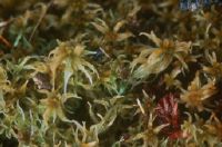
Title (German)
St. Moritz, Torfmoos, Sphagnum magellanica
Record Name
Dia_358-5463

Title (German)
Tourbière des Enfers, Torfmoose berwachsen einen Baum
Caption
Coordinates: 569'600, 237'100. HM 7
Caption (German)
Koordinaten: 569'600, 237'100. HM 7
Record Name
Dia_358-5464

Title (German)
Zopf, Salwiden, Sphagnum angustifolium
Caption
Coordinates: 642'700, 184'900. raised bog Object No. 314: Zopf, Salwiden
Caption (German)
Koordinaten: 642'700, 184'900. Hochmoor Objekt-Nr. 314: Zopf, Salwiden
Record Name
Dia_358-5466

Title (German)
Sphagnum nemoreum scop. = capillifolium
Record Name
Dia_358-5468


Title (German)
Smog über dem Limmattal, Aufnahme vom Versuchsturm Lägern
Record Name
Dia_358-5475

Title (German)
Smog über dem Limmattal, Aufnahme vom Versuchsturm Lägern
Record Name
Dia_358-5476

Title (German)
Mettilimoos, Pilatus
Caption
Coordinates: 649'700, 203'700. raised bog object no. 408. original image no.: 79-3779
Caption (German)
Koordinaten: 649'700, 203'700. Hochmoor Objekt-Nr. 408. Bildnummer Original: 79-3779
Record Name
Dia_358-5477


Title (German)
Tal von Rothenthurm
Caption
Reproduction from: Swissair Flugbild Schweiz, Artemis Verlag, 1973
Caption (German)
Reproduktion aus: Swissair Flugbild Schweiz, Artemis Verlag, 1973
Record Name
Dia_358-5482


Title (German)
Schrattenfluh
Caption
Original image number: 78-2559
Caption (German)
Bildnummer Original: 78-2559
Record Name
Dia_358-5484
![Schrattenfluh, Sörenberg, Flysch in the foreground, Kalte[?] in the background](thumbnails/thumb_ETHBIB.Bildarchiv_1162009.jpg)
Title (German)
Schrattenfluh, Sörenberg, Flysch im Vordergrund, Kalte[?] im Hintergrund
Record Name
Dia_358-5485

Title (German)
Das Moor - wir haben die Wahl
Caption
Reproduction from: Geo Special, Endangered Animals, p. 136, 1982
Caption (German)
Reproduktion aus: Geo Special, Bedrohte Tiere, S. 136, 1982
Record Name
Dia_358-5486

Title (German)
Bachalp, Mäander, der Moorkörper anschneidet
Record Name
Dia_358-5487


Title (German)
Isoliertes Biotop in Agrarflächen
Caption
Reproduction from: Save the Frogs, p. 92, 1985
Caption (German)
Reproduktion aus: Rettet die Frösche, S. 92, 1985
Record Name
Dia_358-5489

Title (German)
Bedrängte Naturlandschaft, Lobsigensee
Record Name
Dia_358-5490

Title (German)
Landschaft während der Eiszeit=Tundra nördlich Baumgrenze in Skandinavien
Caption
Reproduction from: Save the frogs, p. 78, 1985
Caption (German)
Reproduktion aus: Rettet die Frösche, S. 78, 1985
Record Name
Dia_358-5491


Title (German)
Neuenburgersee Südufer, La Grande Cariçaie, traditioneller Schilfschnitt
Record Name
Dia_358-5507

Title (German)
Zerkleinerung der Riedstreu für Kompostierung
Record Name
Dia_358-5508


Title (German)
Geschnittene Fläche mit ELTEL-Maschine
Record Name
Dia_358-5510


![Traces ELTEL, winter [blurred photo].](thumbnails/thumb_ETHBIB.Bildarchiv_1162322.jpg)
Title (German)
Spuren ELTEL, Winter [unscharfe Aufnahme]
Record Name
Dia_358-5516


Title (German)
Riedstreu als Wegstabilisator (anstelle von Geotextil)
Record Name
Dia_358-5532


Title (German)
Bonvillars, Weinberg, Strohballen
Record Name
Dia_358-5540

Title (German)
Bonvillars, Weinberg, Trennen (Halbierung) Strohballen
Record Name
Dia_358-5541

Title (German)
Bonvillars, Weinberg, Strohballen ausbringen, Torfersatz
Record Name
Dia_358-5542

Title (German)
Bonvillars, Weinberg, Strohballen ausbringen
Record Name
Dia_358-5543

Title (German)
Bonvillars, Weinberg, Strohballen ausbringen
Record Name
Dia_358-5544

Title (German)
Bonvillars, Weinberg, Erosion links, dank Streue keine Erosion rechts im Bild
Record Name
Dia_358-5545

Title (German)
Bonvillars, Weinberg, Abschwemmung der Streu nach Unwetter, einziger Fall
Record Name
Dia_358-5546

Title (German)
NSG Auried, Schottische Hochlandrinder
Record Name
Dia_358-5547

Title (German)
NSG Auried, Schottische Hochlandrinder
Record Name
Dia_358-5548

Title (German)
NSG Auried, Schottische Hochlandrinder
Record Name
Dia_358-5549

Title (German)
NSG Auried, Management mit schottischen Hochlandrindern
Record Name
Dia_358-5550

Title (German)
NSG Auried, Management mit schottischen Hochlandrindern
Record Name
Dia_358-5551

Title (German)
NSG Auried, Management mit schottischen Hochlandrindern
Record Name
Dia_358-5552

Title (German)
HM 002, Etang de la Gruère, Torfstichweiher
Caption
Coordinates: 570'600, 232'200. raised bog object no. 2, JU
Caption (German)
Koordinaten: 570'600, 232'200. Hochmoor-Objekt Nr. 2, JU
Record Name
Dia_358-5553

Title (German)
HM 006, Plain de Saigne, Cerneux-Claude, Torfstich
Caption
Coordinates: 573'200, 236'700. raised bog Object No. 6, JU
Caption (German)
Koordinaten: 573'200, 236'700. Hochmoor Objekt-Nr. 6, JU
Record Name
Dia_358-5554

Title (German)
HM 005, Les Embreux, Torfstichweiher
Caption
Coordinates: 575'600, 234'600. raised bog Object No. 5, JU
Caption (German)
Koordinaten: 575'600, 234'600. Hochmoor Objekt-Nr. 5, JU
Record Name
Dia_358-5555

Title (German)
HM 015, Vallée des Ponts-de-Martel (Bois des Lattes / Marais Rouges), Industrielle Abtorfung, Gilgen
Caption
Coordinates: 545'700, 204'200
Caption (German)
Koordinaten: 545’700, 204’200
Record Name
Dia_358-5556

Title (German)
HM 015, Vallée des Ponts-de-Martel (Bois des Lattes / Marais Rouges), Industrielle Abtorfung, Gilgen
Caption
Coordinates: 545'700, 204'200
Caption (German)
Koordinaten: 545’700, 204’200
Record Name
Dia_358-5558


Title (German)
Mettelimoos, alte Torfstichkante
Caption
Coordinates: 649'660, 203'630. raised bog object no. 408, LU
Caption (German)
Koordinaten: 649'660, 203'630. Hochmoor Objekt-Nr. 408, LU
Record Name
Dia_358-5560

Title (German)
HM 304, Schwantenau, verwachsene Torfstichwand mit Calluna vulgaris und Vaccinium spp.
Caption
Coordinates: 698'900, 223'900
Caption (German)
Koordinaten: 698'900, 223'900
Record Name
Dia_358-5561

Title (German)
Gross Moos im Schwendital, Eingriff, Trittschäden durch Vieh
Caption
High moor object no. 245
Caption (German)
Hochmoor Objekt-Nr. 245
Record Name
Dia_358-5562

Title (German)
HM 002, Etang de la Gruère, Trampelpfade
Caption
Coordinates: 570'600, 232'200
Caption (German)
Koordinaten: 570'600, 232'200
Record Name
Dia_358-5592

Title (German)
HM 002, Etang de la Gruère, Trampelpfade
Caption
Coordinates: 570'600, 232'200
Caption (German)
Koordinaten: 570'600, 232'200
Record Name
Dia_358-5593

Title (German)
HM 002, Etang de la Gruère, Trampelpfade
Caption
Coordinates: 570'600, 232'200
Caption (German)
Koordinaten: 570'600, 232'200
Record Name
Dia_358-5594

Title (German)
HM 002, Etang de la Gruère, Trampelpfade
Caption
Coordinates: 570'600, 232'200
Caption (German)
Koordinaten: 570'600, 232'200
Record Name
Dia_358-5595

Title (German)
HM 002, Etang de la Gruère, Bade-Tourismus
Caption
Coordinates: 570'600, 232'200
Caption (German)
Koordinaten: 570'600, 232'200
Record Name
Dia_358-5596

Title (German)
HM 002, Etang de la Gruère, Bade-Tourismus
Caption
Coordinates: 570'600, 232'200
Caption (German)
Koordinaten: 570'600, 232'200
Record Name
Dia_358-5597

Title (German)
HM 002, Etang de la Gruère, Bade-Tourismus
Caption
Coordinates: 570'600, 232'200
Caption (German)
Koordinaten: 570'600, 232'200
Record Name
Dia_358-5598

Title (German)
HM 303, Altmatt-Biberbrugg, Modell-Flying-Ranch, Modellflugplatz
Caption
Coordinates: 694'900, 220'900
Caption (German)
Koordinaten: 694'900, 220'900
Record Name
Dia_358-5599

Title (German)
HM 303, Altmatt-Biberbrugg, Modell-Flying-Ranch, Modellflugplatz
Caption
Coordinates: 694'900, 220'900
Caption (German)
Koordinaten: 694'900, 220'900
Record Name
Dia_358-5600

Title (German)
HM 303, Altmatt-Biberbrugg, Modell-Flying-Ranch, Modellflugplatz, Skizze
Caption
Coordinates: 694'900, 220'900
Caption (German)
Koordinaten: 694'900, 220'900
Record Name
Dia_358-5601

Title (German)
HM 303, Altmatt-Biberbrugg, Modell-Flying-Ranch, Modellflugplatz
Caption
Coordinates: 694'900, 220'900
Caption (German)
Koordinaten: 694'900, 220'900
Record Name
Dia_358-5602

Title (German)
HM 303, Altmatt-Biberbrugg, Modell-Flying-Ranch, Modellflugplatz
Caption
Coordinates: 694'900, 220'900
Caption (German)
Koordinaten: 694'900, 220'900
Record Name
Dia_358-5603

Title (German)
HM 303, Altmatt-Biberbrugg, Modell-Flying-Ranch, Modellflugplatz
Caption
Coordinates: 694'900, 220'900
Caption (German)
Koordinaten: 694'900, 220'900
Record Name
Dia_358-5604

Title (German)
HM 303, Altmatt-Biberbrugg, Modell-Flying-Ranch, Modellflugplatz
Caption
Coordinates: 694'900, 220'900
Caption (German)
Koordinaten: 694'900, 220'900
Record Name
Dia_358-5605

Title (German)
HM 303, Altmatt-Biberbrugg, Modell-Flying-Ranch, Modellflugplatz
Caption
Coordinates: 694'900, 220'900
Caption (German)
Koordinaten: 694'900, 220'900
Record Name
Dia_358-5606

Title (German)
HM 303, Altmatt-Biberbrugg, Modell-Flying-Ranch, Modellflugplatz
Caption
Coordinates: 694'900, 220'900
Caption (German)
Koordinaten: 694'900, 220'900
Record Name
Dia_358-5607

Title (German)
HM 303, Altmatt-Biberbrugg, Modell-Flying-Ranch, Modellflugplatz
Caption
Coordinates: 694'900, 220'900
Caption (German)
Koordinaten: 694'900, 220'900
Record Name
Dia_358-5608

Title (German)
HM 303, Altmatt-Biberbrugg, Modell-Flying-Ranch, Modellflugplatz
Caption
Coordinates: 694'900, 220'900
Caption (German)
Koordinaten: 694'900, 220'900
Record Name
Dia_358-5609

Title (German)
HM 303, Altmatt-Biberbrugg, Modell-Flying-Ranch, Modellflugplatz
Caption
Coordinates: 694'900, 220'900
Caption (German)
Koordinaten: 694'900, 220'900
Record Name
Dia_358-5610

Title (German)
HM 303, Altmatt-Biberbrugg, Modell-Flying-Ranch, Modellflugplatz
Caption
Coordinates: 694'900, 220'900
Caption (German)
Koordinaten: 694'900, 220'900
Record Name
Dia_358-5611

Title (German)
HM 303, Altmatt-Biberbrugg, Modell-Flying-Ranch, Modellflugplatz
Caption
Coordinates: 694'900, 220'900
Caption (German)
Koordinaten: 694'900, 220'900
Record Name
Dia_358-5612

Title (German)
HM 303, Altmatt-Biberbrugg, Modell-Flying-Ranch, Modellflugplatz
Caption
Coordinates: 694'900, 220'900
Caption (German)
Koordinaten: 694'900, 220'900
Record Name
Dia_358-5613

Title (German)
HM 303, Altmatt-Biberbrugg, Modell-Flying-Ranch, Modellflugplatz
Caption
Coordinates: 694'900, 220'900
Caption (German)
Koordinaten: 694'900, 220'900
Record Name
Dia_358-5614

Title (German)
HM 303, Altmatt-Biberbrugg, Modell-Flying-Ranch, Modellflugplatz
Caption
Coordinates: 694'900, 220'900
Caption (German)
Koordinaten: 694'900, 220'900
Record Name
Dia_358-5615

Title (German)
HM 303, Altmatt-Biberbrugg, Modell-Flying-Ranch, Modellflugplatz
Caption
Coordinates: 694'900, 220'900
Caption (German)
Koordinaten: 694'900, 220'900
Record Name
Dia_358-5616

Title (German)
HM 303, Altmatt-Biberbrugg, Modell-Flying-Ranch, Modellflugplatz
Caption
Coordinates: 694'900, 220'900
Caption (German)
Koordinaten: 694'900, 220'900
Record Name
Dia_358-5617

Title (German)
HM 303, Altmatt-Biberbrugg, Modell-Flying-Ranch, Modellflugplatz
Caption
Coordinates: 694'900, 220'900
Caption (German)
Koordinaten: 694'900, 220'900
Record Name
Dia_358-5618

Title (German)
HM 303, Altmatt-Biberbrugg, Modell-Flying-Ranch, Modellflugplatz
Caption
Coordinates: 694'900, 220'900
Caption (German)
Koordinaten: 694'900, 220'900
Record Name
Dia_358-5619

Title (German)
HM 303, Altmatt-Biberbrugg, Modell-Flying-Ranch, Modellflugplatz
Caption
Coordinates: 694'900, 220'900
Caption (German)
Koordinaten: 694'900, 220'900
Record Name
Dia_358-5620

Title (German)
HM 303, Altmatt-Biberbrugg, Modell-Flying-Ranch, Modellflugplatz
Caption
Coordinates: 694'900, 220'900
Caption (German)
Koordinaten: 694'900, 220'900
Record Name
Dia_358-5621

Title (German)
HM 268, Schwendi Kaltbad, Schäden wegen Loipe, Vegetation stellenweise zerstört
Caption
Coordinates: 652'600, 194'500
Caption (German)
Koordinaten: 652'600, 194'500
Record Name
Dia_358-5622

Title (German)
HM 238, Heidsee, Loipe
Caption
Coordinates: 761'100, 178'500
Caption (German)
Koordinaten: 761'100, 178'500
Record Name
Dia_358-5623

Title (German)
HM 238, Heidsee, Bankettschüttung
Caption
Coordinates: 761'100, 178'500
Caption (German)
Koordinaten: 761'100, 178'500
Record Name
Dia_358-5624

Title (German)
Wurzacher Ried, Regeneration, 70 m Damm
Record Name
Dia_358-5715

Title (German)
Wurzacher Ried, Regeneration, Typha und Schilf
Record Name
Dia_358-5716

Title (German)
Wurzacher Ried, Regenerationsfläche
Record Name
Dia_358-5717