 E-PICS - ETHBIB.Bildarchiv


The images presented on this page are part of E-Pics, a service provided by the ETH-Bibliothek of ETH Zurich. You find here static medium resolution images published under the creative commons
CC-BY-SA license or with the Public Domain Mark. This means that you are free to share, copy and redistribute the material in any medium or format; that you are free to remix, transform, and build upon the material for any purpose, even commercially, under the following conditions: You must give appropriate credit, provide a link to the license, and indicate if changes were made.
- More information about E-Pics is available at https://www.e-pics.ethz.ch
- This catalog can also be accessed at https://ba.e-pics.ethz.ch/ . There you can download the image in a higher resolution.

Title (German)
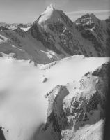
Dolomiten, Sorapis 3205m bei Cortina Marmarole
Record Name
LBS_H1-020509

Title (German)
Dolomiten, Cortina d'Ampezzo, Blick nach Norden (N)
Caption
In the middle ground: Pomagagnon (Punta Fiames), in the background center from left to right: Neunerspitze, Hohe Gaisl, Croda Rossa, Monte Cristallo
Caption (German)
Im Mittelgrund: Pomagagnon (Punta Fiames), im Hintergrund Mitte v.l.n.r.:Neunerspitze, Hohe Gaisl, Croda Rossa, Monte Cristallo
Record Name
LBS_H1-020510

Title (German)
Dolomiten, Colfosco, La Villa, Geissler Spitzen, Blick nach Nordwesten (NW)
Caption
La Villa, Geisler peaks (Fermeda towers & Sass Rigais/Furchetta), Puez plateau
Caption (German)
La Villa, Geislerspitzen (Fermedatürme & Sass Rigais/Furchetta), Puez-Hochfläche
Record Name
LBS_H1-020511


Title (German)
Gargazon, Etschtal, Dolomiten
Record Name
LBS_H1-020515

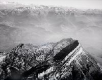
Title (German)
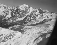
Partschins mit Lodner Spitze 3219m, Vinschgau
Record Name
LBS_H1-020516

Title (German)
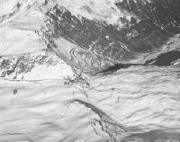
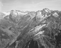
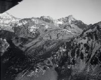
Südtirol, Zufrittkamm der Ortler Alpen mit der Naturnser Hochwart
Caption
View to the southeast of the mountain ridge above Naturno in the Vinschgau Valley with the Naturnser Hochwart (Guardia Alta, 2608 m). This mountain ridge separates the Vinschgau Valley from the Ulten Valley. Above the center you can see the peaks of the next and the next but one mountain ridge: the Laugenspitze (Monte Luco) and the Gantkofel (west of Bolzano).
Caption (German)
Blick nach Südost auf die Bergkrete oberhalb von Naturns im Vinschgau mit der Naturnser Hochwart (Guardia Alta, 2608 m). Diese Bergkrete trennt das Vinschgau vom Ultental. Über der Mitte erkennt man die Spitzen der nächsten und der übernächsten Bergkrete: die Laugenspitze (Monte Luco) und den Gantkofel (westlich von Bozen).
Record Name
LBS_H1-020517

Title (German)
Unteres Martelltal, Ortler-Alpen
Record Name
LBS_H1-020518

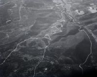
Title (German)
Vinschgau, Tal nördlich hinter Allitz zwischen Laas und Schlanders linke Talseite
Caption
Left from the center: Godriabach and another stream, course of the railroad through Laas, along the Adige river and the loop through Silandro.
Caption (German)
Links aus der Mitte: Godriabach und ein weiterer Bach, Verlauf der Bahn durch Laas, der Etsch entlang und die Schleife durch Schlanders
Record Name
LBS_H1-020519

Title (German)
Vinschgau, Tal nördlich hinter Allitz zwischen Laas und Schlanders linke Talseite
Caption
Left from the center: Godriabach and another stream, course of the railroad through Laas, along the Adige river and the loop through Silandro.
Caption (German)
Links aus der Mitte: Godriabach und ein weiterer Bach, Verlauf der Bahn durch Laas, der Etsch entlang und die Schleife durch Schlanders
Record Name
LBS_H1-020520


Title (German)
Ortlergruppe
Caption
From left: Königsspitze 3851 m, Monte Zebru 3735 m, Ortler 3905 m.
Caption (German)
Von links: Königsspitze 3851 m, Monte Zebru 3735 m, Ortler 3905 m.
Record Name
LBS_H1-020523

Title (German)
Ortlergruppe
Caption
From left: Königsspitze 3851 m, Monte Zebru 3735 m, Ortler 3905 m
Caption (German)
Von links: Königsspitze 3851 m, Monte Zebru 3735 m, Ortler 3905 m
Record Name
LBS_H1-020524

Title (German)
Cevedale-Gruppe
Caption
From left: Zufallspitze 3757 m, Monte Cevedale 3769 m
Caption (German)
Von links: Zufallspitze 3757 m, Monte Cevedale 3769 m
Record Name
LBS_H1-020525
Title (German)
Ortlergruppe
Caption
Left: Königsspitze 3851 m, right: Monte Zebru 3735 m
Caption (German)
Links: Königsspitze 3851 m, rechts: Monte Zebru 3735 m
Record Name
LBS_H1-020526

Title (German)
Cevedale-Gruppe
Caption
From left: Zufallspitze 3757 m, Monte Cevedale 3769 m, Monte Pasquale 3553 m
Caption (German)
Von links: Zufallspitze 3757 m, Monte Cevedale 3769 m, Monte Pasquale 3553 m
Record Name
LBS_H1-020527

Title (German)
Ortlergruppe
Caption
In the background on the left: Cevedale group
Caption (German)
Im Hintergrund links: Cevedalegruppe
Record Name
LBS_H1-020528

Title (German)
Ortlergruppe
Caption
In the background on the left: Cevedale group.
Caption (German)
Im Hintergrund links: Cevedalegruppe.
Record Name
LBS_H1-020529

Title (German)
Ortlergruppe
Caption
Background left: Cevedale group, right: Königsspitze, photo position above Suldental valley
Caption (German)
Hintergrund links: Cevedalegruppe, rechts: Königsspitze, Aufnahmeposition über dem Suldental
Record Name
LBS_H1-020530

Title (German)
Trafoi Tal mit Stilfserjochstrasse, unter Bildmitte: Hotel Franzenshöhe, Blick nach Westen (W)
Record Name
LBS_H1-020531

Title (German)
Trafoi Tal mit Stilfserjochstrasse, unter Bildmitte: Hotel Franzenshöhe, Blick nach Westen (W)
Record Name
LBS_H1-020532


Title (German)
Ortlergruppe
Caption
From left: Monte Zebru, (below the Ortler Pass), Königsspitze, Eiskögelen, Thurwieser-Spitze, Trafoier ice wall, shooting position above the Trafoital.
Caption (German)
Von links: Monte Zebru, (darunter der Ortler-Pass), Königsspitze, Eiskögelen, Thurwieser-Spitze, Trafoier Eiswand, Aufnahmeposition über dem Trafoital
Record Name
LBS_H1-020534
Title (German)
Stilfserjoch, Blick nach Norden (N), Trafoier Tal
Caption
Left above pass summit: Dreisprachenspitze with the ruins of the former Hotel Dreisprachenspitze.
Caption (German)
Links oberhalb Passhöhe: Dreisprachenspitze mit der Ruine des ehemaligen Hotel Dreisprachenspitze.
Record Name
LBS_H1-020535

Title (German)
Stilfserjoch, Blick nach Südosten (SE), Ortler
Caption
In the foreground below: Cantoniera IV on the Stelvio road to Bormio. In the foreground left: Rötlspitz; center: Breitkamm, ending on the right with Dreisprachenspitze; in the background from left: Ortler, Monte Zebru, Il Gran Zebru, Thurwieser, Trafoier Eiswand, Schneeglocke and Geisterspitze.
Caption (German)
Im Vordergrund unten: Cantoniera IV an der Stilfserjochstrasse nach Bormio. Im Vordergrund links: Rötlspitz; Mitte: Breitkamm, der rechts mit der Dreisprachenspitze endet; im Hintergrund von links: Ortler, Monte Zebru, Il Gran Zebru, Thurwieser, Trafoier Eiswand, Schneeglocke und Geisterspitze.
Record Name
LBS_H1-020536

Title (German)
Stilfserjoch, Blick nach Ostsüdosten (ESE), Ortler
Caption
In the background from left: Vertainspitz, Punta Péder di Mezzo, Punta dello Scudo, Zufrittspitze, Ortler, Monte Zebru, Il Gran Zebru, in front: Thurwieser and Trafoier ice wall, behind: Monte Cevedale.
Caption (German)
Im Hintergrund v.l.: Vertainspitz, Punta Péder di Mezzo, Punta dello Scudo, Zufrittspitze, Ortler, Monte Zebru, Il Gran Zebru, davor: Thurwieser und Trafoier Eiswand, dahinter: Monte Cevedale.
Record Name
LBS_H1-020537
Title (German)
Stilfserjoch, Blick nach Ostsüdosten (ESE), Ortler
Caption
In the background from left: Punta Péder di Mezzo, Punta dello Scudo, Zufrittspitze, Ortler, Monte Zebru, Il Gran Zebru, in front: Thurwieser and Trafoier ice wall, behind: Monte Cevedale
Caption (German)
Im Hintergrund v.l.: Punta Péder di Mezzo, Punta dello Scudo, Zufrittspitze, Ortler, Monte Zebru, Il Gran Zebru, davor: Thurwieser und Trafoier Eiswand, dahinter: Monte Cevedale
Record Name
LBS_H1-020538

Title (German)
Stilfserjoch, Blick nach Ostsüdosten (ESE), Ortler
Caption
In the background from left: Punta Péder di Mezzo, Punta dello Scudo, Zufrittspitze, Ortler, Monte Zebru, Il Gran Zebru, Thurwieser and Trafoier Eiswand, behind: Monte Cevedale, Palon de la Mare, Monte Vioz and Punta Taviela.
Caption (German)
Im Hintergrund v.l.: Punta Péder di Mezzo, Punta dello Scudo, Zufrittspitze, Ortler, Monte Zebru, Il Gran Zebru, Thurwieser und Trafoier Eiswand, dahinter: Monte Cevedale, Palon de la Mare, Monte Vioz und Punta Taviela.
Record Name
LBS_H1-020539

Title (German)
Val Nüglia, National Park, Blick nach Norden (N) zum Fluchthorn
Caption
Foreground: Munt da la Bescha, top center: Piz Pisoc, above: Fluchthorn
Caption (German)
Vordergrund: Munt da la Bescha, Mitte oben: Piz Pisoc, darüber: Fluchthorn
Record Name
LBS_H1-020540

Title (German)
Valle di Livigno, Blick nach Südsüdwesten (SSW)
Caption
In the foreground: Munt la Schera, in the background from left: Monte Cassa del Ferro, Cima Paradiso, Cima Valeta, Pizzo Scalino, Piz Varuna, Piz Cambrena, Piz Palü, Piz Zupò and Crast' Agüzza
Caption (German)
Im Vordergrund: Munt la Schera, im Hintergrund v.l.: Monte Cassa del Ferro, Cima Paradiso, Cima Valeta, Pizzo Scalino, Piz Varuna, Piz Cambrena, Piz Palü, Piz Zupò und Crast' Agüzza
Record Name
LBS_H1-020541


Title (German)
Spöltal, Nationalpark, Ofenpass, Ortler, Blick nach Südosten (SE)
Record Name
LBS_H1-020543

Title (German)
Silvrettagruppe, Blick nach Osten (E)
Caption
Center: Lauizughorn, top left: Silvretta glacier, top right: Piz Linard, camera location: about above Klosters (GR).
Caption (German)
Mitte: Lauizughorn, links oben: Silvrettagletscher, rechts oben: Piz Linard, Kamerastandort: etwa über Klosters (GR)
Record Name
LBS_H1-020544

Title (German)
Prättigau, Silvrettagruppe, Blick Osten (E) Gross und Chlein Seehorn
Caption
Foreground: Bockhorn and Geisshorn
Caption (German)
Vordergrund: Bockhorn und Geisshorn
Record Name
LBS_H1-020545
Title (German)
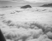
Nebelmeer, Calanda von Norden
Record Name
LBS_H1-020546

Title (German)
Waldnachttal, Urirotstock v. Süd-Ost
Record Name
LBS_H1-020547

Title (German)
Spannort, Schlossberg v. Ost
Record Name
LBS_H1-020548
Title (German)
Maderanertal, Tödi, Oberalpstock
Record Name
LBS_H1-020549


Title (German)
Meiental-Sustenstrasse, Titlis, Sustental Urnerseite
Record Name
LBS_H1-020551


Title (German)
Gotthardstrasse Val Tremola, Blick nach Nordnordwesten (NNW), Sustenhorn
Caption
In the foreground on the left: Fieudo ridge with Banchi trail. Center: Lago di Lucendro. Background from left: Tiefenstock, Rhonestock, Dammastock, Hinter Tierberg, Gwächtenhorn, Sustenhorn and Fleckistock.
Caption (German)
Im Vordergrund links: Fieudograt mit Banchi-Weg. Mitte: Lago di Lucendro. Hintergrund v.l.: Tiefenstock, Rhonestock, Dammastock, Hinter Tierberg, Gwächtenhorn, Sustenhorn und Fleckistock
Record Name
LBS_H1-020553

Title (German)
Gotthardstrasse, Val Tremola, Blick nach Nordwesten (NW), Hospiz
Caption
Left: Fieudograt with the Banchi trail built in 1898.
Caption (German)
Links: Fieudograt mit dem 1898 erstellten Banchi-Weg
Record Name
LBS_H1-020554

Title (German)
Gotthardstrasse Val Tremola, Blick nach Nordnordwesten (NNW), Sustenhorn
Caption
In the foreground on the left: Fieudograt with Lago di Fieud andBanchi trail. Center: Lago di Lucendro. Background from left: Tiefenstock, Rhonestock, Dammastock, Hinter Tierberg, Gwächtenhorn, Sustenhorn and Fleckistock.
Caption (German)
Im Vordergrund links: Fieudograt mit Lago di Fieud undBanchi-Weg. Mitte: Lago di Lucendro. Hintergrund v.l.: Tiefenstock, Rhonestock, Dammastock, Hinter Tierberg, Gwächtenhorn, Sustenhorn und Fleckistock
Record Name
LBS_H1-020555

Title (German)
Gotthardstrasse, Val Tremola, Blick nach Nordwesten (NW), Sustenhorn
Caption
In the foreground ascending: Forte Airolo, Fondoo del Bosco, Motto Bartola, Tremola and Gotthard Pass, in the middle Lago di Lucendro and Monte Prosa, in the background from left: Dammastock, Hinter Tierberg, Gwächtenhorn, Sustenhorn, Fleckistock and Rorspitzli
Caption (German)
Im Vordergrund aufsteigend: Forte Airolo, Fondoo del Bosco, Motto Bartola, Tremola und Gotthardpass, Mitte Lago di Lucendro und Monte Prosa, im Hintergrund v.l.: Dammastock, Hinter Tierberg, Gwächtenhorn, Sustenhorn, Fleckistock und Rorspitzli
Record Name
LBS_H1-020556

Title (German)
Gotthardstrasse, Val Tremola, Blick nach Nordwesten (NW), Hospiz
Caption
Left: Fieudograt with the Banchi trail built in 1898.
Caption (German)
Links: Fieudograt mit dem 1898 erstellten Banchi-Weg
Record Name
LBS_H1-020557


Title (German)
Göschenertal, Blick nach Südwesten (SW), Dammastock
Caption
Center: Göscheneralpsee dam construction site; above: Moosstock; right: Hochschijen, in the background from left: Galenstock, Tiefenstock, Vorderer and Hinterer Rhonestock, Dammastock, Schneestock, Eggstock
Caption (German)
Mitte: Baustelle Staudamm Göscheneralpsee; darüber: Moosstock; rechts: Hochschijen, im Hintergrund v.l.: Galenstock, Tiefenstock, Vorderer und Hinterer Rhonestock, Dammastock, Schneestock, Eggstock
Record Name
LBS_H1-020559

Title (German)
Göschener Alp Tal, Dammastock
Record Name
LBS_H1-020560


Title (German)
Ursental, Furka, Finsteraarhorn-Galenstock
Record Name
LBS_H1-020562


Title (German)
Gotthardstrasse, Tremola, Sustenhorn
Record Name
LBS_H1-020566


Title (German)
Gotthardpass mit Lago di Lucendro, Blick nach Südwesten (SW)
Record Name
LBS_H1-020568

Title (German)
Gotthardpass mit Lago di Lucendro, Blick nach Südwesten (SW)
Caption
Pizzo Lucendro, Pizzo Rotondo and Blinnenhorn
Caption (German)
Pizzo Lucendro, Pizzo Rotondo und Blinnenhorn
Record Name
LBS_H1-020569

Title (German)
Gotthardpass mit Lago di Lucendro, Blick nach Südwesten (SW)
Caption
Pizzo Lucendro and Pizzo Rotondo, on the left: Basòdino
Caption (German)
Pizzo Lucendro und Pizzo Rotondo, links: Basòdino
Record Name
LBS_H1-020570

Title (German)
Gotthardpass mit Lago di Lucendro, Blick nach Westen (W)
Caption
Finsteraarhorn, Lauteraarhorn and Schreckhorn
Caption (German)
Finsteraarhorn, Lauteraar- und Schreckhorn
Record Name
LBS_H1-020571

Title (German)
Gotthardpass mit Lago di Lucendro, Blick nach Südwesten (SW)
Caption
Pizzo Lucendro, Pizzo Rotondo and Blinnenhorn
Caption (German)
Pizzo Lucendro, Pizzo Rotondo und Blinnenhorn
Record Name
LBS_H1-020572

Title (German)
Gotthardpass mit Lago di Lucendro, Blick nach Südwesten (SW)
Caption
Pizzo Lucendro and Pizzo Rotondo, far left: Basòdino
Caption (German)
Pizzo Lucendro und Pizzo Rotondo, ganz links: Basòdino
Record Name
LBS_H1-020573

Title (German)
Ritomsee, Oberalpstock, Tödi
Record Name
LBS_H1-020574

Title (German)
Stausee Sambuco, Fusio-Maggiatal
Record Name
LBS_H1-020575

Title (German)
Stausee Sambuco, Fusio-Maggiatal
Record Name
LBS_H1-020576

Title (German)
Sunnig Wichel, Schattig Wichel, Oberalpstock
Caption
In the foreground: Sunnig Wichel and Schattig Wichel, in the background: Oberalpstock
Caption (German)
Im Vordergrund: Sunnig Wichel und Schattig Wichel, im Hintergrund: Oberalpstock
Record Name
LBS_H1-020577


Title (German)
Schreckhörner, Finsteraarhorn v. Nord-West
Record Name
LBS_H1-020581

Title (German)
Schreckhörner, Finsteraarhorn v. Nord-West
Record Name
LBS_H1-020582

Title (German)
Wetterhorngruppe v. Nord-West
Record Name
LBS_H1-020583


Title (German)
Eiger-Nordwand, Gipfeleisfeld, Schlussabschnitt des Mittellegigrats, Blick nach Südosten (SE)
Caption
Top left: Upper part of the Lauperschild, top right: upper part of the west flank.
Caption (German)
Oben links: Oberster Teil des Lauperschilds, oben rechts: oberster Teil der Westflanke
Record Name
LBS_H1-020585


Title (German)
Blümlisalp, Blick nach Südwesten (SW)
Record Name
LBS_H1-020588

Title (German)
Blümlisalp, Blick nach Südwesten (SW)
Record Name
LBS_H1-020589

Title (German)
Dixence, Lac des Dix
Caption
Bottom center left: Work in progress on the Grande-Dixence dam (1953-1961).
Caption (German)
Unten Mitte links: Arbeiten am Staudamm der Grande-Dixence sind im Gang (1953-1961)
Record Name
LBS_H1-020590

Title (German)
Dixence
Caption
Bottom center: Dam under construction
Caption (German)
Mitte unten: Staumauer in Bau
Record Name
LBS_H1-020591


Title (German)
Glacier de Corbassiere, Grd. Combin
Record Name
LBS_H1-020593

Title (German)
Glacier de Corbassiere, Grd. Combin
Record Name
LBS_H1-020594


Title (German)
Val d'Entremont, Bourg. St. Pierre, Gr. Combin
Record Name
LBS_H1-020596


Title (German)
Dammastock , Blick nach Südosten (SE)
Record Name
LBS_H1-020601


Title (German)
Grand Combin, Blick nach Norden (N)
Caption
In the foreground on the right: Mont Pisonet and Bocca del Merlo, on the left: Bocca di Nonna
Caption (German)
Im Vordergrund rechts: Mont Pisonet und Bocca del Merlo, links: Bocca di Nonna
Record Name
LBS_H1-020603

Title (German)
Grand Combin, Blick nach Norden (N)
Caption
In the foreground: Valpelline valley with Oyace
Caption (German)
Im Vordergrund: Tal Valpelline mit Oyace
Record Name
LBS_H1-020604
Title (German)
Grand Combin, Blick nach Norden (N)
Caption
In the foreground on the right: Mont Pisonet and Bocca del Merlo, on the left: Bocca di Nonna
Caption (German)
Im Vordergrund rechts: Mont Pisonet und Bocca del Merlo, links: Bocca di Nonna
Record Name
LBS_H1-020605


Title (German)
Grosser St. Bernard v. Süden, Dt. du Midi
Record Name
LBS_H1-020613

Title (German)
Grosser Sankt Bernhard, Mont Blanc
Record Name
LBS_H1-020614


Title (German)
Grosser Sankt Bernhard von Süden
Record Name
LBS_H1-020616-AL

Title (German)
Touranache, Breil, Matterhorn von Süden
Record Name
LBS_H1-020617-AL

Title (German)
Lago Serrù, Lago Agnel
Caption
In the background: Mont Blanc, Grandes Jorasses
Caption (German)
Im Hintergrund: Mont Blanc, Grandes Jorasses
Record Name
LBS_H1-020618-AL

Title (German)
Glacier des Evettes
Caption
Left: Uia di Cimarella, top right: Monte Viso
Caption (German)
Links: Uia di Cimarella, rechts oben: Monte Viso
Record Name
LBS_H1-020619

Title (German)
Vallée d’Averole
Caption
Vallée d'Averole, from left to right: Bessanese, Quille d'Arberon, Croix Rousse, far right: Pointe de Charbonnel
Caption (German)
Vallée d’Averole, von links nach rechts: Bessanese, Quille d’Arberon, Croix Rousse, ganz rechts: Pointe de Charbonnel
Record Name
LBS_H1-020620
Title (German)
Mont Nery und Nebental des Valle d’Ayas bei Brusson-Estoul, Aostatal
Caption
View to the southeast over the ridge of Mont de Boussolaz to the wide Alp valley above Brusson in Valle d'Ayas, Valle d'Aosta region. In the center, the alpine pastures around the hamlets of Estoul and Charbonnière. In the background on the right Mont Nery (3076 m). In the background on the left mountains behind the Valle di Gressoney.
Caption (German)
Blick nach Südost über die Krete des Mont de Boussolaz auf das breite Alptal oberhalb von Brusson im Valle d’Ayas, Region Aostatal. Im Mittelpunkt die Alpweiden um die Weiler Estoul und Charbonnière. Im Hintergrund rechts der Mont Nery (3076 m). Im Hintergrund links Berge hinter dem Valle di Gressoney
Record Name
LBS_H1-020621

Title (German)
Uia di Ciamarella
Caption
Center: Uia di Cimarella, behind it: Monte Viso, looking south, far right: pyramid of Rocciamelone.
Caption (German)
Mitte: Uia di Cimarella, dahinter: Monte Viso, Blickrichtung Süd, ganz rechts: Pyramide des Rocciamelone
Record Name
LBS_H1-020622

Title (German)
Saint-Martin-de-la-Porte, mit Bec de l'Aigle, Aufnahmerichtung NNW
Caption
The small river at the bottom of the valley is called Arc. Also at the bottom of the valley, the Lyon-Turin railroad line can be seen, which disappears into the Fréjus tunnel a little further up. Following the ridge, after Bec de l'Aigle, there are Pic du Génie and Grand Perron des Encombres. On the right, the Petit Col des Encombres.
Caption (German)
Das Flüsschen im Talgrund heisst Arc. Ebenfalls im Talgrund ist die Eisenbahnlinie Lyon - Turin erkennbar, die etwas weiter oben in den Tunnel de Fréjus verschwindet. Dem Grat folgend kommen nach dem Bec de l'Aigle noch der Pic du Génie und der Grand Perron des Encombres. Am rechten Bildrand der Petit Col des Encombres.
Record Name
LBS_H1-020623

Title (German)
Glacier des Evettes
Caption
Left: Uia di Cimarella, top right: Monte Viso
Caption (German)
Links: Uia di Cimarella, rechts oben: Monte Viso
Record Name
LBS_H1-020624

Title (German)
Aostatal, Paradiso
Caption
Center: bend of the Aosta Valley near Chatillon, photo taken in the mountains north of Brusson, looking southwest, top center: glaciated Gran Paradiso, right: M. Emilius
Caption (German)
Mitte: Knick des Aostatales bei Chatillon, Aufnahme in den Bergen nördlich von Brusson, Blickrichtung Südwest, oben Mitte: vergletschert Gran Paradiso, rechts: M. Emilius
Record Name
LBS_H1-020625

Title (German)
Aostatal, Blick nach Süden (S), Monte Viso
Record Name
LBS_H1-020626

Title (German)
Gran Paradiso
Caption
Center left: Herbetet, top right: Gran Paradiso, view direction southwest
Caption (German)
Mitte links: Herbetet, oben rechts: Gran Paradiso, Blickrichtung Südwest
Record Name
LBS_H1-020627

Title (German)
Gran Paradiso
Caption
Front right: Herbetet, center: Gran Paradiso, front left Ghiacciaio di Dzasset, behind Ghiacciaio della Tribolazione, view south, far back: Monte Viso
Caption (German)
Vorne rechts: Herbetet, Mitte: Gran Paradiso, vorne links Ghiacciaio di Dzasset, dahinter Ghiacciaio della Tribolazione, Blickrichtung Süd, Ganz hinten: Monte Viso
Record Name
LBS_H1-020628

Title (German)
Gran Paradiso
Caption
Front right: Herbetet, center: Gran Paradiso, front left: Ghiacciaio di Dzasset, behind it Ghiacciaio della Tribolazione, view direction south
Caption (German)
Vorne rechts: Herbetet, Mitte: Gran Paradiso, vorne links: Ghiacciaio di Dzasset, dahinter Ghiacciaio della Tribolazione, Blickrichtung Süd
Record Name
LBS_H1-020629

Title (German)
Gran Paradiso, Italiens Nat. Park
Caption
Foreground: Aosta Valley, right: Valsavarenche, left: Valle di Cogne, view direction south
Caption (German)
Vordergrund: Aostatal, rechts: Valsavarenche, links: Valle di Cogne, Blickrichtung Süd
Record Name
LBS_H1-020630

Title (German)
Gran Paradiso (Mitte), La Tresenta (r.) und Ciarforon, Blick nach Osten (E)
Caption
In the foreground: Valsavarenche
Caption (German)
Im Vordergrund: Valsavarenche
Record Name
LBS_H1-020631

Title (German)
Gran Paradiso, La Grivola (l.), Grand Combin (Mitte), Blick nach Norden (N)
Record Name
LBS_H1-020632

Title (German)
Gran Paradiso, Blick nach Osten (E)
Caption
Top center: Grand Paradiso, to the right: La Tresenta (3609 m), Ciarforon (3642 m), in the foreground: Valsavarenche
Caption (German)
Oben Mitte: Grand Paradiso, rechts davon: La Tresenta (3609 müM), Ciarforon (3642 müM), im Vordergrund: Valsavarenche
Record Name
LBS_H1-020633

Title (German)
Gran Paradiso, Blick nach Osten (E)
Caption
Top center: Grand Paradiso, to the right: La Tresenta (3609 m), Ciarforon (3642 m), in the foreground: Valsavarenche
Caption (German)
Oben Mitte: Grand Paradiso, rechts davon: La Tresenta (3609 müM), Ciarforon (3642 müM), im Vordergrund: Valsavarenche
Record Name
LBS_H1-020634

Title (German)
Gran Paradiso, Blick nach Süden (S)
Caption
Front right: Herbetet (3778 m.a.s.l.); center: Gran Paradiso (4061 m.a.s.l.); front left: Ghiacciaio di Dzasset; behind: Ghiacciaio della Tribolazione
Caption (German)
Vorne rechts: Herbetet (3778 müM); Mitte: Gran Paradiso (4061 müM); vorne links: Ghiacciaio di Dzasset; dahinter: Ghiacciaio della Tribolazione
Record Name
LBS_H1-020635

Title (German)
Gran Paradiso, Blick nach Osten (E)
Caption
Left: Herbetet, center: Grand Paradiso, to the right: La Tresenta (3609 m), in the foreground: Valsavarenche
Caption (German)
Links: Herbetet, Mitte: Grand Paradiso, rechts davon: La Tresenta (3609 müM), im Vordergrund: Valsavarenche
Record Name
LBS_H1-020636

Title (German)
Mont Viso Gebiet
Caption
Pain de Sucre and Asti in the Escreins massif, northwest of Monte Viso. View to the east on the ridge with Pain de Sucre (foreground) and Asti (Mont Aiguillette, 3287 m) along the border France (left) and Italy.
Caption (German)
Pain de Sucre und Asti im Escreins-Massiv, nordwestlich des Monte Viso. Blick nach Ost auf die Krete mit dem Pain de Sucre (Vordergrund) und dem Asti (Mont Aiguillette, 3287 m) entlang der Grenze Frankreich (links) und Italien
Record Name
LBS_H1-020637


Title (German)
Mont Viso Gebiet
Caption
Lac Foréant, Lac Égorgéou, Crête de la Taillante
Caption (German)
Lac Foréant, Lac Égorgéou, Crête de la Taillante
Record Name
LBS_H1-020640

Title (German)
Vanoise Massiv, Grande Casse Nordwand, Blick nach Süden (S)
Caption
Left: Glacier de Rosolin
Caption (German)
Links: Glacier de Rosolin
Record Name
LBS_H1-020641

Title (German)
Frankreich, Pics de Combeynot, oberhalb von Villar-d’Arêne, Hautes-Alpes
Record Name
LBS_H1-020642


Title (German)
Illhorn, Illsee
Caption
In the background: meretschiseen
Caption (German)
Im Hintergrund: Meretschiseen
Record Name
LBS_H1-020644-AL

Title (German)
Cottische Alpen
Caption
Right: Lac Foréant, left: Lac Baricle. The peak in the foreground is Pic de Foréant (3081m). Behind Lac Foréant is the Crête de la Taillante. In the fog is Turin and the Po Valley. The whole is located next to Col Agnel (2744m).
Caption (German)
Rechts: Lac Foréant, links: Lac Baricle. Der Gipfel im Vordergrund ist der Pic de Foréant (3081m). Hinter dem Lac Foréant ist die Crête de la Taillante. Im Nebel liegt Turin und die Poebene. Das ganze ist direkt neben dem Col Agnel (2744m) gelegen.
Record Name
LBS_H1-020645


Title (German)
Les Écrins, Blick nach Südosten (SE)
Record Name
LBS_H1-020650

Title (German)
Dent Parrachée (3697m) von Süden
Caption
Secondary peak on the left: Pointe de la Fournache
Caption (German)
Nebengipfel links: Pointe de la Fournache
Record Name
LBS_H1-020651


Title (German)
Montagne des Agneaux im Écrins-Massiv, nordöstlich von Pelvoux, Dépt. Hautes Alpes, Blick nach Südosten (SE)
Caption
In the background on the left: Monte Viso
Caption (German)
Im Hintergrund links: Monte Viso
Record Name
LBS_H1-020674

Title (German)
Pointe Mathews (l.) und die Grande Casse (r.)
Record Name
LBS_H1-020675

Title (German)
Pointe Mathews (l.) und die Grande Casse (r.)
Record Name
LBS_H1-020676

Title (German)
Dent Parrachée (3697m) von Süden
Caption
Secondary peak on the left: Pointe de la Fournache
Caption (German)
Nebengipfel links: Pointe de la Fournache
Record Name
LBS_H1-020677

Title (German)
Dent Parrachée (3697m) von Süden
Caption
Secondary peak on the left: Pointe de la Fournache
Caption (German)
Nebengipfel links: Pointe de la Fournache
Record Name
LBS_H1-020678

Title (German)
Pointe Mathews (l.) und die Grande Casse (r.)
Record Name
LBS_H1-020679

Title (German)
Massif du Pelvoux, St. Des Rouies v. Nord, Blick nach Südsüdosten (SSE)
Caption
In the foreground from left: Téte du Chéret (3160 m), Pics du Says (3421 m), Pics du Vaccivier (3312 m); left highest: Sommet des Bans (3669 m); right: Sirac (3440 m)
Caption (German)
Im Vordergrund v.l.: Téte du Chéret (3160 müM), Pics du Says (3421 müM), Pics du Vaccivier (3312 müM); links am höchsten: Sommet des Bans (3669 müM); rechts: Sirac (3440 müM)
Record Name
LBS_H1-020680

Title (German)
Massif du Pelvoux, St. Des Rouies v. Nord (N)
Caption
Left: Sommet des Bans (3669 m), right behind: Sirac (3440 m)
Caption (German)
Links: Sommet des Bans (3669 müM), rechts dahinter: Sirac (3440 müM)
Record Name
LBS_H1-020681

Title (German)
Pelvoux Massiv, Blick nach Osten (E)
Caption
Barre des Ecrins (4102 m)
Caption (German)
Barre des Ecrins (4102 müM)
Record Name
LBS_H1-020682

Title (German)
Pelvoux Massiv, Blick nach Osten (E)
Caption
In front half-right: Pic Nord des Cavales, ridge to La Grande Ruine (3765 m), top left in front of the clouds: Pic des Agneaux (3663 m)
Caption (German)
Vorne halbrechts: Pic Nord des Cavales, Krete zu La Grande Ruine (3765 müM), oben links vor den Wolken: Pic des Agneaux (3663 müM)
Record Name
LBS_H1-020683

Title (German)
Pelvoux Massiv, Blick nach Osten (E)
Caption
Barre des Ecrins (4102 m)
Caption (German)
Barre des Ecrins (4102 müM)
Record Name
LBS_H1-020684


Title (German)
La Grande Chartreuse von Süd-Ost
Record Name
LBS_H1-020687
Title (German)
Grande Chartreuse, Pelvoux Massiv
Record Name
LBS_H1-020688


Title (German)
Grande Chartreuse, Pelvoux Massiv
Record Name
LBS_H1-020691

Title (German)
Saint Pierre de Chanteuse bei Grenoble
Record Name
LBS_H1-020692


![Eze near Monaco [blurred image]](thumbnails/thumb_ETHBIB.Bildarchiv_455946.jpg)
Title (German)
Eze bei Monaco [unscharfe Aufnahme]
Record Name
LBS_H1-020700
![Eze near Monaco [blurred image]](thumbnails/thumb_ETHBIB.Bildarchiv_455945.jpg)
Title (German)
Eze bei Monaco [unscharfe Aufnahme]
Record Name
LBS_H1-020701

![Esterel [blurred image]](thumbnails/thumb_ETHBIB.Bildarchiv_455943.jpg)
![Esterel, Cap Roux [blurred image]](thumbnails/thumb_ETHBIB.Bildarchiv_455942.jpg)
Title (German)
Esterel, Cap Roux [unscharfe Aufnahme]
Record Name
LBS_H1-020704
![Esterel, Cap Roux [blurred image]](thumbnails/thumb_ETHBIB.Bildarchiv_455941.jpg)
Title (German)
Esterel, Cap Roux [unscharfe Aufnahme]
Record Name
LBS_H1-020705
![Esterel, Cap Roux [blurred image]](thumbnails/thumb_ETHBIB.Bildarchiv_455940.jpg)
Title (German)
Esterel, Cap Roux [unscharfe Aufnahme]
Record Name
LBS_H1-020706
![Esterel [blurred image]](thumbnails/thumb_ETHBIB.Bildarchiv_455939.jpg)
![Esterel [blurred image]](thumbnails/thumb_ETHBIB.Bildarchiv_455938.jpg)
![Esterel, Cap Roux [blurred image]](thumbnails/thumb_ETHBIB.Bildarchiv_455937.jpg)
Title (German)
Esterel, Cap Roux [unscharfe Aufnahme]
Record Name
LBS_H1-020709

![Esterel, Cap Roux [blurred image]](thumbnails/thumb_ETHBIB.Bildarchiv_455935.jpg)
Title (German)
Esterel, Cap Roux [unscharfe Aufnahme]
Record Name
LBS_H1-020711


Title (German)
Cap de la Croisette, bei Cannes
Record Name
LBS_H1-020723


Title (German)
Strassen bei Colombier, Montélimar
Record Name
LBS_H1-020726


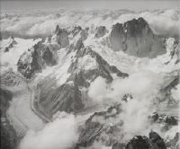
Title (German)
Tour Noir, Pointe Kurz und Mont Dolent, im Mont Blanc Massiv, Blick nach Ostsüdosten (ESE)
Record Name
LBS_H1-020735

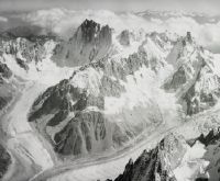
Title (German)
Aiguille du Tacul und Grandes Jorasses, im Mont Blanc Massiv, Blick nach Osten (E)
Record Name
LBS_H1-020736
Title (German)
Grandes Jorasses, Dent du Géant, von Nordwesten
Record Name
LBS_H1-020737

Title (German)
Aiguille des Charmoz, Mont Blanc
Record Name
LBS_H1-020738


Title (German)
Grandes Jorasses Dent du Géant, von Nordwesten
Record Name
LBS_H1-020741
Title (German)
Grandes Jorasses, Mont Blanc, Aiguille du Géant, von Nordwesten
Record Name
LBS_H1-020742

Title (German)
Le Mont Maudit, Mont Blanc , Blick nach Südosten (SE)
Record Name
LBS_H1-020743

Title (German)
La Thuille, Route kl. San. Bernhard
Record Name
LBS_H1-020744

Title (German)
La Thuille, Route kl. San. Bernhard
Record Name
LBS_H1-020745


Title (German)
Lac du Chevril bei Tignes
Caption
Left background: Aiguille de la Grande Sassière
Caption (German)
Links im Hintergrund: Aiguille de la Grande Sassière
Record Name
LBS_H1-020747


Title (German)
Dent Parrachée, Glacier de Rosoire, ca. Blick nach Südosten (SE)
Record Name
LBS_H1-020749

Title (German)
Glacier Blanc mit Torrent de Saint-Pierre im Vordergrund
Caption
Northwest of the village of Pelvoux. The shooting direction is approximately northwest
Caption (German)
Nordwestlich der der Ortschaft Pelvoux. Die Aufnahmerichtung ist ungefähr Nordwest
Record Name
LBS_H1-020750

Title (German)
Dent Parrachée, Glacier de Rosoire, Aufnahmerichtung ca. ESE
Record Name
LBS_H1-020751

Title (German)
Aiguilles im Département Haute-Alpes, Blick nach Osten (E)
Caption
The river at the left edge of the picture is called Guil, the river that flows into the Guil from the right is the Torrent de Peynin. The most prominent peak on the left of the picture and in front of the sea of fog is the Tête de Pelvas
Caption (German)
Der Fluss am linken Bildrand heisst Guil, der Fluss, der sich von rechts in den Guil ergiesst ist der Torrent de Peynin. Der markanteste Gipfel links im Bild und vor dem Nebelmeer ist die Tête de Pelvas
Record Name
LBS_H1-020752

Title (German)
Pointe Rénod, Pointe du Bouchet und Glacier de Chaviére, im Vanoise-Massiv, Savoyen (F)
Caption
View south-southeast to Pointe Rénod, Pointe du Bouchet (3420 m) and to the left Glacier de Chavière. The area is located north of the commune of Saint-André in the valley of the Maurienne a few kilometers below Modane, in the department of Savoie in France
Caption (German)
Blick nach Süd-Südost auf die Pointe Rénod, die Pointe du Bouchet (3420 m) und links davon den Glacier de Chavière. Das Gebiet liegt nördlich der Gemeinde Saint-André im Tal der Maurienne wenige Kilometer unterhalb von Modane, im Departement Savoie in Frankreich
Record Name
LBS_H1-020753

Title (German)
Vanoise Massiv, Grande Casse (r.) Grande Motte (l.)
Record Name
LBS_H1-020754

Title (German)
Monte Berio Blanc und Monte Favre in den Grajischen Alpen, Aostatal, Blick nach Osten (E)
Caption
View to the east over Val Veni (left edge of the picture), Alpe di Chavannes, Monte Favre (2967 m, also called Pointe des Charmonts) and Monte Ber(r)io Blanc (3252 m) in the direction of the Aosta Valley around Courmayeur and Pré-St-Didier. We are directly south of Mont Blanc. The alpine meadows sloping down to the right are Alpe di Chavannes and Alpe Berrio Blanc. Right: Valley floor of the Vallon des Chavannes leading down to La Thuile.
Caption (German)
Blick nach Ost über das Val Veni (linker Bildrand), die Alpe di Chavannes, den Monte Favre (2967 m, auch Pointe des Charmonts genannt) und den Monte Ber(r)io Blanc (3252 m) in die Richtung des Aostatals um Courmayeur und Pré-St-Didier. Wir befinden uns direkt südlich des Mont Blanc. Die schräg nach rechts abfallenden Alpwiesen sind die Alpe di Chavannes und die Alpe Berrio Blanc. Rechts: Talboden des Vallon des Chavannes, das nach La Thuile hinunterführt
Record Name
LBS_H1-020755


Title (German)
Dent Parrachée, Glacier de Rosoire, Aufnahmerichtung E
Caption
Pointe Observatoire (3012m), Tête d'Aussois (3024m) and Roche Chevrière (3276m)
Caption (German)
Pointe Observatoire (3012m), Tête d'Aussois (3024m) und Roche Chevrière (3276m)
Record Name
LBS_H1-020757

Title (German)
Dent Parrachée, Glacier de la Vanoise, Aufnahmerichtung S
Caption
Left: Dôme de Chasseforêt
Caption (German)
Links: Dôme de Chasseforêt
Record Name
LBS_H1-020758

Title (German)
Stausee Le Drac, Nähe La Mure (Departement Isère)
Record Name
LBS_H1-020759

Title (German)
Dents de Lanfon und die Dent de Cruet
Caption
In the foreground, on the left, the valley of the little river Le Fier. From the left, partially on the horizon, the Chaîne des Aravis is visible. On the horizon to the right of the center, Mont Blanc dominates. The pyramid a little to the left and below Mont Blanc the Pointe de Merdassier is visible
Caption (German)
Im Vordergrund links das Tal des Flüsschens Le Fier. Von links teilweise am Horizont ist die Chaîne des Aravis zu erkennen. Am Horizont rechts der Mitte dominiert der Montblanc. Die Pyramide etwas links und unter dem Montblanc ist die Pointe de Merdassier zu erkennen
Record Name
LBS_H1-020760

Title (German)
Cheval Noir und Col de la Madeleine, Vanoise-Massiv, Savoie, Blick nach Ostnordosten (ENE)
Caption
View of the side valley (today ski resort) of Longchamps, commune of St-François-Longchamp, in the valley of the Maurienne, department of Savoie. In the center the Col de la Madeleine (1993 m) and above it the summit of the Cheval Noir (2832 m) in the Massif de la Vanoise.
Caption (German)
Blickauf das Nebental (heute Skigebiet) von Longchamps, Gemeinde St-François-Longchamp, im Tal der Maurienne, Département Savoie. In der Mitte der Col de la Madeleine (1993 m) und darüber der Gipfel des Cheval Noir (2832 m) im Massif de la Vanoise
Record Name
LBS_H1-020761

Title (German)
Zusammenfluss der Asse de Clumanc (l.) mit der Asse de Moriez (r.), Blick nach Nordosten (NE)
Caption
The few houses at the confluence are called La Basse Palud. The whole is on the territory of the municipality of Barrême. The snowy mountains in the background belong to the Parc national du Mercantour. The prominent ridge that runs pretty much across the picture culminates in Sommet de Mouchon (1593m). The hill in the middle is called Le Clap and has an altitude of 1247m
Caption (German)
Die paar Häuser am Zusammenfluss heissen La Basse Palud. Das Ganze liegt auf dem Gebiet der Gemeinde Barrême. Die verschneiten Berge im Hintergrund gehören zum Parc national du Mercantour. Der markante Rücken, der sich ziemlich genau quer durch das Bild zieht, gipfelt im Sommet de Mouchon (1593m). Der Hügel in Mitte heisst Le Clap und hat eine Höhe von 1247m
Record Name
LBS_H1-020762

Title (German)
Mont Charvin, rechts dahinter der Mont Blanc, Blick nach Osten (E)
Caption
Center: Valley of La Chaise. The prominent, slightly snow-covered peak at the right edge of the picture is Dent de Cons
Caption (German)
Mitte: Tal der La Chaise. Der markante, leicht verschneite Gipfel am rechten Bildrand ist die Dent de Cons
Record Name
LBS_H1-020763

Title (German)
Bellaffaire, Brézier und Weiler Les Champsaurs, Aufnahmerichtung ONO
Caption
The conspicuous hill on the upper left is called Mouisset. The small river that meanders through the picture from left to right below is called Torrent de Clapouse
Caption (German)
Der auffälligen Hügel links oben heisst Mouisset. Das Flüsschen, das sich von links nach rechts unten durch das Bild schlängelt heisst Torrent de Clapouse
Record Name
LBS_H1-020764


Title (German)
Sanctuaire Notre-Dame du Laus
Caption
Right: Vallée de l'Avance
Caption (German)
Rechts: Vallée de l'Avance
Record Name
LBS_H1-020766

Title (German)
Mont Granier, Dent de Crolles (Chartreuse) von Süden
Record Name
LBS_H1-020767

Title (German)
Vallée de la Lescherette, Savoie, Blick nach Südwesten (SW)
Caption
In the background: Chaine de Belledonne, wing of the Douglas C-47, HB-IRF
Caption (German)
Im Hintergrund: Chaine de Belledonne, Tragfläche der Douglas C-47, HB-IRF
Record Name
LBS_H1-020768

Title (German)
Vallée des Villards, Savoie, Blick nach Südwesten (SW)
Caption
Center left: Saint-Colomban-des-Villards, Saint-Alban-des-Villards, right: mountains of the Chaine de Belledonne; back left: Col du Glandon. Wing of the Douglas C-47, HB-IRF
Caption (German)
Mitte links: Saint-Colomban-des-Villards, Saint-Alban-des-Villards, rechts: Berge der Chaine de Belledonne; links hinten: Col du Glandon. Tragfläche der Douglas C-47, HB-IRF
Record Name
LBS_H1-020769

Title (German)
Pic de Peyre Eyraute im Massif du Queyras, Hautes-Alpes, Blick nach Südwesten (SW)
Caption
Wing of Douglas C-47, HB-IRF
Caption (German)
Tragfläche der Douglas C-47, HB-IRF
Record Name
LBS_H1-020770

Title (German)
Ort unbekannt
Caption
Wing of Douglas C-47, HB-IRF
Caption (German)
Tragfläche der Douglas C-47, HB-IRF
Record Name
LBS_H1-020771

Title (German)
Cusy mit Crêt de Châtillon im Hintergrund
Caption
The limestone hill on the right in the foreground: foothills of the Massif des Bauges, the small river in the foreground: Chéran, in the background in the center: Mont Blanc
Caption (German)
Der Kalkhügel rechts im Vordergrund: Ausläufer des Massif des Bauges, das Flüsschen im Vordergrund: Chéran, im Hintergrund in Mitte: der Mont Blanc
Record Name
LBS_H1-020772

Title (German)
Saint-Jean-d'Arvey mit Mont Peney
Caption
Left foreground: the summit of the Croix du Nivolet, behind it: the valley of the Leysse, in the middle on the horizon: Mont Blanc
Caption (German)
Links im Vordergrund: der Gipfel des Croix du Nivolet, dahinter: das Tal der Leysse, in der Mitte am Horizont: der Mont Blanc
Record Name
LBS_H1-020773


Title (German)
Grande Tête de l'Obiou, Blick nach Westen (W)
Caption
In the foreground and slightly covered with snow is the Crête de la Samblue. The whole belongs to the Massif du Dévoluy.
Caption (German)
Ganz links am Bildrand: Tête de Lapras.Im Vordergrund und leicht verschneit ist die Crête de la Samblue. Das Ganze gehört zum Massif du Dévoluy.
Record Name
LBS_H1-020776

Title (German)
Grand Ferrand, Blick nach Westsüdwesten (WSW)
Caption
On the right, completely covered by snow: the Tête de l'Aupet. Further to the right: the rocky summit of the Tête de Lapras. The prominent limestone rock a little to the left of the center is the Grand Brechon. The valley is the valley of La Souloise. The whole range belongs to the Massif du Dévoluy
Caption (German)
Rechts, gänzlich verschneit: die Tête de l'Aupet. Weiter nach rechts: der felsige Gipfel der Tête de Lapras. Der markante Kalkfelsen etwas links der Mitte ist der Grand Brechon. Das Tal ist das Tal der La Souloise. Die ganze Kette gehört zum Massif du Dévoluy
Record Name
LBS_H1-020777


Title (German)
Nördliches Ende des Lac d'Annecy mit Annecy am linken Bildrand
Caption
Right back on the horizon: Mont Blanc (4809m), the range of hills on the eastern side of the lake: Mont Veyrier
Caption (German)
Rechts hinten am Horizont: Mont Blanc (4809m), der Hügelzug auf der östlichen Seeseite: Mont Veyrier
Record Name
LBS_H1-020779

Title (German)
Dent de Crolles, 2062m
Caption
About 17km NE of Grenoble, Mont Blanc (4809m) on the left, Grande Casse (3875m) on the right.
Caption (German)
Ca. 17km NE von Grenoble, am Horizont links zu erkennen der Mont Blanc (4809m), am Horizont rechts die Grande Casse (3875m)
Record Name
LBS_H1-020780


Title (German)
Chamrousse und Livet-et-Gavet im Tal der Romanche
Caption
Photo taken about above the village of Séchilienne, looking northeast (NE)
Caption (German)
Aufnahme etwa über der Ortschaft Séchilienne, Blick nach Nordost (NO)
Record Name
LBS_H1-020782

Title (German)
Tal des Ruisseau d'Hermillon, Pointe du Vallon, Cime Noire
Record Name
LBS_H1-020783

Title (German)
Pic de Morgon, Montagne du Col Bas
Record Name
LBS_H1-020784

Title (German)
Saint-Michel-en-Beaumont, Villelonge
Caption
Valley of the Malsanne, Pic de la Pyramide, Pointe de Malhaubert, Le Coiro
Caption (German)
Tal der Malsanne, Pic de la Pyramide, Pointe de Malhaubert, Le Coiro
Record Name
LBS_H1-020785


Title (German)
Lavaldens in der Vallée de la Roizonne
Caption
La Pyramide, Grandes Rousses, Crête des Barres, shooting direction NE.
Caption (German)
La Pyramide, Grandes Rousses, Crête des Barres, Aufnahmerichtug NE.
Record Name
LBS_H1-020787

Title (German)
Lavaldens in der Vallée de la Roizonne
Caption
La Pyramide, Grandes Rousses, Le Grand Armet, Recording NE.
Caption (German)
La Pyramide, Grandes Rousses, Le Grand Armet, Aufnahmerichtug NE.
Record Name
LBS_H1-020788

Title (German)
Vallée de la Luye, La Rochette, Puy de Manse
Caption
In the foreground left: Hill La Rochette, in the background: Ancelle
Caption (German)
Im Vordergrund links: Hügel La Rochette, im Hintergrund: Ancelle
Record Name
LBS_H1-020789

Title (German)
Roche de la Muzelle, Pic du Clapier du Peyron, La Meije, von Süden (S)
Caption
Highest peak left of center: Roche de la Muzelle, left of it: Pic du Clapier du Peyron, in the distance, 1/5 image width from right edge: La Meije
Caption (German)
Höchster Gipfel links der Mitte: Roche de la Muzelle, links davon: Pic du Clapier du Peyron, in der Ferne, 1/5 Bildbreite vom rechten Bildrand: La Meije
Record Name
LBS_H1-020790

Title (German)
Vallée du Drac
Caption
In the foreground on the right: Saint Laurent du Cros, on the left of it: Le Cros, on the other side of the Drac: Saint-Julien-en-Champsaur, highest peak, a bit left of center: Vieux Chaillol, on the left of it on the horizon the Barre des Écrins
Caption (German)
Im Vordergrund rechts: Saint Laurent du Cros, links davon: Le Cros, auf der anderen Seite der Drac: Saint-Julien-en-Champsaur, höchster Gipfel, etwas links der Mitte: Vieux Chaillol, links davon am Horizont die Barre des Écrins
Record Name
LBS_H1-020791

Title (German)
Crête de Géruen, Pic de Morgon
Record Name
LBS_H1-020792

Title (German)
Pic du Clapier de Peyron, Roche de la Muzelle
Caption
Front: Valley of the Séveraisse, shooting direction approximately N.
Caption (German)
Vorne: Tal der Séveraisse, Aufnahmerichtung ungefähr N.
Record Name
LBS_H1-020793


Title (German)
Avançon in der Vallée de l'Avance
Caption
Left: Pointe de la Diablée, taking approx. NE.
Caption (German)
Links: Pointe de la Diablée, Aufnahmerichtung ca. NE.
Record Name
LBS_H1-020795

Title (German)
Vallée du Drac
Caption
In the foreground, under the limestone cliff La Rochette, in the snowy plain in the middle, Ancelles, on the far left on the horizon the Barre des Écrins is visible
Caption (German)
Im Vordergrund unter der Kalkklippe La Rochette, in der verschneiten Ebene in Mitte, Ancelles, ganz links am Horizont ist die Barre des Écrins sichtbar
Record Name
LBS_H1-020796

Title (German)
Sommet de Lieye
Caption
Southeast of Barrême
Caption (German)
Südöstlich von Barrême
Record Name
LBS_H1-020797


Title (German)
Vallée de la Durance mit Espinasse
Caption
The barracks camp is Chaussetives, built for the construction of the dam for Lac de Serre-Ponçon. The construction work took place between 1957 and 1959. The valley in the background is flooded today
Caption (German)
Das Barackenlager ist Chaussetives, das für den Bau des Staudamms für den Lac de Serre-Ponçon gebaut wurde. Die Bauarbeiten fanden zwischen 1957 und 1959 statt. Das Tal im Hintergrund ist heute überflutet
Record Name
LBS_H1-020799
Title (German)
Spillgerte, Blick nach Südosten (SE)
Record Name
LBS_H1-020800

Title (German)
Oldenhorn 3126m, Blick nach Südosten (SE)
Record Name
LBS_H1-020801

Title (German)
Rigi, Blick nach Westen (W)
Caption
Summits from left: Rigi Hohfluh, Rigi Dossen, Rigi Kulm, in the background: Pilatus
Caption (German)
Gipfel v.l.: Rigi Hohfluh, Rigi Dossen, Rigi Kulm, im Hintergrund: Pilatus
Record Name
LBS_H1-020802


Title (German)
Brunnen, Vierwaldstättersee, Pilatus
Record Name
LBS_H1-020805
Title (German)
Brunnen, Pilatus
Caption
Flown high
Caption (German)
Hochgeflogen
Record Name
LBS_H1-020806


Title (German)
Flüelen
Caption
At the goods bridge (at the height of the church): MS "Reuss", built in 1925/26 by Gebr. Sachsenberg in Rosslau on the Elbe, in the fleet of the SGV until approx. 2012 and is now a private boat.
Caption (German)
An der Güterbrücke (auf Höhe Kirche): MS "Reuss", 1925/26 von den Gebr. Sachsenberg in Rosslau an der Elbe erbaut, bis ca. 2012 in der Flotte der SGV und ist heute Privatboot
Record Name
LBS_H1-020809


Title (German)
Vitznau, Ferienhaus, Metall und Uhrenarbeiter
Record Name
LBS_H1-020814


Title (German)
Malleray, Pontenet, Loveresse, Reconvilier, Le Fuet
Caption
In the background on the left: Tavannes
Caption (German)
Im Hintergrund links: Tavannes
Record Name
LBS_H1-020820

Title (German)
Malleray, Bévilard, Sorvilier, Court
Record Name
LBS_H1-020821

Title (German)
Reconvilier, Blick nach Westnordwesten (WNW)
Record Name
LBS_H1-020822

Title (German)
Reconvilier, Blick nach Nordosten (NE)
Record Name
LBS_H1-020823

Title (German)
Tavannes
Caption
In the background: Le Fuet
Caption (German)
Im Hintergrund: Le Fuet
Record Name
LBS_H1-020824


Title (German)
Obersee, Linth, Speer, Federispitz
Caption
In front of the influence of the Linth Canal: MS "Linth", built in 1951/52 by the Bodanwerft shipyard in Kressbronn
Caption (German)
Vor dem Einfluss des Linthkanals: MS "Linth", erbaut 1951/52 von der Bodanwerft in Kressbronn
Record Name
LBS_H1-020828

Title (German)
Motorschiff "Linth"
Caption
MS "Linth" first three-decker in Switzerland, built in 1951/52 at the Bodan shipyard in Kressbronn, still in service today in a gently modernized form
Caption (German)
MS "Linth" erster Dreidecker der Schweiz, erbaut 1951/52 auf der Bodanwerft in Kressbronn, heute in sanft modernisierter Form noch im Dienst
Record Name
LBS_H1-020829

Title (German)
Obersee, Motorschiff "Linth"
Caption
MS "Linth" first three-decker in Switzerland, built 1951/52 at the Bodan shipyard in Kressbronn, still in service today in a gently modernized form
Caption (German)
MS "Linth" erster Dreidecker der Schweiz, erbaut 1951/52 auf der Bodanwerft in Kressbronn, heute in sanft modernisierter Form noch im Dienst
Record Name
LBS_H1-020830


Title (German)
Brücke der Rickenstrasse über die Ranzach
Caption
Between St. Gallenkappel and Gebertingen
Caption (German)
Zwischen St. Gallenkappel und Gebertingen
Record Name
LBS_H1-020839

Title (German)
Brücke der Rickenstrasse über die Ranzach
Caption
Between St. Gallenkappel and Gebertingen
Caption (German)
Zwischen St. Gallenkappel und Gebertingen
Record Name
LBS_H1-020840


Title (German)
Schmerikon, Uznach, Speer, Federispitz
Record Name
LBS_H1-020842


Title (German)
Schmerikon
Caption
Train station, church
Caption (German)
Bahnhof, Kirche
Record Name
LBS_H1-020844


Title (German)
Dietlikon, Gärtnerei Hänni
Caption
Nurseries
Caption (German)
Gärtnereien
Record Name
LBS_H1-020850


Title (German)
Mollis, Baustelle im Gäsi für den Kerenzerberg-Eisenbahntunnel samt Vorbereitungsarbeiten für die Walenseestrasse
Record Name
LBS_H1-020852

Title (German)
Mollis, Baustelle im Gäsi für den Kerenzerberg-Eisenbahntunnel samt Vorbereitungsarbeiten für die Walenseestrasse
Record Name
LBS_H1-020853


Title (German)
Sargans, Wohnhaus Bereiter
Record Name
LBS_H1-020856-AL


Title (German)
Zizers, Kinderheim Gott hilft
Caption
Image border above: Igis, view northeast
Caption (German)
Bildrand oben: Igis, Blick Nordosten
Record Name
LBS_H1-020860


Title (German)
Innerthal, Wägitalersee mit Staumauer Schräh
Record Name
LBS_H1-020869


Title (German)
Diepoldsau, Rheinlauf
Caption
Right: Old course of the Alpine Rhine, also called Hohenems Bay
Caption (German)
Rechts: Altlauf des Alpenrheins, auch genannt Hohenemser Bucht
Record Name
LBS_H1-020872

Title (German)
Diepoldsau, Rheinlauf
Caption
Right: Old course of the Alpine Rhine, also called Hohenems Bay
Caption (German)
Rechts: Altlauf des Alpenrheins, auch genannt Hohenemser Bucht
Record Name
LBS_H1-020873

Title (German)
Diepoldsau, Rheinlauf
Caption
Right: Old course of the Alpine Rhine, also called Hohenems Bay
Caption (German)
Rechts: Altlauf des Alpenrheins, auch genannt Hohenemser Bucht
Record Name
LBS_H1-020874

Title (German)
Balgach, Heerbrugg, Widnau
Caption
Center: Company Wild, Heerbrugg
Caption (German)
Mitte: Firma Wild, Heerbrugg
Record Name
LBS_H1-020875

Title (German)
Hoher Kasten, Altmann, Säntis
Record Name
LBS_H1-020876


Title (German)
Winkel (ZH), Haus Spörrle, Buechenweg 17
Record Name
LBS_H1-020881

Title (German)
Winkel (ZH), Haus Spörrle, Buechenweg 17
Record Name
LBS_H1-020882

Title (German)
Winkel (ZH), Haus Spörrle, Buechenweg 17
Record Name
LBS_H1-020883

Title (German)
Winkel (ZH), Haus Spörrle, Buechenweg 17
Record Name
LBS_H1-020884

Title (German)
Winkel (ZH), Haus Spörrle, Buechenweg 17
Record Name
LBS_H1-020885


Title (German)
Gap, Blick nach Ostnordosten (ENE)
Record Name
LBS_H1-020889


Title (German)
Le Grand Canyon du Verdon, bei Rougon, Département Alpes-de-Haute-Provence
Record Name
LBS_H1-020900


Title (German)
Pic Melette, nordwestlich von Gap, Hautes-Alpes
Record Name
LBS_H1-020904

Title (German)
Massif du Dévoluy mit Tête de Garnesier und Tête des Ormans, über La Cluse, nordwestlich von Gap, Hautes-Alpes
Caption
View to west-southwest on the southwestern mountains of the Massiv du Dévoluy above the village of La Cluse (lower left) in the department of Hautes-Alpes. In the center the Tête des Ormans (2140 m), on the right among others the Tête de Garnesier (2367 m). Since 2013 La Cluse belongs to the large municipality of Dévoluy
Caption (German)
Blick nach West-Südwest auf die südwestlichen Berge des Massiv du Dévoluy über der Ortschaft La Cluse (links unten) im Département Hautes-Alpes. In der Mitte die Tête des Ormans (2140 m), rechts u.a. die Tête de Garnesier (2367 m). Seit 2013 gehört La Cluse zur Grossgemeinde Dévoluy
Record Name
LBS_H1-020905


Title (German)
Hinterland von Cannes bei Auribeau-sur-Siagne, Département Alpes-Maritimes, Blick nach Ostnordosten (ENE)
Record Name
LBS_H1-020912

Title (German)
Hügel des Estérel, bei Les Adrets-de-l’Estérel, zwischen Grasse und Fréjus, Département Var
Caption
View to southwest, in the background: Fréjus
Caption (German)
Blick nach Südwest, im Hintergrund: Fréjus
Record Name
LBS_H1-020913


Title (German)
Andelfingen, Kleinandelfingen, Übersicht
Caption
Flown high
Caption (German)
Hochgeflogen
Record Name
LBS_H1-020920


Title (German)
Dägerlen, mit Weilern Rutschwil und Berg, nördlich von Winterthur
Record Name
LBS_H1-020925


Title (German)
Andelfingen, Kleinandelfingen
Record Name
LBS_H1-020932


Title (German)
Rheinau
Caption
bridges river courses monasteries
Caption (German)
Brücken Flussläufe Klöster
Record Name
LBS_H1-020939


Title (German)
Römischer Wachturm bei Rheinau
Record Name
LBS_H1-020944


Title (German)
Flughafen Kloten
Caption
Left EL-AL 4X-AKA Lockheed L-049 Constellation, center front HB-IBI DC-6B, center rear HB-ILI DC-4, right HB-IBU DC-6B
Caption (German)
Links EL-AL 4X-AKA Lockheed L-049 Constellation, Mitte vorne HB-IBI DC-6B, Mitte hinten HB-ILI DC-4, rechts HB-IBU DC-6B
Record Name
LBS_H1-020950

Title (German)
Bristol Britannia-102 G-ANBF der British Overseas Airways Corporation, Blick nach Osten (E)
Record Name
LBS_H1-020951


Title (German)
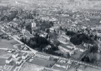
Olten, Altstadt, Blick nach Nordnordwesten (NNW)
Record Name
LBS_H1-020955


Title (German)
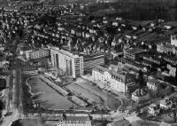
Langendorf, Lanco AG, Blick nach Nordnordosten (NNE)
Caption
Center: artificial ice rink, built in 1956
Caption (German)
Mitte: Kunsteisbahn, erbaut 1956
Record Name
LBS_H1-020957
Title (German)
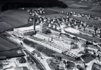
Langendorf, Lanco AG, Blick nach Nordwesten (NW)
Caption
Center: artificial ice rink, built in 1956
Caption (German)
Mitte: Kunsteisbahn, erbaut 1956
Record Name
LBS_H1-020958
Title (German)
Solothurn, Blick nach Osten (E)
Record Name
LBS_H1-020959

Title (German)
Solothurn, Blick nach Osten (E)
Record Name
LBS_H1-020960


Title (German)
Sörenberg, Skigebiet, Hundsknubel
Record Name
LBS_H1-020968


Title (German)
Melchsee, Frutt, Skigebiet
Caption
Center: Top station ski lift Erzegg
Caption (German)
Mitte: Bergstation Skilift Erzegg
Record Name
LBS_H1-020972


Title (German)
Vierwaldstättersee, Obere und Untere Nase
Record Name
LBS_H1-020981


Title (German)
Basel, Mustermesse, Blick nach Nordosten (NE)
Record Name
LBS_H1-020984


Title (German)
Basel, Mustermesse, Blick nach Nordosten (NE)
Record Name
LBS_H1-020986

Title (German)
Basel, Rheinhafen Kleinhüningen, Blick nach Nordosten (NE)Basel, Rheinhafen Kleinhüningen, Blick nach Nordosten (NE)
Caption
In many Rhine harbor pictures until about 1970 almost always appearing dark sludge in the middle of the river: Waste water from the Basel slaughterhouse
Caption (German)
In vielen Rheinhafenbilder bis gegen 1970 fast immer in Erscheinung tretende dunkle Schliere in Flussmitte: Abwasser des Schlachthofes Basel
Record Name
LBS_H1-020987


Title (German)
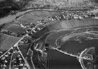
Kadelburg, Rhein, Rietheim (AG), Ebene Rifeld
Caption
Left: Kadelburg and Rhine, right: Rifeld plain near Rietheim (AG).
Caption (German)
Links: Kadelburg und Rhein, rechts: Ebene Rifeld bei Rietheim (AG)
Record Name
LBS_H1-020990

Title (German)
Rietheim (AG), Ebene Rifeld, Rhein mit Stromschnelle "Ettikoner Lauffen"
Record Name
LBS_H1-020991


Title (German)
Augst, Römisches Theater, Museum
Record Name
LBS_H1-020994

Title (German)
Augst, Römisches Theater, Museum
Record Name
LBS_H1-020995


Title (German)
Dornach, Goetheanum, Blick nach Nordosten (NE)
Caption
Low flown
Caption (German)
Tiefgeflogen
Record Name
LBS_H1-021000

Title (German)
Aesch (BL)
Caption
Low flown
Caption (German)
Tiefgeflogen
Record Name
LBS_H1-021001

Title (German)
Aesch (BL), Blick nach Nordwesten (NW)
Caption
Low flown
Caption (German)
Tiefgeflogen
Record Name
LBS_H1-021002

Title (German)
Aesch (BL), Blick nach Nordwesten (NW)
Caption
Low flown
Caption (German)
Tiefgeflogen
Record Name
LBS_H1-021003

Title (German)
Mellikon, Steinbruch der Sodawerke Zurzach
Caption
Low flown
Caption (German)
Tiefgeflogen
Record Name
LBS_H1-021004

Title (German)
Schwaderloch
Caption
Low flown
Caption (German)
Tiefgeflogen
Record Name
LBS_H1-021005

Title (German)
Zurzach
Caption
Low flown
Caption (German)
Tiefgeflogen
Record Name
LBS_H1-021006

Title (German)
Zurzach
Caption
Low flown
Caption (German)
Tiefgeflogen
Record Name
LBS_H1-021007