 E-PICS - ETHBIB.Bildarchiv


The images presented on this page are part of E-Pics, a service provided by the ETH-Bibliothek of ETH Zurich. You find here static medium resolution images published under the creative commons
CC-BY-SA license or with the Public Domain Mark. This means that you are free to share, copy and redistribute the material in any medium or format; that you are free to remix, transform, and build upon the material for any purpose, even commercially, under the following conditions: You must give appropriate credit, provide a link to the license, and indicate if changes were made.
- More information about E-Pics is available at https://www.e-pics.ethz.ch
- This catalog can also be accessed at https://ba.e-pics.ethz.ch/ . There you can download the image in a higher resolution.

Title (German)
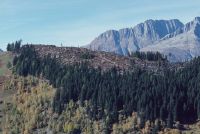
Medel (Lucmagn) GR, 1-4: Westansicht des Uaul da Curaglia, 5-24: Blick hangabwärts über den Uaul da Curaglia nach Curaglia
Caption
View downslope over the more temporary avalanche works in the upgraded windthrow area, on the Curaglia valley floor, general view; keywords Documenta Natura: windthrow, mountain forest, clearing work, wood storage
Caption (German)
Blick hangabwärts über die temporäreren Lawinenwerke in der aufgerüsteten Windwurffläche, im Talboden Curaglia, Gesamtansicht; Schlagworte Documenta Natura: Windwurf, Gebirgswald, Raeumungsarbeit, Holzlagerung
Record Name
Dia_303-32220

Title (German)
Medel (Lucmagn) GR, 1-4: Westansicht des Uaul da Curaglia, 5-24: Blick hangabwärts über den Uaul da Curaglia nach Curaglia
Caption
View downslope over the more temporary avalanche works in the upgraded windthrow area, on the Curaglia valley floor, general view; keywords Documenta Natura: windthrow, mountain forest, clearing work, wood storage
Caption (German)
Blick hangabwärts über die temporäreren Lawinenwerke in der aufgerüsteten Windwurffläche, im Talboden Curaglia, Gesamtansicht; Schlagworte Documenta Natura: Windwurf, Gebirgswald, Raeumungsarbeit, Holzlagerung
Record Name
Dia_303-32223

Title (German)
Medel (Lucmagn) GR, 1-4: Westansicht des Uaul da Curaglia, 5-24: Blick hangabwärts über den Uaul da Curaglia nach Curaglia
Caption
Temporary avalanche works in rake construction, on the Curaglia valley floor, partial view downslope; keywords Documenta Natura: windthrow, mountain forest, clearing work, wood storage.
Caption (German)
Temporäre Lawinenwerke in Rechenkonstruktion, im Talboden Curaglia, Teilansicht hangabwärts; Schlagworte Documenta Natura: Windwurf, Gebirgswald, Raeumungsarbeit, Holzlagerung
Record Name
Dia_303-32226

Title (German)
Medel (Lucmagn) GR, 1-4: Westansicht des Uaul da Curaglia, 5-24: Blick hangabwärts über den Uaul da Curaglia nach Curaglia
Caption
View over the temporary avalanche works, on the Curaglia valley floor, partial view downhill; keywords Documenta Natura: windthrow, mountain forest, clearing work, wood storage
Caption (German)
Blick über die temporären Lawinenwerke, im Talboden Curaglia, Teilansicht hangabwärts; Schlagworte Documenta Natura: Windwurf, Gebirgswald, Raeumungsarbeit, Holzlagerung
Record Name
Dia_303-32229

Title (German)
Medel (Lucmagn) GR, 1-4: Westansicht des Uaul da Curaglia, 5-24: Blick hangabwärts über den Uaul da Curaglia nach Curaglia
Caption
Temporary avalanche works in rake construction, on the Curaglia valley floor, partial view downslope; keywords Documenta Natura: windthrow, mountain forest, clearing work, wood storage.
Caption (German)
Temporäre Lawinenwerke in Rechenkonstruktion, im Talboden Curaglia, Teilansicht hangabwärts; Schlagworte Documenta Natura: Windwurf, Gebirgswald, Raeumungsarbeit, Holzlagerung
Record Name
Dia_303-32232

Title (German)
Medel (Lucmagn) GR, Im Westhang Uaul da Curaglia oberhalb Curaglia
Caption
Construction workers fitting and erecting a support pillar made of chestnut wood in the temporary shoring, in the shoring area; keywords Documenta Natura: windthrow, mountain forest, clearing work, wood storage
Caption (German)
Bauarbeiter beim Einpassen und Aufrichten eines Stützpfeilers aus Kastanienholz in der Temporärverbauung, im Verbauungsgebiet; Schlagworte Documenta Natura: Windwurf, Gebirgswald, Raeumungsarbeit, Holzlagerung
Record Name
Dia_303-32246

Title (German)
Medel (Lucmagn) GR, Im Westhang Uaul da Curaglia oberhalb Curaglia
Caption
Construction workers fitting and erecting a support pillar made of chestnut wood in the temporary shoring, in the shoring area; keywords Documenta Natura: windthrow, mountain forest, clearing work, wood storage
Caption (German)
Bauarbeiter beim Einpassen und Aufrichten eines Stützpfeilers aus Kastanienholz in der Temporärverbauung, im Verbauungsgebiet; Schlagworte Documenta Natura: Windwurf, Gebirgswald, Raeumungsarbeit, Holzlagerung
Record Name
Dia_303-32251

Title (German)
Medel (Lucmagn) GR, Im Westhang Uaul da Curaglia oberhalb Curaglia
Caption
New temporary avalanche works (rake construction), timber works (chestnuts) in the upgraded windthrow area, partial view across the slope; keywords Documenta Natura: windthrow, mountain forest, clearing work, timber storage.
Caption (German)
Neue temporäre Lawinenwerke (Rechenkonstruktion), Holzwerk (Kastanien) im aufgerüsteten Windwurfflächenschaden, Teilansicht quer zum Hang; Schlagworte Documenta Natura: Windwurf, Gebirgswald, Raeumungsarbeit, Holzlagerung
Record Name
Dia_303-32257

Title (German)
Medel (Lucmagn) GR, Im Westhang Uaul da Curaglia oberhalb Curaglia
Caption
New temporary avalanche works (rake construction), timber works (chestnuts) in upgraded windthrow damage, partial view upslope; keywords Documenta Natura: windthrow, mountain forest, clearing work, timber storage.
Caption (German)
Neue temporäre Lawinenwerke (Rechenkonstruktion), Holzwerk (Kastanien) im aufgerüsteten Windwurfflächenschaden, Teilansicht hangaufwärts; Schlagworte Documenta Natura: Windwurf, Gebirgswald, Raeumungsarbeit, Holzlagerung
Record Name
Dia_303-32260

Title (German)
Medel (Lucmagn) GR, Im Westhang Uaul da Curaglia oberhalb Curaglia
Caption
New temporary avalanche works (rake construction), timber works (chestnuts) in upgraded windthrow damage, partial view upslope; keywords Documenta Natura: windthrow, mountain forest, clearing work, timber storage.
Caption (German)
Neue temporäre Lawinenwerke (Rechenkonstruktion), Holzwerk (Kastanien) im aufgerüsteten Windwurfflächenschaden, Teilansicht hangaufwärts; Schlagworte Documenta Natura: Windwurf, Gebirgswald, Raeumungsarbeit, Holzlagerung
Record Name
Dia_303-32263

Title (German)
Medel (Lucmagn) GR, Im Westhang Uaul da Curaglia oberhalb Curaglia
Caption
New temporary avalanche works (rake construction), timber works (chestnuts) in upgraded windthrow damage, partial view upslope; keywords Documenta Natura: windthrow, mountain forest, clearing work, timber storage.
Caption (German)
Neue temporäre Lawinenwerke (Rechenkonstruktion), Holzwerk (Kastanien) im aufgerüsteten Windwurfflächenschaden, Teilansicht hangaufwärts; Schlagworte Documenta Natura: Windwurf, Gebirgswald, Raeumungsarbeit, Holzlagerung
Record Name
Dia_303-32266

Title (German)
Medel (Lucmagn) GR, Im Westhang Uaul da Curaglia oberhalb Curaglia
Caption
New temporary avalanche works (rake construction), timber works (chestnuts) in the upgraded windthrow area, partial view across the slope; keywords Documenta Natura: windthrow, mountain forest, clearing work, timber storage.
Caption (German)
Neue temporäre Lawinenwerke (Rechenkonstruktion), Holzwerk (Kastanien) im aufgerüsteten Windwurfflächenschaden, Teilansicht quer zum Hang; Schlagworte Documenta Natura: Windwurf, Gebirgswald, Raeumungsarbeit, Holzlagerung
Record Name
Dia_303-32269

Title (German)
Medel (Lucmagn) GR, Im Westhang Uaul da Curaglia oberhalb Curaglia
Caption
New temporary avalanche works (rake construction), timber works (chestnuts) in the upgraded windthrow area, partial view from below; Keywords Documenta Natura: windthrow, mountain forest, clearing work, timber storage.
Caption (German)
Neue temporäre Lawinenwerke (Rechenkonstruktion), Holzwerk (Kastanien) im aufgerüsteten Windwurfflächenschaden, Teilansicht von unten; Schlagworte Documenta Natura: Windwurf, Gebirgswald, Raeumungsarbeit, Holzlagerung
Record Name
Dia_303-32272

Title (German)
Medel (Lucmagn) GR, Im Westhang Uaul da Curaglia oberhalb Curaglia
Caption
New temporary avalanche works (rake construction), timber works (chestnuts) in upgraded windthrow damage, detail view across slope; keywords Documenta Natura: windthrow, mountain forest, clearing work, timber storage.
Caption (German)
Neue temporäre Lawinenwerke (Rechenkonstruktion), Holzwerk (Kastanien) im aufgerüsteten Windwurfflächenschaden, Detailansicht quer zum Hang; Schlagworte Documenta Natura: Windwurf, Gebirgswald, Raeumungsarbeit, Holzlagerung
Record Name
Dia_303-32275

Title (German)
Medel (Lucmagn) GR, Im Westhang Uaul da Curaglia oberhalb Curaglia
Caption
Concreted support pillars made of chestnut, new temporary avalanche works (rake construction) in the upgraded windthrow area, detail view across the slope; keywords Documenta Natura: windthrow, mountain forest, clearing work, timber storage.
Caption (German)
Einbetonierte Stützpfeiler aus Kastanie, neue temporäre Lawinenwerke (Rechenkonstruktion) im aufgerüsteten Windwurfflächenschaden, Detailansicht quer zum Hang; Schlagworte Documenta Natura: Windwurf, Gebirgswald, Raeumungsarbeit, Holzlagerung
Record Name
Dia_303-32277

Title (German)
Medel (Lucmagn) GR, Im Westhang Uaul da Curaglia oberhalb Curaglia
Caption
Concreted support pillar made of chestnut, new temporary avalanche works (rake construction) in upgraded windthrow damage, detail view upslope; keywords Documenta Natura: windthrow, mountain forest, clearing work, timber storage.
Caption (German)
Einbetonierter Stützpfeiler aus Kastanie, neue temporäre Lawinenwerke (Rechenkonstruktion) im aufgerüsteten Windwurfflächenschaden, Detailansicht hangaufwärts; Schlagworte Documenta Natura: Windwurf, Gebirgswald, Raeumungsarbeit, Holzlagerung
Record Name
Dia_303-32280

Title (German)
Medel (Lucmagn) GR, Im Westhang Uaul da Curaglia oberhalb Curaglia
Caption
Concreted support pillar made of chestnut, new temporary avalanche works (rake construction) in upgraded windthrow damage, detail view upslope; keywords Documenta Natura: windthrow, mountain forest, clearing work, timber storage.
Caption (German)
Einbetonierter Stützpfeiler aus Kastanie, neue temporäre Lawinenwerke (Rechenkonstruktion) im aufgerüsteten Windwurfflächenschaden, Detailansicht hangaufwärts; Schlagworte Documenta Natura: Windwurf, Gebirgswald, Raeumungsarbeit, Holzlagerung
Record Name
Dia_303-32283

Title (German)
Medel (Lucmagn) GR, Im Westhang Uaul da Curaglia oberhalb Curaglia
Caption
Storage of material with iron straps and counterparts on terrace in the construction area, in the background Curaglia; keywords Documenta Natura: windthrow, mountain forest, clearing work, wood storage
Caption (German)
Materiallager mit Bandeisen und Gegenstücken auf Terrasse im Verbauungsgebiet, im Hintergrund Curaglia; Schlagworte Documenta Natura: Windwurf, Gebirgswald, Raeumungsarbeit, Holzlagerung
Record Name
Dia_303-32285

Title (German)
Medel (Lucmagn) GR, Im Westhang Uaul da Curaglia oberhalb Curaglia
Caption
Small terrace on forest road with building material, compressor plant, in windthrow damage; keywords Documenta Natura: windthrow, mountain forest, clearing work, wood storage.
Caption (German)
Kleine Terrasse an Forststrasse mit Baumaterial, Kompressoranlage, im Windwurfflächenschaden; Schlagworte Documenta Natura: Windwurf, Gebirgswald, Raeumungsarbeit, Holzlagerung
Record Name
Dia_303-32288

Title (German)
Medel (Lucmagn) GR, Im Westhang Uaul da Curaglia oberhalb Curaglia
Caption
Small terrace with rope crane system in windthrow area damage, temporary shoring; keywords Documenta Natura: windthrow, mountain forest, clearing work, timber storage.
Caption (German)
Kleine Terrasse mit Seilkrananlage im Windwurfflächenschaden, temporäre Verbauungen; Schlagworte Documenta Natura: Windwurf, Gebirgswald, Raeumungsarbeit, Holzlagerung
Record Name
Dia_303-32291

Title (German)
Medel (Lucmagn) GR, Im Westhang Uaul da Curaglia oberhalb Curaglia
Caption
Transport of a wheelbarrow uphill with rope crane over the windthrow area; keywords Documenta Natura: windthrow, mountain forest, clearing work, wood storage
Caption (German)
Transport eines Schubkarren bergaufwärts mit Seilkran über die Windwurffläche; Schlagworte Documenta Natura: Windwurf, Gebirgswald, Raeumungsarbeit, Holzlagerung
Record Name
Dia_303-32295

Title (German)
Medel (Lucmagn) GR, Im Westhang Uaul da Curaglia oberhalb Curaglia
Caption
Transport of a wheelbarrow uphill with rope crane over the windthrow area; keywords Documenta Natura: windthrow, mountain forest, clearing work, wood storage
Caption (German)
Transport eines Schubkarren bergaufwärts mit Seilkran über die Windwurffläche; Schlagworte Documenta Natura: Windwurf, Gebirgswald, Raeumungsarbeit, Holzlagerung
Record Name
Dia_303-32297

Title (German)
Medel (Lucmagn) GR, Im Westhang Uaul da Curaglia oberhalb Curaglia
Caption
Construction worker unloading wheelbarrow, with rope crane; keywords Documenta Natura: windthrow, mountain forest, clearing work, wood storage
Caption (German)
Bauarbeiter beim Ausladen des Schubkarren, mit Seilkran; Schlagworte Documenta Natura: Windwurf, Gebirgswald, Raeumungsarbeit, Holzlagerung
Record Name
Dia_303-32299

Title (German)
Medel (Lucmagn) GR, Im Westhang Uaul da Curaglia oberhalb Curaglia
Caption
Transport of a wheelbarrow with rope crane; keywords Documenta Natura: windthrow, mountain forest, clearing work, wood storage
Caption (German)
Transport eines Schubkarren mit Seilkran; Schlagworte Documenta Natura: Windwurf, Gebirgswald, Raeumungsarbeit, Holzlagerung
Record Name
Dia_303-32304

Title (German)
Medel (Lucmagn) GR, Im Westhang Uaul da Curaglia oberhalb Curaglia
Caption
Transport of a wheelbarrow with rope crane; keywords Documenta Natura: windthrow, mountain forest, clearing work, wood storage
Caption (German)
Transport eines Schubkarren mit Seilkran; Schlagworte Documenta Natura: Windwurf, Gebirgswald, Raeumungsarbeit, Holzlagerung
Record Name
Dia_303-32305

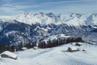
Medel (Lucmagn) GR, south view of the hamlet Gliarauns and the opposite slope with the hamlet Soliva
Title (German)
Medel (Lucmagn) GR, Südansicht des Weilers Gliarauns und dem Gegenhang mit dem Weiler Soliva
Caption
South view of the hamlet Gliarauns with the upgraded windthrow area and the opposite slope with the hamlet Soliva, general view; keywords Documenta Natura: windthrow, mountain forest, clearing work, wood storage
Caption (German)
Südansicht des Weilers Gliarauns mit dem aufgerüsteten Windwurfflächenschaden und dem Gegenhang mit dem Weiler Soliva, Gesamtansicht; Schlagworte Documenta Natura: Windwurf, Gebirgswald, Raeumungsarbeit, Holzlagerung
Record Name
Dia_303-32310

Medel (Lucmagn) GR, south view of the hamlet Gliarauns and the opposite slope with the hamlet Soliva
Title (German)
Medel (Lucmagn) GR, Südansicht des Weilers Gliarauns und dem Gegenhang mit dem Weiler Soliva
Caption
South view of the hamlet Gliarauns with the upgraded windthrow area and the opposite slope with the hamlet Soliva, partial view; keywords Documenta Natura: windthrow, mountain forest, clearing work, wood storage
Caption (German)
Südansicht des Weilers Gliarauns mit dem aufgerüsteten Windwurfflächenschaden und dem Gegenhang mit dem Weiler Soliva, Teilansicht; Schlagworte Documenta Natura: Windwurf, Gebirgswald, Raeumungsarbeit, Holzlagerung
Record Name
Dia_303-32313

Medel (Lucmagn) GR, south view of the hamlet Gliarauns and the opposite slope with the hamlet Soliva
Title (German)
Medel (Lucmagn) GR, Südansicht des Weilers Gliarauns und dem Gegenhang mit dem Weiler Soliva
Caption
South view of the hamlet Gliarauns with the upgraded windthrow area and the opposite slope with the hamlet Soliva, partial view; keywords Documenta Natura: windthrow, mountain forest, clearing work, wood storage
Caption (German)
Südansicht des Weilers Gliarauns mit dem aufgerüsteten Windwurfflächenschaden und dem Gegenhang mit dem Weiler Soliva, Teilansicht; Schlagworte Documenta Natura: Windwurf, Gebirgswald, Raeumungsarbeit, Holzlagerung
Record Name
Dia_303-32316

Title (German)
Medel (Lucmagn) GR, Im Wald Uaul da Curaglia oberhalb Curaglia
Caption
View across the slope over the windthrow litter damage area with fallen and still standing spruce trees, partial view; Keywords Documenta Natura: windthrow, mountain forest, clearing work, timber storage.
Caption (German)
Blick quer zum Hang über die Windwurfstreuschadenfläche mit umgeworfenen und noch stehenden Fichten, Teilansicht; Schlagworte Documenta Natura: Windwurf, Gebirgswald, Raeumungsarbeit, Holzlagerung
Record Name
Dia_303-32319

Title (German)
Medel (Lucmagn) GR, Im Wald Uaul da Curaglia oberhalb Curaglia
Caption
View upslope over the windthrow litter damage area with fallen and still standing spruce trees, partial view; Keywords Documenta Natura: windthrow, mountain forest, clearing work, timber storage.
Caption (German)
Blick hangaufwärts über die Windwurfstreuschadenfläche mit umgeworfenen und noch stehenden Fichten, Teilansicht; Schlagworte Documenta Natura: Windwurf, Gebirgswald, Raeumungsarbeit, Holzlagerung
Record Name
Dia_303-32322

Title (German)
Medel (Lucmagn) GR, Val Medel mit Curaglia, Fadretsch, Mutschnengia (Teil) und dem Uaul da Curaglia, im Hintergrund (z. T.) Piz Muraun, Piz Cazirauns, Denter Corns, Piz Caschleglia und Piz Ault
Caption
Northwest view of Val Medel with Curaglia, Fadretsch and Mutschnengia (partial), with windthrow damage in the protection forest Uaul da Curaglia, in the background the mountain range with Piz Muraun, Piz Cazirauns, Denter Corns, Piz Caschleglia and Piz Ault, first photo 1990, partial view; coordinates (LV03) of camera location: 707835/170255; keywords Documenta Natura: windthrow, mountain forest, clearing work, wood storage.
Caption (German)
Nordwestansicht des Val Medel mit Curaglia, Fadretsch und Mutschnengia (teilweise), mit Windwurfflächenschaden im Schutzwald Uaul da Curaglia, im Hintergrund die Gebirgskette mit Piz Muraun, Piz Cazirauns, Denter Corns, Piz Caschleglia und Piz Ault, Erstaufnahme 1990, Teilansicht; Koordinaten (LV03) des Kamerastandorts: 707835/170255; Schlagworte Documenta Natura: Windwurf, Gebirgswald, Raeumungsarbeit, Holzlagerung
Record Name
Dia_303-32324

Title (German)
Medel (Lucmagn) GR, Val Medel mit Curaglia, Fadretsch, Mutschnengia (Teil) und dem Uaul da Curaglia, im Hintergrund (z. T.) Piz Muraun, Piz Cazirauns, Denter Corns, Piz Caschleglia und Piz Ault
Caption
Northwestern view of Val Medel with Curaglia, Fadretsch and Mutschnengia (partial), with windthrow damage in the protection forest Uaul da Curaglia, in the background the mountain range (partial) with Piz Muraun, Piz Cazirauns, Denter Corns, Piz Caschleglia and Piz Ault, 1st photo. Follow-up photo in winter 1992, partial view; coordinates (LV03) of the camera location: 707835/170255; keywords Documenta Natura: windthrow, mountain forest, clearing work, wood storage
Caption (German)
Nordwestansicht des Val Medel mit Curaglia, Fadretsch und Mutschnengia (teilweise), mit Windwurfflächenschaden im Schutzwald Uaul da Curaglia, im Hintergrund die Gebirgskette (zum Teil) mit Piz Muraun, Piz Cazirauns, Denter Corns, Piz Caschleglia und Piz Ault, 1. Folgeaufnahme im Winter 1992, Teilansicht; Koordinaten (LV03) des Kamerastandorts: 707835/170255; Schlagworte Documenta Natura: Windwurf, Gebirgswald, Raeumungsarbeit, Holzlagerung
Record Name
Dia_303-32332

Title (German)
Medel (Lucmagn) GR, Im Westhang Uaul da Curaglia oberhalb Curaglia
Caption
Due to storm "Vivian" uprooted (windthrow) and broken (windbreak) spruces, partial view "uphill"; keywords Documenta Natura: windthrow, mountain forest, clearing work, wood storage
Caption (German)
Durch Sturm Vivian" entwurzelte (Windwurf) und umgebrochene (Windbruch) Fichten, Teilansicht hangaufwärts"; Schlagworte Documenta Natura: Windwurf, Gebirgswald, Raeumungsarbeit, Holzlagerung
Record Name
Dia_303-32364

Title (German)
Medel (Lucmagn) GR, Im Westhang Uaul da Curaglia oberhalb Curaglia
Caption
Spruce trees uprooted (windthrow) and broken (windbreak) by storm "Vivian", on the Curaglia valley floor, partial view downslope; Keywords Documenta Natura: windthrow, mountain forest, clearing work, wood storage
Caption (German)
Durch Sturm "Vivian" entwurzelte (Windwurf) und umgebrochene (Windbruch) Fichten, im Talboden Curaglia, Teilansicht hangabwärts; Schlagworte Documenta Natura: Windwurf, Gebirgswald, Raeumungsarbeit, Holzlagerung
Record Name
Dia_303-32367

Title (German)
Medel (Lucmagn) GR, Im Westhang Uaul da Curaglia oberhalb Curaglia
Caption
Spruce trees uprooted (windthrow) and broken (windbreak) by storm "Vivian", partial view across the slope; keywords Documenta Natura: windthrow, mountain forest, clearing work, wood storage
Caption (German)
Durch Sturm "Vivian" entwurzelte (Windwurf) und umgebrochene (Windbruch) Fichten, Teilansicht quer zum Hang; Schlagworte Documenta Natura: Windwurf, Gebirgswald, Raeumungsarbeit, Holzlagerung
Record Name
Dia_303-32370

Title (German)
Medel (Lucmagn) GR, Im Westhang Uaul da Curaglia oberhalb Curaglia
Caption
Spruce trees uprooted (windthrow) and broken (windbreak) by storm "Vivian", partial view across the slope; keywords Documenta Natura: windthrow, mountain forest, clearing work, wood storage
Caption (German)
Durch Sturm "Vivian" entwurzelte (Windwurf) und umgebrochene (Windbruch) Fichten, Teilansicht quer zum Hang; Schlagworte Documenta Natura: Windwurf, Gebirgswald, Raeumungsarbeit, Holzlagerung
Record Name
Dia_303-32376

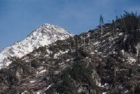
Title (German)
Medel (Lucmagn) GR, Im Westhang Uaul da Curaglia oberhalb Curaglia
Caption
By storm "Vivian" fallen (wind break) spruce, detailed view; Keywords Documenta Natura: Windthrow, mountain forest, clearing work, wood storage
Caption (German)
Durch Sturm "Vivian" umgebrochene (Windbruch) Fichte, Detailansicht; Schlagworte Documenta Natura: Windwurf, Gebirgswald, Raeumungsarbeit, Holzlagerung
Record Name
Dia_303-32379

Title (German)
Medel (Lucmagn) GR, Zentrum von Curaglia mit dem Nordwesthang im Hintergrund
Caption
Curaglia with the main road (Lukmanierstrasse), in the background the northwest slope with the windthrow damage (spring storm Vivian), partial view; Keywords Documenta Natura: windthrow, mountain forest, clearing work, wood storage
Caption (German)
Curaglia mit der Hauptstrasse (Lukmanierstrasse), im Hintergrund der Nordwesthang mit dem Windwurfflächenschaden (Frühjahrssturm Vivian), Teilansicht; Schlagworte Documenta Natura: Windwurf, Gebirgswald, Raeumungsarbeit, Holzlagerung
Record Name
Dia_303-32382

Title (German)
Medel (Lucmagn) GR, Zentrum von Curaglia mit dem Nordwesthang im Hintergrund
Caption
Curaglia with the main road (Lukmanierstrasse), in the background the northwest slope with the windthrow damage (spring storm Vivian), partial view; Keywords Documenta Natura: windthrow, mountain forest, clearing work, wood storage
Caption (German)
Curaglia mit der Hauptstrasse (Lukmanierstrasse), im Hintergrund der Nordwesthang mit dem Windwurfflächenschaden (Frühjahrssturm Vivian), Teilansicht; Schlagworte Documenta Natura: Windwurf, Gebirgswald, Raeumungsarbeit, Holzlagerung
Record Name
Dia_303-32385

Title (German)
Medel (Lucmagn) GR, Platta
Caption
Residential house on the street with tree collapsed on house roof edge with rootstock, the tree trunk is already cut into beams, general view; keywords Documenta Natura: windthrow, mountain forest, clearing work, wood storage
Caption (German)
Wohnhaus an der Strasse mit auf Hausdachkannte eingestürzter Baum mit Wurzelstock, der Baumstamm ist bereits in Trämel geschnitten, Gesamtansicht; Schlagworte Documenta Natura: Windwurf, Gebirgswald, Raeumungsarbeit, Holzlagerung
Record Name
Dia_303-32392

Title (German)
Medel (Lucmagn) GR, Platta
Caption
Residential house on the street with tree collapsed on house roof edge with rootstock, the tree trunk is already cut into beams, partial view; keywords Documenta Natura: windthrow, mountain forest, clearing work, wood storage
Caption (German)
Wohnhaus an der Strasse mit auf Hausdachkannte eingestürzter Baum mit Wurzelstock, der Baumstamm ist bereits in Trämel geschnitten, Teilansicht; Schlagworte Documenta Natura: Windwurf, Gebirgswald, Raeumungsarbeit, Holzlagerung
Record Name
Dia_303-32395
Title (German)
Disentis/Mustér, Medel (Lucmagn) GR, Blick über Caischavedra nach Südosten mit Piz Muraun, Piz Cazirauns, Denter Corns, Piz Caschleglia und Piz Ault
Caption
View over the Alp Caischavedra to the southeast over the two windthrow areas of Disentis and Curaglia, mountain range with Piz Muraun, Piz Cazirauns, Denter Corns, Piz Caschleglia and Piz Ault, photo taken in early spring (snow-covered), general view; keywords Documenta Natura: windthrow, mountain forest, clearing work, wood storage
Caption (German)
Blick über die Alp Caischavedra nach Südosten über die beiden Windwurfflächenschaden von Disentis und Curaglia, Gebirgskette mit Piz Muraun, Piz Cazirauns, Denter Corns, Piz Caschleglia und Piz Ault, Aufnahme im Vorfrühling (schneebedeckt), Gesamtansicht; Schlagworte Documenta Natura: Windwurf, Gebirgswald, Raeumungsarbeit, Holzlagerung
Record Name
Dia_303-32402

Title (German)
Disentis/Mustér, Medel (Lucmagn) GR, Blick über Caischavedra nach Südosten mit Piz Muraun, Piz Cazirauns, Denter Corns, Piz Caschleglia und Piz Ault
Caption
View over the Alp Caischavedra to the southeast over the two windthrow areas of Disentis and Curaglia, mountain range with Piz Muraun, Piz Cazirauns, Denter Corns, Piz Caschleglia and Piz Ault, photo taken in early spring (snow-covered), general view; keywords Documenta Natura: windthrow, mountain forest, clearing work, wood storage
Caption (German)
Blick über die Alp Caischavedra nach Südosten über die beiden Windwurfflächenschaden von Disentis und Curaglia, Gebirgskette mit Piz Muraun, Piz Cazirauns, Denter Corns, Piz Caschleglia und Piz Ault, Aufnahme im Vorfrühling (schneebedeckt), Gesamtansicht; Schlagworte Documenta Natura: Windwurf, Gebirgswald, Raeumungsarbeit, Holzlagerung
Record Name
Dia_303-32408

Title (German)
Disentis/Mustér, Medel (Lucmagn) GR, Blick über Caischavedra nach Südosten mit Piz Muraun, Piz Cazirauns, Denter Corns, Piz Caschleglia und Piz Ault
Caption
View over the Alp Caischavedra to the southeast over the two windthrow areas of Disentis and Curaglia, mountain range with Piz Muraun, Piz Cazirauns, Denter Corns, Piz Caschleglia and Piz Ault, photo taken in early spring (snow-covered), general view; keywords Documenta Natura: windthrow, mountain forest, clearing work, wood storage
Caption (German)
Blick über die Alp Caischavedra nach Südosten über die beiden Windwurfflächenschaden von Disentis und Curaglia, Gebirgskette mit Piz Muraun, Piz Cazirauns, Denter Corns, Piz Caschleglia und Piz Ault, Aufnahme im Vorfrühling (schneebedeckt), Gesamtansicht; Schlagworte Documenta Natura: Windwurf, Gebirgswald, Raeumungsarbeit, Holzlagerung
Record Name
Dia_303-32412

Title (German)
Disentis/Mustér, Medel (Lucmagn) GR, Blick über Caischavedra nach Südosten mit Piz Muraun, Piz Cazirauns, Denter Corns, Piz Caschleglia und Piz Ault
Caption
View over the Alp Caischavedra to the southeast over the two windthrow areas of Disentis and Curaglia, mountain range with Piz Muraun, Piz Cazirauns, Denter Corns, Piz Caschleglia and Piz Ault, photo taken in early spring (snow-covered), general view; keywords Documenta Natura: windthrow, mountain forest, clearing work, wood storage
Caption (German)
Blick über die Alp Caischavedra nach Südosten über die beiden Windwurfflächenschaden von Disentis und Curaglia, Gebirgskette mit Piz Muraun, Piz Cazirauns, Denter Corns, Piz Caschleglia und Piz Ault, Aufnahme im Vorfrühling (schneebedeckt), Gesamtansicht; Schlagworte Documenta Natura: Windwurf, Gebirgswald, Raeumungsarbeit, Holzlagerung
Record Name
Dia_303-32414

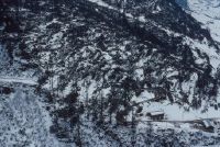
Title (German)
Medel (Lucmagn) GR, Nordosthang Uaul dils Plauns und Osthang Uaul da Vergera, z. T. im Vordergrund Fadretsch
Caption
Northeast view of the northeast slope with the windthrow area in Uaul dils Plauns, partly in the foreground Fadretsch (southern part), first photograph 1990 (snow covered), partial view; keywords Documenta Natura: windthrow, mountain forest, clearing work, wood storage
Caption (German)
Nordostansicht des Nordosthanges mit dem Windwurfflächenschaden im Uaul dils Plauns, zum Teil im Vordergrund Fadretsch (Südteil), Erstaufnahme 1990 (schneebedeckt), Teilansicht; Schlagworte Documenta Natura: Windwurf, Gebirgswald, Raeumungsarbeit, Holzlagerung
Record Name
Dia_303-32415

Title (German)
Medel (Lucmagn) GR, Nordosthang Uaul dils Plauns und Osthang Uaul da Vergera, z. T. im Vordergrund Fadretsch
Caption
Northeast view of the northeast slope with the windthrow area in Uaul dils Plauns, partly in the foreground Fadretsch (southern part), first photograph 1990 (snow covered), partial view; keywords Documenta Natura: windthrow, mountain forest, clearing work, wood storage
Caption (German)
Nordostansicht des Nordosthanges mit dem Windwurfflächenschaden im Uaul dils Plauns, zum Teil im Vordergrund Fadretsch (Südteil), Erstaufnahme 1990 (schneebedeckt), Teilansicht; Schlagworte Documenta Natura: Windwurf, Gebirgswald, Raeumungsarbeit, Holzlagerung
Record Name
Dia_303-32418

Title (German)
Medel (Lucmagn) GR, Nordosthang Uaul dils Plauns und Osthang Uaul da Vergera, z. T. im Vordergrund Fadretsch
Caption
Northeast view of the northeast slope with the windthrow area in Uaul dils Plauns, partly in the foreground Fadretsch (southern part), first photograph 1990 (snow covered), partial view; keywords Documenta Natura: windthrow, mountain forest, clearing work, wood storage
Caption (German)
Nordostansicht des Nordosthanges mit dem Windwurfflächenschaden im Uaul dils Plauns, zum Teil im Vordergrund Fadretsch (Südteil), Erstaufnahme 1990 (schneebedeckt), Teilansicht; Schlagworte Documenta Natura: Windwurf, Gebirgswald, Raeumungsarbeit, Holzlagerung
Record Name
Dia_303-32421

Title (German)
Medel (Lucmagn) GR, Nordosthang Uaul dils Plauns und Osthang Uaul da Vergera, z. T. im Vordergrund Fadretsch
Caption
Northeast view of the northeast slope with the windthrow area in Uaul dils Plauns, partly in the foreground Fadretsch (southern part), first photograph 1990 (snow covered), partial view; keywords Documenta Natura: windthrow, mountain forest, clearing work, wood storage
Caption (German)
Nordostansicht des Nordosthanges mit dem Windwurfflächenschaden im Uaul dils Plauns, zum Teil im Vordergrund Fadretsch (Südteil), Erstaufnahme 1990 (schneebedeckt), Teilansicht; Schlagworte Documenta Natura: Windwurf, Gebirgswald, Raeumungsarbeit, Holzlagerung
Record Name
Dia_303-32424

Title (German)
Medel (Lucmagn) GR, Nordosthang Uaul dils Plauns und Osthang Uaul da Vergera, z. T. im Vordergrund Fadretsch
Caption
Northeast view of the northeast slope with the windthrow area in Uaul dils Plauns, partly in the foreground Fadretsch (southern part), first photograph 1990 (snow covered), partial view; keywords Documenta Natura: windthrow, mountain forest, clearing work, wood storage
Caption (German)
Nordostansicht des Nordosthanges mit dem Windwurfflächenschaden im Uaul dils Plauns, zum Teil im Vordergrund Fadretsch (Südteil), Erstaufnahme 1990 (schneebedeckt), Teilansicht; Schlagworte Documenta Natura: Windwurf, Gebirgswald, Raeumungsarbeit, Holzlagerung
Record Name
Dia_303-32427

Title (German)
Medel (Lucmagn) GR, Nordosthang Uaul dils Plauns und Osthang Uaul da Vergera, z. T. im Vordergrund Fadretsch
Caption
Northeast view of the northeast slope with the windthrow area in Uaul dils Plauns, partly in the foreground Fadretsch (southern part), 1st follow-up photograph 1990 (snow-free), partial view; coordinates (LV03) of the camera location: 708975/170688; keywords Documenta Natura: windthrow, mountain forest, clearing work, wood storage
Caption (German)
Nordostansicht des Nordosthanges mit dem Windwurfflächenschaden im Uaul dils Plauns, zum Teil im Vordergrund Fadretsch (Südteil), 1. Folgeaufnahme 1990 (schneefrei), Teilansicht; Koordinaten (LV03) des Kamerastandorts: 708975/170688; Schlagworte Documenta Natura: Windwurf, Gebirgswald, Raeumungsarbeit, Holzlagerung
Record Name
Dia_303-32430
Title (German)
Medel (Lucmagn) GR, Nordosthang Uaul dils Plauns und Osthang Uaul da Vergera, z. T. im Vordergrund Fadretsch
Caption
East view of the eastern slope with the windthrow area in Uaul dils Plauns, first photograph 1990 (snow-free), general view; coordinates (LV03) of the camera location: 708975/170688; keywords Documenta Natura: windthrow, mountain forest, clearing work, wood storage.
Caption (German)
Ostansicht des Osthanges mit dem Windwurfflächenschaden im Uaul dils Plauns, Erstaufnahme 1990 (schneefrei), Gesamtansicht; Koordinaten (LV03) des Kamerastandorts: 708975/170688; Schlagworte Documenta Natura: Windwurf, Gebirgswald, Raeumungsarbeit, Holzlagerung
Record Name
Dia_303-32435

Title (German)
Medel (Lucmagn) GR, Nordosthang Uaul dils Plauns und Osthang Uaul da Vergera, z. T. im Vordergrund Fadretsch
Caption
East view of the eastern slope with the windthrow area in Uaul dils Plauns, 1st follow-up image 1991, general view; coordinates (LV03) of the camera location: 708975/170688; keywords Documenta Natura: windthrow, mountain forest, clearing work, wood storage.
Caption (German)
Ostansicht des Osthanges mit dem Windwurfflächenschaden im Uaul dils Plauns, 1. Folgeaufnahme 1991, Gesamtansicht; Koordinaten (LV03) des Kamerastandorts: 708975/170688; Schlagworte Documenta Natura: Windwurf, Gebirgswald, Raeumungsarbeit, Holzlagerung
Record Name
Dia_303-32441

Title (German)
Medel (Lucmagn) GR, Val Medel mit Curaglia, Fadretsch, Mutschnengia (Teil) und dem Uaul da Curaglia, im Hintergrund (z. T.) Piz Muraun, Piz Cazirauns, Denter Corns, Piz Caschleglia und Piz Ault
Caption
Northwest view of Val Medel with Curaglia, Fadretsch and Mutschnengia, with windthrow damage in Uaul da Curaglia, in the background the mountain range with Piz Muraun, Piz Cazirauns, Denter Corns, Piz Caschleglia and Piz Ault, photograph taken in winter 1990, general view; coordinates (LV03) of camera location: 707680/170000; keywords Documenta Natura: windthrow, mountain forest, clearing work, wood storage
Caption (German)
Nordwestansicht des Val Medel mit Curaglia, Fadretsch und Mutschnengia, mit Windwurfflächenschaden im Uaul da Curaglia, im Hintergrund die Gebirgskette mit Piz Muraun, Piz Cazirauns, Denter Corns, Piz Caschleglia und Piz Ault, Aufnahme Winter 1990, Gesamtansicht; Koordinaten (LV03) des Kamerastandorts: 707680/170000; Schlagworte Documenta Natura: Windwurf, Gebirgswald, Raeumungsarbeit, Holzlagerung
Record Name
Dia_303-32446

Title (German)
Medel (Lucmagn) GR, Val Medel mit Curaglia, Fadretsch, Mutschnengia (Teil) und dem Uaul da Curaglia, im Hintergrund (z. T.) Piz Muraun, Piz Cazirauns, Denter Corns, Piz Caschleglia und Piz Ault
Caption
Northwest view of Val Medel, with windthrow damage in Uaul da Curaglia, in the background the mountain range with Piz Muraun, Piz Cazirauns, Denter Corns, Piz Caschleglia and Piz Ault, photograph taken in winter 1990, partial view; coordinates (LV03) of the camera location: 707680/170000; keywords Documenta Natura: windthrow, mountain forest, clearing work, wood storage
Caption (German)
Nordwestansicht des Val Medel, mit Windwurfflächenschaden im Uaul da Curaglia, im Hintergrund die Gebirgskette mit Piz Muraun, Piz Cazirauns, Denter Corns, Piz Caschleglia und Piz Ault, Aufnahme Winter 1990, Teilansicht; Koordinaten (LV03) des Kamerastandorts: 707680/170000; Schlagworte Documenta Natura: Windwurf, Gebirgswald, Raeumungsarbeit, Holzlagerung
Record Name
Dia_303-32449

Title (German)
Medel (Lucmagn) GR, Val Medel mit Curaglia, Fadretsch, Mutschnengia (Teil) und dem Uaul da Curaglia, im Hintergrund (z. T.) Piz Muraun, Piz Cazirauns, Denter Corns, Piz Caschleglia und Piz Ault
Caption
Northwest view of Val Medel with Curaglia, with windthrow damage in Uaul da Curaglia, in the background the mountain range with Piz Muraun, Piz Cazirauns, Denter Corns, Piz Caschleglia and Piz Ault, photograph taken in winter 1990, general view; keywords Documenta Natura: windthrow, mountain forest, clearing work, wood storage
Caption (German)
Nordwestansicht des Val Medel mit Curaglia, mit Windwurfflächenschaden im Uaul da Curaglia, im Hintergrund die Gebirgskette mit Piz Muraun, Piz Cazirauns, Denter Corns, Piz Caschleglia und Piz Ault, Aufnahme Winter 1990, Gesamtansicht; Schlagworte Documenta Natura: Windwurf, Gebirgswald, Raeumungsarbeit, Holzlagerung
Record Name
Dia_303-32455

Title (German)
Medel (Lucmagn) GR, Val Medel mit Curaglia, Fadretsch, Mutschnengia (Teil) und dem Uaul da Curaglia, im Hintergrund (z. T.) Piz Muraun, Piz Cazirauns, Denter Corns, Piz Caschleglia und Piz Ault
Caption
Northwest view of Val Medel with Curaglia, with windthrow damage in Uaul da Curaglia, in the background the mountain range with Piz Muraun, Piz Cazirauns, Denter Corns, Piz Caschleglia and Piz Ault, photograph taken in winter 1990, general view; keywords Documenta Natura: windthrow, mountain forest, clearing work, wood storage
Caption (German)
Nordwestansicht des Val Medel mit Curaglia, mit Windwurfflächenschaden im Uaul da Curaglia, im Hintergrund die Gebirgskette mit Piz Muraun, Piz Cazirauns, Denter Corns, Piz Caschleglia und Piz Ault, Aufnahme Winter 1990, Gesamtansicht; Schlagworte Documenta Natura: Windwurf, Gebirgswald, Raeumungsarbeit, Holzlagerung
Record Name
Dia_303-32458

Title (German)
Medel (Lucmagn) GR, Val Medel mit Curaglia, Fadretsch, Mutschnengia (Teil) und dem Uaul da Curaglia, im Hintergrund (z. T.) Piz Muraun, Piz Cazirauns, Denter Corns, Piz Caschleglia und Piz Ault
Caption
Northwest view of Val Medel with windthrow damage in the Uaul da Curaglia, in the background the mountain range, photograph taken in winter 1990, partial view; keywords Documenta Natura: windthrow, mountain forest, clearing work, wood storage
Caption (German)
Nordwestansicht des Val Medel mit Windwurfflächenschaden im Uaul da Curaglia, im Hintergrund die Gebirgskette, Aufnahme Winter 1990, Teilansicht; Schlagworte Documenta Natura: Windwurf, Gebirgswald, Raeumungsarbeit, Holzlagerung
Record Name
Dia_303-32462

Title (German)
Medel (Lucmagn) GR, Val Medel mit Curaglia, Fadretsch, Mutschnengia (Teil) und dem Uaul da Curaglia, im Hintergrund (z. T.) Piz Muraun, Piz Cazirauns, Denter Corns, Piz Caschleglia und Piz Ault
Caption
Northwest view of Val Medel with Curaglia, with windthrow damage in Uaul da Curaglia, photograph taken in winter 1990, partial view; coordinates (LV03) of camera location: 707680/170000; keywords Documenta Natura: windthrow, mountain forest, clearing work, wood storage
Caption (German)
Nordwestansicht des Val Medel mit Curaglia, mit Windwurfflächenschaden im Uaul da Curaglia, Aufnahme Winter 1990, Teilansicht; Koordinaten (LV03) des Kamerastandorts: 707680/170000; Schlagworte Documenta Natura: Windwurf, Gebirgswald, Raeumungsarbeit, Holzlagerung
Record Name
Dia_303-32466

Title (German)
Medel (Lucmagn) GR, Val Medel mit Curaglia, Fadretsch, Mutschnengia (Teil) und dem Uaul da Curaglia, im Hintergrund (z. T.) Piz Muraun, Piz Cazirauns, Denter Corns, Piz Caschleglia und Piz Ault
Caption
Northwest view of Val Medel with Curaglia, with windthrow damage in Uaul da Curaglia, photograph taken in winter 1990, partial view; coordinates (LV03) of camera location: 707680/170000; keywords Documenta Natura: windthrow, mountain forest, clearing work, wood storage
Caption (German)
Nordwestansicht des Val Medel mit Curaglia, mit Windwurfflächenschaden im Uaul da Curaglia, Aufnahme Winter 1990, Teilansicht; Koordinaten (LV03) des Kamerastandorts: 707680/170000; Schlagworte Documenta Natura: Windwurf, Gebirgswald, Raeumungsarbeit, Holzlagerung
Record Name
Dia_303-32473

Title (German)
Medel (Lucmagn) GR, Val Medel mit Curaglia, Fadretsch, Mutschnengia (Teil) und dem Uaul da Curaglia, im Hintergrund (z. T.) Piz Muraun, Piz Cazirauns, Denter Corns, Piz Caschleglia und Piz Ault
Caption
Northwest view of Val Medel with Curaglia, with windthrow damage in Uaul da Curaglia, photograph taken in winter 1990, partial view; coordinates (LV03) of camera location: 707680/170000; keywords Documenta Natura: windthrow, mountain forest, clearing work, wood storage
Caption (German)
Nordwestansicht des Val Medel mit Curaglia, mit Windwurfflächenschaden im Uaul da Curaglia, Aufnahme Winter 1990, Teilansicht; Koordinaten (LV03) des Kamerastandorts: 707680/170000; Schlagworte Documenta Natura: Windwurf, Gebirgswald, Raeumungsarbeit, Holzlagerung
Record Name
Dia_303-32476

Title (German)
Medel (Lucmagn) GR, Val Medel mit Curaglia, Fadretsch, Mutschnengia (Teil) und dem Uaul da Curaglia, im Hintergrund (z. T.) Piz Muraun, Piz Cazirauns, Denter Corns, Piz Caschleglia und Piz Ault
Caption
Windthrow damage in the Uaul da Curaglia in Val Medel near Curaglia, photograph taken in winter 1990, partial view; keywords Documenta Natura: windthrow, mountain forest, clearing work, wood storage
Caption (German)
Windwurfflächenschaden im Uaul da Curaglia im Val Medel bei Curaglia, Aufnahme Winter 1990, Teilansicht; Schlagworte Documenta Natura: Windwurf, Gebirgswald, Raeumungsarbeit, Holzlagerung
Record Name
Dia_303-32480

Title (German)
Medel (Lucmagn) GR, Val Medel mit Curaglia, Fadretsch, Mutschnengia (Teil) und dem Uaul da Curaglia, im Hintergrund (z. T.) Piz Muraun, Piz Cazirauns, Denter Corns, Piz Caschleglia und Piz Ault
Caption
Windthrow damage in the Uaul da Curaglia in Val Medel near Curaglia, photograph taken in winter 1990, partial view; keywords Documenta Natura: windthrow, mountain forest, clearing work, wood storage
Caption (German)
Windwurfflächenschaden im Uaul da Curaglia im Val Medel bei Curaglia, Aufnahme Winter 1990, Teilansicht; Schlagworte Documenta Natura: Windwurf, Gebirgswald, Raeumungsarbeit, Holzlagerung
Record Name
Dia_303-32483
Title (German)
Medel (Lucmagn) GR, Val Medel mit Curaglia, Fadretsch, Mutschnengia (Teil) und dem Uaul da Curaglia, im Hintergrund (z. T.) Piz Muraun, Piz Cazirauns, Denter Corns, Piz Caschleglia und Piz Ault
Caption
Windthrow damage in the Uaul da Curaglia in Val Medel near Curaglia, in the background the mountain range, photograph taken in winter 1990, partial view; keywords Documenta Natura: windthrow, mountain forest, clearing work, wood storage
Caption (German)
Windwurfflächenschaden im Uaul da Curaglia im Val Medel bei Curaglia, im Hintergrund die Gebirgskette, Aufnahme Winter 1990, Teilansicht; Schlagworte Documenta Natura: Windwurf, Gebirgswald, Raeumungsarbeit, Holzlagerung
Record Name
Dia_303-32486

Title (German)
Medel (Lucmagn) GR, Val Medel mit Curaglia, Fadretsch, Mutschnengia (Teil) und dem Uaul da Curaglia, im Hintergrund (z. T.) Piz Muraun, Piz Cazirauns, Denter Corns, Piz Caschleglia und Piz Ault
Caption
Windthrow damage in the Uaul da Curaglia in Val Medel near Curaglia, in the background the mountain range, photograph taken in winter 1990, partial view; keywords Documenta Natura: windthrow, mountain forest, clearing work, wood storage
Caption (German)
Windwurfflächenschaden im Uaul da Curaglia im Val Medel bei Curaglia, im Hintergrund die Gebirgskette, Aufnahme Winter 1990, Teilansicht; Schlagworte Documenta Natura: Windwurf, Gebirgswald, Raeumungsarbeit, Holzlagerung
Record Name
Dia_303-32489

Title (German)
Medel (Lucmagn) GR, Val Medel mit Curaglia, Fadretsch, Mutschnengia (Teil) und dem Uaul da Curaglia, im Hintergrund (z. T.) Piz Muraun, Piz Cazirauns, Denter Corns, Piz Caschleglia und Piz Ault
Caption
Windthrow damage in the Uaul da Curaglia in Val Medel near Curaglia, photo taken in winter 1990, partial view of the crette; keywords Documenta Natura: windthrow, mountain forest, clearing work, wood storage
Caption (German)
Windwurfflächenschaden im Uaul da Curaglia im Val Medel bei Curaglia, Aufnahme Winter 1990, Teilansicht der Krette; Schlagworte Documenta Natura: Windwurf, Gebirgswald, Raeumungsarbeit, Holzlagerung
Record Name
Dia_303-32492

Title (German)
Medel (Lucmagn) GR, Val Medel mit Curaglia, Fadretsch, Mutschnengia (Teil) und dem Uaul da Curaglia, im Hintergrund (z. T.) Piz Muraun, Piz Cazirauns, Denter Corns, Piz Caschleglia und Piz Ault
Caption
Windthrow damage in the Uaul da Curaglia in Val Medel near Curaglia, photograph taken in winter 1990, partial view with mountain streams; keywords Documenta Natura: windthrow, mountain forest, clearing work, wood storage
Caption (German)
Windwurfflächenschaden im Uaul da Curaglia im Val Medel bei Curaglia, Aufnahme Winter 1990, Teilansicht mit Gebirgsbächen; Schlagworte Documenta Natura: Windwurf, Gebirgswald, Raeumungsarbeit, Holzlagerung
Record Name
Dia_303-32495

Title (German)
Medel (Lucmagn) GR, Val Medel mit Curaglia, Fadretsch, Mutschnengia (Teil) und dem Uaul da Curaglia, im Hintergrund (z. T.) Piz Muraun, Piz Cazirauns, Denter Corns, Piz Caschleglia und Piz Ault
Caption
Windthrow area in Uaul da Curaglia, photograph taken 2 years after storm Vivian (1993), partial view; coordinates (LV03) of camera location: 707680/170000; keywords Documenta Natura: windthrow, mountain forest, clearing work, wood storage.
Caption (German)
Windwurfläche im Uaul da Curaglia, Aufnahme 2 Jahre nach dem Sturm Vivian (1993), Teilansicht; Koordinaten (LV03) des Kamerastandorts: 707680/170000; Schlagworte Documenta Natura: Windwurf, Gebirgswald, Raeumungsarbeit, Holzlagerung
Record Name
Dia_303-32499

Title (German)
Medel (Lucmagn) GR, Nordansicht des Uaul da Curaglia, z. T. mit Gliarauns, Curaglia und Blick talaufwärts ins Val Plattas und Val Medel
Caption
North view of the Uaul da Curaglia with the windthrow area, in the background the mountain range in cloud haze, photo taken in winter 1990, partial view; coordinates (LV03) of the camera location: 709075/170645; keywords Documenta Natura: windthrow, mountain forest, clearing work, wood storage
Caption (German)
Nordansicht des Uaul da Curaglia mit dem Windwurfflächenschaden, im Hintergrund die Gebirgskette im Wolkendunst, Aufnahme im Winter 1990, Teilansicht; Koordinaten (LV03) des Kamerastandorts: 709075/170645; Schlagworte Documenta Natura: Windwurf, Gebirgswald, Raeumungsarbeit, Holzlagerung
Record Name
Dia_303-32508

Title (German)
Medel (Lucmagn) GR, Nordansicht des Uaul da Curaglia, z. T. mit Gliarauns, Curaglia und Blick talaufwärts ins Val Plattas und Val Medel
Caption
North view of Uaul da Curaglia with the windthrow area, view up the valley into Val Medel with Curaglia, in the background the mountain range in cloud haze, photograph taken in winter 1990, general view; coordinates (LV03) of the camera location: 709075/170645; keywords Documenta Natura: windthrow, mountain forest, clearing work, wood storage
Caption (German)
Nordansicht des Uaul da Curaglia mit dem Windwurfflächenschaden, Blick talaufwärts ins Val Medel mit Curaglia, im Hintergrund die Gebirgskette im Wolkendunst, Aufnahme Winter 1990, Gesamtansicht; Koordinaten (LV03) des Kamerastandorts: 709075/170645; Schlagworte Documenta Natura: Windwurf, Gebirgswald, Raeumungsarbeit, Holzlagerung
Record Name
Dia_303-32511

Title (German)
Medel (Lucmagn) GR, Nordansicht des Uaul da Curaglia, z. T. mit Gliarauns, Curaglia und Blick talaufwärts ins Val Plattas und Val Medel
Caption
North view of Uaul da Curaglia with the windthrow area, view up the valley into Val Medel with Curaglia, in the background the mountain range in cloud haze, photograph taken in winter 1990, general view; coordinates (LV03) of the camera location: 709075/170645; keywords Documenta Natura: windthrow, mountain forest, clearing work, wood storage
Caption (German)
Nordansicht des Uaul da Curaglia mit dem Windwurfflächenschaden, Blick talaufwärts ins Val Medel mit Curaglia, im Hintergrund die Gebirgskette im Wolkendunst, Aufnahme Winter 1990, Gesamtansicht; Koordinaten (LV03) des Kamerastandorts: 709075/170645; Schlagworte Documenta Natura: Windwurf, Gebirgswald, Raeumungsarbeit, Holzlagerung
Record Name
Dia_303-32514

Title (German)
Medel (Lucmagn) GR, Nordansicht des Uaul da Curaglia, z. T. mit Gliarauns, Curaglia und Blick talaufwärts ins Val Plattas und Val Medel
Caption
North view of Uaul da Curaglia with the windthrow area, view up the valley into Val Plattas, in the background the mountain range in cloud haze, photograph taken in winter 1990, partial view; coordinates (LV03) of the camera location: 709075/170645; keywords Documenta Natura: windthrow, mountain forest, clearing work, wood storage
Caption (German)
Nordansicht des Uaul da Curaglia mit dem Windwurfflächenschaden, Blick talaufwärts ins Val Plattas, im Hintergrund die Gebirgskette im Wolkendunst, Aufnahme Winter 1990, Teilansicht; Koordinaten (LV03) des Kamerastandorts: 709075/170645; Schlagworte Documenta Natura: Windwurf, Gebirgswald, Raeumungsarbeit, Holzlagerung
Record Name
Dia_303-32517
Title (German)
Medel (Lucmagn) GR, Nordansicht des Uaul da Curaglia, z. T. mit Gliarauns, Curaglia und Blick talaufwärts ins Val Plattas und Val Medel
Caption
North view of Uaul da Curaglia with the windthrow area, with the hamlet of Gliarauns, photograph taken in winter 1990, detailed view; coordinates (LV03) of the camera location: 709075/170645; keywords Documenta Natura: windthrow, mountain forest, clearing work, timber storage
Caption (German)
Nordansicht des Uaul da Curaglia mit dem Windwurfflächenschaden, mit dem Weiler Gliarauns, Aufnahme Winter 1990, Detailansicht; Koordinaten (LV03) des Kamerastandorts: 709075/170645; Schlagworte Documenta Natura: Windwurf, Gebirgswald, Raeumungsarbeit, Holzlagerung
Record Name
Dia_303-32524

Title (German)
Disentis/Mustér GR, Verschiedene Stallungen in Mompé Medel
Caption
Stables with roofs torn away, photograph winter 1990, general view; keywords Documenta Natura: windthrow, mountain forest, clearing work, wood storage
Caption (German)
Stallungen mit weggerissenen Dächern, Aufnahme Winter 1990, Gesamtansicht; Schlagworte Documenta Natura: Windwurf, Gebirgswald, Raeumungsarbeit, Holzlagerung
Record Name
Dia_303-32528

Title (German)
Disentis/Mustér GR, Verschiedene Stallungen in Mompé Medel
Caption
Stables with torn away roofs and damaged side walls, makeshift repaired with plastic sheets and wooden slats, photograph taken in winter 1990, partial view; keywords Documenta Natura: windthrow, mountain forest, clearing work, wood storage
Caption (German)
Stallungen mit weggerissenen Dächern und beschädigten Seitenwänden, behelfsmässig mit Plastikplachen und Holzlatten repariert, Aufnahme Winter 1990, Teilansicht; Schlagworte Documenta Natura: Windwurf, Gebirgswald, Raeumungsarbeit, Holzlagerung
Record Name
Dia_303-32531

Title (German)
Disentis/Mustér GR, Verschiedene Stallungen in Mompé Medel
Caption
Stable with roof torn away, photograph winter 1990, general view; keywords Documenta Natura: windthrow, mountain forest, clearing work, wood storage
Caption (German)
Stallung mit weggerissenem Dach, Aufnahme Winter 1990, Gesamtansicht; Schlagworte Documenta Natura: Windwurf, Gebirgswald, Raeumungsarbeit, Holzlagerung
Record Name
Dia_303-32534

Title (German)
Disentis/Mustér GR, Verschiedene Stallungen in Mompé Medel
Caption
Stable with roof torn away, photograph winter 1990, partial view; keywords Documenta Natura: windthrow, mountain forest, clearing work, wood storage
Caption (German)
Stallung mit weggerissenem Dach, Aufnahme Winter 1990, Teilansicht; Schlagworte Documenta Natura: Windwurf, Gebirgswald, Raeumungsarbeit, Holzlagerung
Record Name
Dia_303-32537
Title (German)
Disentis/Mustér GR, Verschiedene Stallungen in Mompé Medel
Caption
Stable with torn away roof, makeshift repaired with plastic sheets and wooden slats, photograph taken in winter 1990, general view; keywords Documenta Natura: windthrow, mountain forest, clearing work, wood storage
Caption (German)
Stallung mit weggerissenem Dach, behelfsmässig mit Plastikplachen und Holzlatten repariert, Aufnahme Winter 1990, Gesamtansicht; Schlagworte Documenta Natura: Windwurf, Gebirgswald, Raeumungsarbeit, Holzlagerung
Record Name
Dia_303-32541
![Disentis/Mustér GR, Various stables in Mompé Medel [i.e. Cuoz].](thumbnails/thumb_ETHBIB.Bildarchiv_431518.jpg)
Title (German)
Disentis/Mustér GR, Verschiedene Stallungen in Mompé Medel [i.e. Cuoz]
Caption
Stable with roof torn away, photograph winter 1990, general view; keywords Documenta Natura: windthrow, mountain forest, clearing work, wood storage
Caption (German)
Stallung mit weggerissenem Dach, Aufnahme Winter 1990, Gesamtansicht; Schlagworte Documenta Natura: Windwurf, Gebirgswald, Raeumungsarbeit, Holzlagerung
Record Name
Dia_303-32545

Title (German)
Disentis/Mustér GR, Verschiedene Stallungen in Mompé Medel
Caption
Stables with torn away roofs and damaged side walls, provisionally repaired with plastic sheets and wooden slats, photograph taken in winter 1990, general view; keywords Documenta Natura: windthrow, mountain forest, clearing work, wood storage
Caption (German)
Stallungen mit weggerissenen Dächern und beschädigten Seitenwänden, behelfsmässig mit Plastikplachen und Holzlatten repariert, Aufnahme Winter 1990, Gesamtansicht; Schlagworte Documenta Natura: Windwurf, Gebirgswald, Raeumungsarbeit, Holzlagerung
Record Name
Dia_303-32550

Title (German)
Disentis/Mustér GR, Nordwestansicht der Versuchsfläche Uaul Cavorgia-Funtauna
Caption
Northwest view of WSL experimental plot, windthrow damage at onset of vegetation, initial 1992 photograph with storm wood across slope, secondary succession, partial view, counter-slope photograph; coordinates (LV03) of camera location: 706565/171085; keywords Documenta Natura: windthrow, mountain forest, reforestation, experimental forestation.
Caption (German)
Nordwestansicht der Versuchsfläche WSL, Windwurfflächenschaden bei Vegetationsbeginn, Erstaufnahme 1992 mit Sturmholz quer zum Hang, sekundäre Sukzession, Teilansicht, Gegenhangaufnahme; Koordinaten (LV03) des Kamerastandorts: 706565/171085; Schlagworte Documenta Natura: Windwurf, Gebirgswald, Aufforstung, Versuchswaldung
Record Name
Dia_303-32554

Title (German)
Disentis/Mustér GR, Nordwestansicht der Versuchsfläche Uaul Cavorgia-Funtauna
Caption
Northwest view of WSL experimental plot, windthrow damage at onset of vegetation, initial 1992 photograph with storm wood across slope, secondary succession, partial view, counter-slope photograph; coordinates (LV03) of camera location: 706565/171085; keywords Documenta Natura: windthrow, mountain forest, reforestation, experimental forestation.
Caption (German)
Nordwestansicht der Versuchsfläche WSL, Windwurfflächenschaden bei Vegetationsbeginn, Erstaufnahme 1992 mit Sturmholz quer zum Hang, sekundäre Sukzession, Teilansicht, Gegenhangaufnahme; Koordinaten (LV03) des Kamerastandorts: 706565/171085; Schlagworte Documenta Natura: Windwurf, Gebirgswald, Aufforstung, Versuchswaldung
Record Name
Dia_303-32564

Title (German)
Disentis/Mustér GR, Nordwestansicht der Versuchsfläche Uaul Cavorgia-Funtauna
Caption
Northwest view of WSL experimental site, windthrow damage at onset of vegetation, 1st follow-up photograph 1993, storm wood across slope, secondary succession, ground vegetation and first scrub, partial view, reverse slope photograph; coordinates (LV03) of camera location: 706565/171085; keywords Documenta Natura: windthrow, mountain forest, reforestation, experimental forestation.
Caption (German)
Nordwestansicht der Versuchsfläche WSL, Windwurfflächenschaden bei Vegetationsbeginn, 1. Folgeaufnahme 1993, Sturmholz quer zum Hang, sekundäre Sukzession, Bodenvegetation und erste Verbuschung, Teilansicht, Gegenhangaufnahme; Koordinaten (LV03) des Kamerastandorts: 706565/171085; Schlagworte Documenta Natura: Windwurf, Gebirgswald, Aufforstung, Versuchswaldung
Record Name
Dia_303-32571
Title (German)
Disentis/Mustér GR, Nordwestansicht der Versuchsfläche Uaul Cavorgia-Funtauna
Caption
Northwest view of WSL experimental site, windthrow damage at onset of vegetation, 1st follow-up photograph 1993, storm wood across slope, secondary succession, ground vegetation and first scrub, partial view, reverse slope photograph; coordinates (LV03) of camera location: 706565/171085; keywords Documenta Natura: windthrow, mountain forest, reforestation, experimental forestation.
Caption (German)
Nordwestansicht der Versuchsfläche WSL, Windwurfflächenschaden bei Vegetationsbeginn, 1. Folgeaufnahme 1993, Sturmholz quer zum Hang, sekundäre Sukzession, Bodenvegetation und erste Verbuschung, Teilansicht, Gegenhangaufnahme; Koordinaten (LV03) des Kamerastandorts: 706565/171085; Schlagworte Documenta Natura: Windwurf, Gebirgswald, Aufforstung, Versuchswaldung
Record Name
Dia_303-32581

Title (German)
Disentis/Mustér GR, Nordwestansicht der Versuchsfläche Uaul Cavorgia-Funtauna
Caption
Northwest view of WSL experimental site, windthrow damage at onset of vegetation, 2nd follow-up image 1994, storm wood across slope, secondary succession, ground vegetation and scrub, partial view, counter-slope image; coordinates (LV03) of camera location: 706565/171085; keywords Documenta Natura: windthrow, mountain forest, reforestation, experimental forestation.
Caption (German)
Nordwestansicht der Versuchsfläche WSL, Windwurfflächenschaden bei Vegetationsbeginn, 2. Folgeaufnahme 1994, Sturmholz quer zum Hang, sekundäre Sukzession, Bodenvegetation und Verbuschung, Teilansicht, Gegenhangaufnahme; Koordinaten (LV03) des Kamerastandorts: 706565/171085; Schlagworte Documenta Natura: Windwurf, Gebirgswald, Aufforstung, Versuchswaldung
Record Name
Dia_303-32592

Title (German)
Disentis/Mustér GR, Nordwestansicht der Versuchsfläche Uaul Cavorgia-Funtauna
Caption
Northwest view of WSL experimental site, windthrow damage at onset of vegetation, 2nd follow-up image 1994, storm wood across slope, secondary succession, ground vegetation and scrub, partial view, counter-slope image; coordinates (LV03) of camera location: 706565/171085; keywords Documenta Natura: windthrow, mountain forest, reforestation, experimental forestation.
Caption (German)
Nordwestansicht der Versuchsfläche WSL, Windwurfflächenschaden bei Vegetationsbeginn, 2. Folgeaufnahme 1994, Sturmholz quer zum Hang, sekundäre Sukzession, Bodenvegetation und Verbuschung, Teilansicht, Gegenhangaufnahme; Koordinaten (LV03) des Kamerastandorts: 706565/171085; Schlagworte Documenta Natura: Windwurf, Gebirgswald, Aufforstung, Versuchswaldung
Record Name
Dia_303-32602

Title (German)
Disentis/Mustér GR, Nordwestansicht der Versuchsfläche Uaul Cavorgia-Funtauna
Caption
Northwest view of experimental site WSL, windthrow damage at vegetation onset, 3rd follow-up image 1995, storm wood across slope, secondary succession, ground vegetation and scrub, scattered pioneer trees, partial view, counter-slope image; coordinates (LV03) of camera location: 706565/171085; keywords Documenta Natura: windthrow, mountain forest, reforestation, experimental forestation.
Caption (German)
Nordwestansicht der Versuchsfläche WSL, Windwurfflächenschaden bei Vegetationsbeginn, 3. Folgeaufnahme 1995, Sturmholz quer zum Hang, sekundäre Sukzession, Bodenvegetation und Verbuschung, vereinzelte Pionierbäume, Teilansicht, Gegenhangaufnahme; Koordinaten (LV03) des Kamerastandorts: 706565/171085; Schlagworte Documenta Natura: Windwurf, Gebirgswald, Aufforstung, Versuchswaldung
Record Name
Dia_303-32611

Title (German)
Disentis/Mustér GR, Nordwestansicht der Versuchsfläche Uaul Cavorgia-Funtauna
Caption
Northwest view of experimental site WSL, windthrow damage at vegetation onset, 3rd follow-up image 1995, storm wood across slope, secondary succession, ground vegetation and scrub, scattered pioneer trees, partial view, counter-slope image; coordinates (LV03) of camera location: 706565/171085; keywords Documenta Natura: windthrow, mountain forest, reforestation, experimental forestation.
Caption (German)
Nordwestansicht der Versuchsfläche WSL, Windwurfflächenschaden bei Vegetationsbeginn, 3. Folgeaufnahme 1995, Sturmholz quer zum Hang, sekundäre Sukzession, Bodenvegetation und Verbuschung, vereinzelte Pionierbäume, Teilansicht, Gegenhangaufnahme; Koordinaten (LV03) des Kamerastandorts: 706565/171085; Schlagworte Documenta Natura: Windwurf, Gebirgswald, Aufforstung, Versuchswaldung
Record Name
Dia_303-32621

Title (German)
Disentis/Mustér GR, Nordwestansicht der Versuchsfläche Uaul Cavorgia-Funtauna
Caption
Northwest view of experimental site WSL, windthrow damage at onset of vegetation, 4th follow-up image 1996, storm wood across slope, secondary succession, ground vegetation and scrub, pioneer trees distributed across slope, partial view, counter-slope image; coordinates (LV03) of camera location: 706565/171085; keywords Documenta Natura: windthrow, mountain forest, reforestation, experimental forestation.
Caption (German)
Nordwestansicht der Versuchsfläche WSL, Windwurfflächenschaden bei Vegetationsbeginn, 4. Folgeaufnahme 1996, Sturmholz quer zum Hang, sekundäre Sukzession, Bodenvegetation und Verbuschung, Pionierbäume verteilt auf dem ganzen Hang, Teilansicht, Gegenhangaufnahme; Koordinaten (LV03) des Kamerastandorts: 706565/171085; Schlagworte Documenta Natura: Windwurf, Gebirgswald, Aufforstung, Versuchswaldung
Record Name
Dia_303-32627

Title (German)
Disentis/Mustér GR, Nordwestansicht der Versuchsfläche Uaul Cavorgia-Funtauna
Caption
Northwest view of experimental site WSL, windthrow damage at vegetation onset, 4th follow-up image 1996, storm wood across slope, secondary succession, ground vegetation and scrub, pioneer trees distributed across slope, partial view, counter-slope image; coordinates (LV03) of camera location: 706565/171085; keywords Documenta Natura: windthrow, mountain forest, reforestation, experimental forestation.
Caption (German)
Nordwestansicht der Versuchsfläche WSL, Windwurfflächenschaden bei Vegetationsbeginn, 4. Folgeaufnahme 1996, Sturmholz quer zum Hang, sekundäre Sukzession, Bodenvegetation und Verbuschung, Pionierbäume verteilt auf dem ganzen Hang, Teilansicht, Gegenhangaufnahme; Koordinaten (LV03) des Kamerastandorts: 706565/171085; Schlagworte Documenta Natura: Windwurf, Gebirgswald, Aufforstung, Versuchswaldung
Record Name
Dia_303-32637

Title (German)
Disentis/Mustér GR, Nordwestansicht der Versuchsfläche Uaul Cavorgia-Funtauna
Caption
Northwest view of experimental site WSL, windthrow damage at vegetation onset, 5th follow-up photograph 1997, storm wood across slope, secondary succession, ground vegetation and first scrub, pioneer trees distributed across slope, partial view, counter-slope photograph; coordinates (LV03) of camera location: 706565/171085; keywords Documenta Natura: windthrow, mountain forest, reforestation, experimental forestation.
Caption (German)
Nordwestansicht der Versuchsfläche WSL, Windwurfflächenschaden bei Vegetationsbeginn, 5. Folgeaufnahme 1997, Sturmholz quer zum Hang, sekundäre Sukzession, Bodenvegetation und erste Verbuschung, Pionierbäume verteilt auf dem ganzen Hang, Teilansicht, Gegenhangaufnahme; Koordinaten (LV03) des Kamerastandorts: 706565/171085; Schlagworte Documenta Natura: Windwurf, Gebirgswald, Aufforstung, Versuchswaldung
Record Name
Dia_303-32647

Title (German)
Disentis/Mustér GR, Nordwestansicht der Versuchsfläche Uaul Cavorgia-Funtauna
Caption
Northwest view of experimental site WSL, windthrow damage at vegetation onset, 5th follow-up photograph 1997, storm wood across slope, secondary succession, ground vegetation and first scrub, pioneer trees distributed across slope, partial view, counter-slope photograph; coordinates (LV03) of camera location: 706565/171085; keywords Documenta Natura: windthrow, mountain forest, reforestation, experimental forestation.
Caption (German)
Nordwestansicht der Versuchsfläche WSL, Windwurfflächenschaden bei Vegetationsbeginn, 5. Folgeaufnahme 1997, Sturmholz quer zum Hang, sekundäre Sukzession, Bodenvegetation und erste Verbuschung, Pionierbäume verteilt auf dem ganzen Hang, Teilansicht, Gegenhangaufnahme; Koordinaten (LV03) des Kamerastandorts: 706565/171085; Schlagworte Documenta Natura: Windwurf, Gebirgswald, Aufforstung, Versuchswaldung
Record Name
Dia_303-32657

Title (German)
Disentis/Mustér GR, Nordwestansicht der Versuchsfläche Uaul Cavorgia-Funtauna
Caption
Northwest view of experimental site WSL, windthrow damage at vegetation onset, 6th follow-up image 1998, storm wood across slope, secondary succession, ground vegetation and scrub, pioneer trees distributed across slope, first formation of rotts, partial view, counter-slope image; coordinates (LV03) of camera location: 706565/171085; keywords Documenta Natura: windthrow, mountain forest, reforestation, experimental forestation.
Caption (German)
Nordwestansicht der Versuchsfläche WSL, Windwurfflächenschaden bei Vegetationsbeginn, 6. Folgeaufnahme 1998, Sturmholz quer zum Hang, sekundäre Sukzession, Bodenvegetation und Verbuschung, Pionierbäume verteilt auf dem ganzen Hang, erste Bildung von Rotten, Teilansicht, Gegenhangaufnahme; Koordinaten (LV03) des Kamerastandorts: 706565/171085; Schlagworte Documenta Natura: Windwurf, Gebirgswald, Aufforstung, Versuchswaldung
Record Name
Dia_303-32667

Title (German)
Disentis/Mustér GR, Nordwestansicht der Versuchsfläche Uaul Cavorgia-Funtauna
Caption
Northwest view of experimental site WSL, windthrow damage at vegetation onset, 6th follow-up image 1998, storm wood across slope, secondary succession, ground vegetation and scrub, pioneer trees distributed across slope, first formation of rotts, partial view, counter-slope image; coordinates (LV03) of camera location: 706565/171085; keywords Documenta Natura: windthrow, mountain forest, reforestation, experimental forestation.
Caption (German)
Nordwestansicht der Versuchsfläche WSL, Windwurfflächenschaden bei Vegetationsbeginn, 6. Folgeaufnahme 1998, Sturmholz quer zum Hang, sekundäre Sukzession, Bodenvegetation und Verbuschung, Pionierbäume verteilt auf dem ganzen Hang, erste Bildung von Rotten, Teilansicht, Gegenhangaufnahme; Koordinaten (LV03) des Kamerastandorts: 706565/171085; Schlagworte Documenta Natura: Windwurf, Gebirgswald, Aufforstung, Versuchswaldung
Record Name
Dia_303-32677

Title (German)
Disentis/Mustér GR, Nordwestansicht der Versuchsfläche Uaul Cavorgia-Funtauna
Caption
Northwest view of experimental site WSL, windthrow damage at onset of vegetation, 7th follow-up image 1999, storm wood across slope, secondary succession, ground vegetation with scrub encroachment, pioneer trees, formation of redds, partial view, counter-slope image; coordinates (LV03) of camera location: 706565/171085; keywords Documenta Natura: windthrow, mountain forest, reforestation, experimental forestation.
Caption (German)
Nordwestansicht der Versuchsfläche WSL, Windwurfflächenschaden bei Vegetationsbeginn, 7. Folgeaufnahme 1999, Sturmholz quer zum Hang, sekundäre Sukzession, Bodenvegetation mit Verbuschung, Pionierbäume, Bildung von Rotten, Teilansicht, Gegenhangaufnahme; Koordinaten (LV03) des Kamerastandorts: 706565/171085; Schlagworte Documenta Natura: Windwurf, Gebirgswald, Aufforstung, Versuchswaldung
Record Name
Dia_303-32684
Title (German)
Disentis/Mustér GR, Nordwestansicht der Versuchsfläche Uaul Cavorgia-Funtauna
Caption
Northwest view of experimental site WSL, windthrow damage at onset of vegetation, 7th follow-up image 1999, storm wood across slope, secondary succession, ground vegetation with scrub encroachment, pioneer trees, formation of redds, partial view, counter-slope image; coordinates (LV03) of camera location: 706565/171085; keywords Documenta Natura: windthrow, mountain forest, reforestation, experimental forestation.
Caption (German)
Nordwestansicht der Versuchsfläche WSL, Windwurfflächenschaden bei Vegetationsbeginn, 7. Folgeaufnahme 1999, Sturmholz quer zum Hang, sekundäre Sukzession, Bodenvegetation mit Verbuschung, Pionierbäume, Bildung von Rotten, Teilansicht, Gegenhangaufnahme; Koordinaten (LV03) des Kamerastandorts: 706565/171085; Schlagworte Documenta Natura: Windwurf, Gebirgswald, Aufforstung, Versuchswaldung
Record Name
Dia_303-32695

Title (German)
Disentis/Mustér GR, Nordwestansicht der Versuchsfläche Uaul Cavorgia-Funtauna
Caption
Northwest view of WSL experimental site, windthrow damage at onset of vegetation, 8th follow-up photo 2000, storm wood across slope, secondary succession, shrubs, intermixed redds with pioneer trees and spruce, partial view, counter-slope photo; coordinates (LV03) of camera location: 706565/171085; keywords Documenta Natura: windthrow, mountain forest, reforestation, experimental forestation.
Caption (German)
Nordwestansicht der Versuchsfläche WSL, Windwurfflächenschaden bei Vegetationsbeginn, 8. Folgeaufnahme 2000, Sturmholz quer zum Hang, sekundäre Sukzession, Büsche, durchmischte Rotten mit Pionierbäumen und Fichten, Teilansicht, Gegenhangaufnahme; Koordinaten (LV03) des Kamerastandorts: 706565/171085; Schlagworte Documenta Natura: Windwurf, Gebirgswald, Aufforstung, Versuchswaldung
Record Name
Dia_303-32706

Title (German)
Disentis/Mustér GR, Nordwestansicht der Versuchsfläche Uaul Cavorgia-Funtauna
Caption
Northwest view of WSL experimental site, windthrow damage at onset of vegetation, 8th follow-up photo 2000, storm wood across slope, secondary succession, shrubs, intermixed redds with pioneer trees and spruce, partial view, counter-slope photo; coordinates (LV03) of camera location: 706565/171085; keywords Documenta Natura: windthrow, mountain forest, reforestation, experimental forestation.
Caption (German)
Nordwestansicht der Versuchsfläche WSL, Windwurfflächenschaden bei Vegetationsbeginn, 8. Folgeaufnahme 2000, Sturmholz quer zum Hang, sekundäre Sukzession, Büsche, durchmischte Rotten mit Pionierbäumen und Fichten, Teilansicht, Gegenhangaufnahme; Koordinaten (LV03) des Kamerastandorts: 706565/171085; Schlagworte Documenta Natura: Windwurf, Gebirgswald, Aufforstung, Versuchswaldung
Record Name
Dia_303-32716

Title (German)
Disentis/Mustér GR, Nordwestansicht der Versuchsfläche Uaul Cavorgia-Funtauna
Caption
Northwest view of experimental site WSL, windthrow damage at vegetation onset, 9th follow-up image 2005, storm wood across slope, secondary succession, shrubs, intermixed and structured redds across slope, partial view, counter-slope image; coordinates (LV03) of camera location: 706565/171085; keywords Documenta Natura: windthrow, mountain forest, reforestation, experimental forestation.
Caption (German)
Nordwestansicht der Versuchsfläche WSL, Windwurfflächenschaden bei Vegetationsbeginn, 9. Folgeaufnahme 2005, Sturmholz quer zum Hang, sekundäre Sukzession, Büsche, durchmischte und strukturierte Rotten auf dem ganzen Hang, Teilansicht, Gegenhangaufnahme; Koordinaten (LV03) des Kamerastandorts: 706565/171085; Schlagworte Documenta Natura: Windwurf, Gebirgswald, Aufforstung, Versuchswaldung
Record Name
Dia_303-32726

Title (German)
Disentis/Mustér GR, Nordwestansicht der Versuchsfläche Uaul Cavorgia-Funtauna
Caption
Northwest view of experimental site WSL, windthrow damage at vegetation onset, 9th follow-up image 2005, storm wood across slope, secondary succession, shrubs, intermixed and structured redds across slope, partial view, counter-slope image; coordinates (LV03) of camera location: 706565/171085; keywords Documenta Natura: windthrow, mountain forest, reforestation, experimental forestation.
Caption (German)
Nordwestansicht der Versuchsfläche WSL, Windwurfflächenschaden bei Vegetationsbeginn, 9. Folgeaufnahme 2005, Sturmholz quer zum Hang, sekundäre Sukzession, Büsche, durchmischte und strukturierte Rotten auf dem ganzen Hang, Teilansicht, Gegenhangaufnahme; Koordinaten (LV03) des Kamerastandorts: 706565/171085; Schlagworte Documenta Natura: Windwurf, Gebirgswald, Aufforstung, Versuchswaldung
Record Name
Dia_303-32736

Title (German)
Disentis/Mustér GR, Nordwestansicht der Versuchsfläche Uaul da Cavorgia-Funtauna
Caption
Northwest view of WSL experimental plot, windthrow damage at onset of vegetation, first photograph taken in 1992, storm wood across slope, secondary succession, partial view; coordinates (LV03) of camera location: 706838/170585; keywords Documenta Natura: windthrow, mountain forest, reforestation, experimental forestation.
Caption (German)
Nordwestansicht der Versuchsfläche WSL, Windwurfflächenschaden bei Vegetationsbeginn, Erstaufnahme 1992, Sturmholz quer zum Hang, sekundäre Sukzession, Teilansicht; Koordinaten (LV03) des Kamerastandorts: 706838/170585; Schlagworte Documenta Natura: Windwurf, Gebirgswald, Aufforstung, Versuchswaldung
Record Name
Dia_303-32755

Title (German)
Disentis/Mustér GR, Nordwestansicht der Versuchsfläche Uaul da Cavorgia-Funtauna
Caption
Northwest view of WSL experimental site, windthrow damage at onset of vegetation, 1st follow-up photograph 1993, storm wood across slope, secondary succession, ground vegetation and first scrub, partial view; coordinates (LV03) of camera location: 706838/170585; keywords Documenta Natura: windthrow, mountain forest, afforestation, experimental forestation.
Caption (German)
Nordwestansicht der Versuchsfläche WSL, Windwurfflächenschaden bei Vegetationsbeginn, 1. Folgeaufnahme 1993, Sturmholz quer zum Hang, sekundäre Sukzession, Bodenvegetation und erste Verbuschung, Teilansicht; Koordinaten (LV03) des Kamerastandorts: 706838/170585; Schlagworte Documenta Natura: Windwurf, Gebirgswald, Aufforstung, Versuchswaldung
Record Name
Dia_303-32768

Title (German)
Disentis/Mustér GR, Nordwestansicht der Versuchsfläche Uaul da Cavorgia-Funtauna
Caption
Northwest view of WSL experimental site, windthrow damage at onset of vegetation, 2nd follow-up image 1994, storm wood across slope, secondary succession, ground vegetation and first scrub, partial view; coordinates (LV03) of camera location: 706838/170585; keywords Documenta Natura: windthrow, mountain forest, afforestation, experimental forestation.
Caption (German)
Nordwestansicht der Versuchsfläche WSL, Windwurfflächenschaden bei Vegetationsbeginn, 2. Folgeaufnahme 1994, Sturmholz quer zum Hang, sekundäre Sukzession, Bodenvegetation und erste Verbuschung, Teilansicht; Koordinaten (LV03) des Kamerastandorts: 706838/170585; Schlagworte Documenta Natura: Windwurf, Gebirgswald, Aufforstung, Versuchswaldung
Record Name
Dia_303-32776

Title (German)
Disentis/Mustér GR, Nordwestansicht der Versuchsfläche Uaul da Cavorgia-Funtauna
Caption
Northwest view of WSL experimental plot, windthrow damage at vegetation onset, 3rd follow-up image 2000, storm wood across slope, secondary succession, shrubs, intermixed redds with pioneer trees and spruce, partial view; coordinates (LV03) of camera location: 706838/170585; keywords Documenta Natura: windthrow, mountain forest, reforestation, experimental forestation.
Caption (German)
Nordwestansicht der Versuchsfläche WSL, Windwurfflächenschaden bei Vegetationsbeginn, 3. Folgeaufnahme 2000, Sturmholz quer zum Hang, sekundäre Sukzession, Büsche, durchmischte Rotten mit Pionierbäumen und Fichten, Teilansicht; Koordinaten (LV03) des Kamerastandorts: 706838/170585; Schlagworte Documenta Natura: Windwurf, Gebirgswald, Aufforstung, Versuchswaldung
Record Name
Dia_303-32786

Title (German)
Pfäfers SG, In der Versuchsfläche 3 am Bläser Berg oberhalb Vadura
Caption
Observation tower with erected technical camera and the Documenta Natura photographers Hans Kobi, in experimental area 3, general view; keywords Documenta Natura: windthrow, mountain forest, afforestation, experimental forestation
Caption (German)
Beobachtungsturm mit aufgestellter Fachkamera und den Documenta-Natura Fotografen Hans Kobi, in der Versuchsfläche 3, Gesamtansicht; Schlagworte Documenta Natura: Windwurf, Gebirgswald, Aufforstung, Versuchswaldung
Record Name
Dia_303-32797

Title (German)
Pfäfers SG, In der Versuchsfläche 3 am Bläser Berg oberhalb Vadura
Caption
Observation tower with erected technical camera and the Documenta Natura photographers Hans Kobi, in experimental area 3, general view; keywords Documenta Natura: windthrow, mountain forest, afforestation, experimental forestation
Caption (German)
Beobachtungsturm mit aufgestellter Fachkamera und den Documenta-Natura Fotografen Hans Kobi, in der Versuchsfläche 3, Gesamtansicht; Schlagworte Documenta Natura: Windwurf, Gebirgswald, Aufforstung, Versuchswaldung
Record Name
Dia_303-32801

Title (German)
Pfäfers SG, In der Versuchsfläche 3 am Bläser Berg oberhalb Vadura
Caption
Observation tower with erected technical camera and the Documenta Natura photographers Hans Kobi, in experimental area 3, general view; keywords Documenta Natura: windthrow, mountain forest, afforestation, experimental forestation
Caption (German)
Beobachtungsturm mit aufgestellter Fachkamera und den Documenta-Natura Fotografen Hans Kobi, in der Versuchsfläche 3, Gesamtansicht; Schlagworte Documenta Natura: Windwurf, Gebirgswald, Aufforstung, Versuchswaldung
Record Name
Dia_303-32803

Title (German)
Pfäfers SG, In der Versuchsfläche 3 am Bläser Berg oberhalb Vadura
Caption
Observation tower with erected technical camera and the Documenta Natura photographers Hans Kobi, in experimental area 3, general view; keywords Documenta Natura: windthrow, mountain forest, afforestation, experimental forestation
Caption (German)
Beobachtungsturm mit aufgestellter Fachkamera und den Documenta-Natura Fotografen Hans Kobi, in der Versuchsfläche 3, Gesamtansicht; Schlagworte Documenta Natura: Windwurf, Gebirgswald, Aufforstung, Versuchswaldung
Record Name
Dia_303-32808

Title (German)
Pfäfers SG, Südwestansicht der Versuchsfläche 1 am Bläser Berg oberhalb Vadura im Taminatal
Caption
Southwest view of WSL experimental plot, subplot 1 (no timber harvest) with windthrow damage at the onset of vegetation, first photograph taken in 1992, partial view; coordinates (LV03) of camera location: 756601/202363; keywords Documenta Natura: windthrow, mountain forest, reforestation, experimental forestation.
Caption (German)
Südwestansicht der Versuchsfläche WSL, Teilfläche 1 (keine Holzernte) mit Windwurfflächenschaden bei Vegetationsbeginn, Erstaufnahme 1992, Teilansicht; Koordinaten (LV03) des Kamerastandorts: 756601/202363; Schlagworte Documenta Natura: Windwurf, Gebirgswald, Aufforstung, Versuchswaldung
Record Name
Dia_303-32813
Title (German)
Pfäfers SG, Südwestansicht der Versuchsfläche 1 am Bläser Berg oberhalb Vadura im Taminatal
Caption
Southwest view of experimental plot WSL, subplot 1 (no timber harvest) with windthrow damage at the onset of vegetation, 1st follow-up photograph 1993, partial view; coordinates (LV03) of camera location: 756601/202363; keywords Documenta Natura: windthrow, mountain forest, reforestation, experimental forestation.
Caption (German)
Südwestansicht der Versuchsfläche WSL, Teilfläche 1 (keine Holzernte) mit Windwurfflächenschaden bei Vegetationsbeginn, 1. Folgeaufnahme 1993, Teilansicht; Koordinaten (LV03) des Kamerastandorts: 756601/202363; Schlagworte Documenta Natura: Windwurf, Gebirgswald, Aufforstung, Versuchswaldung
Record Name
Dia_303-32834

Title (German)
Pfäfers SG, Südwestansicht der Versuchsfläche 1 am Bläser Berg oberhalb Vadura im Taminatal
Caption
Southwest view of experimental plot WSL, subplot 1 (no timber harvest) with windthrow damage at the onset of vegetation, 2nd follow-up photograph 1994, partial view; coordinates (LV03) of camera location: 756601/202363; keywords Documenta Natura: windthrow, mountain forest, reforestation, experimental forestation.
Caption (German)
Südwestansicht der Versuchsfläche WSL, Teilfläche 1 (keine Holzernte) mit Windwurfflächenschaden bei Vegetationsbeginn, 2. Folgeaufnahme 1994, Teilansicht; Koordinaten (LV03) des Kamerastandorts: 756601/202363; Schlagworte Documenta Natura: Windwurf, Gebirgswald, Aufforstung, Versuchswaldung
Record Name
Dia_303-32844

Title (German)
Pfäfers SG, Südwestansicht der Versuchsfläche 1 am Bläser Berg oberhalb Vadura im Taminatal
Caption
Southwest view of experimental plot WSL, subplot 1 (no timber harvest) with windthrow damage at the onset of vegetation, 3rd follow-up image 2000, partial view; coordinates (LV03) of camera location: 756601/202363; keywords Documenta Natura: windthrow, mountain forest, reforestation, experimental forestation.
Caption (German)
Südwestansicht der Versuchsfläche WSL, Teilfläche 1 (keine Holzernte) mit Windwurfflächenschaden bei Vegetationsbeginn, 3. Folgeaufnahme 2000, Teilansicht; Koordinaten (LV03) des Kamerastandorts: 756601/202363; Schlagworte Documenta Natura: Windwurf, Gebirgswald, Aufforstung, Versuchswaldung
Record Name
Dia_303-32864

Title (German)
Pfäfers SG, Südwestansicht der Versuchsfläche 2 am Bläser Berg oberhalb Vadura im Taminatal
Caption
Southwest view of WSL experimental plot, subplot 2 (with timber harvesting and natural regeneration) with windthrow damage at the onset of vegetation, first photograph taken in 1992, partial view; coordinates (LV03) of camera location: 756687/202706; keywords Documenta Natura: windthrow, mountain forest, reforestation, experimental forestation.
Caption (German)
Südwestansicht der WSL Versuchsfläche, Teilfläche 2 (mit Holzernte und Naturverjüngung) mit Windwurfflächenschaden bei Vegetationsbeginn, Erstaufnahme 1992, Teilansicht; Koordinaten (LV03) des Kamerastandorts: 756687/202706; Schlagworte Documenta Natura: Windwurf, Gebirgswald, Aufforstung, Versuchswaldung
Record Name
Dia_303-32876

Title (German)
Pfäfers SG, Südwestansicht der Versuchsfläche 2 am Bläser Berg oberhalb Vadura im Taminatal
Caption
Southwest view of WSL experimental plot, subplot 2 (with timber harvest and natural regeneration) with windthrow damage at the onset of vegetation, 1st follow-up photograph 1993, partial view; coordinates (LV03) of camera location: 756687/202706; keywords Documenta Natura: windthrow, mountain forest, reforestation, experimental forestation.
Caption (German)
Südwestansicht der WSL Versuchsfläche, Teilfläche 2 (mit Holzernte und Naturverjüngung) mit Windwurfflächenschaden bei Vegetationsbeginn, 1. Folgeaufnahme 1993, Teilansicht; Koordinaten (LV03) des Kamerastandorts: 756687/202706; Schlagworte Documenta Natura: Windwurf, Gebirgswald, Aufforstung, Versuchswaldung
Record Name
Dia_303-32900
Title (German)
Pfäfers SG, Südwestansicht der Versuchsfläche 2 am Bläser Berg oberhalb Vadura im Taminatal
Caption
Southwest view of WSL experimental plot, subplot 2 (with timber harvesting and natural regeneration) with windthrow damage at the onset of vegetation, 2nd follow-up photograph 1994 with scrub on entire subplot, partial view; coordinates (LV03) of camera location: 756687/202706; keywords Documenta Natura: windthrow, mountain forest, reforestation, experimental forestation.
Caption (German)
Südwestansicht der WSL Versuchsfläche, Teilfläche 2 (mit Holzernte und Naturverjüngung) mit Windwurfflächenschaden bei Vegetationsbeginn, 2. Folgeaufnahme 1994 mit Verbuschung auf ganzer Teilfläche, Teilansicht; Koordinaten (LV03) des Kamerastandorts: 756687/202706; Schlagworte Documenta Natura: Windwurf, Gebirgswald, Aufforstung, Versuchswaldung
Record Name
Dia_303-32910
Title (German)
Pfäfers SG, Südwestansicht der Versuchsfläche 2 am Bläser Berg oberhalb Vadura im Taminatal
Caption
Southwest view of WSL experimental plot, subplot 2 (with timber harvest and natural regeneration) with windthrow damage at the onset of vegetation, 3rd follow-up image 2000, scrub on entire subplot, partial view; coordinates (LV03) of camera location: 756687/202706; keywords Documenta Natura: windthrow, mountain forest, reforestation, experimental forestation.
Caption (German)
Südwestansicht der WSL Versuchsfläche, Teilfläche 2 (mit Holzernte und Naturverjüngung) mit Windwurfflächenschaden bei Vegetationsbeginn, 3. Folgeaufnahme 2000, Verbuschung auf ganzer Teilfläche, Teilansicht; Koordinaten (LV03) des Kamerastandorts: 756687/202706; Schlagworte Documenta Natura: Windwurf, Gebirgswald, Aufforstung, Versuchswaldung
Record Name
Dia_303-32929

Title (German)
Pfäfers SG, Südwestansicht der Versuchsfläche 3 am Bläser Berg oberhalb Vadura im Taminatal
Caption
Southwest view of WSL experimental plot, subplot 3 (with timber harvesting, avalanche barriers, and planting) showing windthrow damage at the onset of vegetation, first photograph taken in 1992, partial view; coordinates (LV03) of camera location: 756686/203354; keywords Documenta Natura: windthrow, mountain forest, reforestation, experimental forestation.
Caption (German)
Südwestansicht der WSL Versuchsfläche, Teilfläche 3 (mit Holzernte, Lawinenverbauungen und Anpflanzung) mit Windwurfflächenschaden bei Vegetationsbeginn, Erstaufnahme 1992, Teilansicht; Koordinaten (LV03) des Kamerastandorts: 756686/203354; Schlagworte Documenta Natura: Windwurf, Gebirgswald, Aufforstung, Versuchswaldung
Record Name
Dia_303-32940

Title (German)
Pfäfers SG, Südwestansicht der Versuchsfläche 3 am Bläser Berg oberhalb Vadura im Taminatal
Caption
Southwest view of WSL experimental plot, subplot 3 (with timber harvesting, avalanche barriers, and planting) with windthrow damage at the onset of vegetation, 1st follow-up photograph 1993, partial view; coordinates (LV03) of camera location: 756686/203354; keywords Documenta Natura: windthrow, mountain forest, reforestation, experimental forestation.
Caption (German)
Südwestansicht der WSL Versuchsfläche, Teilfläche 3 (mit Holzernte, Lawinenverbauungen und Anpflanzung) mit Windwurfflächenschaden bei Vegetationsbeginn, 1. Folgeaufnahme 1993, Teilansicht; Koordinaten (LV03) des Kamerastandorts: 756686/203354; Schlagworte Documenta Natura: Windwurf, Gebirgswald, Aufforstung, Versuchswaldung
Record Name
Dia_303-32964

Title (German)
Pfäfers SG, Südwestansicht der Versuchsfläche 3 am Bläser Berg oberhalb Vadura im Taminatal
Caption
Southwest view of WSL experimental plot, subplot 3 (with timber harvesting, avalanche barriers, and planting) with windthrow damage at the onset of vegetation, 2nd follow-up image 1994, partial view; coordinates (LV03) of camera location: 756686/203354; keywords Documenta Natura: windthrow, mountain forest, reforestation, experimental forestation.
Caption (German)
Südwestansicht der WSL Versuchsfläche, Teilfläche 3 (mit Holzernte, Lawinenverbauungen und Anpflanzung) mit Windwurfflächenschaden bei Vegetationsbeginn, 2. Folgeaufnahme 1994, Teilansicht; Koordinaten (LV03) des Kamerastandorts: 756686/203354; Schlagworte Documenta Natura: Windwurf, Gebirgswald, Aufforstung, Versuchswaldung
Record Name
Dia_303-32977

Title (German)
Pfäfers SG, Südwestansicht der Versuchsfläche 3 am Bläser Berg oberhalb Vadura im Taminatal
Caption
Southwest view of WSL experimental plot, subplot 3 (with timber harvesting, avalanche barriers, and planting of spruce and larch) with windthrow damage at the onset of vegetation, 3rd follow-up image 2000, partial view; coordinates (LV03) of camera location: 756686/203354; keywords Documenta Natura: windthrow, mountain forest, reforestation, experimental forestation.
Caption (German)
Südwestansicht der WSL Versuchsfläche, Teilfläche 3 (mit Holzernte, Lawinenverbauungen und Anpflanzung mit Fichten und Lärchen) mit Windwurfflächenschaden bei Vegetationsbeginn, 3. Folgeaufnahme 2000, Teilansicht; Koordinaten (LV03) des Kamerastandorts: 756686/203354; Schlagworte Documenta Natura: Windwurf, Gebirgswald, Aufforstung, Versuchswaldung
Record Name
Dia_303-32997

Title (German)
Schwanden GL, In der Talstation Bergwald und in der Kabine der Luftseilbahn Bergwald-Dürstenboden im Niderental
Caption
Open cable car with the set up view camera, in the valley station, general view; Keywords Documenta Natura: windthrow, mountain forest, reforestation, experimental forestation.
Caption (German)
Offene Seilbahnkabine mit der aufgestellten Fachkamera, in der Talstation, Gesamtansicht; Schlagworte Documenta Natura: Windwurf, Gebirgswald, Aufforstung, Versuchswaldung
Record Name
Dia_303-33010

Title (German)
Schwanden GL, In der Talstation Bergwald und in der Kabine der Luftseilbahn Bergwald-Dürstenboden im Niderental
Caption
Open cable car with the set up view camera, in the valley station, partial view; Keywords Documenta Natura: windthrow, mountain forest, reforestation, experimental forestation.
Caption (German)
Offene Seilbahnkabine mit der aufgestellten Fachkamera, in der Talstation, Teilansicht; Schlagworte Documenta Natura: Windwurf, Gebirgswald, Aufforstung, Versuchswaldung
Record Name
Dia_303-33013

Title (German)
Schwanden GL, In der Talstation Bergwald und in der Kabine der Luftseilbahn Bergwald-Dürstenboden im Niderental
Caption
Documenta Natura photographer Hans Kobi with mounted technical camera in the cable car cabin, above the WSL experimental area Schwanden, partial view; keywords Documenta Natura: windthrow, mountain forest, reforestation, experimental forestation.
Caption (German)
Documenta Natura Fotograf Hans Kobi mit aufgestellter Fachkamera in der Seilbahnkabine, über der WSL-Versuchsfläche Schwanden, Teilansicht; Schlagworte Documenta Natura: Windwurf, Gebirgswald, Aufforstung, Versuchswaldung
Record Name
Dia_303-33020

Title (German)
Schwanden GL, Westansicht der Teilfläche 1 der Versuchsfläche im Westhang des Niderental, Nüenhüttenwald
Caption
West view of WSL experimental plot, subplot 1 (no timber harvest, with natural regeneration) with windthrow damage at the onset of vegetation, first photo taken in 1992, secondary succession, partial view; keywords Documenta Natura: windthrow, mountain forest, reforestation, experimental forestation.
Caption (German)
Westansicht der WSL-Versuchsfläche, Teilfläche 1 (keine Holzernte, mit Naturverjüngung) mit Windwurfflächenschaden bei Vegetationsbeginn, Erstaufnahme 1992, sekundäre Sukzession, Teilansicht; Schlagworte Documenta Natura: Windwurf, Gebirgswald, Aufforstung, Versuchswaldung
Record Name
Dia_303-33025

Title (German)
Schwanden GL, Westansicht der Teilfläche 1 der Versuchsfläche im Westhang des Niderental, Nüenhüttenwald
Caption
West view of WSL experimental plot, subplot 1 (no timber harvest, with natural regeneration) with windthrow damage at the beginning of vegetation, first photograph taken in 1992 during the vegetation pause, secondary succession, partial view; keywords Documenta Natura: windthrow, mountain forest, reforestation, experimental forestation.
Caption (German)
Westansicht der WSL-Versuchsfläche, Teilfläche 1 (keine Holzernte, mit Naturverjüngung) mit Windwurfflächenschaden bei Vegetationsbeginn, Erstaufnahme 1992 während der Vegetationspause, sekundäre Sukzession, Teilansicht; Schlagworte Documenta Natura: Windwurf, Gebirgswald, Aufforstung, Versuchswaldung
Record Name
Dia_303-33052

Title (German)
Schwanden GL, Westansicht der Teilfläche 1 der Versuchsfläche im Westhang des Niderental, Nüenhüttenwald
Caption
West view of WSL experimental plot, subplot 1 (no timber harvest, with natural regeneration) with windthrow damage at vegetation onset, 1st follow-up photograph 1993, secondary succession, first ground vegetation, partial view; keywords Documenta Natura: windthrow, mountain forest, reforestation, experimental forestation.
Caption (German)
Westansicht der WSL Versuchsfläche, Teilfläche 1 (keine Holzernte, mit Naturverjüngung) mit Windwurfflächenschaden bei Vegetationsbeginn, 1. Folgeaufnahme 1993, sekundäre Sukzession, erste Bodenvegetation, Teilansicht; Schlagworte Documenta Natura: Windwurf, Gebirgswald, Aufforstung, Versuchswaldung
Record Name
Dia_303-33063

Title (German)
Schwanden GL, Westansicht der Teilfläche 1 der Versuchsfläche im Westhang des Niderental, Nüenhüttenwald
Caption
West view of WSL experimental plot, subplot 1 (no timber harvest, with natural regeneration) with windthrow damage at the beginning of vegetation, 2nd follow-up photograph 1994, secondary succession, shrubs and pioneer trees, partial view; keywords Documenta Natura: windthrow, mountain forest, reforestation, experimental forestation.
Caption (German)
Westansicht der WSL Versuchsfläche, Teilfläche 1 (keine Holzernte, mit Naturverjüngung) mit Windwurfflächenschaden bei Vegetationsbeginn, 2. Folgeaufnahme 1994, sekundäre Sukzession, Büsche und Pionierbäume, Teilansicht; Schlagworte Documenta Natura: Windwurf, Gebirgswald, Aufforstung, Versuchswaldung
Record Name
Dia_303-33088

Title (German)
Schwanden GL, Westansicht der Teilfläche 1 der Versuchsfläche im Westhang des Niderental, Nüenhüttenwald
Caption
West view of WSL experimental plot, subplot 1 (no timber harvest, with natural regeneration) with windthrow damage at the onset of vegetation, 3rd follow-up photograph 1995, secondary succession, shrubs and pioneer trees, partial view; keywords Documenta Natura: windthrow, mountain forest, reforestation, experimental forestation.
Caption (German)
Westansicht der WSL Versuchsfläche, Teilfläche 1 (keine Holzernte, mit Naturverjüngung) mit Windwurfflächenschaden bei Vegetationsbeginn, 3. Folgeaufnahme 1995, sekundäre Sukzession, Büsche und Pionierbäume, Teilansicht; Schlagworte Documenta Natura: Windwurf, Gebirgswald, Aufforstung, Versuchswaldung
Record Name
Dia_303-33098

Title (German)
Schwanden GL, Westansicht der Teilfläche 1 der Versuchsfläche im Westhang des Niderental, Nüenhüttenwald
Caption
West view of WSL experimental plot, subplot 1 (no timber harvesting, with natural regeneration) with windthrow damage at the onset of vegetation, 4th follow-up photograph 1996, secondary succession, shrubs and pioneer trees, formation of redds, partial view; keywords Documenta Natura: windthrow, mountain forest, reforestation, experimental forestation.
Caption (German)
Westansicht der WSL-Versuchsfläche, Teilfläche 1 (keine Holzernte, mit Naturverjüngung) mit Windwurfflächenschaden bei Vegetationsbeginn, 4. Folgeaufnahme 1996, sekundäre Sukzession, Büsche und Pionierbäume, Bildung von Rotten, Teilansicht; Schlagworte Documenta Natura: Windwurf, Gebirgswald, Aufforstung, Versuchswaldung
Record Name
Dia_303-33118

Title (German)
Schwanden GL, Westansicht der Teilfläche 1 der Versuchsfläche im Westhang des Niderental, Nüenhüttenwald
Caption
West view of WSL experimental plot, subplot 1 (no timber harvest, with natural regeneration) with windthrow damage at vegetation onset, 5th follow-up photograph 1997, secondary succession, shrubs and pioneer trees, structure with redds, partial view; keywords Documenta Natura: windthrow, mountain forest, reforestation, experimental forestation.
Caption (German)
Westansicht der WSL-Versuchsfläche, Teilfläche 1 (keine Holzernte, mit Naturverjüngung) mit Windwurfflächenschaden bei Vegetationsbeginn, 5. Folgeaufnahme 1997, sekundäre Sukzession, Büsche und Pionierbäume, Struktur mit Rotten, Teilansicht; Schlagworte Documenta Natura: Windwurf, Gebirgswald, Aufforstung, Versuchswaldung
Record Name
Dia_303-33128

Title (German)
Schwanden GL, Westansicht der Teilfläche 1 der Versuchsfläche im Westhang des Niderental, Nüenhüttenwald
Caption
West view of WSL experimental plot, subplot 1 (no timber harvest, with natural regeneration) with windthrow damage at the onset of vegetation, 6th follow-up image 1998, secondary succession, forestation, partial view; keywords Documenta Natura: windthrow, mountain forest, afforestation, experimental forestation.
Caption (German)
Westansicht der WSL-Versuchsfläche, Teilfläche 1 (keine Holzernte, mit Naturverjüngung) mit Windwurfflächenschaden bei Vegetationsbeginn, 6. Folgeaufnahme 1998, sekundäre Sukzession, Verwaldung, Teilansicht; Schlagworte Documenta Natura: Windwurf, Gebirgswald, Aufforstung, Versuchswaldung
Record Name
Dia_303-33148

Title (German)
Schwanden GL, Westansicht der Teilfläche 1 der Versuchsfläche im Westhang des Niderental, Nüenhüttenwald
Caption
West view of WSL experimental plot, subplot 1 (no timber harvest, with natural regeneration) with windthrow damage at the onset of vegetation, 7th follow-up image 1999, secondary succession, forestation, partial view; keywords Documenta Natura: windthrow, mountain forest, reforestation, experimental forestation.
Caption (German)
Westansicht der WSL-Versuchsfläche, Teilfläche 1 (keine Holzernte, mit Naturverjüngung) mit Windwurfflächenschaden bei Vegetationsbeginn, 7. Folgeaufnahme 1999, sekundäre Sukzession, Verwaldung, Teilansicht; Schlagworte Documenta Natura: Windwurf, Gebirgswald, Aufforstung, Versuchswaldung
Record Name
Dia_303-33158

Title (German)
Schwanden GL, Westansicht der Teilfläche 1 der Versuchsfläche im Westhang des Niderental, Nüenhüttenwald
Caption
West view of WSL experimental plot, subplot 1 (no timber harvest, with natural regeneration) with windthrow damage at the onset of vegetation, 8th follow-up image 2000, secondary succession, stepped forestation, partial view; keywords Documenta Natura: windthrow, mountain forest, reforestation, experimental forestation.
Caption (German)
Westansicht der WSL-Versuchsfläche, Teilfläche 1 (keine Holzernte, mit Naturverjüngung) mit Windwurfflächenschaden bei Vegetationsbeginn, 8. Folgeaufnahme 2000, sekundäre Sukzession, stufige Verwaldung, Teilansicht; Schlagworte Documenta Natura: Windwurf, Gebirgswald, Aufforstung, Versuchswaldung
Record Name
Dia_303-33178

Title (German)
Schwanden GL, Westansicht der Teilfläche 1 der Versuchsfläche im Westhang des Niderental, Nüenhüttenwald
Caption
West view of WSL experimental plot, subplot 1 (no timber harvest, with natural regeneration) with windthrow damage prior to vegetation initiation, 9th follow-up photo 2005, secondary succession, stepped open forest, partial view; keywords Documenta Natura: windthrow, mountain forest, reforestation, experimental forestation.
Caption (German)
Westansicht der WSL-Versuchsfläche, Teilfläche 1 (keine Holzernte, mit Naturverjüngung) mit Windwurfflächenschaden vor Vegetationsbeginn, 9. Folgeaufnahme 2005, sekundäre Sukzession, stufiger offener Wald, Teilansicht; Schlagworte Documenta Natura: Windwurf, Gebirgswald, Aufforstung, Versuchswaldung
Record Name
Dia_303-33188

Title (German)
Schwanden GL, Westansicht der Teilfläche 2 der Versuchsfläche im Westhang des Niderental, Nüenhüttenwald
Caption
West view of subplot 2 (with timber harvest) with windthrow damage at the onset of vegetation, first photo taken in 1992, secondary succession, partial view; keywords Documenta Natura: windthrow, mountain forest, reforestation, experimental forestation.
Caption (German)
Westansicht der Teilfläche 2 (mit Holzernte) mit Windwurfflächenschaden bei Vegetationsbeginn, Erstaufnahme 1992, sekundäre Sukzession, Teilansicht; Schlagworte Documenta Natura: Windwurf, Gebirgswald, Aufforstung, Versuchswaldung
Record Name
Dia_303-33199

Title (German)
Schwanden GL, Westansicht der Teilfläche 2 der Versuchsfläche im Westhang des Niderental, Nüenhüttenwald
Caption
West view of subplot 2 (with timber harvest) with windthrow damage at end of vegetation, first photo taken in 1992, secondary succession, partial view; keywords Documenta Natura: windthrow, mountain forest, reforestation, experimental forestation.
Caption (German)
Westansicht der Teilfläche 2 (mit Holzernte) mit Windwurfflächenschaden bei Vegetationsende, Erstaufnahme 1992, sekundäre Sukzession, Teilansicht; Schlagworte Documenta Natura: Windwurf, Gebirgswald, Aufforstung, Versuchswaldung
Record Name
Dia_303-33219

Title (German)
Schwanden GL, Westansicht der Teilfläche 2 der Versuchsfläche im Westhang des Niderental, Nüenhüttenwald
Caption
West view of subplot 2 (with timber harvest) with windthrow damage at the onset of vegetation, 1st follow-up photograph 1993, secondary succession, first ground vegetation, partial view; keywords Documenta Natura: windthrow, mountain forest, reforestation, experimental forestation.
Caption (German)
Westansicht der Teilfläche 2 (mit Holzernte) mit Windwurfflächenschaden bei Vegetationsbeginn, 1. Folgeaufnahme 1993, sekundäre Sukzession, erste Bodenvegetation, Teilansicht; Schlagworte Documenta Natura: Windwurf, Gebirgswald, Aufforstung, Versuchswaldung
Record Name
Dia_303-33233

Title (German)
Schwanden GL, Westansicht der Teilfläche 2 der Versuchsfläche im Westhang des Niderental, Nüenhüttenwald
Caption
West view of subplot 2 (with timber harvest) with windthrow damage at the onset of vegetation, 2nd follow-up photograph 1994, secondary succession, incipient shrub layer, partial view; keywords Documenta Natura: windthrow, mountain forest, reforestation, experimental forestation.
Caption (German)
Westansicht der Teilfläche 2 (mit Holzernte) mit Windwurfflächenschaden bei Vegetationsbeginn, 2. Folgeaufnahme 1994, sekundäre Sukzession, beginnende Strauchschicht, Teilansicht; Schlagworte Documenta Natura: Windwurf, Gebirgswald, Aufforstung, Versuchswaldung
Record Name
Dia_303-33248
Title (German)
Schwanden GL, Westansicht der Teilfläche 2 der Versuchsfläche im Westhang des Niderental, Nüenhüttenwald
Caption
West view of subplot 2 (with timber harvest) with windthrow damage at the onset of vegetation, 3rd follow-up photograph 1995, secondary succession, shrub layer, partial view; keywords Documenta Natura: windthrow, mountain forest, reforestation, experimental forestation.
Caption (German)
Westansicht der Teilfläche 2 (mit Holzernte) mit Windwurfflächenschaden bei Vegetationsbeginn, 3. Folgeaufnahme 1995, sekundäre Sukzession, Strauchschicht, Teilansicht; Schlagworte Documenta Natura: Windwurf, Gebirgswald, Aufforstung, Versuchswaldung
Record Name
Dia_303-33258

Title (German)
Schwanden GL, Westansicht der Teilfläche 2 der Versuchsfläche im Westhang des Niderental, Nüenhüttenwald
Caption
West view of subplot 2 (with timber harvest) with windthrow damage at the onset of vegetation, 4th follow-up photograph 1996, secondary succession, shrub layer and pioneer trees, partial view; keywords Documenta Natura: windthrow, mountain forest, reforestation, experimental forestation.
Caption (German)
Westansicht der Teilfläche 2 (mit Holzernte) mit Windwurfflächenschaden bei Vegetationsbeginn, 4. Folgeaufnahme 1996, sekundäre Sukzession, Strauchschicht und Pionierbäume, Teilansicht; Schlagworte Documenta Natura: Windwurf, Gebirgswald, Aufforstung, Versuchswaldung
Record Name
Dia_303-33268
Title (German)
Schwanden GL, Westansicht der Teilfläche 2 der Versuchsfläche im Westhang des Niderental, Nüenhüttenwald
Caption
West view of subplot 2 (with timber harvest) with windthrow damage at the onset of vegetation, 5th follow-up photograph 1997, secondary succession, shrub layer and pioneer trees, partial view; keywords Documenta Natura: windthrow, mountain forest, reforestation, experimental forestation.
Caption (German)
Westansicht der Teilfläche 2 (mit Holzernte) mit Windwurfflächenschaden bei Vegetationsbeginn, 5. Folgeaufnahme 1997, sekundäre Sukzession, Strauchschicht und Pionierbäume, Teilansicht; Schlagworte Documenta Natura: Windwurf, Gebirgswald, Aufforstung, Versuchswaldung
Record Name
Dia_303-33278

Title (German)
Schwanden GL, Westansicht der Teilfläche 2 der Versuchsfläche im Westhang des Niderental, Nüenhüttenwald
Caption
West view of subplot 2 (with timber harvest) with windthrow damage at the onset of vegetation, 6th follow-up photograph 1998, secondary succession, shrub layer and pioneer trees, formation of redds, partial view; keywords Documenta Natura: windthrow, mountain forest, reforestation, experimental forestation.
Caption (German)
Westansicht der Teilfläche 2 (mit Holzernte) mit Windwurfflächenschaden bei Vegetationsbeginn, 6. Folgeaufnahme 1998, sekundäre Sukzession, Strauchschicht und Pionierbäume, Bildung von Rotten, Teilansicht; Schlagworte Documenta Natura: Windwurf, Gebirgswald, Aufforstung, Versuchswaldung
Record Name
Dia_303-33388

Title (German)
Schwanden GL, Westansicht der Teilfläche 2 der Versuchsfläche im Westhang des Niderental, Nüenhüttenwald
Caption
West view of subplot 2 (with timber harvest) with windthrow damage at the onset of vegetation, 7th follow-up photo 1999, secondary succession, shrubs and pioneer trees, formation of redds, partial view; keywords Documenta Natura: windthrow, mountain forest, reforestation, experimental forestation.
Caption (German)
Westansicht der Teilfläche 2 (mit Holzernte) mit Windwurfflächenschaden bei Vegetationsbeginn, 7. Folgeaufnahme 1999, sekundäre Sukzession, Sträucher und Pionierbäume, Bildung von Rotten, Teilansicht; Schlagworte Documenta Natura: Windwurf, Gebirgswald, Aufforstung, Versuchswaldung
Record Name
Dia_303-33398

Title (German)
Schwanden GL, Westansicht der Teilfläche 2 der Versuchsfläche im Westhang des Niderental, Nüenhüttenwald
Caption
West view of subplot 2 (with timber harvest) with windthrow damage at the onset of vegetation, 8th follow-up photo 2000, secondary succession, shrubs and pioneer trees, formation of redds, partial view; keywords Documenta Natura: windthrow, mountain forest, reforestation, experimental forestation.
Caption (German)
Westansicht der Teilfläche 2 (mit Holzernte) mit Windwurfflächenschaden bei Vegetationsbeginn, 8. Folgeaufnahme 2000, sekundäre Sukzession, Sträucher und Pionierbäume, Bildung von Rotten, Teilansicht; Schlagworte Documenta Natura: Windwurf, Gebirgswald, Aufforstung, Versuchswaldung
Record Name
Dia_303-33408

Title (German)
Schwanden GL, Westansicht der Teilfläche 2 der Versuchsfläche im Westhang des Niderental, Nüenhüttenwald
Caption
West view of subplot 2 (with timber harvest) with windthrow damage prior to the onset of vegetation, 9th follow-up photograph 2005, secondary succession, shrubs and pioneer trees, redds with steps, individual trees, partial view; keywords Documenta Natura: windthrow, mountain forest, reforestation, experimental forestation.
Caption (German)
Westansicht der Teilfläche 2 (mit Holzernte) mit Windwurfflächenschaden vor Vegetationsbeginn, 9. Folgeaufnahme 2005, sekundäre Sukzession, Sträucher und Pionierbäume, Rotten mit Stufen, Einzelbäume, Teilansicht; Schlagworte Documenta Natura: Windwurf, Gebirgswald, Aufforstung, Versuchswaldung
Record Name
Dia_303-33423

Title (German)
Schwanden GL, Westansicht der Teilfläche 3 der Versuchsfläche im Westhang des Niderental, Nüenhüttenwald
Caption
West view of subplot 3 (with timber harvest) with windthrow damage at the onset of vegetation, first photo taken in 1992, secondary succession, partial view; keywords Documenta Natura: windthrow, mountain forest, reforestation, experimental forestation.
Caption (German)
Westansicht der Teilfläche 3 (mit Holzernte) mit Windwurfflächenschaden bei Vegetationsbeginn, Erstaufnahme 1992, sekundäre Sukzession, Teilansicht; Schlagworte Documenta Natura: Windwurf, Gebirgswald, Aufforstung, Versuchswaldung
Record Name
Dia_303-33429

Title (German)
Schwanden GL, Westansicht der Teilfläche 3 der Versuchsfläche im Westhang des Niderental, Nüenhüttenwald
Caption
West view of subplot 3 (with timber harvest) with windthrow damage at end of vegetation, first photo taken in 1992, secondary succession, partial view; keywords Documenta Natura: windthrow, mountain forest, reforestation, experimental forestation.
Caption (German)
Westansicht der Teilfläche 3 (mit Holzernte) mit Windwurfflächenschaden bei Vegetationsende, Erstaufnahme 1992, sekundäre Sukzession, Teilansicht; Schlagworte Documenta Natura: Windwurf, Gebirgswald, Aufforstung, Versuchswaldung
Record Name
Dia_303-33446

Title (German)
Schwanden GL, Westansicht der Teilfläche 3 der Versuchsfläche im Westhang des Niderental, Nüenhüttenwald
Caption
West view of subplot 3 (with timber harvest) with windthrow damage at the onset of vegetation, 1st follow-up photograph 1993, secondary succession, first ground vegetation, partial view; keywords Documenta Natura: windthrow, mountain forest, reforestation, experimental forestation.
Caption (German)
Westansicht der Teilfläche 3 (mit Holzernte) mit Windwurfflächenschaden bei Vegetationsbeginn, 1. Folgeaufnahme 1993, sekundäre Sukzession, erste Bodenvegetation, Teilansicht; Schlagworte Documenta Natura: Windwurf, Gebirgswald, Aufforstung, Versuchswaldung
Record Name
Dia_303-33461

Title (German)
Schwanden GL, Westansicht der Teilfläche 3 der Versuchsfläche im Westhang des Niderental, Nüenhüttenwald
Caption
West view of subplot 3 (with timber harvest) with windthrow damage at the onset of vegetation, 2nd follow-up photograph 1994, secondary succession, incipient shrub layer, partial view; keywords Documenta Natura: windthrow, mountain forest, reforestation, experimental forestation.
Caption (German)
Westansicht der Teilfläche 3 (mit Holzernte) mit Windwurfflächenschaden bei Vegetationsbeginn, 2. Folgeaufnahme 1994, sekundäre Sukzession, beginnende Strauchschicht, Teilansicht; Schlagworte Documenta Natura: Windwurf, Gebirgswald, Aufforstung, Versuchswaldung
Record Name
Dia_303-33475

Title (German)
Schwanden GL, Westansicht der Teilfläche 3 der Versuchsfläche im Westhang des Niderental, Nüenhüttenwald
Caption
West view of subplot 3 (with timber harvest) with windthrow damage at the onset of vegetation, 3rd follow-up photograph 1995, secondary succession, shrub layer, partial view; keywords Documenta Natura: windthrow, mountain forest, reforestation, experimental forestation.
Caption (German)
Westansicht der Teilfläche 3 (mit Holzernte) mit Windwurfflächenschaden bei Vegetationsbeginn, 3. Folgeaufnahme 1995, sekundäre Sukzession, Strauchschicht, Teilansicht; Schlagworte Documenta Natura: Windwurf, Gebirgswald, Aufforstung, Versuchswaldung
Record Name
Dia_303-33485

Title (German)
Schwanden GL, Westansicht der Teilfläche 3 der Versuchsfläche im Westhang des Niderental, Nüenhüttenwald
Caption
West view of subplot 3 (with timber harvest) with windthrow damage at the onset of vegetation, 4th follow-up photograph 1996, secondary succession, shrub layer and growing pioneer trees, partial view; keywords Documenta Natura: windthrow, mountain forest, reforestation, experimental forestation.
Caption (German)
Westansicht der Teilfläche 3 (mit Holzernte) mit Windwurfflächenschaden bei Vegetationsbeginn, 4. Folgeaufnahme 1996, sekundäre Sukzession, Strauchschicht und wachsende Pionierbäume, Teilansicht; Schlagworte Documenta Natura: Windwurf, Gebirgswald, Aufforstung, Versuchswaldung
Record Name
Dia_303-33495

Title (German)
Schwanden GL, Westansicht der Teilfläche 3 der Versuchsfläche im Westhang des Niderental, Nüenhüttenwald
Caption
West view of subplot 3 (with timber harvest) with windthrow damage at the onset of vegetation, 5th follow-up photograph 1997, secondary succession, shrub layer and pioneer trees, partial view; keywords Documenta Natura: windthrow, mountain forest, reforestation, experimental forestation.
Caption (German)
Westansicht der Teilfläche 3 (mit Holzernte) mit Windwurfflächenschaden bei Vegetationsbeginn, 5. Folgeaufnahme 1997, sekundäre Sukzession, Strauchschicht und Pionierbäume, Teilansicht; Schlagworte Documenta Natura: Windwurf, Gebirgswald, Aufforstung, Versuchswaldung
Record Name
Dia_303-33505

Title (German)
Schwanden GL, Westansicht der Teilfläche 3 der Versuchsfläche im Westhang des Niderental, Nüenhüttenwald
Caption
West view of subplot 3 (with timber harvest) with windthrow damage at the onset of vegetation, 6th follow-up photograph 1998, secondary succession, shrub layer and pioneer trees, formation of redds, partial view; keywords Documenta Natura: windthrow, mountain forest, reforestation, experimental forestation.
Caption (German)
Westansicht der Teilfläche 3 (mit Holzernte) mit Windwurfflächenschaden bei Vegetationsbeginn, 6. Folgeaufnahme 1998, sekundäre Sukzession, Strauchschicht und Pionierbäume, Bildung von Rotten, Teilansicht; Schlagworte Documenta Natura: Windwurf, Gebirgswald, Aufforstung, Versuchswaldung
Record Name
Dia_303-33515

Title (German)
Schwanden GL, Westansicht der Teilfläche 3 der Versuchsfläche im Westhang des Niderental, Nüenhüttenwald
Caption
West view of subplot 3 (with timber harvest) with windthrow damage at the onset of vegetation, 7th follow-up photo 1999, secondary succession, shrubs and pioneer trees, formation of redds, partial view; keywords Documenta Natura: windthrow, mountain forest, reforestation, experimental forestation.
Caption (German)
Westansicht der Teilfläche 3 (mit Holzernte) mit Windwurfflächenschaden bei Vegetationsbeginn, 7. Folgeaufnahme 1999, sekundäre Sukzession, Sträucher und Pionierbäume, Bildung von Rotten, Teilansicht; Schlagworte Documenta Natura: Windwurf, Gebirgswald, Aufforstung, Versuchswaldung
Record Name
Dia_303-33525

Title (German)
Schwanden GL, Westansicht der Teilfläche 3 der Versuchsfläche im Westhang des Niderental, Nüenhüttenwald
Caption
West view of subplot 3 (with timber harvest) with windthrow damage at the onset of vegetation, 8th follow-up photo 2000, secondary succession, shrubs and pioneer trees, formation of redds, partial view; keywords Documenta Natura: windthrow, mountain forest, reforestation, experimental forestation.
Caption (German)
Westansicht der Teilfläche 3 (mit Holzernte) mit Windwurfflächenschaden bei Vegetationsbeginn, 8. Folgeaufnahme 2000, sekundäre Sukzession, Sträucher und Pionierbäume, Bildung von Rotten, Teilansicht; Schlagworte Documenta Natura: Windwurf, Gebirgswald, Aufforstung, Versuchswaldung
Record Name
Dia_303-33535

Title (German)
Schwanden GL, Westansicht der Teilfläche 3 der Versuchsfläche im Westhang des Niderental, Nüenhüttenwald
Caption
West view of subplot 3 (with timber harvest) with windthrow damage prior to the onset of vegetation, 9th follow-up photograph 2005, secondary succession, shrubs and pioneer trees, redds with steps, individual trees, partial view; keywords Documenta Natura: windthrow, mountain forest, reforestation, experimental forestation.
Caption (German)
Westansicht der Teilfläche 3 (mit Holzernte) mit Windwurfflächenschaden vor Vegetationsbeginn, 9. Folgeaufnahme 2005, sekundäre Sukzession, Sträucher und Pionierbäume, Rotten mit Stufen, Einzelbäume, Teilansicht; Schlagworte Documenta Natura: Windwurf, Gebirgswald, Aufforstung, Versuchswaldung
Record Name
Dia_303-33545

Title (German)
Zweisimmen BE, In der Versuchsfläche Grubenwald südwestlich von Unders Homad
Caption
West view of WSL experimental plot (with timber harvest) with windthrow litter damage at the onset of vegetation, first photograph taken in 1992, secondary succession, ground vegetation, partial view; coordinates (LV03) of camera location: 597187/158375; keywords Documenta Natura: windthrow, mountain forest, reforestation, experimental forestation.
Caption (German)
Westansicht der WSL-Versuchsfläche (mit Holzernte) mit Windwurfstreuschaden bei Vegetationsbeginn, Erstaufnahme 1992, sekundäre Sukzession, Bodenvegetation, Teilansicht; Koordinaten (LV03) des Kamerastandorts: 597187/158375; Schlagworte Documenta Natura: Windwurf, Gebirgswald, Aufforstung, Versuchswaldung
Record Name
Dia_303-33555
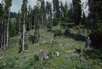
Title (German)
Zweisimmen BE, In der Versuchsfläche Grubenwald südwestlich von Unders Homad
Caption
West view of WSL experimental plot (with timber harvest) with windthrow litter damage at vegetation onset, 1st follow-up photograph 1993, secondary succession, ground vegetation and growing shrub layer, partial view; coordinates (LV03) of camera location: 597187/158375; keywords Documenta Natura: windthrow, mountain forest, afforestation, experimental forestation.
Caption (German)
Westansicht der WSL-Versuchsfläche (mit Holzernte) mit Windwurfstreuschaden bei Vegetationsbeginn, 1. Folgeaufnahme 1993, sekundäre Sukzession, Bodenvegetation und wachsende Strauchschicht, Teilansicht; Koordinaten (LV03) des Kamerastandorts: 597187/158375; Schlagworte Documenta Natura: Windwurf, Gebirgswald, Aufforstung, Versuchswaldung
Record Name
Dia_303-33570

Title (German)
Zweisimmen BE, In der Versuchsfläche Grubenwald südwestlich von Unders Homad
Caption
West view of WSL experimental plot (with timber harvest) with windthrow litter damage at vegetation onset, 2nd follow-up image 1994, secondary succession, ground vegetation and shrub layer, partial view; coordinates (LV03) of camera location: 597187/158375; keywords Documenta Natura: windthrow, mountain forest, afforestation, experimental forestation.
Caption (German)
Westansicht der WSL-Versuchsfläche (mit Holzernte) mit Windwurfstreuschaden bei Vegetationsbeginn, 2. Folgeaufnahme 1994, sekundäre Sukzession, Bodenvegetation und Strauchschicht, Teilansicht; Koordinaten (LV03) des Kamerastandorts: 597187/158375; Schlagworte Documenta Natura: Windwurf, Gebirgswald, Aufforstung, Versuchswaldung
Record Name
Dia_303-33594

Title (German)
Zweisimmen BE, In der Versuchsfläche Grubenwald südwestlich von Unders Homad
Caption
West view of WSL experimental plot (with timber harvest) with windthrow litter damage at vegetation onset, 3rd follow-up photograph 1997, secondary succession, ground vegetation, shrub layer, pioneer plants, partial view; coordinates (LV03) of camera location: 597187/158375; keywords Documenta Natura: windthrow, mountain forest, afforestation, experimental forestation.
Caption (German)
Westansicht der WSL-Versuchsfläche (mit Holzernte) mit Windwurfstreuschaden bei Vegetationsbeginn, 3. Folgeaufnahme 1997, sekundäre Sukzession, Bodenvegetation, Strauchschicht, Pionierpflanzen, Teilansicht; Koordinaten (LV03) des Kamerastandorts: 597187/158375; Schlagworte Documenta Natura: Windwurf, Gebirgswald, Aufforstung, Versuchswaldung
Record Name
Dia_303-33604

Title (German)
Zweisimmen BE, In der Versuchsfläche Grubenwald südwestlich von Unders Homad
Caption
West view of WSL experimental plot (with timber harvest) with windthrow litter damage at vegetation onset, 4th follow-up image 2000, secondary succession, ground vegetation, shrub layer, pioneer plants, partial view; coordinates (LV03) of camera location: 597187/158375; keywords Documenta Natura: windthrow, mountain forest, afforestation, experimental forestation.
Caption (German)
Westansicht der WSL-Versuchsfläche (mit Holzernte) mit Windwurfstreuschaden bei Vegetationsbeginn, 4. Folgeaufnahme 2000, sekundäre Sukzession, Bodenvegetation, Strauchschicht, Pionierpflanzen, Teilansicht; Koordinaten (LV03) des Kamerastandorts: 597187/158375; Schlagworte Documenta Natura: Windwurf, Gebirgswald, Aufforstung, Versuchswaldung
Record Name
Dia_303-33614

Title (German)
Zweisimmen BE, In der Versuchsfläche Grubenwald südwestlich von Unders Homad
Caption
Northeast view of WSL experimental plot (without storm-timber harvest) with windthrow litter damage at the onset of vegetation, first photograph taken in 1992, secondary succession, partial view; coordinates (LV03) of camera location: 597080/158132; keywords Documenta Natura: windthrow, mountain forest, reforestation, experimental forestation.
Caption (German)
Nordostansicht der WSL-Versuchsfläche (ohne Sturmholzernte) mit Windwurfstreuschaden bei Vegetationsbeginn, Erstaufnahme 1992, sekundäre Sukzession, Teilansicht; Koordinaten (LV03) des Kamerastandorts: 597080/158132; Schlagworte Documenta Natura: Windwurf, Gebirgswald, Aufforstung, Versuchswaldung
Record Name
Dia_303-33625

Title (German)
Zweisimmen BE, In der Versuchsfläche Grubenwald südwestlich von Unders Homad
Caption
Northeast view of WSL experimental plot (without storm-timber harvest) with windthrow litter damage and forced use (due to beetle infestation) at the onset of vegetation, 1st follow-up photograph 1993, secondary succession, growing shrub layer, partial view; coordinates (LV03) of camera location: 597080/158132; keywords Documenta Natura: windthrow, mountain forest, afforestation, experimental forestation.
Caption (German)
Nordostansicht der WSL-Versuchsfläche (ohne Sturmholzernte) mit Windwurfstreuschaden und Zwangsnutzung (wegen Käferbefall) bei Vegetationsbeginn, 1. Folgeaufnahme 1993, sekundäre Sukzession, wachsende Strauchschicht, Teilansicht; Koordinaten (LV03) des Kamerastandorts: 597080/158132; Schlagworte Documenta Natura: Windwurf, Gebirgswald, Aufforstung, Versuchswaldung
Record Name
Dia_303-33632

Title (German)
Zweisimmen BE, In der Versuchsfläche Grubenwald südwestlich von Unders Homad
Caption
Northeast view of WSL experimental plot (without storm-timber harvest) with windthrow litter damage at vegetation onset, 2nd follow-up image 1994, secondary succession, shrub layer and pioneer trees, partial view; coordinates (LV03) of camera location: 597080/158132; keywords Documenta Natura: windthrow, mountain forest, afforestation, experimental forestation.
Caption (German)
Nordostansicht der WSL-Versuchsfläche (ohne Sturmholzernte) mit Windwurfstreuschaden bei Vegetationsbeginn, 2. Folgeaufnahme 1994, sekundäre Sukzession, Strauchschicht und Pionierbäume, Teilansicht; Koordinaten (LV03) des Kamerastandorts: 597080/158132; Schlagworte Documenta Natura: Windwurf, Gebirgswald, Aufforstung, Versuchswaldung
Record Name
Dia_303-33644

Title (German)
Zweisimmen BE, In der Versuchsfläche Grubenwald südwestlich von Unders Homad
Caption
Northeast view of WSL experimental plot (without storm wood harvest) with windthrow litter damage at vegetation onset, 3rd follow-up photograph 1997, secondary succession, shrub layer and pioneer trees, partial view; coordinates (LV03) of camera location: 597080/158132; keywords Documenta Natura: windthrow, mountain forest, afforestation, experimental forestation.
Caption (German)
Nordostansicht der WSL-Versuchsfläche (ohne Sturmholzernte) mit Windwurfstreuschaden bei Vegetationsbeginn, 3. Folgeaufnahme 1997, sekundäre Sukzession, Strauchschicht und Pionierbäume, Teilansicht; Koordinaten (LV03) des Kamerastandorts: 597080/158132; Schlagworte Documenta Natura: Windwurf, Gebirgswald, Aufforstung, Versuchswaldung
Record Name
Dia_303-33654

Title (German)
Zweisimmen BE, In der Versuchsfläche Grubenwald südwestlich von Unders Homad
Caption
Northeast view of WSL experimental plot (without storm wood harvest) with windthrow litter damage at vegetation onset, 4th follow-up image 2000, secondary succession, shrub layer and pioneer trees, partial view; coordinates (LV03) of camera location: 597080/158132; keywords Documenta Natura: windthrow, mountain forest, afforestation, experimental forestation.
Caption (German)
Nordostansicht der WSL-Versuchsfläche (ohne Sturmholzernte) mit Windwurfstreuschaden bei Vegetationsbeginn, 4. Folgeaufnahme 2000, sekundäre Sukzession, Strauchschicht und Pionierbäume, Teilansicht; Koordinaten (LV03) des Kamerastandorts: 597080/158132; Schlagworte Documenta Natura: Windwurf, Gebirgswald, Aufforstung, Versuchswaldung
Record Name
Dia_303-33664

Title (German)
Zweisimmen BE, In der Versuchsfläche Grubenwald südwestlich von Unders Homad
Caption
South view of WSL experimental plot (without storm-timber harvest) with windthrow litter damage at the onset of vegetation, first photograph taken in 1992, secondary succession, partial view; coordinates (LV03) of camera location: 59697f/15826f; keywords Documenta Natura: windthrow, mountain forest, afforestation, experimental forestation.
Caption (German)
Südansicht der WSL-Versuchsfläche (ohne Sturmholzernte) mit Windwurfstreuschaden bei Vegetationsbeginn, Erstaufnahme 1992, sekundäre Sukzession, Teilansicht; Koordinaten (LV03) des Kamerastandorts: 59697f/15826f; Schlagworte Documenta Natura: Windwurf, Gebirgswald, Aufforstung, Versuchswaldung
Record Name
Dia_303-33676

Title (German)
Zweisimmen BE, In der Versuchsfläche Grubenwald südwestlich von Unders Homad
Caption
South view of WSL experimental plot (without storm-timber harvest) with windthrow litter damage at vegetation onset, 1st follow-up photograph 1993, secondary succession, ground vegetation, partial view; coordinates (LV03) of camera location: 59697f/15826f; keywords Documenta Natura: windthrow, mountain forest, reforestation, experimental forestation.
Caption (German)
Südansicht der WSL-Versuchsfläche (ohne Sturmholzernte) mit Windwurfstreuschaden bei Vegetationsbeginn, 1. Folgeaufnahme 1993, sekundäre Sukzession, Bodenvegetation, Teilansicht; Koordinaten (LV03) des Kamerastandorts: 59697f/15826f; Schlagworte Documenta Natura: Windwurf, Gebirgswald, Aufforstung, Versuchswaldung
Record Name
Dia_303-33691

Title (German)
Zweisimmen BE, In der Versuchsfläche Grubenwald südwestlich von Unders Homad
Caption
South view of WSL experimental plot (without storm-timber harvest) with windthrow litter damage at vegetation onset, 2nd follow-up photograph 1994, secondary succession, ground vegetation with shrub layer, partial view; coordinates (LV03) of camera location: 59697f/15826f; keywords Documenta Natura: windthrow, mountain forest, afforestation, experimental forestation.
Caption (German)
Südansicht der WSL-Versuchsfläche (ohne Sturmholzernte) mit Windwurfstreuschaden bei Vegetationsbeginn, 2. Folgeaufnahme 1994, sekundäre Sukzession, Bodenvegetation mit Strauchschicht, Teilansicht; Koordinaten (LV03) des Kamerastandorts: 59697f/15826f; Schlagworte Documenta Natura: Windwurf, Gebirgswald, Aufforstung, Versuchswaldung
Record Name
Dia_303-33703

Title (German)
Zweisimmen BE, In der Versuchsfläche Grubenwald südwestlich von Unders Homad
Caption
South view of WSL experimental plot (without storm-timber harvest) with windthrow litter damage at vegetation onset, 3rd follow-up photograph 1997, secondary succession, shrub layer, scattered pioneer trees, partial view; coordinates (LV03) of camera location: 59697f/15826f; keywords Documenta Natura: windthrow, mountain forest, afforestation, experimental forestation.
Caption (German)
Südansicht der WSL-Versuchsfläche (ohne Sturmholzernte) mit Windwurfstreuschaden bei Vegetationsbeginn, 3. Folgeaufnahme 1997, sekundäre Sukzession, Strauchschicht, vereinzelte Pionierbäume, Teilansicht; Koordinaten (LV03) des Kamerastandorts: 59697f/15826f; Schlagworte Documenta Natura: Windwurf, Gebirgswald, Aufforstung, Versuchswaldung
Record Name
Dia_303-33713

Title (German)
Zweisimmen BE, In der Versuchsfläche Grubenwald südwestlich von Unders Homad
Caption
West view of WSL experimental plot (without storm-timber harvest) with windthrow litter damage and later forced use (1997) at the onset of vegetation, first photograph taken in 1993, secondary succession, general view; coordinates (LV03) of camera location: 59707f/15826f; keywords Documenta Natura: windthrow, mountain forest, afforestation, experimental forestation.
Caption (German)
Westansicht der WSL-Versuchsfläche (ohne Sturmholzernte) mit Windwurfstreuschaden und späterer Zwangsnutzung (1997) bei Vegetationsbeginn, Erstaufnahme 1993, sekundäre Sukzession, Gesamtansicht; Koordinaten (LV03) des Kamerastandorts: 59707f/15826f; Schlagworte Documenta Natura: Windwurf, Gebirgswald, Aufforstung, Versuchswaldung
Record Name
Dia_303-33721

Title (German)
Zweisimmen BE, In der Versuchsfläche Grubenwald südwestlich von Unders Homad
Caption
West view of WSL experimental plot (without storm-timber harvest) with windthrow litter damage at vegetation onset, 1st follow-up photograph 1994, secondary succession, ground vegetation, general view; coordinates (LV03) of camera location: 59707f/15826f; keywords Documenta Natura: windthrow, mountain forest, reforestation, experimental forestation.
Caption (German)
Westansicht der WSL-Versuchsfläche (ohne Sturmholzernte) mit Windwurfstreuschaden bei Vegetationsbeginn, 1. Folgeaufnahme 1994, sekundäre Sukzession, Bodenvegetation, Gesamtansicht; Koordinaten (LV03) des Kamerastandorts: 59707f/15826f; Schlagworte Documenta Natura: Windwurf, Gebirgswald, Aufforstung, Versuchswaldung
Record Name
Dia_303-33731

Title (German)
Zweisimmen BE, In der Versuchsfläche Grubenwald südwestlich von Unders Homad
Caption
West view of WSL experimental plot (without storm-timber harvest) with windthrow litter damage at the beginning of vegetation, 2nd follow-up photograph 1997, secondary succession, shrub layer with pioneer trees, forced use occurred due to bark beetle infestation, general view; coordinates (LV03) of camera location: 59707f/15826f; keywords Documenta Natura: windthrow, mountain forest, reforestation, experimental forestation.
Caption (German)
Westansicht der WSL-Versuchsfläche (ohne Sturmholzernte) mit Windwurfstreuschaden bei Vegetationsbeginn, 2. Folgeaufnahme 1997, sekundäre Sukzession, Strauchschicht mit Pionierbäumen, erfolgte Zwangsnutzung wegen Borkenkäferbefall, Gesamtansicht; Koordinaten (LV03) des Kamerastandorts: 59707f/15826f; Schlagworte Documenta Natura: Windwurf, Gebirgswald, Aufforstung, Versuchswaldung
Record Name
Dia_303-33740

Title (German)
Zürich ZH, Grünanlage in Wohnsiedlung auf Gleisüberdeckung Zürich-Wipkingen
Caption
New green space with footpaths, playground and benches in newly built housing estate (Rötelsteig) on track overlay, first photo in spring, partial view towards south; keywords Documenta Natura: lowland, city, neighborhood, housing estate, park
Caption (German)
Neue Grünanlage mit Fusswegen, Spielplatz und Sitzbänken in neu erstellter Wohnsiedlung (Rötelsteig) auf Gleisüberdeckung, Erstaufnahme im Frühling, Teilansicht Richtung Süden; Schlagworte Documenta Natura: Flachland, Stadt, Quartier, Wohnsiedlung, Park
Record Name
Dia_303-33752

Title (German)
Zürich ZH, Grünanlage in Wohnsiedlung auf Gleisüberdeckung Zürich-Wipkingen
Caption
New green space with footpaths, playground and benches in newly built housing estate (Rötelsteig) on track overlay, first photo in spring, partial view towards south; keywords Documenta Natura: lowland, city, neighborhood, housing estate, park
Caption (German)
Neue Grünanlage mit Fusswegen, Spielplatz und Sitzbänken in neu erstellter Wohnsiedlung (Rötelsteig) auf Gleisüberdeckung, Erstaufnahme im Frühling, Teilansicht Richtung Süden; Schlagworte Documenta Natura: Flachland, Stadt, Quartier, Wohnsiedlung, Park
Record Name
Dia_303-33755

Title (German)
Zürich ZH, Grünanlage in Wohnsiedlung auf Gleisüberdeckung Zürich-Wipkingen
Caption
New green space with footpaths, playground and benches in newly built housing estate (Rötelsteig) on track overlay, first photo in spring, partial view towards south; keywords Documenta Natura: lowland, city, neighborhood, housing estate, park
Caption (German)
Neue Grünanlage mit Fusswegen, Spielplatz und Sitzbänken in neu erstellter Wohnsiedlung (Rötelsteig) auf Gleisüberdeckung, Erstaufnahme im Frühling, Teilansicht Richtung Süden; Schlagworte Documenta Natura: Flachland, Stadt, Quartier, Wohnsiedlung, Park
Record Name
Dia_303-33757

Title (German)
Zürich ZH, Grünanlage in Wohnsiedlung auf Gleisüberdeckung Zürich-Wipkingen
Caption
New green space with footpaths, playground and benches in newly built housing estate (Rötelsteig) on track overlay, first photo in spring, partial view towards south; keywords Documenta Natura: lowland, city, neighborhood, housing estate, park
Caption (German)
Neue Grünanlage mit Fusswegen, Spielplatz und Sitzbänken in neu erstellter Wohnsiedlung (Rötelsteig) auf Gleisüberdeckung, Erstaufnahme im Frühling, Teilansicht Richtung Süden; Schlagworte Documenta Natura: Flachland, Stadt, Quartier, Wohnsiedlung, Park
Record Name
Dia_303-33759

Title (German)
Zürich ZH, Grünanlage in Wohnsiedlung auf Gleisüberdeckung Zürich-Wipkingen
Caption
New green space with footpaths, playground and benches in newly built housing estate (Rötelsteig) on track overlay, first photo in spring, partial view towards south; keywords Documenta Natura: lowland, city, neighborhood, housing estate, park
Caption (German)
Neue Grünanlage mit Fusswegen, Spielplatz und Sitzbänken in neu erstellter Wohnsiedlung (Rötelsteig) auf Gleisüberdeckung, Erstaufnahme im Frühling, Teilansicht Richtung Süden; Schlagworte Documenta Natura: Flachland, Stadt, Quartier, Wohnsiedlung, Park
Record Name
Dia_303-33764

Title (German)
Zürich ZH, Grünanlage in Wohnsiedlung auf Gleisüberdeckung Zürich-Wipkingen
Caption
New green space with footpaths, playground and benches in newly built housing estate (Rötelsteig) on track overlay, first photo in spring, partial view towards south; keywords Documenta Natura: lowland, city, neighborhood, housing estate, park
Caption (German)
Neue Grünanlage mit Fusswegen, Spielplatz und Sitzbänken in neu erstellter Wohnsiedlung (Rötelsteig) auf Gleisüberdeckung, Erstaufnahme im Frühling, Teilansicht Richtung Süden; Schlagworte Documenta Natura: Flachland, Stadt, Quartier, Wohnsiedlung, Park
Record Name
Dia_303-33767

Title (German)
Zürich ZH, Grünanlage in Wohnsiedlung auf Gleisüberdeckung Zürich-Wipkingen
Caption
New green space with footpaths, playground and benches in newly built housing estate (Rötelsteig) on track overlay, first photo in spring, partial view to the north; keywords Documenta Natura: lowland, city, neighborhood, housing estate, park
Caption (German)
Neue Grünanlage mit Fusswegen, Spielplatz und Sitzbänken in neu erstellter Wohnsiedlung (Rötelsteig) auf Gleisüberdeckung, Erstaufnahme im Frühling, Teilansicht Richtung Norden; Schlagworte Documenta Natura: Flachland, Stadt, Quartier, Wohnsiedlung, Park
Record Name
Dia_303-33775

Title (German)
Zürich ZH, Grünanlage in Wohnsiedlung auf Gleisüberdeckung Zürich-Wipkingen
Caption
New green space with footpaths, playground and benches in newly built housing estate (Rötelsteig) on track overlay, first photo in spring, partial view to the north; keywords Documenta Natura: lowland, city, neighborhood, housing estate, park
Caption (German)
Neue Grünanlage mit Fusswegen, Spielplatz und Sitzbänken in neu erstellter Wohnsiedlung (Rötelsteig) auf Gleisüberdeckung, Erstaufnahme im Frühling, Teilansicht Richtung Norden; Schlagworte Documenta Natura: Flachland, Stadt, Quartier, Wohnsiedlung, Park
Record Name
Dia_303-33777

Title (German)
Zürich ZH, Grünanlage in Wohnsiedlung auf Gleisüberdeckung Zürich-Wipkingen
Caption
New green space with footpaths, playground and benches in newly built housing estate (Rötelsteig) on track overlay, photo taken in early summer, partial view to the north; keywords Documenta Natura: lowland, city, neighborhood, housing estate, park
Caption (German)
Neue Grünanlage mit Fusswegen, Spielplatz und Sitzbänken in neu erstellter Wohnsiedlung (Rötelsteig) auf Gleisüberdeckung, Aufnahme im Vorsommer, Teilansicht Richtung Norden; Schlagworte Documenta Natura: Flachland, Stadt, Quartier, Wohnsiedlung, Park
Record Name
Dia_303-33780

Title (German)
Zürich ZH, Grünanlage in Wohnsiedlung auf Gleisüberdeckung Zürich-Wipkingen
Caption
New green space with footpaths, playground and benches in newly built housing estate (Rötelsteig) on track overlay, photo taken in early summer, partial view facing south; keywords Documenta Natura: lowland, city, neighborhood, housing estate, park
Caption (German)
Neue Grünanlage mit Fusswegen, Spielplatz und Sitzbänken in neu erstellter Wohnsiedlung (Rötelsteig) auf Gleisüberdeckung, Aufnahme im Vorsommer, Teilansicht Richtung Süden; Schlagworte Documenta Natura: Flachland, Stadt, Quartier, Wohnsiedlung, Park
Record Name
Dia_303-33782

Title (German)
Zürich ZH, Grünanlage in Wohnsiedlung auf Gleisüberdeckung Zürich-Wipkingen
Caption
New green space with footpaths, playground and benches in newly built housing estate (Rötelsteig) on track overlay, photo taken in early summer, partial view facing south; keywords Documenta Natura: lowland, city, neighborhood, housing estate, park
Caption (German)
Neue Grünanlage mit Fusswegen, Spielplatz und Sitzbänken in neu erstellter Wohnsiedlung (Rötelsteig) auf Gleisüberdeckung, Aufnahme im Vorsommer, Teilansicht Richtung Süden; Schlagworte Documenta Natura: Flachland, Stadt, Quartier, Wohnsiedlung, Park
Record Name
Dia_303-33785

Title (German)
Zürich ZH, Grünanlage in Wohnsiedlung auf Gleisüberdeckung Zürich-Wipkingen
Caption
New green space with footpaths, playground and benches in newly built housing estate (Rötelsteig) on track overlay, photo taken in early summer, partial view to the north; keywords Documenta Natura: lowland, city, neighborhood, housing estate, park
Caption (German)
Neue Grünanlage mit Fusswegen, Spielplatz und Sitzbänken in neu erstellter Wohnsiedlung (Rötelsteig) auf Gleisüberdeckung, Aufnahme im Vorsommer, Teilansicht Richtung Norden; Schlagworte Documenta Natura: Flachland, Stadt, Quartier, Wohnsiedlung, Park
Record Name
Dia_303-33794

Title (German)
Zürich ZH, Grünanlage in Wohnsiedlung auf Gleisüberdeckung Zürich-Wipkingen
Caption
New green space with footpaths, playground and benches in newly built housing estate (Rötelsteig) on track overlay, photo taken in early summer, partial view to the north; keywords Documenta Natura: lowland, city, neighborhood, housing estate, park
Caption (German)
Neue Grünanlage mit Fusswegen, Spielplatz und Sitzbänken in neu erstellter Wohnsiedlung (Rötelsteig) auf Gleisüberdeckung, Aufnahme im Vorsommer, Teilansicht Richtung Norden; Schlagworte Documenta Natura: Flachland, Stadt, Quartier, Wohnsiedlung, Park
Record Name
Dia_303-33796

Title (German)
Zürich ZH, Grünanlage in Wohnsiedlung auf Gleisüberdeckung Zürich-Wipkingen
Caption
New green space with footpaths, playground and benches in newly built housing estate (Rötelsteig) on track overlay, photo taken in early summer, partial view facing south; keywords Documenta Natura: lowland, city, neighborhood, housing estate, park
Caption (German)
Neue Grünanlage mit Fusswegen, Spielplatz und Sitzbänken in neu erstellter Wohnsiedlung (Rötelsteig) auf Gleisüberdeckung, Aufnahme im Vorsommer, Teilansicht Richtung Süden; Schlagworte Documenta Natura: Flachland, Stadt, Quartier, Wohnsiedlung, Park
Record Name
Dia_303-33799

Title (German)
Koppigen BE, Nordwestliche Teil (Ostansicht) der Waldlichtung und Ackerlandschaft Lutermoos
Caption
Northwestern part of clearing and farmland Lutermoos with corridor road along the edge of the forest, partial view, panoramic view 2-part; coordinates (LV03) of the camera location: 612225/222235; keywords Documenta Natura: track construction, landscape change, lowland, farmland, clearing, forest edge forest aisle.
Caption (German)
Nordwestliche Teil der Waldlichtung und Ackerland Lutermoos mit Flurstrasse entlang des Waldrandes, Teilansicht, Panoramaaufnahme 2-teilig; Koordinaten (LV03) des Kamerastandorts: 612225/222235; Schlagworte Documenta Natura: Gleisbau, Landschaftswandel, Flachland, Ackerland, Rodung, Waldrand Waldschneise
Record Name
Dia_303-33811
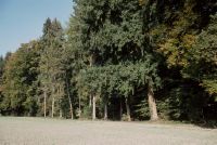
Title (German)
Koppigen BE, Nordwestliche Teil (Ostansicht) der Waldlichtung und Ackerlandschaft Lutermoos
Caption
Northwestern part of the clearing and farmland Lutermoos with corridor road along the edge of the forest, partial view, panoramic view 2-part; coordinates (LV03) of the camera location: 612225/222235; keywords Documenta Natura: track construction, landscape change, lowland, farmland, clearing, forest edge forest aisle.
Caption (German)
Nordwestliche Teil der Waldlichtung und Ackerland Lutermoos mit Flurstrasse entlang des Waldrandes, Teilansicht, Panoramaaufnahme 2-teilig; Koordinaten (LV03) des Kamerastandorts: 612225/222235; Schlagworte Documenta Natura: Gleisbau, Landschaftswandel, Flachland, Ackerland, Rodung, Waldrand Waldschneise
Record Name
Dia_303-33815

Title (German)
Koppigen BE, Nordwestliche Teil (Ostansicht, Südansicht) der Waldlichtung und Ackerlandschaft Lutermoos
Caption
Northwestern part of clearing and farmland Lutermoos with meadowland and dirt road along forest edge, first photograph before construction (1997), partial view; coordinates (LV03) of camera location: 612175/222175; keywords Documenta Natura: track construction, landscape change, lowland, farmland, clearing, forest edge forest aisle.
Caption (German)
Nordwestliche Teil der Waldlichtung und Ackerland Lutermoos mit Wiesland und Feldweg entlang des Waldrandes, Erstaufnahme vor dem Bau (1997), Teilansicht; Koordinaten (LV03) des Kamerastandorts: 612175/222175; Schlagworte Documenta Natura: Gleisbau, Landschaftswandel, Flachland, Ackerland, Rodung, Waldrand Waldschneise
Record Name
Dia_303-33821

Title (German)
Koppigen BE, Nordwestliche Teil (Ostansicht, Südansicht) der Waldlichtung und Ackerlandschaft Lutermoos
Caption
Northwestern part of clearing and farmland Lutermoos with meadowland and dirt road along forest edge, first photograph before construction (1997), partial view; coordinates (LV03) of camera location: 612175/222175; keywords Documenta Natura: track construction, landscape change, lowland, farmland, clearing, forest edge forest aisle.
Caption (German)
Nordwestliche Teil der Waldlichtung und Ackerland Lutermoos mit Wiesland und Feldweg entlang des Waldrandes, Erstaufnahme vor dem Bau (1997), Teilansicht; Koordinaten (LV03) des Kamerastandorts: 612175/222175; Schlagworte Documenta Natura: Gleisbau, Landschaftswandel, Flachland, Ackerland, Rodung, Waldrand Waldschneise
Record Name
Dia_303-33827

Title (German)
Langenthal BE, Südansicht der Weide Unterhard mit Hügeln (Keltengräber) und der Bahnlinie der SBB
Caption
South view of the meadow Unterhard with copses (Celtic graves) and road, in the background the village Mumenthal (partly), before construction (1998), partial view; coordinates (LV03) of the camera location: 626345/231025; keywords Documenta Natura: track construction, landscape change, lowland, farmland, clearing, edge of forest forest aisle
Caption (German)
Südansicht des Wieslandes Unterhard mit Gehölzen (Keltengräber) und Strasse, im Hintergrund das Dorf Mumenthal (teilweise), vor dem Bau (1998), Teilansicht; Koordinaten (LV03) des Kamerastandorts: 626345/231025; Schlagworte Documenta Natura: Gleisbau, Landschaftswandel, Flachland, Ackerland, Rodung, Waldrand Waldschneise
Record Name
Dia_303-33833

Title (German)
Langenthal, Thunstetten BE, Kulturlandschaft Wolfhusen (Westansicht, Südansicht) westlich von Langenthal
Caption
Cultivated landscape with meadowland, tree nursery, arable land, in the background forest edge, cantonal road 1 (Langenthal-Bützberg), photograph taken before construction (1998), partial view; coordinates (LV03) of camera location: 624850/229678; keywords Documenta Natura: track construction, landscape change, lowland, arable land, clearing, forest edge forest aisle.
Caption (German)
Kulturlandschaft mit Wiesland, Baumschule, Ackerland, im Hintergrund Waldrand, Kantonsstrasse 1 (Langenthal-Bützberg), Aufnahme vor dem Bau (1998), Teilansicht; Koordinaten (LV03) des Kamerastandorts: 624850/229678; Schlagworte Documenta Natura: Gleisbau, Landschaftswandel, Flachland, Ackerland, Rodung, Waldrand Waldschneise
Record Name
Dia_303-33846

Title (German)
Langenthal, Thunstetten BE, Kulturlandschaft Wolfhusen (Westansicht, Südansicht) westlich von Langenthal
Caption
Cultivated landscape with meadowland, tree nursery, arable land, in the background forest edge, cantonal road 1 (Langenthal-Bützberg), photograph taken before construction (1998), partial view; coordinates (LV03) of camera location: 624850/229678; keywords Documenta Natura: track construction, landscape change, lowland, arable land, clearing, forest edge forest aisle.
Caption (German)
Kulturlandschaft mit Wiesland, Baumschule, Ackerland, im Hintergrund Waldrand, Kantonsstrasse 1 (Langenthal-Bützberg), Aufnahme vor dem Bau (1998), Teilansicht; Koordinaten (LV03) des Kamerastandorts: 624850/229678; Schlagworte Documenta Natura: Gleisbau, Landschaftswandel, Flachland, Ackerland, Rodung, Waldrand Waldschneise
Record Name
Dia_303-33856

Title (German)
Langenthal, Thunstetten BE, Kulturlandschaft Wolfhusen (Westansicht, Südansicht) westlich von Langenthal
Caption
Cultural landscape with meadowland, tree nursery, farmland, cantonal road 1 (Langenthal-Bützberg), 1st follow-up photograph after 4 years during the construction of the railroad line (Neunbahnstrecke) of the SBB (still without railroad technology) with bridge and underpass (2002), partial view; coordinates (LV03) of the camera location: 624850/229678; keywords Documenta Natura: track construction, landscape change, lowland, farmland, clearing, edge of forest forest aisle
Caption (German)
Kulturlandschaft mit Wiesland, Baumschule, Ackerland, Kantonsstrasse 1 (Langenthal-Bützberg), 1. Folgeaufnahme nach 4 Jahren während dem Bau der Bahnlinie (Neunbahnstrecke) der SBB (noch ohne Bahntechnik) mit Brücke und Unterführung (2002), Teilansicht; Koordinaten (LV03) des Kamerastandorts: 624850/229678; Schlagworte Documenta Natura: Gleisbau, Landschaftswandel, Flachland, Ackerland, Rodung, Waldrand Waldschneise
Record Name
Dia_303-33866

Title (German)
Langenthal, Thunstetten BE, Kulturlandschaft Wolfhusen (Westansicht, Südansicht) westlich von Langenthal
Caption
Cultural landscape with meadowland, tree nursery, farmland, cantonal road 1 (Langenthal-Bützberg), 1st follow-up photograph after 4 years during the construction of the railroad line (Neunbahnstrecke) of the SBB (still without railroad technology) with bridge and underpass (2002), partial view; coordinates (LV03) of the camera location: 624850/229678; keywords Documenta Natura: track construction, landscape change, lowland, farmland, clearing, edge of forest forest aisle
Caption (German)
Kulturlandschaft mit Wiesland, Baumschule, Ackerland, Kantonsstrasse 1 (Langenthal-Bützberg), 1. Folgeaufnahme nach 4 Jahren während dem Bau der Bahnlinie (Neunbahnstrecke) der SBB (noch ohne Bahntechnik) mit Brücke und Unterführung (2002), Teilansicht; Koordinaten (LV03) des Kamerastandorts: 624850/229678; Schlagworte Documenta Natura: Gleisbau, Landschaftswandel, Flachland, Ackerland, Rodung, Waldrand Waldschneise
Record Name
Dia_303-33876

Title (German)
Roggwil BE, Kulturlandschaft Im Löli (Nordostansicht) östlich von Mumenthal
Caption
Cultural landscape Im Löli with parallel cantonal road (Langenthal-Roggwil) and railroad line of the RVO, railroad line of the SBB (trunk line) and Brunnbach with trees, photograph taken before construction (1998), partial view; coordinates (LV03) of camera location: 626875/231875; keywords Documenta Natura: track construction, landscape change, lowland, farmland, clearing, edge of forest forest aisle
Caption (German)
Kulturlandschaft Im Löli mit paralleler Kantonsstrasse (Langenthal-Roggwil) und Bahnlinie der RVO, Bahnlinie der SBB (Stammlinie) und Brunnbach mit Baumbestand, Aufnahme vor dem Bau (1998), Teilansicht; Koordinaten (LV03) des Kamerastandorts: 626875/231875; Schlagworte Documenta Natura: Gleisbau, Landschaftswandel, Flachland, Ackerland, Rodung, Waldrand Waldschneise
Record Name
Dia_303-33888

Title (German)
Roggwil BE, Kulturlandschaft Im Löli (Nordostansicht) östlich von Mumenthal
Caption
Cultural landscape Im Löli with parallel cantonal road (Langenthal-Roggwil) and railroad line of the RVO, railroad line of the SBB (trunk line) and Brunnbach with trees, photograph taken before construction (1998), partial view; coordinates (LV03) of camera location: 626875/231875; keywords Documenta Natura: track construction, landscape change, lowland, farmland, clearing, edge of forest forest aisle
Caption (German)
Kulturlandschaft Im Löli mit paralleler Kantonsstrasse (Langenthal-Roggwil) und Bahnlinie der RVO, Bahnlinie der SBB (Stammlinie) und Brunnbach mit Baumbestand, Aufnahme vor dem Bau (1998), Teilansicht; Koordinaten (LV03) des Kamerastandorts: 626875/231875; Schlagworte Documenta Natura: Gleisbau, Landschaftswandel, Flachland, Ackerland, Rodung, Waldrand Waldschneise
Record Name
Dia_303-33900

Title (German)
Aarwangen BE, Kulturlandschaft (Nordostansichten) östlich von Hof, Mumenthal
Caption
Cultural landscape with arable land (grain field), hedges and stream with bushes and reeds, in the background the village part Hof, photo spring 1998, partial view; coordinates (LV03) of the camera location: 626515/232433; keywords Documenta Natura: track construction, landscape change, lowland, arable land, clearing, forest edge forest aisle.
Caption (German)
Kulturlandschaft mit Ackerland (Getreidefeld), Hecken und Bachlauf mit Gebüschen und Schilf, im Hintergrund der Dorfteil Hof, Aufnahme Frühling 1998, Teilansicht; Koordinaten (LV03) des Kamerastandorts: 626515/232433; Schlagworte Documenta Natura: Gleisbau, Landschaftswandel, Flachland, Ackerland, Rodung, Waldrand Waldschneise
Record Name
Dia_303-33909

Title (German)
Aarwangen BE, Kulturlandschaft (Nordostansichten) östlich von Hof, Mumenthal
Caption
Cultural landscape with arable land (grain field), hedges and stream with bushes and reeds, in the background the village part Hof, photo spring 1998, general view; coordinates (LV03) of the camera location: 626663/232488; keywords Documenta Natura: track construction, landscape change, lowland, arable land, clearing, forest edge forest aisle.
Caption (German)
Kulturlandschaft mit Ackerland (Getreidefeld), Hecken und Bachlauf mit Gebüschen und Schilf, im Hintergrund der Dorfteil Hof, Aufnahme Frühling 1998, Gesamtansicht; Koordinaten (LV03) des Kamerastandorts: 626663/232488; Schlagworte Documenta Natura: Gleisbau, Landschaftswandel, Flachland, Ackerland, Rodung, Waldrand Waldschneise
Record Name
Dia_303-33919

Title (German)
Roggwil BE, Brunnbach und Wässermatten Brunnmatten nördlich der Siedlung Weibelacher
Caption
Brunnbach in the Wässermatten Brunnmatten with forest edge, meadowland, stream course with obstructions and with trees, in the background railroad line of the SBB (trunk line), first photo (1998), partial view; coordinates (LV03) of the camera location: 627660/232845; keywords Documenta Natura: track construction, landscape change, lowland, farmland, clearing, forest edge forest aisle
Caption (German)
Brunnbach in der Wässermatten Brunnmatten mit Waldrand, Wiesland, Bachlauf mit Verbauungen und mit Baumbestand, im Hintergrund Bahnlinie der SBB (Stammlinie), Erstaufnahme (1998), Teilansicht; Koordinaten (LV03) des Kamerastandorts: 627660/232845; Schlagworte Documenta Natura: Gleisbau, Landschaftswandel, Flachland, Ackerland, Rodung, Waldrand Waldschneise
Record Name
Dia_303-33932

Title (German)
Roggwil BE, Brunnbach und Wässermatten Brunnmatten nördlich der Siedlung Weibelacher
Caption
Brunnbach in the Wässermatten Brunnmatten with forest edge, meadowland, stream course with obstructions and with trees, in the background railroad line of the SBB (trunk line), first photo (1998), partial view; coordinates (LV03) of the camera location: 627661/232847; keywords Documenta Natura: track construction, landscape change, lowland, farmland, clearing, forest edge forest aisle
Caption (German)
Brunnbach in der Wässermatten Brunnmatten mit Waldrand, Wiesland, Bachlauf mit Verbauungen und mit Baumbestand, im Hintergrund Bahnlinie der SBB (Stammlinie), Erstaufnahme (1998), Teilansicht; Koordinaten (LV03) des Kamerastandorts: 627661/232847; Schlagworte Documenta Natura: Gleisbau, Landschaftswandel, Flachland, Ackerland, Rodung, Waldrand Waldschneise
Record Name
Dia_303-33943
Title (German)
Roggwil BE, Brunnbach und Wässermatten Brunnmatten nördlich der Siedlung Weibelacher
Caption
Brunnbach in the Wässermatten Brunnmatten with forest edge, meadowland, stream course with obstructions and with tree population, 1st follow-up photograph after 4 years (2002) during the construction of the new railway line, with noise protection dam in the shell, partial view; coordinates (LV03) of the camera location: 627660/232845; keywords Documenta Natura: track construction, landscape change, lowland, farmland, clearing, forest edge forest corridor
Caption (German)
Brunnbach in der Wässermatten Brunnmatten mit Waldrand, Wiesland, Bachlauf mit Verbauungen und mit Baumbestand, 1. Folgeaufnahme nach 4 Jahren (2002) während dem Bau der Neubahnstrecke, mit Lärmschutzdamm im Rohbau, Teilansicht; Koordinaten (LV03) des Kamerastandorts: 627660/232845; Schlagworte Documenta Natura: Gleisbau, Landschaftswandel, Flachland, Ackerland, Rodung, Waldrand Waldschneise
Record Name
Dia_303-33952
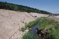
Title (German)
Roggwil BE, Brunnbach und Wässermatten Brunnmatten nördlich der Siedlung Weibelacher
Caption
Brunnbach in the Wässermatten Brunnmatten with forest edge, meadowland, stream course with obstructions and with tree population, 1st follow-up photograph after 4 years (2002) during the construction of the new railway line, with noise protection dam in the shell, partial view; coordinates (LV03) of the camera location: 627661/232847; keywords Documenta Natura: track construction, landscape change, lowland, farmland, clearing, forest edge forest corridor
Caption (German)
Brunnbach in der Wässermatten Brunnmatten mit Waldrand, Wiesland, Bachlauf mit Verbauungen und mit Baumbestand, 1. Folgeaufnahme nach 4 Jahren (2002) während dem Bau der Neubahnstrecke, mit Lärmschutzdamm im Rohbau, Teilansicht; Koordinaten (LV03) des Kamerastandorts: 627661/232847; Schlagworte Documenta Natura: Gleisbau, Landschaftswandel, Flachland, Ackerland, Rodung, Waldrand Waldschneise
Record Name
Dia_303-33962

Title (German)
Roggwil BE, Südostansicht der Wässermatten Brunnmatten westlich der Siedlung Weibelacher
Caption
View of Wässermatten Brunnmatten with meadowland, roadway and stream with trees, in the background railroad line of the SBB (trunk line), first photo (1998), partial view; coordinates (LV03) of the camera location: 627463/232600; keywords Documenta Natura: track construction, landscape change, lowland, farmland, clearing, forest edge forest corridor
Caption (German)
Ansicht der Wässermatten Brunnmatten mit Wiesland, Fahrweg und Bachlauf mit Baumbestand, im Hintergrund Bahnlinie der SBB (Stammlinie), Erstaufnahme (1998), Teilansicht; Koordinaten (LV03) des Kamerastandorts: 627463/232600; Schlagworte Documenta Natura: Gleisbau, Landschaftswandel, Flachland, Ackerland, Rodung, Waldrand Waldschneise
Record Name
Dia_303-33976

Title (German)
Roggwil BE, Südostansicht der Wässermatten Brunnmatten westlich der Siedlung Weibelacher
Caption
View of Wässermatten Brunnmatten with meadowland, roadway and stream with trees, in the background railroad line of the SBB (trunk line), first photo (1998), partial view; coordinates (LV03) of the camera location: 627463/232600; keywords Documenta Natura: track construction, landscape change, lowland, farmland, clearing, forest edge forest corridor
Caption (German)
Ansicht der Wässermatten Brunnmatten mit Wiesland, Fahrweg und Bachlauf mit Baumbestand, im Hintergrund Bahnlinie der SBB (Stammlinie), Erstaufnahme (1998), Teilansicht; Koordinaten (LV03) des Kamerastandorts: 627463/232600; Schlagworte Documenta Natura: Gleisbau, Landschaftswandel, Flachland, Ackerland, Rodung, Waldrand Waldschneise
Record Name
Dia_303-33987

Title (German)
Roggwil, Wynau BE, Wässermatten Brunnmatten nördlich der Siedlung Weibelacher Weibelacher
Caption
Northwest view of Wässermatten Brunnmatten, with stream and farmland, first photograph (1998), partial view; coordinates (LV03) of camera location: 627541/232949; keywords Documenta Natura: track construction, landscape change, lowland, farmland, clearing, forest edge forest aisle.
Caption (German)
Nordwestansicht der Wässermatten Brunnmatten, mit Bachlauf und Ackerland, Erstaufnahme (1998), Teilansicht; Koordinaten (LV03) des Kamerastandorts: 627541/232949; Schlagworte Documenta Natura: Gleisbau, Landschaftswandel, Flachland, Ackerland, Rodung, Waldrand Waldschneise
Record Name
Dia_303-33999

Title (German)
Roggwil, Wynau BE, Wässermatten Brunnmatten nördlich der Siedlung Weibelacher Weibelacher
Caption
Northwest view of the Wässermatten Brunnmatten, 1st follow-up photograph after 4 years during the construction of the new railway line of the SBB (2002), partial view; coordinates (LV03) of the camera location: 627541/232949; keywords Documenta Natura: track construction, landscape change, lowland, farmland, clearing, forest edge forest aisle.
Caption (German)
Nordwestansicht der Wässermatten Brunnmatten, 1. Folgeaufnahme nach 4 Jahren während dem Bau der Neubahnstrecke der SBB (2002), Teilansicht; Koordinaten (LV03) des Kamerastandorts: 627541/232949; Schlagworte Documenta Natura: Gleisbau, Landschaftswandel, Flachland, Ackerland, Rodung, Waldrand Waldschneise
Record Name
Dia_303-34009

Title (German)
Aarwangen BE, Westansicht des Wieslandes beim Naturschutzgebiet Muemetaler Weier östlich von Hof, Mumenthal
Caption
West view of extensive meadowland, in the background the nature reserve with the Muemethal pond and copses, first photograph (1998), partial view; coordinates (LV03) of the camera location: 626664/232480; keywords Documenta Natura: track construction, landscape change, lowland, farmland, clearing, forest edge forest aisle.
Caption (German)
Westansicht des extensiven Wieslandes, im Hintergrund das Naturschutzgebiet mit dem Muemethaler Weiher und Gehölz, Erstaufnahme (1998), Teilansicht; Koordinaten (LV03) des Kamerastandorts: 626664/232480; Schlagworte Documenta Natura: Gleisbau, Landschaftswandel, Flachland, Ackerland, Rodung, Waldrand Waldschneise
Record Name
Dia_303-34022

Title (German)
Wynau BE, Bahntrassee der SBB in der Wässermatten Brunnmatten
Caption
Northeast view of the track, embankment of the railroad line of the SBB, double track, embankment with isolated deciduous trees/single tree and bushes, in the background the Wässermatten, first photograph (1998), partial view; coordinates (LV03) of the camera location: 627575/232975; keywords Documenta Natura: track construction, landscape change, lowland, farmland, clearing, forest edge forest aisle.
Caption (German)
Nordostansicht des Trassees, Damms der Bahnlinie der SBB, Doppelspur, Böschung mit vereinzelten Laubbäumen/Einzelbaum und Gebüschen, im Hintergrund die Wässermatten, Erstaufnahme (1998), Teilansicht; Koordinaten (LV03) des Kamerastandorts: 627575/232975; Schlagworte Documenta Natura: Gleisbau, Landschaftswandel, Flachland, Ackerland, Rodung, Waldrand Waldschneise
Record Name
Dia_303-34034
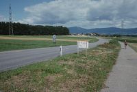
Title (German)
Aeschi, Bolken, Etziken SO, Südostansicht des Buechlisacher und Längacher nördlich von Aeschi mit der Kantonsstrasse
Caption
View of the farmland Buechlisacher and Längacher with the cantonal road (Herzogenbuchsee-Solothurn) and separate bicycle path, footpath, view direction Jura with the villages Etziken and Bolken, first photo (1998), partial view; coordinates (LV03) of the camera location: 616694/225805; keywords Documenta Natura: track construction, landscape change, lowland, farmland, clearing, forest edge forest aisle
Caption (German)
Ansicht des Ackerlandes Buechlisacher und Längacher mit der Kantonsstrasse (Herzogenbuchsee-Solothurn) und separatem Veloweg, Fussweg, Blickrichtung Jura mit den Dörfer Etziken und Bolken, Erstaufnahme (1998), Teilansicht; Koordinaten (LV03) des Kamerastandorts: 616694/225805; Schlagworte Documenta Natura: Gleisbau, Landschaftswandel, Flachland, Ackerland, Rodung, Waldrand Waldschneise
Record Name
Dia_303-34041

Title (German)
Aeschi, Bolken, Etziken SO, Südostansicht des Buechlisacher und Längacher nördlich von Aeschi mit der Kantonsstrasse
Caption
View of the farmland Buechlisacher and Längacher with the cantonal road (Herzogenbuchsee-Solothurn) and separate bicycle path, footpath, view direction Jura with the villages Etziken and Bolken, first photo (1998), partial view; coordinates (LV03) of the camera location: 616694/225805; keywords Documenta Natura: track construction, landscape change, lowland, farmland, clearing, forest edge forest aisle
Caption (German)
Ansicht des Ackerlandes Buechlisacher und Längacher mit der Kantonsstrasse (Herzogenbuchsee-Solothurn) und separatem Veloweg, Fussweg, Blickrichtung Jura mit den Dörfer Etziken und Bolken, Erstaufnahme (1998), Teilansicht; Koordinaten (LV03) des Kamerastandorts: 616694/225805; Schlagworte Documenta Natura: Gleisbau, Landschaftswandel, Flachland, Ackerland, Rodung, Waldrand Waldschneise
Record Name
Dia_303-34051

Title (German)
Aeschi, Bolken, Etziken SO, Südostansicht des Buechlisacher und Längacher nördlich von Aeschi mit der Kantonsstrasse
Caption
View of the farmland Buechlisacher and Längacher with the cantonal road (Herzogenbuchsee-Solothurn), looking towards Jura with the villages Etziken and Bolken, 1st photo. Follow-up photograph after 4 years during the construction of the new line of the SBB, with tunnel construction in surface mining, earth mound and temporary road bridge (2002), partial view; coordinates (LV03) of the camera location: 616694/225805; keywords Documenta Natura: track construction, landscape change, lowland, farmland, clearing, edge of forest forest aisle
Caption (German)
Ansicht des Ackerlandes Buechlisacher und Längacher mit der Kantonsstrasse (Herzogenbuchsee-Solothurn), Blickrichtung Jura mit den Dörfer Etziken und Bolken, 1. Folgeaufnahme nach 4 Jahren während dem Bau der Neubaustrecke der SBB, mit Tunnelbau im Tagbau, Erdhügel und provisorischer Strassenbrücke (2002), Teilansicht; Koordinaten (LV03) des Kamerastandorts: 616694/225805; Schlagworte Documenta Natura: Gleisbau, Landschaftswandel, Flachland, Ackerland, Rodung, Waldrand Waldschneise
Record Name
Dia_303-34061

Title (German)
Aeschi, Bolken, Etziken SO, Südostansicht des Buechlisacher und Längacher nördlich von Aeschi mit der Kantonsstrasse
Caption
View of the farmland Buechlisacher and Längacher with the cantonal road (Herzogenbuchsee-Solothurn), looking towards Jura with the villages Etziken and Bolken, 1st photo. Follow-up photo after 4 years during the construction of the new line of the SBB, with tunnel construction in surface mining, earth mound and temporary road bridge (2002), partial view; coordinates (LV03) of the camera location: 616694/225805; keywords Documenta Natura: track construction, landscape change, lowland, farmland, clearing, forest edge forest aisle
Caption (German)
Ansicht des Ackerlandes Buechlisacher und Längacher mit der Kantonsstrasse (Herzogenbuchsee-Solothurn), Blickrichtung Jura mit den Dörfer Etziken und Bolken, 1. Folgeaufnahme nach 4 Jahren während dem Bau der Neubaustrecke der SBB, mit Tunnelbau im Tagbau, Erdhügel und provisorischer Strassenbrücke (2002), Teilansicht; Koordinaten (LV03) des Kamerastandorts: 616694/225805; Schlagworte Documenta Natura: Gleisbau, Landschaftswandel, Flachland, Ackerland, Rodung, Waldrand Waldschneise
Record Name
Dia_303-34071

Title (German)
Aeschi, Bolken SO, Südwestansicht des Längacher nördlich von Aeschi mit der Kantonsstrasse
Caption
Southwest view of Längacher farmland, in the background the village of Bolken, first photograph (1998), partial view; coordinates (LV03) of camera location: 616652/225882; keywords Documenta Natura: track construction, landscape change, lowland, farmland, clearing, forest edge forest aisle.
Caption (German)
Südwestansicht des Ackerlandes Längacher, im Hintergrund das Dorf Bolken, Erstaufnahme (1998), Teilansicht; Koordinaten (LV03) des Kamerastandorts: 616652/225882; Schlagworte Documenta Natura: Gleisbau, Landschaftswandel, Flachland, Ackerland, Rodung, Waldrand Waldschneise
Record Name
Dia_303-34083

Title (German)
Aeschi, Bolken SO, Südwestansicht des Längacher nördlich von Aeschi mit der Kantonsstrasse
Caption
Southwest view of Längacher farmland, in the background the village of Bolken, 1st follow-up photograph taken during the construction of the new SBB railway line, with tunneling in surface mining (2002), partial view; coordinates (LV03) of the camera location: 616652/225882; keywords Documenta Natura: track construction, landscape change, lowland, farmland, clearing, forest edge forest aisle.
Caption (German)
Südwestansicht des Ackerlandes Längacher, im Hintergrund das Dorf Bolken, 1. Folgeaufnahme während dem Bau der Neubahnstrecke der SBB, mit Tunnelbau im Tagbau (2002), Teilansicht; Koordinaten (LV03) des Kamerastandorts: 616652/225882; Schlagworte Documenta Natura: Gleisbau, Landschaftswandel, Flachland, Ackerland, Rodung, Waldrand Waldschneise
Record Name
Dia_303-34092

Title (German)
Herzogenbuchsee BE, Im Wald/Waldschneise Unterwald nordöstlich von Reckeberg
Caption
In forest clearing northeast of Reckeberg with forest roads, first photograph (1998), partial view; coordinates (LV03) of camera location: 620300/227640; keywords Documenta Natura: track construction, landscape change, lowland, farmland, clearing, forest edge forest aisle.
Caption (German)
In Waldlichtung nordöstlich von Reckeberg mit Waldstrassen, Erstaufnahme (1998), Teilansicht; Koordinaten (LV03) des Kamerastandorts: 620300/227640; Schlagworte Documenta Natura: Gleisbau, Landschaftswandel, Flachland, Ackerland, Rodung, Waldrand Waldschneise
Record Name
Dia_303-34103

Title (German)
Herzogenbuchsee BE, Im Wald/Waldschneise Unterwald nordöstlich von Reckeberg
Caption
In forest clearing northeast of Reckeberg with forest roads, first photograph (1998), partial view; coordinates (LV03) of camera location: 620300/227640; keywords Documenta Natura: track construction, landscape change, lowland, farmland, clearing, forest edge forest aisle.
Caption (German)
In Waldlichtung nordöstlich von Reckeberg mit Waldstrassen, Erstaufnahme (1998), Teilansicht; Koordinaten (LV03) des Kamerastandorts: 620300/227640; Schlagworte Documenta Natura: Gleisbau, Landschaftswandel, Flachland, Ackerland, Rodung, Waldrand Waldschneise
Record Name
Dia_303-34114

Title (German)
Herzogenbuchsee BE, Im Wald/Waldschneise Unterwald nordöstlich von Reckeberg
Caption
Southeast view from the edge of the embankment over the track of the new railroad line, railroad line of the SBB, 1st follow-up photo after 4 years during construction with portal zone in cut-and-cover, temporary pedestrian bridge (2002), partial view; coordinates (LV03) of the camera location: 620300/227640; keywords Documenta Natura: track construction, landscape change, lowland, farmland, clearing, forest edge forest aisle
Caption (German)
Südostansicht vom Böschungsrand über das Trassee der Neubahnstrecke, Bahnlinie der SBB, 1. Folgeaufnahme nach 4 Jahren während dem Bau mit Portalzone im Tagbau, provisorischer Fussgängerbrücke (2002), Teilansicht; Koordinaten (LV03) des Kamerastandorts: 620300/227640; Schlagworte Documenta Natura: Gleisbau, Landschaftswandel, Flachland, Ackerland, Rodung, Waldrand Waldschneise
Record Name
Dia_303-34123

Title (German)
Herzogenbuchsee BE, Im Wald/Waldschneise Unterwald nordöstlich von Reckeberg
Caption
Southeast view from the edge of the embankment over the track of the new railroad line, railroad line of the SBB, 1st follow-up photo after 4 years during construction with portal zone in cut-and-cover, temporary pedestrian bridge (2002), partial view; coordinates (LV03) of the camera location: 620300/227640; keywords Documenta Natura: track construction, landscape change, lowland, farmland, clearing, forest edge forest aisle
Caption (German)
Südostansicht vom Böschungsrand über das Trassee der Neubahnstrecke, Bahnlinie der SBB, 1. Folgeaufnahme nach 4 Jahren während dem Bau mit Portalzone im Tagbau, provisorischer Fussgängerbrücke (2002), Teilansicht; Koordinaten (LV03) des Kamerastandorts: 620300/227640; Schlagworte Documenta Natura: Gleisbau, Landschaftswandel, Flachland, Ackerland, Rodung, Waldrand Waldschneise
Record Name
Dia_303-34128

Title (German)
Herzogenbuchsee BE, Im Wald Unterwald nördlich von Reckeberg
Caption
In the forest north of Reckeberg (Unterwald) with forest road, photograph taken in summer 1998, partial view; coordinates (LV03) of camera location: 620158/227650; keywords Documenta Natura: track construction, landscape change, lowland, farmland, clearing, forest edge forest aisle
Caption (German)
Im Wald nördlich von Reckeberg (Unterwald) mit Waldstrasse, Aufnahme Sommer 1998, Teilansicht; Koordinaten (LV03) des Kamerastandorts: 620158/227650; Schlagworte Documenta Natura: Gleisbau, Landschaftswandel, Flachland, Ackerland, Rodung, Waldrand Waldschneise
Record Name
Dia_303-34136

Title (German)
Koppigen BE, Nordwestliche Teil (Nordostansicht) der Waldlichtung und Ackerlandschaft Lutermoos
Caption
Northeast view of the forest clearing and farmland Lutermoos with corridor road along the forest edge and cleared forest aisle for the new railroad line of the Bahn 2000, photo spring 1999, partial view; coordinates (LV03) of the camera location: 61230f/222270; keywords Documenta Natura: track construction, landscape change, lowland, farmland, clearing, forest edge forest aisle
Caption (German)
Nordostansicht der Waldlichtung und Ackerland Lutermoos mit Flurstrasse entlang des Waldrandes und gerodeter Waldschneise für die Neubahnstrecke der Bahn 2000, Aufnahme Frühling 1999, Teilansicht; Koordinaten (LV03) des Kamerastandorts: 61230f/222270; Schlagworte Documenta Natura: Gleisbau, Landschaftswandel, Flachland, Ackerland, Rodung, Waldrand Waldschneise
Record Name
Dia_303-34146

Title (German)
Hersiwil, Oekingen SO, Ostansicht, Südansicht der Weiermatten, im Hintergrund der Weiler Rütihof
Caption
East view of the farmland and pasture landscape Weiermatten, in the background the hamlet Rütihof, first photograph (1999), partial view; coordinates (LV03) of the camera location: 615098/224245; keywords Documenta Natura: track construction, landscape change, lowland, farmland, clearing, forest edge forest aisle.
Caption (German)
Ostansicht der Ackerlandschaft und Weidelandschaft Weiermatten, im Hintergrund der Weiler Rütihof, Erstaufnahme (1999), Teilansicht; Koordinaten (LV03) des Kamerastandorts: 615098/224245; Schlagworte Documenta Natura: Gleisbau, Landschaftswandel, Flachland, Ackerland, Rodung, Waldrand Waldschneise
Record Name
Dia_303-34157

Title (German)
Hersiwil, Oekingen SO, Ostansicht, Südansicht der Weiermatten, im Hintergrund der Weiler Rütihof
Caption
South view of the farmland and pasture landscape Weiermatten, in the background the hamlet Rütihof, first photograph (1999), partial view; coordinates (LV03) of the camera location: 615098/224245; keywords Documenta Natura: track construction, landscape change, lowland, farmland, clearing, forest edge forest aisle.
Caption (German)
Südansicht der Ackerlandschaft und Weidelandschaft Weiermatten, im Hintergrund der Weiler Rütihof, Erstaufnahme (1999), Teilansicht; Koordinaten (LV03) des Kamerastandorts: 615098/224245; Schlagworte Documenta Natura: Gleisbau, Landschaftswandel, Flachland, Ackerland, Rodung, Waldrand Waldschneise
Record Name
Dia_303-34167
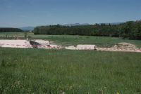
Title (German)
Hersiwil, Oekingen SO, Ostansicht, Südansicht der Weiermatten, im Hintergrund der Weiler Rütihof
Caption
East view of arable landscape, pasture landscape Weiermatten, in the background the hamlet Rütihof, 1st follow-up photograph after 3 years during the construction of the new railway line of the SBB, with tunnel and tunnel portal in surface mining (2002), partial view; coordinates (LV03) of the camera location: 615098/224245; keywords Documenta Natura: track construction, landscape change, lowland, arable land, clearing, forest edge forest aisle.
Caption (German)
Ostansicht der Ackerlandschaft, Weidelandschaft Weiermatten, im Hintergrund der Weiler Rütihof, 1. Folgeaufnahme nach 3 Jahren während dem Bau der Neubahnstrecke der SBB, mit Tunnel und Tunnelportal im Tagbau (2002), Teilansicht; Koordinaten (LV03) des Kamerastandorts: 615098/224245; Schlagworte Documenta Natura: Gleisbau, Landschaftswandel, Flachland, Ackerland, Rodung, Waldrand Waldschneise
Record Name
Dia_303-34178

Title (German)
Hersiwil, Oekingen SO, Ostansicht, Südansicht der Weiermatten, im Hintergrund der Weiler Rütihof
Caption
South view of arable landscape, pasture landscape Weiermatten, in the background the hamlet Rütihof, 1st follow-up photograph after 3 years during the construction of the new railway line of the SBB, with tunnel and tunnel portal in surface mining (2002), partial view; coordinates (LV03) of the camera location: 615098/224245; keywords Documenta Natura: track construction, landscape change, lowland, arable land, clearing, forest edge forest aisle.
Caption (German)
Südansicht der Ackerlandschaft, Weidelandschaft Weiermatten, im Hintergrund der Weiler Rütihof, 1. Folgeaufnahme nach 3 Jahren während dem Bau der Neubahnstrecke der SBB, mit Tunnel und Tunnelportal im Tagbau (2002), Teilansicht; Koordinaten (LV03) des Kamerastandorts: 615098/224245; Schlagworte Documenta Natura: Gleisbau, Landschaftswandel, Flachland, Ackerland, Rodung, Waldrand Waldschneise
Record Name
Dia_303-34187

Title (German)
Heinrichswil, Hersiwil SO, Ostansichtt des Holzacher, im Hintergrund der Herrenwald
Caption
East view of the Holzacher arable and pasture landscape, Herrenwald in the background, photo taken in spring 1999, partial view; coordinates (LV03) of the camera location: 614625/223510; keywords Documenta Natura: track construction, landscape change, lowland, arable land, clearing, forest edge forest aisle.
Caption (German)
Ostansicht der Acker- und Weidelandschaft Holzacher, im Hintergrund Herrenwald, Aufnahme Frühling 1999, Teilansicht; Koordinaten (LV03) des Kamerastandorts: 614625/223510; Schlagworte Documenta Natura: Gleisbau, Landschaftswandel, Flachland, Ackerland, Rodung, Waldrand Waldschneise
Record Name
Dia_303-34198

Title (German)
Halten, Hersiwil SO, Südwestansicht des Holzacher, im Hintergrund Talmatten und Weiermatten
Caption
Southwest view of the Holzacher arable and pasture landscape, in the background Talmatten and Weiermatten, first photograph (1999), partial view; coordinates (LV03) of the camera location: 614290/223545; keywords Documenta Natura: track construction, landscape change, lowland, arable land, clearing, forest edge forest aisle.
Caption (German)
Südwestansicht der Acker- und Weidelandschaft Holzacher, im Hintergrund Talmatten und Weiermatten, Erstaufnahme (1999), Teilansicht; Koordinaten (LV03) des Kamerastandorts: 614290/223545; Schlagworte Documenta Natura: Gleisbau, Landschaftswandel, Flachland, Ackerland, Rodung, Waldrand Waldschneise
Record Name
Dia_303-34209

Title (German)
Halten, Hersiwil SO, Südwestansicht des Holzacher, im Hintergrund Talmatten und Weiermatten
Caption
Southwest view of the Holzacher arable and pasture landscape, in the background Talmatten and Weiermatten, 1st follow-up photograph during the construction of the new SBB railway line, with tunnel portal (2002), partial view; coordinates (LV03) of the camera location: 614290/223545; keywords Documenta Natura: track construction, landscape change, lowland, arable land, clearing, forest edge forest aisle.
Caption (German)
Südwestansicht der Acker- und Weidelandschaft Holzacher, im Hintergrund Talmatten und Weiermatten, 1. Folgeaufnahme während dem Bau der Neubahnstrecke der SBB, mit Tunnelportal (2002), Teilansicht; Koordinaten (LV03) des Kamerastandorts: 614290/223545; Schlagworte Documenta Natura: Gleisbau, Landschaftswandel, Flachland, Ackerland, Rodung, Waldrand Waldschneise
Record Name
Dia_303-34219

Title (German)
Halten, Heinrichswil SO, Waldschneise, Rodung im Herrenwald südwestlich von Hersiwil
Caption
Cleared forest aisle in Herrenwald southwest of Hersiwil, for new railway line SBB, partial view; Keywords Documenta Natura: track construction, landscape change, lowland, farmland, clearing, forest edge forest aisle.
Caption (German)
Gerodete Waldschneise im Herrenwald südwestlich von Hersiwil, für Neubahnstrecke SBB, Teilansicht; Schlagworte Documenta Natura: Gleisbau, Landschaftswandel, Flachland, Ackerland, Rodung, Waldrand Waldschneise
Record Name
Dia_303-34231
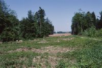
Title (German)
Halten, Heinrichswil SO, Waldschneise, Rodung im Herrenwald südwestlich von Hersiwil
Caption
Cleared forest aisle in Herrenwald southwest of Hersiwil, for new railway line SBB, partial view; Keywords Documenta Natura: track construction, landscape change, lowland, farmland, clearing, forest edge forest aisle.
Caption (German)
Gerodete Waldschneise im Herrenwald südwestlich von Hersiwil, für Neubahnstrecke SBB, Teilansicht; Schlagworte Documenta Natura: Gleisbau, Landschaftswandel, Flachland, Ackerland, Rodung, Waldrand Waldschneise
Record Name
Dia_303-34236

Title (German)
Halten, Heinrichswil SO, Waldschneise, Rodung im Herrenwald südwestlich von Hersiwil
Caption
Cleared forest aisle in Herrenwald southwest of Hersiwil, for new railway line SBB, general view; Keywords Documenta Natura: track construction, landscape change, lowland, farmland, clearing, forest edge forest aisle.
Caption (German)
Gerodete Waldschneise im Herrenwald südwestlich von Hersiwil, für Neubahnstrecke SBB, Gesamtansicht; Schlagworte Documenta Natura: Gleisbau, Landschaftswandel, Flachland, Ackerland, Rodung, Waldrand Waldschneise
Record Name
Dia_303-34238

Title (German)
Halten, Heinrichswil SO, Waldschneise, Rodung im Herrenwald südwestlich von Hersiwil
Caption
Cleared forest aisle in Herrenwald southwest of Hersiwil, for new railway line SBB, general view; Keywords Documenta Natura: track construction, landscape change, lowland, farmland, clearing, forest edge forest aisle.
Caption (German)
Gerodete Waldschneise im Herrenwald südwestlich von Hersiwil, für Neubahnstrecke SBB, Gesamtansicht; Schlagworte Documenta Natura: Gleisbau, Landschaftswandel, Flachland, Ackerland, Rodung, Waldrand Waldschneise
Record Name
Dia_303-34242
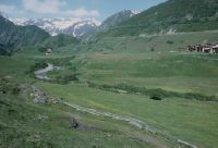
Title (German)
Tujetsch GR, Südostansicht von Selva mit den Weilern Sut Crestas, Clavau Sura und Weide Palius mit Vorderrhein, im Hintergrund Tschamut
Caption
Southeast view of the village of Selva with the hamlets of Sut Crestas and Clavau Sura, in the foreground pasture landscape Palius with the young Vorderrhein, in the background Tschamut, the Oberalp pass road and the railroad line of the Furka-Oberalp-Bahn (FO), first photograph (1995), partial view; coordinates (LV03) of the camera location: 698340/168313; keywords Documenta Natura: golf, mountain area, village, landscape change
Caption (German)
Südostansicht des Dorfes Selva mit den Weilern Sut Crestas und Clavau Sura, im Vordergrund Weidelandschaft Palius mit dem jungen Vorderrhein, im Hintergrund Tschamut, die Oberalppassstrasse und die Bahnlinie der Furka-Oberalp-Bahn (FO), Erstaufnahme (1995), Teilansicht; Koordinaten (LV03) des Kamerastandorts: 698340/168313; Schlagworte Documenta Natura: Golf, Berggebiet, Dorf, Landschaftswandel
Record Name
Dia_303-34245

Title (German)
Tujetsch GR, Südostansicht von Selva mit den Weilern Sut Crestas, Clavau Sura und Weide Palius mit Vorderrhein, im Hintergrund Tschamut
Caption
Southeast view of the village of Selva with the hamlets of Sut Crestas and Clavau Sura, in the foreground pasture landscape Palius with the young Vorderrhein, in the background Tschamut, the Oberalp pass road and the railroad line of the Furka-Oberalp-Bahn (FO), first photograph (1995), partial view; coordinates (LV03) of the camera location: 698340/168313; keywords Documenta Natura: golf, mountain area, village, landscape change
Caption (German)
Südostansicht des Dorfes Selva mit den Weilern Sut Crestas und Clavau Sura, im Vordergrund Weidelandschaft Palius mit dem jungen Vorderrhein, im Hintergrund Tschamut, die Oberalppassstrasse und die Bahnlinie der Furka-Oberalp-Bahn (FO), Erstaufnahme (1995), Teilansicht; Koordinaten (LV03) des Kamerastandorts: 698340/168313; Schlagworte Documenta Natura: Golf, Berggebiet, Dorf, Landschaftswandel
Record Name
Dia_303-34255

Title (German)
Tujetsch GR, Südostansicht von Selva mit den Weilern Sut Crestas, Clavau Sura und Weide Palius mit Vorderrhein, im Hintergrund Tschamut
Caption
Southeast view of the village of Selva with the hamlets of Sut Crestas and Clavau Sura, in the foreground pasture landscape Palius with the young Vorderrhein, in the background Tschamut, the Oberalp pass road and the railroad line of the Furka-Oberalp-Bahn (FO), 1st follow-up photograph during the construction of the golf course (1996), partial view; coordinates (LV03) of the camera location: 698340/168313; keywords Documenta Natura: golf, mountain area, village, landscape change
Caption (German)
Südostansicht des Dorfes Selva mit den Weilern Sut Crestas und Clavau Sura, im Vordergrund Weidelandschaft Palius mit dem jungen Vorderrhein, im Hintergrund Tschamut, die Oberalppassstrasse und die Bahnlinie der Furka-Oberalp-Bahn (FO), 1. Folgeaufnahme während dem Bau des Golfplatzes (1996), Teilansicht; Koordinaten (LV03) des Kamerastandorts: 698340/168313; Schlagworte Documenta Natura: Golf, Berggebiet, Dorf, Landschaftswandel
Record Name
Dia_303-34275

Title (German)
Tujetsch GR, Südostansicht von Selva mit den Weilern Sut Crestas, Clavau Sura und Weide Palius mit Vorderrhein, im Hintergrund Tschamut
Caption
Southeast view of the village of Selva with the hamlets of Sut Crestas and Clavau Sura, in the foreground pasture landscape Palius with the young Vorderrhein, in the background Tschamut, the Oberalp pass road and the railroad line of the Furka-Oberalp-Bahn (FO), 1st follow-up photograph during the construction of the golf course (1996), partial view; coordinates (LV03) of the camera location: 698340/168313; keywords Documenta Natura: golf, mountain area, village, landscape change
Caption (German)
Südostansicht des Dorfes Selva mit den Weilern Sut Crestas und Clavau Sura, im Vordergrund Weidelandschaft Palius mit dem jungen Vorderrhein, im Hintergrund Tschamut, die Oberalppassstrasse und die Bahnlinie der Furka-Oberalp-Bahn (FO), 1. Folgeaufnahme während dem Bau des Golfplatzes (1996), Teilansicht; Koordinaten (LV03) des Kamerastandorts: 698340/168313; Schlagworte Documenta Natura: Golf, Berggebiet, Dorf, Landschaftswandel
Record Name
Dia_303-34280

Title (German)
Tujetsch GR, Südostansicht von Selva mit den Weilern Sut Crestas, Clavau Sura und Weide Palius mit Vorderrhein, im Hintergrund Tschamut
Caption
Southeast view of the village of Selva with the hamlets of Sut Crestas and Clavau Sura, in the foreground pasture landscape Palius with the young Vorderrhein, in the background Tschamut, the Oberalp pass road and the railroad line of the Furka-Oberalp-Bahn (FO), 2nd follow-up photograph at the opening of the golf course (1997), partial view; coordinates (LV03) of the camera location: 698340/168313; keywords Documenta Natura: golf, mountain area, village, landscape change
Caption (German)
Südostansicht des Dorfes Selva mit den Weilern Sut Crestas und Clavau Sura, im Vordergrund Weidelandschaft Palius mit dem jungen Vorderrhein, im Hintergrund Tschamut, die Oberalppassstrasse und die Bahnlinie der Furka-Oberalp-Bahn (FO), 2. Folgeaufnahme bei der Eröffnung des Golfplatzes (1997), Teilansicht; Koordinaten (LV03) des Kamerastandorts: 698340/168313; Schlagworte Documenta Natura: Golf, Berggebiet, Dorf, Landschaftswandel
Record Name
Dia_303-34285

Title (German)
Tujetsch GR, Südostansicht von Selva mit den Weilern Sut Crestas, Clavau Sura und Weide Palius mit Vorderrhein, im Hintergrund Tschamut
Caption
Southeast view of the village of Selva with the hamlets of Sut Crestas and Clavau Sura, in the foreground pasture landscape Palius with the young Vorderrhein, in the background Tschamut, the Oberalp pass road and the railroad line of the Furka-Oberalp-Bahn (FO), 2nd follow-up photograph at the opening of the golf course (1997), partial view; coordinates (LV03) of the camera location: 698340/168313; keywords Documenta Natura: golf, mountain area, village, landscape change
Caption (German)
Südostansicht des Dorfes Selva mit den Weilern Sut Crestas und Clavau Sura, im Vordergrund Weidelandschaft Palius mit dem jungen Vorderrhein, im Hintergrund Tschamut, die Oberalppassstrasse und die Bahnlinie der Furka-Oberalp-Bahn (FO), 2. Folgeaufnahme bei der Eröffnung des Golfplatzes (1997), Teilansicht; Koordinaten (LV03) des Kamerastandorts: 698340/168313; Schlagworte Documenta Natura: Golf, Berggebiet, Dorf, Landschaftswandel
Record Name
Dia_303-34295

Title (German)
Tujetsch GR, Südostansicht der Weiler Surrein und Clavau Sura, im Hintergrund Selva
Caption
Pasture landscape with the hamlets of Surrein and Clavau Sura, in the background the village of Selva, the Oberalp pass road and the railroad line of the Furka-Oberalp-Bahn (FO), first photograph (1995), partial view; coordinates (LV03) of the camera location: 698710/168345; keywords Documenta Natura: golf, mountain area, village, landscape change
Caption (German)
Weidelandschaft mit den Weilern Surrein und Clavau Sura, im Hintergrund das Dorf Selva, die Oberalppassstrasse und die Bahnlinie der Furka-Oberalp-Bahn (FO), Erstaufnahme (1995), Teilansicht; Koordinaten (LV03) des Kamerastandorts: 698710/168345; Schlagworte Documenta Natura: Golf, Berggebiet, Dorf, Landschaftswandel
Record Name
Dia_303-34306

Title (German)
Tujetsch GR, Südostansicht der Weiler Surrein und Clavau Sura, im Hintergrund Selva
Caption
Pasture landscape with the hamlets of Surrein and Clavau Sura, in the background the village of Selva, the Oberalp pass road and the railroad line of the Furka-Oberalp-Bahn (FO), first photograph (1995), partial view; coordinates (LV03) of the camera location: 698710/168345; keywords Documenta Natura: golf, mountain area, village, landscape change
Caption (German)
Weidelandschaft mit den Weilern Surrein und Clavau Sura, im Hintergrund das Dorf Selva, die Oberalppassstrasse und die Bahnlinie der Furka-Oberalp-Bahn (FO), Erstaufnahme (1995), Teilansicht; Koordinaten (LV03) des Kamerastandorts: 698710/168345; Schlagworte Documenta Natura: Golf, Berggebiet, Dorf, Landschaftswandel
Record Name
Dia_303-34316

Title (German)
Tujetsch GR, Südostansicht der Weiler Surrein und Clavau Sura, im Hintergrund Selva
Caption
Pasture landscape with the hamlets of Surrein and Clavau Sura, in the background the village of Selva, the Oberalp pass road and the railroad line of the Furka-Oberalp-Bahn (FO), 1st follow-up photograph taken at the opening of the golf course (1997), partial view; coordinates (LV03) of the camera location: 698710/168345; keywords Documenta Natura: golf, mountain area, village, landscape change
Caption (German)
Weidelandschaft mit den Weilern Surrein und Clavau Sura, im Hintergrund das Dorf Selva, die Oberalppassstrasse und die Bahnlinie der Furka-Oberalp-Bahn (FO), 1. Folgeaufnahme bei der Eröffnung des Golfplatzes (1997), Teilansicht; Koordinaten (LV03) des Kamerastandorts: 698710/168345; Schlagworte Documenta Natura: Golf, Berggebiet, Dorf, Landschaftswandel
Record Name
Dia_303-34326

Title (German)
Tujetsch GR, Südostansicht der Weiler Surrein und Clavau Sura, im Hintergrund Selva
Caption
Pasture landscape with the hamlets of Surrein and Clavau Sura, in the background the village of Selva, the Oberalp pass road and the railroad line of the Furka-Oberalp-Bahn (FO), 1st follow-up photograph taken at the opening of the golf course (1997), partial view; coordinates (LV03) of the camera location: 698710/168345; keywords Documenta Natura: golf, mountain area, village, landscape change
Caption (German)
Weidelandschaft mit den Weilern Surrein und Clavau Sura, im Hintergrund das Dorf Selva, die Oberalppassstrasse und die Bahnlinie der Furka-Oberalp-Bahn (FO), 1. Folgeaufnahme bei der Eröffnung des Golfplatzes (1997), Teilansicht; Koordinaten (LV03) des Kamerastandorts: 698710/168345; Schlagworte Documenta Natura: Golf, Berggebiet, Dorf, Landschaftswandel
Record Name
Dia_303-34336

Title (German)
Tujetsch GR, Südwestansicht von Selva, im Vordergrund der Weiler Sut Crestas und Weide Palius mit Vorderrhein
Caption
Southwest view of the village of Selva, in the foreground the hamlet of Sut Crestas and pasture landscape Palius with the Vorderrhein, in the background the Oberalp pass road and the railroad line of the Furka-Oberalp-Bahn (FO), first photograph (1995), partial view; coordinates (LV03) of the camera location: 697725/167820; keywords Documenta Natura: golf, mountain area, village, landscape change
Caption (German)
Südwestansicht des Dorfes Selva, im Vordergrund der Weiler Sut Crestas und Weidelandschaft Palius mit dem Vorderrhein, im Hintergrund die Oberalppassstrasse und die Bahnlinie der Furka-Oberalp-Bahn (FO), Erstaufnahme (1995), Teilansicht; Koordinaten (LV03) des Kamerastandorts: 697725/167820; Schlagworte Documenta Natura: Golf, Berggebiet, Dorf, Landschaftswandel
Record Name
Dia_303-34347

Title (German)
Tujetsch GR, Südwestansicht von Selva, im Vordergrund der Weiler Sut Crestas und Weide Palius mit Vorderrhein
Caption
Southwest view of the village of Selva, in the foreground the hamlet of Sut Crestas and pasture landscape Palius with the Vorderrhein, in the background the Oberalp pass road and the railroad line of the Furka-Oberalp-Bahn (FO), 1st follow-up photograph during the construction of the golf course (1996), partial view; coordinates (LV03) of the camera location: 697725/167820; keywords Documenta Natura: golf, mountain area, village, landscape change
Caption (German)
Südwestansicht des Dorfes Selva, im Vordergrund der Weiler Sut Crestas und Weidelandschaft Palius mit dem Vorderrhein, im Hintergrund die Oberalppassstrasse und die Bahnlinie der Furka-Oberalp-Bahn (FO), 1. Folgeaufnahme während dem Bau des Golfplatzes (1996), Teilansicht; Koordinaten (LV03) des Kamerastandorts: 697725/167820; Schlagworte Documenta Natura: Golf, Berggebiet, Dorf, Landschaftswandel
Record Name
Dia_303-34357

Title (German)
Tujetsch GR, Südwestansicht von Selva, im Vordergrund der Weiler Sut Crestas und Weide Palius mit Vorderrhein
Caption
Southwest view of the village of Selva, in the foreground the hamlet of Sut Crestas and pasture landscape Palius with the Vorderrhein, in the background the Oberalp pass road and the railroad line of the Furka-Oberalp-Bahn (FO), 2nd follow-up photograph at the opening of the golf course (1997), partial view; coordinates (LV03) of the camera location: 697725/167820; keywords Documenta Natura: golf, mountain area, village, landscape change
Caption (German)
Südwestansicht des Dorfes Selva, im Vordergrund der Weiler Sut Crestas und Weidelandschaft Palius mit dem Vorderrhein, im Hintergrund die Oberalppassstrasse und die Bahnlinie der Furka-Oberalp-Bahn (FO), 2. Folgeaufnahme bei der Eröffnung des Golfplatzes (1997), Teilansicht; Koordinaten (LV03) des Kamerastandorts: 697725/167820; Schlagworte Documenta Natura: Golf, Berggebiet, Dorf, Landschaftswandel
Record Name
Dia_303-34367
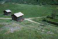
Title (German)
Tujetsch GR, Nordwestansicht des Weilers Sut Crestas (z. T.) bei Selva
Caption
Northwest view of the hamlet of Sut Crestas, with pasture and small pond for fish breeding, first photograph (1995), partial view; coordinates (LV03) of the camera location: 697595/167850; keywords Documenta Natura: golf, mountain area, village, landscape change
Caption (German)
Nordwestansicht des Weilers Sut Crestas, mit Weide und kleinem Teich für Fischzucht, Erstaufnahme (1995), Teilansicht; Koordinaten (LV03) des Kamerastandorts: 697595/167850; Schlagworte Documenta Natura: Golf, Berggebiet, Dorf, Landschaftswandel
Record Name
Dia_303-34378

Title (German)
Tujetsch GR, Nordwestansicht des Weilers Sut Crestas (z. T.) bei Selva
Caption
Northwest view of the hamlet of Sut Crestas, with pasture and small pond for fish breeding, 1st follow-up shot at the opening of the golf course (1997), partial view; coordinates (LV03) of the camera location: 697595/167850; keywords Documenta Natura: golf, mountain area, village, landscape change.
Caption (German)
Nordwestansicht des Weilers Sut Crestas, mit Weide und kleinem Teich für Fischzucht, 1. Folgeaufnahme bei der Eröffnung des Golfplatzes (1997), Teilansicht; Koordinaten (LV03) des Kamerastandorts: 697595/167850; Schlagworte Documenta Natura: Golf, Berggebiet, Dorf, Landschaftswandel
Record Name
Dia_303-34388

Title (German)
Tujetsch GR, Südwestansicht der Weide Palius mit Selva
Caption
Southwest view of the pasture landscape Palius with the village Selva, in the background the Oberalp pass road and the railroad line of the Furka-Oberalp-Bahn (FO), first photograph (1995), partial view; coordinates (LV03) of the camera location: 697838/168055; keywords Documenta Natura: golf, mountain area, village, landscape change
Caption (German)
Südwestansicht der Weidelandschaft Palius mit dem Dorf Selva, im Hintergrund die Oberalppassstrasse und die Bahnlinie der Furka-Oberalp-Bahn (FO), Erstaufnahme (1995), Teilansicht; Koordinaten (LV03) des Kamerastandorts: 697838/168055; Schlagworte Documenta Natura: Golf, Berggebiet, Dorf, Landschaftswandel
Record Name
Dia_303-34399

Title (German)
Tujetsch GR, Südwestansicht der Weide Palius mit Selva
Caption
Southwestern view of the pasture landscape Palius with the village Selva, in the background the Oberalp pass road and the railroad line of the Furka-Oberalp-Bahn (FO), 1st follow-up photo at the opening of the golf course (1997), partial view; coordinates (LV03) of the camera location: 697838/168055; keywords Documenta Natura: golf, mountain area, village, landscape change
Caption (German)
Südwestansicht der Weidelandschaft Palius mit dem Dorf Selva, im Hintergrund die Oberalppassstrasse und die Bahnlinie der Furka-Oberalp-Bahn (FO), 1. Folgeaufnahme bei der Eröffnung des Golfplatzes (1997), Teilansicht; Koordinaten (LV03) des Kamerastandorts: 697838/168055; Schlagworte Documenta Natura: Golf, Berggebiet, Dorf, Landschaftswandel
Record Name
Dia_303-34409

Title (German)
Tujetsch GR, Nordansicht des Weilers Sut Crestas westlich von Selva
Caption
North view of the hamlet of Sut Crestas, in the background the northwest slope with Crappa da Scharina and Val Scadialas, first photograph (1995), partial view; coordinates (LV03) of the camera location: 697728/168190; keywords Documenta Natura: golf, mountain area, village, landscape change
Caption (German)
Nordansicht des Weilers Sut Crestas, im Hintergrund der Nordwesthang mit Crappa da Scharina und Val Scadialas, Erstaufnahme (1995), Teilansicht; Koordinaten (LV03) des Kamerastandorts: 697728/168190; Schlagworte Documenta Natura: Golf, Berggebiet, Dorf, Landschaftswandel
Record Name
Dia_303-34420

Title (German)
Tujetsch GR, Nordansicht des Weilers Sut Crestas westlich von Selva
Caption
North view of the hamlet of Sut Crestas, in the background the northwest slope with Crappa da Scharina and Val Scadialas, 1st follow-up photograph during the construction of the golf course (1996), partial view; coordinates (LV03) of the camera location: 697728/168190; keywords Documenta Natura: golf, mountain area, village, landscape change
Caption (German)
Nordansicht des Weilers Sut Crestas, im Hintergrund der Nordwesthang mit Crappa da Scharina und Val Scadialas, 1. Folgeaufnahme während dem Bau des Golfplatzes (1996), Teilansicht; Koordinaten (LV03) des Kamerastandorts: 697728/168190; Schlagworte Documenta Natura: Golf, Berggebiet, Dorf, Landschaftswandel
Record Name
Dia_303-34430

Title (German)
Tujetsch GR, Nordansicht des Weilers Sut Crestas westlich von Selva
Caption
North view of the hamlet of Sut Crestas, in the background the northwest slope with Crappa da Scharina and Val Scadialas, 2nd follow-up photo taken at the opening of the golf course (1997), partial view; coordinates (LV03) of the camera location: 697728/168190; keywords Documenta Natura: golf, mountain area, village, landscape change
Caption (German)
Nordansicht des Weilers Sut Crestas, im Hintergrund der Nordwesthang mit Crappa da Scharina und Val Scadialas, 2. Folgeaufnahme bei der Eröffnung des Golfplatzes (1997), Teilansicht; Koordinaten (LV03) des Kamerastandorts: 697728/168190; Schlagworte Documenta Natura: Golf, Berggebiet, Dorf, Landschaftswandel
Record Name
Dia_303-34440

Title (German)
Luftraum zwischen Davos und Dübendorf
Caption
In the helicopter cockpit of an Alouette during the flight, in the foreground pilots and passenger, in the background mountain landscape , partial view; Keywords Documenta Natura: revitalization, conifer, mountain forest, loss of vitality
Caption (German)
Im Helikoptercockpit einer Alouette während dem Flug, im Vordergrund Piloten und Passagier, im Hintergrund Berglandschaft , Teilansicht; Schlagworte Documenta Natura: Revitalisierung, Nadelbaum, Gebirgswald, Vitalitaetsverlust
Record Name
Dia_303-34453

Title (German)
Luftraum zwischen Davos und Dübendorf
Caption
In the helicopter cockpit of an Alouette during flight, in the foreground pilot and passenger, view of mountain landscape with Lake Walen, partial view; Keywords Documenta Natura: revitalization, conifer, mountain forest, loss of vitality
Caption (German)
Im Helikoptercockpit einer Alouette während dem Flug, im Vordergrund Pilot und Passagier, Aussicht auf Berglandschaft mit Walensee, Teilansicht; Schlagworte Documenta Natura: Revitalisierung, Nadelbaum, Gebirgswald, Vitalitaetsverlust
Record Name
Dia_303-34454
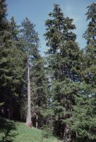
Title (German)
Alvaneu GR, Baumgruppe mit dem Baum 18 im Sektor F (Slow Release) und dem Erntebaum 5G im Sektor G (Kontrolle) in der Versuchsfläche beim Simmeliloch
Caption
Research work with spruce 18 in sector F (slow release) and harvest tree 5G in sector G (control) on the left side of the picture, with vitality difference, first photo taken in 1992, general view; Keywords Documenta Natura: revitalization, conifer, mountain forest, loss of vitality.
Caption (German)
Forschungsarbeit mit der Fichte 18 im Sektor F (Slow Release) und dem Erntebaum 5G im Sektor G (Kontrolle) links im Bild, mit Vitalitätsunterschied, Erstaufnahme 1992, Gesamtansicht; Schlagworte Documenta Natura: Revitalisierung, Nadelbaum, Gebirgswald, Vitalitaetsverlust
Record Name
Dia_303-34466

Title (German)
Alvaneu GR, Baumgruppe mit dem Baum 18 im Sektor F (Slow Release) und dem Erntebaum 5G im Sektor G (Kontrolle) in der Versuchsfläche beim Simmeliloch
Caption
Research work with spruce 18 in sector F (slow release) and harvest tree 5G in sector G (control) on the left side of the image, with vitality difference, first photo taken in 1992, partial view; Keywords Documenta Natura: revitalization, conifer, mountain forest, loss of vitality.
Caption (German)
Forschungsarbeit mit der Fichte 18 im Sektor F (Slow Release) und dem Erntebaum 5G im Sektor G (Kontrolle) links im Bild, mit Vitalitätsunterschied, Erstaufnahme 1992, Teilansicht; Schlagworte Documenta Natura: Revitalisierung, Nadelbaum, Gebirgswald, Vitalitaetsverlust
Record Name
Dia_303-34473

Title (German)
Alvaneu GR, Baumgruppe mit dem Baum 18 im Sektor F (Slow Release) und dem Erntebaum 5G im Sektor G (Kontrolle) in der Versuchsfläche beim Simmeliloch
Caption
Research work with spruce 18 in sector F (slow release) and harvest tree 5G in sector G (control) on the left of the image, with vitality difference, 1st follow-up image 1997, general view; Keywords Documenta Natura: revitalization, conifer, mountain forest, loss of vitality.
Caption (German)
Forschungsarbeit mit der Fichte 18 im Sektor F (Slow Release) und dem Erntebaum 5G im Sektor G (Kontrolle) links im Bild, mit Vitalitätsunterschied, 1. Folgeaufnahme 1997, Gesamtansicht; Schlagworte Documenta Natura: Revitalisierung, Nadelbaum, Gebirgswald, Vitalitaetsverlust
Record Name
Dia_303-34486

Title (German)
Alvaneu GR, Baumgruppe mit dem Baum 18 im Sektor F (Slow Release) und dem Erntebaum 5G im Sektor G (Kontrolle) in der Versuchsfläche beim Simmeliloch
Caption
Research work with spruce 18 in sector F (slow release) and harvest tree 5G in sector G (control) on the left of the image, with vitality difference, 1st follow-up photograph 1997, partial view; Keywords Documenta Natura: revitalization, conifer, mountain forest, loss of vitality.
Caption (German)
Forschungsarbeit mit der Fichte 18 im Sektor F (Slow Release) und dem Erntebaum 5G im Sektor G (Kontrolle) links im Bild, mit Vitalitätsunterschied, 1. Folgeaufnahme 1997, Teilansicht; Schlagworte Documenta Natura: Revitalisierung, Nadelbaum, Gebirgswald, Vitalitaetsverlust
Record Name
Dia_303-34496

Title (German)
Alvaneu GR, Baumgruppe mit den Bäumen 13 und 17 im Sektor B (Kontrolle) und dem Baum 28 im Sektor C (Slow Release) in der Versuchsfläche beim Simmeliloch
Caption
Research work with designated spruces 13 and 17 in sector B (control) and spruce 28 in sector C (slow release) on the right side of the image, with vitality difference, first photograph 1992, general view; keywords Documenta Natura: revitalization, conifer, mountain forest, loss of vitality.
Caption (German)
Forschungsarbeit mit den bezeichneten Fichten 13 und 17 im Sektor B (Kontrolle) und der Fichte 28 im Sektor C (Slow Release) rechts im Bild, mit Vitalitätsunterschied, Erstaufnahme 1992, Gesamtansicht; Schlagworte Documenta Natura: Revitalisierung, Nadelbaum, Gebirgswald, Vitalitaetsverlust
Record Name
Dia_303-34509

Title (German)
Alvaneu GR, Baumgruppe mit den Bäumen 13 und 17 im Sektor B (Kontrolle) und dem Baum 28 im Sektor C (Slow Release) in der Versuchsfläche beim Simmeliloch
Caption
Research work with designated spruces 13 and 17 in sector B (control) and spruce 28 in sector C (slow release) on the right side of the image, with vitality difference, first photograph 1992, partial view; keywords Documenta Natura: revitalization, conifer, mountain forest, loss of vitality.
Caption (German)
Forschungsarbeit mit den bezeichneten Fichten 13 und 17 im Sektor B (Kontrolle) und der Fichte 28 im Sektor C (Slow Release) rechts im Bild, mit Vitalitätsunterschied, Erstaufnahme 1992, Teilansicht; Schlagworte Documenta Natura: Revitalisierung, Nadelbaum, Gebirgswald, Vitalitaetsverlust
Record Name
Dia_303-34518

Title (German)
Alvaneu GR, Baumgruppe mit den Bäumen 13 und 17 im Sektor B (Kontrolle) und dem Baum 28 im Sektor C (Slow Release) in der Versuchsfläche beim Simmeliloch
Caption
Research work with designated spruces 13 and 17 in sector B (control) and spruce 28 in sector C (slow release) on the right side of the image, with vitality difference, 1st follow-up photograph 1997, general view; keywords Documenta Natura: revitalization, conifer, mountain forest, loss of vitality.
Caption (German)
Forschungsarbeit mit den bezeichneten Fichten 13 und 17 im Sektor B (Kontrolle) und der Fichte 28 im Sektor C (Slow Release) rechts im Bild, mit Vitalitätsunterschied, 1. Folgeaufnahme 1997, Gesamtansicht; Schlagworte Documenta Natura: Revitalisierung, Nadelbaum, Gebirgswald, Vitalitaetsverlust
Record Name
Dia_303-34528

Title (German)
Alvaneu GR, Baumgruppe mit den Bäumen 13 und 17 im Sektor B (Kontrolle) und dem Baum 28 im Sektor C (Slow Release) in der Versuchsfläche beim Simmeliloch
Caption
Research work with designated spruces 13 and 17 in sector B (control) and spruce 28 in sector C (slow release) on the right side of the image, with vitality difference, 1st follow-up photograph 1997, partial view; keywords Documenta Natura: revitalization, conifer, mountain forest, loss of vitality.
Caption (German)
Forschungsarbeit mit den bezeichneten Fichten 13 und 17 im Sektor B (Kontrolle) und der Fichte 28 im Sektor C (Slow Release) rechts im Bild, mit Vitalitätsunterschied, 1. Folgeaufnahme 1997, Teilansicht; Schlagworte Documenta Natura: Revitalisierung, Nadelbaum, Gebirgswald, Vitalitaetsverlust
Record Name
Dia_303-34538

Title (German)
Alvaneu GR, Baumgruppe mit den Bäumen 5B und C-Nachbar auf der Trennlinie zwischen Sektor B (Kontrolle) und C (Slow Release) in der Versuchsfläche beim Simmeliloch
Caption
Research work with spruce 5B and C-neighbor with vitality difference on the dividing line between sector B (control) and C (slow release) on the left side of the picture, first photograph 1992, general view; Keywords Documenta Natura: revitalization, conifer, mountain forest, loss of vitality.
Caption (German)
Forschungsarbeit mit den Fichten 5B und C-Nachbar mit Vitalitätsunterschied auf der Trennlinie zwischen Sektor B (Kontrolle) und C (Slow Release) links im Bild, Erstaufnahme 1992, Gesamtansicht; Schlagworte Documenta Natura: Revitalisierung, Nadelbaum, Gebirgswald, Vitalitaetsverlust
Record Name
Dia_303-34548

Title (German)
Alvaneu GR, Baumgruppe mit den Bäumen 5B und C-Nachbar auf der Trennlinie zwischen Sektor B (Kontrolle) und C (Slow Release) in der Versuchsfläche beim Simmeliloch
Caption
Research work with spruces 5B and C-neighbor with vitality difference on the dividing line between sector B (control) and C (slow release) on the left side of the picture, first photo taken in 1992, partial view of the tree crowns; keywords Documenta Natura: revitalization, conifer, mountain forest, loss of vitality.
Caption (German)
Forschungsarbeit mit den Fichten 5B und C-Nachbar mit Vitalitätsunterschied auf der Trennlinie zwischen Sektor B (Kontrolle) und C (Slow Release) links im Bild, Erstaufnahme 1992, Teilansicht der Baumkronen; Schlagworte Documenta Natura: Revitalisierung, Nadelbaum, Gebirgswald, Vitalitaetsverlust
Record Name
Dia_303-34557

Title (German)
Alvaneu GR, Baumgruppe mit den Bäumen 5B und C-Nachbar auf der Trennlinie zwischen Sektor B (Kontrolle) und C (Slow Release) in der Versuchsfläche beim Simmeliloch
Caption
Research work with spruce 5B and C-neighbor with vitality difference on the dividing line between sector B (control) and C (slow release) on the left side of the picture, first photo taken in 1992, detail view of branches; keywords Documenta Natura: revitalization, conifer, mountain forest, loss of vitality.
Caption (German)
Forschungsarbeit mit den Fichten 5B und C-Nachbar mit Vitalitätsunterschied auf der Trennlinie zwischen Sektor B (Kontrolle) und C (Slow Release) links im Bild, Erstaufnahme 1992, Detailansicht der Äste; Schlagworte Documenta Natura: Revitalisierung, Nadelbaum, Gebirgswald, Vitalitaetsverlust
Record Name
Dia_303-34568

Title (German)
Alvaneu GR, Baumgruppe mit den Bäumen 5B und C-Nachbar auf der Trennlinie zwischen Sektor B (Kontrolle) und C (Slow Release) in der Versuchsfläche beim Simmeliloch
Caption
Research work with spruce 5B and C-neighbor with vitality difference on the dividing line between sector B (control) and C (slow release) on the left side of the picture, first photo taken in 1992, detail view of branches; keywords Documenta Natura: revitalization, conifer, mountain forest, loss of vitality.
Caption (German)
Forschungsarbeit mit den Fichten 5B und C-Nachbar mit Vitalitätsunterschied auf der Trennlinie zwischen Sektor B (Kontrolle) und C (Slow Release) links im Bild, Erstaufnahme 1992, Detailansicht der Äste; Schlagworte Documenta Natura: Revitalisierung, Nadelbaum, Gebirgswald, Vitalitaetsverlust
Record Name
Dia_303-34579

Title (German)
Alvaneu GR, Baumgruppe mit den Bäumen 5B und C-Nachbar auf der Trennlinie zwischen Sektor B (Kontrolle) und C (Slow Release) in der Versuchsfläche beim Simmeliloch
Caption
Research work with spruce 5B and C-neighbor with vitality difference on the dividing line between sector B (control) and C (slow release) on the left side of the picture, first photo taken in 1992, detail view of branches; keywords Documenta Natura: revitalization, conifer, mountain forest, loss of vitality.
Caption (German)
Forschungsarbeit mit den Fichten 5B und C-Nachbar mit Vitalitätsunterschied auf der Trennlinie zwischen Sektor B (Kontrolle) und C (Slow Release) links im Bild, Erstaufnahme 1992, Detailansicht der Äste; Schlagworte Documenta Natura: Revitalisierung, Nadelbaum, Gebirgswald, Vitalitaetsverlust
Record Name
Dia_303-34584

Title (German)
Alvaneu GR, Baumgruppe mit den Bäumen 5B und C-Nachbar auf der Trennlinie zwischen Sektor B (Kontrolle) und C (Slow Release) in der Versuchsfläche beim Simmeliloch
Caption
Research work with spruces 5B and C-neighbor with vitality difference on the dividing line between sector B (control) and C (slow release) on the left side of the picture, 1st follow-up photograph 1997, partial view of the tree crowns; keywords Documenta Natura: revitalization, conifer, mountain forest, loss of vitality.
Caption (German)
Forschungsarbeit mit den Fichten 5B und C-Nachbar mit Vitalitätsunterschied auf der Trennlinie zwischen Sektor B (Kontrolle) und C (Slow Release) links im Bild, 1. Folgeaufnahme 1997, Teilansicht der Baumkronen; Schlagworte Documenta Natura: Revitalisierung, Nadelbaum, Gebirgswald, Vitalitaetsverlust
Record Name
Dia_303-34592

Title (German)
Alvaneu GR, Baumgruppe mit den Bäumen 5B und C-Nachbar auf der Trennlinie zwischen Sektor B (Kontrolle) und C (Slow Release) in der Versuchsfläche beim Simmeliloch
Caption
Research work with spruce 5B and C-neighbor with vitality difference on the dividing line between sector B (control) and C (slow release) on the left side of the image, 1st follow-up image 1997, detail view of branches; keywords Documenta Natura: revitalization, conifer, mountain forest, loss of vitality.
Caption (German)
Forschungsarbeit mit den Fichten 5B und C-Nachbar mit Vitalitätsunterschied auf der Trennlinie zwischen Sektor B (Kontrolle) und C (Slow Release) links im Bild, 1. Folgeaufnahme 1997, Detailansicht der Äste; Schlagworte Documenta Natura: Revitalisierung, Nadelbaum, Gebirgswald, Vitalitaetsverlust
Record Name
Dia_303-34604

Title (German)
Alvaneu GR, Baumgruppe mit den Bäumen 5B und C-Nachbar auf der Trennlinie zwischen Sektor B (Kontrolle) und C (Slow Release) in der Versuchsfläche beim Simmeliloch
Caption
Research work with spruce 5B and C-neighbor with vitality difference on the dividing line between sector B (control) and C (slow release) on the left side of the image, 1st follow-up image 1997, detail view of branches; keywords Documenta Natura: revitalization, conifer, mountain forest, loss of vitality.
Caption (German)
Forschungsarbeit mit den Fichten 5B und C-Nachbar mit Vitalitätsunterschied auf der Trennlinie zwischen Sektor B (Kontrolle) und C (Slow Release) links im Bild, 1. Folgeaufnahme 1997, Detailansicht der Äste; Schlagworte Documenta Natura: Revitalisierung, Nadelbaum, Gebirgswald, Vitalitaetsverlust
Record Name
Dia_303-34614

Title (German)
Alvaneu GR, Baumgruppe auf der Trennlinie zwischen Sektor C und D in der Versuchsfläche beim Simmeliloch
Caption
Research work with spruce trees, with vitality difference on the dividing line between sector C (slow release) and D (control) on the left of the image, first photo taken in 1992, general view; keywords Documenta Natura: revitalization, conifer, mountain forest, loss of vitality.
Caption (German)
Forschungsarbeit mit Fichten, mit Vitalitätsunterschied auf der Trennlinie zwischen Sektor C (Slow Release) und D (Kontrolle) links im Bild, Erstaufnahme 1992, Gesamtansicht; Schlagworte Documenta Natura: Revitalisierung, Nadelbaum, Gebirgswald, Vitalitaetsverlust
Record Name
Dia_303-34623

Title (German)
Alvaneu GR, Baumgruppe auf der Trennlinie zwischen Sektor C und D in der Versuchsfläche beim Simmeliloch
Caption
Research work with spruce trees, with vitality difference on the dividing line between sector C (slow release) and D (control) on the left of the image, first image taken in 1992, partial view of tree crowns; keywords Documenta Natura: revitalization, conifer, mountain forest, loss of vitality.
Caption (German)
Forschungsarbeit mit Fichten, mit Vitalitätsunterschied auf der Trennlinie zwischen Sektor C (Slow Release) und D (Kontrolle) links im Bild, Erstaufnahme 1992, Teilansicht der Baumkronen; Schlagworte Documenta Natura: Revitalisierung, Nadelbaum, Gebirgswald, Vitalitaetsverlust
Record Name
Dia_303-34638

Title (German)
Alvaneu GR, Baumgruppe auf der Trennlinie zwischen Sektor C und D in der Versuchsfläche beim Simmeliloch
Caption
Research work with spruce, with vitality difference on the dividing line between sector C (slow release) and D (control) on the left of the image, 1st follow-up image 1997, general view; Keywords Documenta Natura: revitalization, conifer, mountain forest, loss of vitality.
Caption (German)
Forschungsarbeit mit Fichten, mit Vitalitätsunterschied auf der Trennlinie zwischen Sektor C (Slow Release) und D (Kontrolle) links im Bild, 1. Folgeaufnahme 1997, Gesamtansicht; Schlagworte Documenta Natura: Revitalisierung, Nadelbaum, Gebirgswald, Vitalitaetsverlust
Record Name
Dia_303-34648

Title (German)
Alvaneu GR, Baumgruppe auf der Trennlinie zwischen Sektor C und D in der Versuchsfläche beim Simmeliloch
Caption
Research work with spruce, with vitality difference on the dividing line between sector C (slow release) and D (control) on the left of the image, 1st follow-up image 1997, general view; Keywords Documenta Natura: revitalization, conifer, mountain forest, loss of vitality.
Caption (German)
Forschungsarbeit mit Fichten, mit Vitalitätsunterschied auf der Trennlinie zwischen Sektor C (Slow Release) und D (Kontrolle) links im Bild, 1. Folgeaufnahme 1997, Gesamtansicht; Schlagworte Documenta Natura: Revitalisierung, Nadelbaum, Gebirgswald, Vitalitaetsverlust
Record Name
Dia_303-34653

Title (German)
Alvaneu GR, Baumgruppe auf der Trennlinie zwischen Sektor C und D in der Versuchsfläche beim Simmeliloch
Caption
Research work with spruce trees, with vitality difference on the dividing line between sector C (slow release) and D (control) on the left of the image, 1st follow-up image 1997, partial view of tree crowns; keywords Documenta Natura: revitalization, conifer, mountain forest, loss of vitality.
Caption (German)
Forschungsarbeit mit Fichten, mit Vitalitätsunterschied auf der Trennlinie zwischen Sektor C (Slow Release) und D (Kontrolle) links im Bild, 1. Folgeaufnahme 1997, Teilansicht der Baumkronen; Schlagworte Documenta Natura: Revitalisierung, Nadelbaum, Gebirgswald, Vitalitaetsverlust
Record Name
Dia_303-34658

Title (German)
Alvaneu GR, In der Versuchsfläche beim Simmeliloch
Caption
Research work in protection forest to study vitality differences in spruce trees in mountain forest, general view; Keywords Documenta Natura: revitalization, conifer, mountain forest, vitality loss.
Caption (German)
Forschungsarbeit in Schutzwald zur Untersuchung von Vitalitätsunterschieden an Fichten im Gebirgswald, Gesamtansicht; Schlagworte Documenta Natura: Revitalisierung, Nadelbaum, Gebirgswald, Vitalitaetsverlust
Record Name
Dia_303-34664

Title (German)
Alvaneu GR, In der Versuchsfläche beim Simmeliloch
Caption
Research work in protection forest to study vitality differences in spruce trees in mountain forest, general view; Keywords Documenta Natura: revitalization, conifer, mountain forest, vitality loss.
Caption (German)
Forschungsarbeit in Schutzwald zur Untersuchung von Vitalitätsunterschieden an Fichten im Gebirgswald, Gesamtansicht; Schlagworte Documenta Natura: Revitalisierung, Nadelbaum, Gebirgswald, Vitalitaetsverlust
Record Name
Dia_303-34669

Title (German)
Alvaneu GR, In der Versuchsfläche beim Simmeliloch
Caption
Research work in protection forest to study vitality differences in spruce trees in mountain forest, partial view; Keywords Documenta Natura: revitalization, conifer, mountain forest, vitality loss.
Caption (German)
Forschungsarbeit in Schutzwald zur Untersuchung von Vitalitätsunterschieden an Fichten im Gebirgswald, Teilansicht; Schlagworte Documenta Natura: Revitalisierung, Nadelbaum, Gebirgswald, Vitalitaetsverlust
Record Name
Dia_303-34674
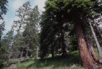
Title (German)
Alvaneu GR, In der Versuchsfläche beim Simmeliloch
Caption
Research work in protection forest to study vitality differences in spruce trees in mountain forest, partial view; Keywords Documenta Natura: revitalization, conifer, mountain forest, vitality loss.
Caption (German)
Forschungsarbeit in Schutzwald zur Untersuchung von Vitalitätsunterschieden an Fichten im Gebirgswald, Teilansicht; Schlagworte Documenta Natura: Revitalisierung, Nadelbaum, Gebirgswald, Vitalitaetsverlust
Record Name
Dia_303-34677

Title (German)
Alvaneu GR, In der Versuchsfläche beim Simmeliloch
Caption
Research work in protection forest to study vitality differences in spruce trees in mountain forest, general view; Keywords Documenta Natura: revitalization, conifer, mountain forest, vitality loss.
Caption (German)
Forschungsarbeit in Schutzwald zur Untersuchung von Vitalitätsunterschieden an Fichten im Gebirgswald, Gesamtansicht; Schlagworte Documenta Natura: Revitalisierung, Nadelbaum, Gebirgswald, Vitalitaetsverlust
Record Name
Dia_303-34681

Title (German)
Alvaneu GR, In der Versuchsfläche beim Simmeliloch
Caption
Research work in protection forest to study vitality differences in spruce trees in mountain forest, general view; Keywords Documenta Natura: revitalization, conifer, mountain forest, vitality loss.
Caption (German)
Forschungsarbeit in Schutzwald zur Untersuchung von Vitalitätsunterschieden an Fichten im Gebirgswald, Gesamtansicht; Schlagworte Documenta Natura: Revitalisierung, Nadelbaum, Gebirgswald, Vitalitaetsverlust
Record Name
Dia_303-34684

Title (German)
Alvaneu GR, In der Versuchsfläche beim Simmeliloch
Caption
Research work in protection forest to study vitality differences in spruce trees in mountain forest, general view; Keywords Documenta Natura: revitalization, conifer, mountain forest, vitality loss.
Caption (German)
Forschungsarbeit in Schutzwald zur Untersuchung von Vitalitätsunterschieden an Fichten im Gebirgswald, Gesamtansicht; Schlagworte Documenta Natura: Revitalisierung, Nadelbaum, Gebirgswald, Vitalitaetsverlust
Record Name
Dia_303-34690

Title (German)
Alvaneu GR, In der Versuchsfläche beim Simmeliloch
Caption
Walter Flückiger and his colleagues taking root samples and soil samples with spades for research work, in the test plot in the protection forest; keywords Documenta Natura: revitalization, conifer, mountain forest, loss of vitality
Caption (German)
Walter Flückiger und seine MitarbeiterInnen beim Entnehmen von Wurzelproben und Bodenproben mit Spaten für Forschungsarbeit, in der Versuchsfläche im Schutzwald; Schlagworte Documenta Natura: Revitalisierung, Nadelbaum, Gebirgswald, Vitalitaetsverlust
Record Name
Dia_303-34697

Title (German)
Alvaneu GR, In der Versuchsfläche beim Simmeliloch
Caption
Soil sample on spade, detail view; Keywords Documenta Natura: revitalization, conifer, mountain forest, loss of vitality.
Caption (German)
Bodenprobe auf Spaten, Detailansicht; Schlagworte Documenta Natura: Revitalisierung, Nadelbaum, Gebirgswald, Vitalitaetsverlust
Record Name
Dia_303-34701

Title (German)
Alvaneu GR, In der Versuchsfläche beim Simmeliloch
Caption
Correct poking with spade for taking a soil and root sample; Keywords Documenta Natura: revitalization, conifer, mountain forest, loss of vitality.
Caption (German)
Korrektes Stechen mit Spaten für die Entnahme einer Boden- und Wurzelprobe; Schlagworte Documenta Natura: Revitalisierung, Nadelbaum, Gebirgswald, Vitalitaetsverlust
Record Name
Dia_303-34707

Title (German)
Alvaneu GR, In der Versuchsfläche beim Simmeliloch
Caption
Forest warden taking a soil and root sample and putting it into a storage bag; keywords Documenta Natura: revitalization, conifer, mountain forest, loss of vitality.
Caption (German)
Forstwart beim Entnehmen einer Boden- und Wurzelprobe und Einfüllen in einen Aufbewahrungssack; Schlagworte Documenta Natura: Revitalisierung, Nadelbaum, Gebirgswald, Vitalitaetsverlust
Record Name
Dia_303-34708

Title (German)
Alvaneu GR, In der Versuchsfläche beim Simmeliloch
Caption
Walter Flückiger and his collaborator taking notes in the forest for research work, in the experimental area in the protection forest ; keywords Documenta Natura: revitalization, conifer, mountain forest, loss of vitality
Caption (German)
Walter Flückiger und seine Mitarbeiterin beim Notieren im Wald für Forschungsarbeit, in der Versuchsfläche im Schutzwald ; Schlagworte Documenta Natura: Revitalisierung, Nadelbaum, Gebirgswald, Vitalitaetsverlust
Record Name
Dia_303-34711

Title (German)
Alvaneu GR, In der Versuchsfläche beim Simmeliloch
Caption
Tree marked for soil and root sampling, with storage bag and pick; keywords Documenta Natura: revitalization, conifer, mountain forest, loss of vitality.
Caption (German)
Für die Boden- und Wurzelprobe markierter Baum, mit Aufbewahrungssack und Pickel; Schlagworte Documenta Natura: Revitalisierung, Nadelbaum, Gebirgswald, Vitalitaetsverlust
Record Name
Dia_303-34714

Title (German)
Alvaneu GR, In der Versuchsfläche beim Simmeliloch
Caption
Forest warden taking a soil and root sample and putting it into a storage bag; keywords Documenta Natura: revitalization, conifer, mountain forest, loss of vitality.
Caption (German)
Forstwart beim Entnehmen einer Boden- und Wurzelprobe und Einfüllen in einen Aufbewahrungssack; Schlagworte Documenta Natura: Revitalisierung, Nadelbaum, Gebirgswald, Vitalitaetsverlust
Record Name
Dia_303-34722

Title (German)
Alvaneu GR, In der Versuchsfläche beim Simmeliloch
Caption
Forest warden stabbing a soil and root sample with spade; keywords Documenta Natura: revitalization, conifer, mountain forest, loss of vitality.
Caption (German)
Forstwart beim Stechen einer Boden- und Wurzelprobe mit Spaten; Schlagworte Documenta Natura: Revitalisierung, Nadelbaum, Gebirgswald, Vitalitaetsverlust
Record Name
Dia_303-34725

Title (German)
Alvaneu GR, In der Versuchsfläche beim Simmeliloch
Caption
Poked hole for taking a root and soil sample; Keywords Documenta Natura: revitalization, conifer, mountain forest, loss of vitality.
Caption (German)
Ausgestochenes Loch für die Entnahme einer Wurzel- und Bodenprobe; Schlagworte Documenta Natura: Revitalisierung, Nadelbaum, Gebirgswald, Vitalitaetsverlust
Record Name
Dia_303-34729

Title (German)
Alvaneu GR, In der Versuchsfläche beim Simmeliloch
Caption
Poked hole for taking a root and soil sample; Keywords Documenta Natura: revitalization, conifer, mountain forest, loss of vitality.
Caption (German)
Ausgestochenes Loch für die Entnahme einer Wurzel- und Bodenprobe; Schlagworte Documenta Natura: Revitalisierung, Nadelbaum, Gebirgswald, Vitalitaetsverlust
Record Name
Dia_303-34731
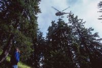
Title (German)
Alvaneu GR, In der Versuchsfläche beim Simmeliloch
Caption
Flight helper directing the helicopter to the harvest tree; Keywords Documenta Natura: revitalization, conifer, mountain forest, loss of vitality.
Caption (German)
Flughelfer beim Einweisen des Helikopters an den Erntebaum; Schlagworte Documenta Natura: Revitalisierung, Nadelbaum, Gebirgswald, Vitalitaetsverlust
Record Name
Dia_303-34733

Title (German)
Alvaneu GR, In der Versuchsfläche beim Simmeliloch
Caption
Flight helper directing the helicopter to the harvest tree; Keywords Documenta Natura: revitalization, conifer, mountain forest, loss of vitality.
Caption (German)
Flughelfer beim Einweisen des Helikopters an den Erntebaum; Schlagworte Documenta Natura: Revitalisierung, Nadelbaum, Gebirgswald, Vitalitaetsverlust
Record Name
Dia_303-34739

Title (German)
Alvaneu GR, In der Versuchsfläche beim Simmeliloch
Caption
Helicopter over harvesting tree with forester roped to winch; keywords Documenta Natura: revitalization, conifer, mountain forest, loss of vitality.
Caption (German)
Helikopter über dem Erntebaum mit angeseiltem Forstwart an der Seilwinde; Schlagworte Documenta Natura: Revitalisierung, Nadelbaum, Gebirgswald, Vitalitaetsverlust
Record Name
Dia_303-34742

Title (German)
Alvaneu GR, In der Versuchsfläche beim Simmeliloch
Caption
Helicopter over harvesting tree with forester roped to winch; keywords Documenta Natura: revitalization, conifer, mountain forest, loss of vitality.
Caption (German)
Helikopter über dem Erntebaum mit angeseiltem Forstwart an der Seilwinde; Schlagworte Documenta Natura: Revitalisierung, Nadelbaum, Gebirgswald, Vitalitaetsverlust
Record Name
Dia_303-34751
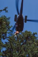
Title (German)
Alvaneu GR, In der Versuchsfläche beim Simmeliloch
Caption
Forest warden attached to helicopter winch harvesting spruce branches; keywords Documenta Natura: revitalization, conifer, mountain forest, loss of vitality
Caption (German)
An Seilwinde des Helikopters angeseilter Forstwart beim Ernten der Fichtenzweige; Schlagworte Documenta Natura: Revitalisierung, Nadelbaum, Gebirgswald, Vitalitaetsverlust
Record Name
Dia_303-34785

Title (German)
Alvaneu GR, In der Versuchsfläche beim Simmeliloch
Caption
Forest warden attached to helicopter winch harvesting spruce branches; keywords Documenta Natura: revitalization, conifer, mountain forest, loss of vitality
Caption (German)
An Seilwinde des Helikopters angeseilter Forstwart beim Ernten der Fichtenzweige; Schlagworte Documenta Natura: Revitalisierung, Nadelbaum, Gebirgswald, Vitalitaetsverlust
Record Name
Dia_303-34791
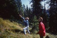
Title (German)
Alvaneu GR, In der Versuchsfläche beim Simmeliloch
Caption
Flight assistants radioing the helicopter to the harvest tree; Keywords Documenta Natura: revitalization, conifer, mountain forest, loss of vitality.
Caption (German)
Flughelfer beim Einweisen des Helikopters per Funk an den Erntebaum; Schlagworte Documenta Natura: Revitalisierung, Nadelbaum, Gebirgswald, Vitalitaetsverlust
Record Name
Dia_303-34807

Title (German)
Alvaneu GR, In der Versuchsfläche beim Simmeliloch
Caption
Forest warden at a marked harvest tree (spruce); keywords Documenta Natura: revitalization, conifer, mountain forest, loss of vitality.
Caption (German)
Forstwart bei einem markierten Erntebaum (Fichte); Schlagworte Documenta Natura: Revitalisierung, Nadelbaum, Gebirgswald, Vitalitaetsverlust
Record Name
Dia_303-34826

Title (German)
Alvaneu GR, In der Versuchsfläche beim Simmeliloch
Caption
Storage bags with the collected and harvested spruce branches; keywords Documenta Natura: revitalization, conifer, mountain forest, loss of vitality.
Caption (German)
Aufbewahrungssäcke mit den eingesammelten und geernteten Fichtenzweigen; Schlagworte Documenta Natura: Revitalisierung, Nadelbaum, Gebirgswald, Vitalitaetsverlust
Record Name
Dia_303-34839

Title (German)
Alvaneu GR, Schmitten GR, Südostansicht der Versuchsfläche im Simmeliloch oberhalb Voltära, z. T. mit Solas Davains, Schmittner Bach, Zalaint, Val Tearm und Schmitten (z. T.)
Caption
Southeast view of the experimental area in Simmeliloch with Solas Davains, Valtära, Schmittner Bach, Zalaint, Val Tearm and Schmitten, counter-slope view, general view; coordinates (LV03) of camera location: 771900/170520; keywords Documenta Natura: revitalization, conifer, mountain forest, loss of vitality.
Caption (German)
Südostansicht der Versuchsfläche im Simmeliloch mit Solas Davains, Valtära, Schmittner Bach, Zalaint, Val Tearm und Schmitten, Gegenhangaufnahme, Gesamtansicht; Koordinaten (LV03) des Kamerastandorts: 771900/170520; Schlagworte Documenta Natura: Revitalisierung, Nadelbaum, Gebirgswald, Vitalitaetsverlust
Record Name
Dia_303-34842

Title (German)
Alvaneu GR, Schmitten GR, Südostansicht der Versuchsfläche im Simmeliloch oberhalb Voltära, z. T. mit Solas Davains, Schmittner Bach, Zalaint, Val Tearm und Schmitten (z. T.)
Caption
Southeast view of the experimental area in the Simmeliloch with Valtära, counter-slope image, partial view; coordinates (LV03) of the camera location: 771900/170520; keywords Documenta Natura: revitalization, conifer, mountain forest, loss of vitality.
Caption (German)
Südostansicht der Versuchsfläche im Simmeliloch mit Valtära, Gegenhangaufnahme, Teilansicht; Koordinaten (LV03) des Kamerastandorts: 771900/170520; Schlagworte Documenta Natura: Revitalisierung, Nadelbaum, Gebirgswald, Vitalitaetsverlust
Record Name
Dia_303-34848
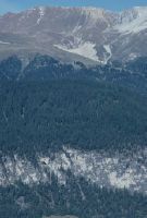
Title (German)
Alvaneu GR, Schmitten GR, Südostansicht der Versuchsfläche im Simmeliloch oberhalb Voltära, z. T. mit Solas Davains, Schmittner Bach, Zalaint, Val Tearm und Schmitten (z. T.)
Caption
Southeast view of the experimental plot in Simmeliloch, counter-slope image, partial view; coordinates (LV03) of camera location: 771450/170620; keywords Documenta Natura: revitalization, conifer, mountain forest, loss of vitality.
Caption (German)
Südostansicht der Versuchsfläche im Simmeliloch, Gegenhangaufnahme, Teilansicht; Koordinaten (LV03) des Kamerastandorts: 771450/170620; Schlagworte Documenta Natura: Revitalisierung, Nadelbaum, Gebirgswald, Vitalitaetsverlust
Record Name
Dia_303-34850

Title (German)
Alvaneu GR, In der Versuchsfläche beim Simmeliloch
Caption
Various forestry and meteorological measuring equipment and measuring devices in experimental forestry, general view; keywords Documenta Natura: revitalization, coniferous tree, mountain forest, loss of vitality
Caption (German)
Diverse forstliche und meteorologische Messeinrichtungen und Messgeräte in Versuchswaldung, Gesamtansicht; Schlagworte Documenta Natura: Revitalisierung, Nadelbaum, Gebirgswald, Vitalitaetsverlust
Record Name
Dia_303-34854

Title (German)
Alvaneu GR, In der Versuchsfläche beim Simmeliloch
Caption
Various forestry and meteorological measuring equipment and measuring devices in experimental forestry, general view; keywords Documenta Natura: revitalization, coniferous tree, mountain forest, loss of vitality
Caption (German)
Diverse forstliche und meteorologische Messeinrichtungen und Messgeräte in Versuchswaldung, Gesamtansicht; Schlagworte Documenta Natura: Revitalisierung, Nadelbaum, Gebirgswald, Vitalitaetsverlust
Record Name
Dia_303-34857

Title (German)
Alvaneu GR, In der Versuchsfläche beim Simmeliloch
Caption
Various forestry and meteorological measuring equipment and measuring devices in experimental forestry, general view; keywords Documenta Natura: revitalization, coniferous tree, mountain forest, loss of vitality
Caption (German)
Diverse forstliche und meteorologische Messeinrichtungen und Messgeräte in Versuchswaldung, Gesamtansicht; Schlagworte Documenta Natura: Revitalisierung, Nadelbaum, Gebirgswald, Vitalitaetsverlust
Record Name
Dia_303-34860

Title (German)
Alvaneu GR, In der Versuchsfläche beim Simmeliloch
Caption
Various forestry and meteorological measuring equipment and measuring devices in experimental forestry, general view; keywords Documenta Natura: revitalization, coniferous tree, mountain forest, loss of vitality
Caption (German)
Diverse forstliche und meteorologische Messeinrichtungen und Messgeräte in Versuchswaldung, Gesamtansicht; Schlagworte Documenta Natura: Revitalisierung, Nadelbaum, Gebirgswald, Vitalitaetsverlust
Record Name
Dia_303-34865

Title (German)
Alvaneu GR, In der Versuchsfläche beim Simmeliloch
Caption
Various forestry and meteorological measuring equipment and measuring devices in experimental forestry, general view; keywords Documenta Natura: revitalization, coniferous tree, mountain forest, loss of vitality
Caption (German)
Diverse forstliche und meteorologische Messeinrichtungen und Messgeräte in Versuchswaldung, Gesamtansicht; Schlagworte Documenta Natura: Revitalisierung, Nadelbaum, Gebirgswald, Vitalitaetsverlust
Record Name
Dia_303-34868

Title (German)
Alvaneu GR, In der Versuchsfläche beim Simmeliloch
Caption
Various forestry and meteorological measuring equipment and measuring devices in experimental forestry, general view; keywords Documenta Natura: revitalization, coniferous tree, mountain forest, loss of vitality
Caption (German)
Diverse forstliche und meteorologische Messeinrichtungen und Messgeräte in Versuchswaldung, Gesamtansicht; Schlagworte Documenta Natura: Revitalisierung, Nadelbaum, Gebirgswald, Vitalitaetsverlust
Record Name
Dia_303-34871

Title (German)
Les Bois JU, Kulturlandschaft zwischen den Weilern La Broche und Les Murs
Caption
Intensively used Freiberg cultural landscape (arable land and meadowland) with road and forest edge, first photograph (1993), partial view; coordinates (LV03) of camera location: 559165/224650; keywords Documenta Natura: Golf, Jura, landscape change.
Caption (German)
Intensiv genutzte Freiberger Kulturlandschaft (Ackerland und Wiesland) mit Strasse und Waldrand, Erstaufnahme (1993), Teilansicht; Koordinaten (LV03) des Kamerastandorts: 559165/224650; Schlagworte Documenta Natura: Golf, Jura, Landschaftswandel
Record Name
Dia_303-34874

Title (German)
Les Bois JU, Kulturlandschaft zwischen den Weilern La Broche und Les Murs
Caption
Intensively used Freiberg cultural landscape (arable land and meadowland) with road and forest edge, first photograph (1993), partial view; coordinates (LV03) of camera location: 559165/224650; keywords Documenta Natura: Golf, Jura, landscape change.
Caption (German)
Intensiv genutzte Freiberger Kulturlandschaft (Ackerland und Wiesland) mit Strasse und Waldrand, Erstaufnahme (1993), Teilansicht; Koordinaten (LV03) des Kamerastandorts: 559165/224650; Schlagworte Documenta Natura: Golf, Jura, Landschaftswandel
Record Name
Dia_303-34884

Title (German)
Les Bois JU, Kulturlandschaft zwischen den Weilern La Broche und Les Murs
Caption
Intensively used Freiberg cultural landscape (arable land and meadowland) with road and forest edge, 1st follow-up photograph (1999), golf course (2nd construction stage) with tee, fairway, green, bunker, young trees as well as road and forest edge, partial view; coordinates (LV03) of camera location: 559165/224650; keywords Documenta Natura: Golf, Jura, landscape change
Caption (German)
Intensiv genutzte Freiberger Kulturlandschaft (Ackerland und Wiesland) mit Strasse und Waldrand, 1. Folgeaufnahme (1999), Golfplatz (2. Bauetappe) mit Abschlag, Fairway, Green, Bunker, Jungbäumen sowie Strasse und Waldrand, Teilansicht; Koordinaten (LV03) des Kamerastandorts: 559165/224650; Schlagworte Documenta Natura: Golf, Jura, Landschaftswandel
Record Name
Dia_303-34894

Title (German)
Les Bois JU, Kulturlandschaft zwischen den Weilern La Broche und Les Murs
Caption
Intensively used Freiberg cultural landscape (arable land and meadowland) with road and forest edge, 1st follow-up photograph (1999), golf course (2nd construction stage) with tee, fairway, green, bunker, young trees as well as road and forest edge, partial view; coordinates (LV03) of camera location: 559165/224650; keywords Documenta Natura: Golf, Jura, landscape change
Caption (German)
Intensiv genutzte Freiberger Kulturlandschaft (Ackerland und Wiesland) mit Strasse und Waldrand, 1. Folgeaufnahme (1999), Golfplatz (2. Bauetappe) mit Abschlag, Fairway, Green, Bunker, Jungbäumen sowie Strasse und Waldrand, Teilansicht; Koordinaten (LV03) des Kamerastandorts: 559165/224650; Schlagworte Documenta Natura: Golf, Jura, Landschaftswandel
Record Name
Dia_303-34904

Title (German)
Les Bois JU, Auf Golfplatz südlich des Weilers Les Murs (Clubhaus)
Caption
Intensively used Freiberg forest pasture with spruce and deciduous trees, during vegetation, first photograph (1993), partial view; coordinates (LV03) of camera location: 559265/223525; keywords Documenta Natura: Golf, Jurassic, landscape change.
Caption (German)
Intensiv genutzte Freiberger Waldweide mit Fichten und Laubbäumen, während der Vegetation, Erstaufnahme (1993), Teilansicht; Koordinaten (LV03) des Kamerastandorts: 559265/223525; Schlagworte Documenta Natura: Golf, Jura, Landschaftswandel
Record Name
Dia_303-34916

Title (German)
Les Bois JU, Auf Golfplatz südlich des Weilers Les Murs (Clubhaus)
Caption
Intensively used Freiberg forest pasture with spruce and deciduous trees, during vegetation, first photograph (1993), partial view; coordinates (LV03) of camera location: 559265/223525; keywords Documenta Natura: Golf, Jurassic, landscape change.
Caption (German)
Intensiv genutzte Freiberger Waldweide mit Fichten und Laubbäumen, während der Vegetation, Erstaufnahme (1993), Teilansicht; Koordinaten (LV03) des Kamerastandorts: 559265/223525; Schlagworte Documenta Natura: Golf, Jura, Landschaftswandel
Record Name
Dia_303-34926

Title (German)
Les Bois JU, Auf Golfplatz südlich des Weilers Les Murs (Clubhaus)
Caption
Intensively used Freiberg forest pasture, 1st follow-up photograph (1996), golf course with spruce and deciduous trees, in the foreground the tee of course 8, partial view; coordinates (LV03) of camera location: 559265/223525; keywords Documenta Natura: golf, Jura, landscape change.
Caption (German)
Intensiv genutzte Freiberger Waldweide, 1. Folgeaufnahme (1996), Golfplatz mit Fichten und Laubbäumen, im Vordergrund der Abschlag der Bahn 8, Teilansicht; Koordinaten (LV03) des Kamerastandorts: 559265/223525; Schlagworte Documenta Natura: Golf, Jura, Landschaftswandel
Record Name
Dia_303-34936

Title (German)
Les Bois JU, Auf Golfplatz südlich des Weilers Les Murs (Clubhaus)
Caption
Intensively used Freiberg forest pasture, 1st follow-up photograph (1996), golf course with spruce and deciduous trees, in the foreground the tee of course 8, partial view; coordinates (LV03) of camera location: 559265/223525; keywords Documenta Natura: golf, Jura, landscape change.
Caption (German)
Intensiv genutzte Freiberger Waldweide, 1. Folgeaufnahme (1996), Golfplatz mit Fichten und Laubbäumen, im Vordergrund der Abschlag der Bahn 8, Teilansicht; Koordinaten (LV03) des Kamerastandorts: 559265/223525; Schlagworte Documenta Natura: Golf, Jura, Landschaftswandel
Record Name
Dia_303-34946

Title (German)
Les Bois JU, Auf Golfplatz südöstlich des Weilers Chez Jacques Iqnace
Caption
Extensively used Freiberg forest pasture with spruce trees, forest edge, first photograph taken during vegetation (1993), partial view; coordinates (LV03) of camera location: 559375/223280; keywords Documenta Natura: Golf, Jura, landscape change.
Caption (German)
Extensiv genutzte Freiberger Waldweide mit Fichten, Waldrand, Erstaufnahme während Vegetation (1993), Teilansicht; Koordinaten (LV03) des Kamerastandorts: 559375/223280; Schlagworte Documenta Natura: Golf, Jura, Landschaftswandel
Record Name
Dia_303-34957

Title (German)
Les Bois JU, Auf Golfplatz südöstlich des Weilers Chez Jacques Iqnace
Caption
Extensively used Freiberg forest pasture with spruce trees, forest edge, first photograph taken during vegetation (1993), partial view; coordinates (LV03) of camera location: 559375/223280; keywords Documenta Natura: Golf, Jura, landscape change.
Caption (German)
Extensiv genutzte Freiberger Waldweide mit Fichten, Waldrand, Erstaufnahme während Vegetation (1993), Teilansicht; Koordinaten (LV03) des Kamerastandorts: 559375/223280; Schlagworte Documenta Natura: Golf, Jura, Landschaftswandel
Record Name
Dia_303-34967

Title (German)
Les Bois JU, Auf Golfplatz südöstlich des Weilers Chez Jacques Iqnace
Caption
Extensively used Freiberg forest pasture with spruce trees, 1st follow-up photograph during vegetation (1996), golf course with spruce trees, fairway of course 7 in the foreground, partial view; coordinates (LV03) of camera location: 559375/223280; keywords Documenta Natura: Golf, Jura, landscape change.
Caption (German)
Extensiv genutzte Freiberger Waldweide mit Fichten, 1. Folgeaufnahme während Vegetation (1996), Golfplatz mit Fichten, im Vordergrund Fairway der Bahn 7, Teilansicht; Koordinaten (LV03) des Kamerastandorts: 559375/223280; Schlagworte Documenta Natura: Golf, Jura, Landschaftswandel
Record Name
Dia_303-34977

Title (German)
Les Bois JU, Auf Golfplatz südöstlich des Weilers Chez Jacques Iqnace
Caption
Extensively used Freiberg forest pasture with spruce trees, 1st follow-up photograph during vegetation (1996), golf course with spruce trees, fairway of course 7 in the foreground, partial view; coordinates (LV03) of camera location: 559375/223280; keywords Documenta Natura: Golf, Jura, landscape change.
Caption (German)
Extensiv genutzte Freiberger Waldweide mit Fichten, 1. Folgeaufnahme während Vegetation (1996), Golfplatz mit Fichten, im Vordergrund Fairway der Bahn 7, Teilansicht; Koordinaten (LV03) des Kamerastandorts: 559375/223280; Schlagworte Documenta Natura: Golf, Jura, Landschaftswandel
Record Name
Dia_303-34987

Title (German)
Les Bois JU, Auf Golfplatz südwestlich des Weilers Les Murs (Clubhaus)
Caption
Extensively used Freiberg cultural landscape with loose tree population, deciduous trees, power poles, hamlet, first photograph taken during vegetation (1993), partial view; coordinates (LV03) of camera location: 559125/223920; keywords Documenta Natura: Golf, Jura, landscape change.
Caption (German)
Extensiv genutzte Freiberger Kulturlandschaft mit lockerem Baumbestand, Laubbäumen, Strommasten, Weiler, Erstaufnahme während der Vegetation (1993), Teilansicht; Koordinaten (LV03) des Kamerastandorts: 559125/223920; Schlagworte Documenta Natura: Golf, Jura, Landschaftswandel
Record Name
Dia_303-34998

Title (German)
Les Bois JU, Auf Golfplatz südwestlich des Weilers Les Murs (Clubhaus)
Caption
Extensively used Freiberg cultural landscape with loose tree population, deciduous trees, hamlets, 1st follow-up photograph during vegetation (1996), golf course with the fairway of course 1, in the foreground a new driveway and the displaced utility poles, partial view; coordinates (LV03) of the camera location: 559125/223920; keywords Documenta Natura: Golf, Jura, landscape change
Caption (German)
Extensiv genutzte Freiberger Kulturlandschaft mit lockerem Baumbestand, Laubbäumen, Weiler, 1. Folgeaufnahme während der Vegetation (1996), Golfplatz mit der Fairway der Bahn 1, im Vordergrund ein neuer Fahrweg und die versetzten Leitungsmasten, Teilansicht; Koordinaten (LV03) des Kamerastandorts: 559125/223920; Schlagworte Documenta Natura: Golf, Jura, Landschaftswandel
Record Name
Dia_303-35015
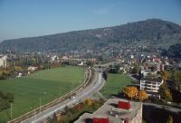
Title (German)
Liestal BL, Oestlicher Teil von Liestal mit dem Südhang Schleifenberg, Stadtzentrum mit dem Südhang Schleifenberg
Caption
South view of the Schleifenberg with Liestal in the foreground (center), end of vegetation phase, first photograph (1989), general view; keywords Documenta Natura: clearing, reforestation, road construction.
Caption (German)
Südansicht des Schleifenbergs mit Liestal im Vordergrund (Zentrum), Ende Vegetationsphase, Erstaufnahme (1989), Gesamtansicht; Schlagworte Documenta Natura: Rodung, Aufforstung, Strassenbau
Record Name
Dia_303-35027

Title (German)
Liestal BL, Oestlicher Teil von Liestal mit dem Südhang Schleifenberg, Stadtzentrum mit dem Südhang Schleifenberg
Caption
Southwest view of the Schleifenberg with Liestal in the foreground (eastern part), end of vegetation phase, first photograph (1989), general view; keywords Documenta Natura: clearing, reforestation, road construction.
Caption (German)
Südwestansicht des Schleifenbergs mit Liestal im Vordergrund (Ostteil), Ende Vegetationsphase, Erstaufnahme (1989), Gesamtansicht; Schlagworte Documenta Natura: Rodung, Aufforstung, Strassenbau
Record Name
Dia_303-35037

Title (German)
Liestal BL, Oestlicher Teil von Liestal mit dem Südhang Schleifenberg, Stadtzentrum mit dem Südhang Schleifenberg
Caption
South view of the Schleifenberg with Liestal in the foreground (center), beginning of vegetation phase, 1st subsequent photograph (1991), general view; keywords Documenta Natura: clearing, reforestation, road construction.
Caption (German)
Südansicht des Schleifenbergs mit Liestal im Vordergrund (Zentrum), Beginn Vegetationsphase, 1. Folgeaufnahme (1991), Gesamtansicht; Schlagworte Documenta Natura: Rodung, Aufforstung, Strassenbau
Record Name
Dia_303-35045

Title (German)
Liestal BL, Oestlicher Teil von Liestal mit dem Südhang Schleifenberg, Stadtzentrum mit dem Südhang Schleifenberg
Caption
Southwest view of the Schleifenberg with Liestal (eastern part), beginning of vegetation phase, 1st follow-up photograph (1991), general view; coordinates (LV03) of camera location: 623175/258675; keywords Documenta Natura: clearing, afforestation, road construction.
Caption (German)
Südwestansicht des Schleifenbergs mit Liestal (Ostteil), Beginn Vegetationsphase, 1. Folgeaufnahme (1991), Gesamtansicht; Koordinaten (LV03) des Kamerastandorts: 623175/258675; Schlagworte Documenta Natura: Rodung, Aufforstung, Strassenbau
Record Name
Dia_303-35055

Title (German)
Liestal BL, Im Wald Schleifenberg unterhalb des Aussichtturmes
Caption
Structure of Schleifenberg forest before thinning (clear-cutting), with machine path, first photograph taken in 1990 without leaves, partial view across the slope; coordinates (LV03) of camera location: 623670/259610; keywords Documenta Natura: clear-cutting, reforestation, road construction.
Caption (German)
Struktur des Waldes Schleifenberg vor der Durchforstung (Kahlschlag), mit Maschinenweg, Erstaufnahme 1990 laublos, Teilansicht quer zum Hang; Koordinaten (LV03) des Kamerastandorts: 623670/259610; Schlagworte Documenta Natura: Rodung, Aufforstung, Strassenbau
Record Name
Dia_303-35076

Title (German)
Liestal BL, Im Wald Schleifenberg unterhalb des Aussichtturmes
Caption
Structure of the Schleifenberg forest before thinning (clear-cutting), with machine path, first photograph taken in 1990 without leaves, partial view across the slope; coordinates (LV03) of camera location: 623630/259630; keywords Documenta Natura: clear-cutting, reforestation, road construction.
Caption (German)
Struktur des Waldes Schleifenberg vor der Durchforstung (Kahlschlag), mit Maschinenweg, Erstaufnahme 1990 laublos, Teilansicht quer zum Hang; Koordinaten (LV03) des Kamerastandorts: 623630/259630; Schlagworte Documenta Natura: Rodung, Aufforstung, Strassenbau
Record Name
Dia_303-35081

Title (German)
Liestal BL, Im Wald Schleifenberg unterhalb des Aussichtturmes
Caption
Structure of the Schleifenberg forest before thinning (clear-cutting), with machine path, first photograph taken in 1990 without leaves, partial view upslope; coordinates (LV03) of camera location: 623630/259630; keywords Documenta Natura: clear-cutting, reforestation, road construction.
Caption (German)
Struktur des Waldes Schleifenberg vor der Durchforstung (Kahlschlag), mit Maschinenweg, Erstaufnahme 1990 laublos, Teilansicht hangaufwärts; Koordinaten (LV03) des Kamerastandorts: 623630/259630; Schlagworte Documenta Natura: Rodung, Aufforstung, Strassenbau
Record Name
Dia_303-35086

Title (German)
Liestal BL, Im Wald Schleifenberg unterhalb des Aussichtturmes
Caption
Structure of the Schleifenberg forest after thinning (clear-cutting), with machine path, first photograph taken in 1990 without leaves, partial view upslope; coordinates (LV03) of camera location: 623670/259610; keywords Documenta Natura: clear-cutting, reforestation, road construction.
Caption (German)
Struktur des Waldes Schleifenberg nach der Durchforstung (Kahlschlag), mit Maschinenweg, Erstaufnahme 1990 laublos, Teilansicht hangaufwärts; Koordinaten (LV03) des Kamerastandorts: 623670/259610; Schlagworte Documenta Natura: Rodung, Aufforstung, Strassenbau
Record Name
Dia_303-35091

Title (German)
Liestal BL, Im Wald Schleifenberg unterhalb des Aussichtturmes
Caption
Structure of the Schleifenberg forest after thinning (clear-cutting), with machine path, first photograph taken in 1990 without leaves, partial view upslope; coordinates (LV03) of camera location: 623630/259630; keywords Documenta Natura: clear-cutting, reforestation, road construction.
Caption (German)
Struktur des Waldes Schleifenberg nach der Durchforstung (Kahlschlag), mit Maschinenweg, Erstaufnahme 1990 laublos, Teilansicht hangaufwärts; Koordinaten (LV03) des Kamerastandorts: 623630/259630; Schlagworte Documenta Natura: Rodung, Aufforstung, Strassenbau
Record Name
Dia_303-35096
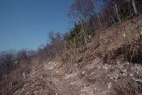
Title (German)
Liestal BL, Im Wald Schleifenberg unterhalb des Aussichtturmes
Caption
Structure of the Schleifenberg forest after thinning (clear-cutting), with machine path, 1st follow-up photograph 1991 leafless, partial view upslope; coordinates (LV03) of camera location: 623630/259630; keywords Documenta Natura: clear-cutting, reforestation, road construction.
Caption (German)
Struktur des Waldes Schleifenberg nach der Durchforstung (Kahlschlag), mit Maschinenweg, 1. Folgeaufnahme 1991 laublos, Teilansicht hangaufwärts; Koordinaten (LV03) des Kamerastandorts: 623630/259630; Schlagworte Documenta Natura: Rodung, Aufforstung, Strassenbau
Record Name
Dia_303-35101

Title (German)
Liestal BL, Wald Schleifenberg, Waldschneise südlich von Schürholden Kreuzung mit Jägerweg
Caption
Forest aisle and existing forest road, first shot with construction machine during excavation of new roadway, general view; coordinates (LV03) of camera location: 622838/259725; keywords Documenta Natura: clearing, reforestation, road construction.
Caption (German)
Waldschneise und bestehender Waldweg, Erstaufnahme mit Baumaschine beim Aushub des neuen Trassees, Gesamtansicht; Koordinaten (LV03) des Kamerastandorts: 622838/259725; Schlagworte Documenta Natura: Rodung, Aufforstung, Strassenbau
Record Name
Dia_303-35106

Title (German)
Liestal BL, Wald Schleifenberg, Waldschneise südlich von Schürholden Kreuzung mit Jägerweg
Caption
Forest aisle and existing forest road, 1st follow-up image with new forest road, machine path, leafless, general view; coordinates (LV03) of camera location: 622838/259725; keywords Documenta Natura: clearing, reforestation, road construction.
Caption (German)
Waldschneise und bestehender Waldweg, 1. Folgeaufnahme mit neuem Waldweg, Maschinenweg, laublos, Gesamtansicht; Koordinaten (LV03) des Kamerastandorts: 622838/259725; Schlagworte Documenta Natura: Rodung, Aufforstung, Strassenbau
Record Name
Dia_303-35112

Title (German)
Liestal BL, Wald Schleifenberg, Jägerweg südlich von Schürholden
Caption
Temporary stone nets suspended vertically from trees, safety measure during forest road construction, partial view; keywords Documenta Natura: clearing, reforestation, road construction.
Caption (German)
An Bäumen vertikal aufgehängte provisorische Steinnetze, Sicherheitsmassnahme während dem Waldstrassenbau, Teilansicht; Schlagworte Documenta Natura: Rodung, Aufforstung, Strassenbau
Record Name
Dia_303-35121

Title (German)
Liestal BL, Wald Schleifenberg, Jägerweg südlich von Schürholden
Caption
Temporary stone nets suspended vertically from trees, safety measure during forest road construction, partial view; keywords Documenta Natura: clearing, reforestation, road construction.
Caption (German)
An Bäumen vertikal aufgehängte provisorische Steinnetze, Sicherheitsmassnahme während dem Waldstrassenbau, Teilansicht; Schlagworte Documenta Natura: Rodung, Aufforstung, Strassenbau
Record Name
Dia_303-35125

Title (German)
Liestal BL, Wald Schleifenberg, neuer Waldweg südlich von Schürholden
Caption
New route of the created forest road, general view; keywords Documenta Natura: clearing, reforestation, road construction.
Caption (German)
Neues Trassee des erstellten Waldweges, Gesamtansicht; Schlagworte Documenta Natura: Rodung, Aufforstung, Strassenbau
Record Name
Dia_303-35128

Title (German)
Liestal BL, Wald Schleifenberg, neuer Waldweg südlich von Schürholden
Caption
New route of the created forest road, general view; keywords Documenta Natura: clearing, reforestation, road construction.
Caption (German)
Neues Trassee des erstellten Waldweges, Gesamtansicht; Schlagworte Documenta Natura: Rodung, Aufforstung, Strassenbau
Record Name
Dia_303-35130

Title (German)
Liestal BL, Wald Schleifenberg, neuer Waldweg südlich von Schürholden
Caption
Prepared forest aisle with excavation, general view; keywords Documenta Natura: clearing, reforestation, road construction.
Caption (German)
Vorbereitete Waldschneise mit Aushub, Gesamtansicht; Schlagworte Documenta Natura: Rodung, Aufforstung, Strassenbau
Record Name
Dia_303-35133

Title (German)
Liestal BL, Wald Schleifenberg, neuer Waldweg südlich von Schürholden
Caption
Excavator digging the road case, general view; keywords Documenta Natura: clearing, reforestation, road construction
Caption (German)
Bagger am Ausheben des Strassenkoffer, Gesamtansicht; Schlagworte Documenta Natura: Rodung, Aufforstung, Strassenbau
Record Name
Dia_303-35138
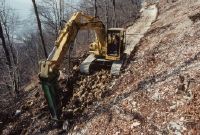
Title (German)
Liestal BL, Wald Schleifenberg, neuer Waldweg südlich von Schürholden
Caption
Excavator with hammer head preparing the road case, general view; keywords Documenta Natura: clearing, reforestation, road construction
Caption (German)
Bagger mit Hammerkopf am Vorbereiten des Strassenkoffer, Gesamtansicht; Schlagworte Documenta Natura: Rodung, Aufforstung, Strassenbau
Record Name
Dia_303-35148

Title (German)
Liestal BL, Wald Schleifenberg, neuer Waldweg südlich von Schürholden
Caption
Excavator with hammer head preparing the road case, partial view; keywords Documenta Natura: clearing, reforestation, road construction
Caption (German)
Bagger mit Hammerkopf am Vorbereiten des Strassenkoffer, Teilansicht; Schlagworte Documenta Natura: Rodung, Aufforstung, Strassenbau
Record Name
Dia_303-35150

Title (German)
Liestal BL, Wald Schleifenberg, neuer Waldweg südlich von Schürholden
Caption
Excavator digging the road case, general view; keywords Documenta Natura: clearing, reforestation, road construction
Caption (German)
Bagger am Ausheben des Strassenkoffer, Gesamtansicht; Schlagworte Documenta Natura: Rodung, Aufforstung, Strassenbau
Record Name
Dia_303-35157

Title (German)
Liestal BL, Wald Schleifenberg, neuer Waldweg südlich von Schürholden
Caption
Shovel excavator excavating and loading the removed material onto trucks, general view; keywords Documenta Natura: clearing, reforestation, road construction
Caption (German)
Schaufelbagger am Ausheben und Verladen des abgetragenen Materials auf Lastwagen, Gesamtansicht; Schlagworte Documenta Natura: Rodung, Aufforstung, Strassenbau
Record Name
Dia_303-35165

Title (German)
Liestal BL, Wald Schleifenberg, neuer Waldweg südlich von Schürholden
Caption
Shovel excavator excavating and loading the removed material onto trucks, general view; keywords Documenta Natura: clearing, reforestation, road construction
Caption (German)
Schaufelbagger am Ausheben und Verladen des abgetragenen Materials auf Lastwagen, Gesamtansicht; Schlagworte Documenta Natura: Rodung, Aufforstung, Strassenbau
Record Name
Dia_303-35170

Title (German)
Liestal BL, Wald Schleifenberg, neuer Waldweg südlich von Schürholden
Caption
Shovel excavator excavating and loading the removed material onto trucks, general view; keywords Documenta Natura: clearing, reforestation, road construction
Caption (German)
Schaufelbagger am Ausheben und Verladen des abgetragenen Materials auf Lastwagen, Gesamtansicht; Schlagworte Documenta Natura: Rodung, Aufforstung, Strassenbau
Record Name
Dia_303-35174

Title (German)
Liestal BL, Wald Schleifenberg, neuer Waldweg südlich von Schürholden
Caption
Shovel excavator loading the removed material onto trucks, partial view; keywords Documenta Natura: clearing, reforestation, road construction
Caption (German)
Schaufelbagger am Verladen des abgetragenen Materials auf Lastwagen, Teilansicht; Schlagworte Documenta Natura: Rodung, Aufforstung, Strassenbau
Record Name
Dia_303-35182

Title (German)
Risch ZG, Südansicht des Kathrinenhofes südlich von Holzhäusern
Caption
South view of Kathrinenhof with dwelling house and farm buildings, farmland and meadowland, first photograph (1994), general view; coordinates (LV03) of camera location: 676095/222455; keywords Documenta Natura: golf, lowland, landfill, landscape change.
Caption (German)
Südansicht des Kathrinenhofes mit Wohnhaus und Wirtschaftsbauten, Ackerland und Wiesland, Erstaufnahme (1994), Gesamtansicht; Koordinaten (LV03) des Kamerastandorts: 676095/222455; Schlagworte Documenta Natura: Golf, Flachland, Abfalldeponie, Landschaftswandel
Record Name
Dia_303-35190

Title (German)
Risch ZG, Südansicht des Kathrinenhofes südlich von Holzhäusern
Caption
South view of Kathrinenhof, 1st follow-up photo with new construction of park restaurant and clubhouse (renovated), parking lot and newly planted trees (1996), general view; coordinates (LV03) of camera location: 676095/222455; keywords Documenta Natura: golf, lowland, landfill, landscape change.
Caption (German)
Südansicht des Kathrinenhofes, 1. Folgeaufnahme mit Neubau des Park Restaurants und Clubhauses (renoviert), Parkplatz und neu gepflanzten Bäumen (1996), Gesamtansicht; Koordinaten (LV03) des Kamerastandorts: 676095/222455; Schlagworte Documenta Natura: Golf, Flachland, Abfalldeponie, Landschaftswandel
Record Name
Dia_303-35200
Title (German)
Risch ZG, Golfpark zwischen Buonas und Holzhäusern, im Hintergrund der Kathrinenhof und der Hof Obere Freudenberg
Caption
Intensively used cultural landscape near Holzhäusern with fruit trees, farmland, meadowland, road, with SBB line, first photograph (1994), partial view; coordinates (LV03) of camera location: 676875/222580; keywords Documenta Natura: golf, lowland, waste disposal site, landscape change.
Caption (German)
Intensiv genutzte Kulturlandschaft bei Holzhäusern mit Obstbäumen, Ackerland, Wiesland, Strasse, mit SBB-Linie, Erstaufnahme (1994), Teilansicht; Koordinaten (LV03) des Kamerastandorts: 676875/222580; Schlagworte Documenta Natura: Golf, Flachland, Abfalldeponie, Landschaftswandel
Record Name
Dia_303-35210

Title (German)
Risch ZG, Golfpark zwischen Buonas und Holzhäusern, im Hintergrund der Kathrinenhof und der Hof Obere Freudenberg
Caption
Intensively used cultural landscape near Holzhäusern with arable land, meadowland, in the background the Kathrinenhof and the Obere Freudenberg farm, first photograph (1994), partial view; coordinates (LV03) of the camera location: 676875/222580; keywords Documenta Natura: golf, lowland, waste disposal site, landscape change.
Caption (German)
Intensiv genutzte Kulturlandschaft bei Holzhäusern mit Ackerland, Wiesland, im Hintergrund der Kathrinenhof und der Hof Obere Freudenberg, Erstaufnahme (1994), Teilansicht; Koordinaten (LV03) des Kamerastandorts: 676875/222580; Schlagworte Documenta Natura: Golf, Flachland, Abfalldeponie, Landschaftswandel
Record Name
Dia_303-35220

Title (German)
Risch ZG, Golfpark zwischen Buonas und Holzhäusern, im Hintergrund der Kathrinenhof und der Hof Obere Freudenberg
Caption
Cultural landscape near Holzhäusern, 1st follow-up photograph after the construction of the golf park with fruit trees, newly planted shrubs, protective nets (1996), partial view; coordinates (LV03) of the camera location: 676875/222580; keywords Documenta Natura: golf, lowland, landfill, landscape change.
Caption (German)
Kulturlandschaft bei Holzhäusern, 1. Folgeaufnahme nach dem Bau des Golfparkes mit Obstbäumen, neu gepflanzten Sträuchern, Schutznetzen (1996), Teilansicht; Koordinaten (LV03) des Kamerastandorts: 676875/222580; Schlagworte Documenta Natura: Golf, Flachland, Abfalldeponie, Landschaftswandel
Record Name
Dia_303-35230

Title (German)
Risch ZG, Golfpark zwischen Buonas und Holzhäusern, im Hintergrund der Kathrinenhof und der Hof Obere Freudenberg
Caption
Cultural landscape near Holzhäusern, 1st follow-up photograph after the construction of the golf park with fruit trees, newly planted shrubs, protective nets (1996), partial view; coordinates (LV03) of the camera location: 676875/222580; keywords Documenta Natura: golf, lowland, landfill, landscape change.
Caption (German)
Kulturlandschaft bei Holzhäusern, 1. Folgeaufnahme nach dem Bau des Golfparkes mit Obstbäumen, neu gepflanzten Sträuchern, Schutznetzen (1996), Teilansicht; Koordinaten (LV03) des Kamerastandorts: 676875/222580; Schlagworte Documenta Natura: Golf, Flachland, Abfalldeponie, Landschaftswandel
Record Name
Dia_303-35240

Title (German)
Hünenberg ZG, Risch ZG, Südsüdostansicht von Holzhäusern, im Vordergrund die Golfanlage, Wiesen, Obstbäume, Strasse und Stall, im Hintergrund die Gewerbezone Bösch-Ost
Caption
South-southeast view of wooden houses, with meadows, fruit trees, stables, in the background the industrial zone Bösch-Ost, first photograph (1994), partial view; coordinates (LV03) of the camera location: 676180/222975; keywords Documenta Natura: golf, lowland, waste disposal site, landscape change.
Caption (German)
Südsüdostansicht von Holzhäusern, mit Wiesen, Obstbäume, Stallungen, im Hintergrund die Gewerbezone Bösch-Ost, Erstaufnahme (1994), Teilansicht; Koordinaten (LV03) des Kamerastandorts: 676180/222975; Schlagworte Documenta Natura: Golf, Flachland, Abfalldeponie, Landschaftswandel
Record Name
Dia_303-35251

Title (German)
Hünenberg ZG, Risch ZG, Südsüdostansicht von Holzhäusern, im Vordergrund die Golfanlage, Wiesen, Obstbäume, Strasse und Stall, im Hintergrund die Gewerbezone Bösch-Ost
Caption
South-southeast view of wooden houses, with meadows, fruit trees, stables, in the background the industrial zone Bösch-Ost, first photograph (1994), partial view; coordinates (LV03) of the camera location: 676180/222975; keywords Documenta Natura: golf, lowland, waste disposal site, landscape change.
Caption (German)
Südsüdostansicht von Holzhäusern, mit Wiesen, Obstbäume, Stallungen, im Hintergrund die Gewerbezone Bösch-Ost, Erstaufnahme (1994), Teilansicht; Koordinaten (LV03) des Kamerastandorts: 676180/222975; Schlagworte Documenta Natura: Golf, Flachland, Abfalldeponie, Landschaftswandel
Record Name
Dia_303-35261
Title (German)
Hünenberg ZG, Risch ZG, Südsüdostansicht von Holzhäusern, im Vordergrund die Golfanlage, Wiesen, Obstbäume, Strasse und Stall, im Hintergrund die Gewerbezone Bösch-Ost
Caption
South-southeast view of Holzhäusern, in the background the commercial zone Bösch-Ost, 1st subsequent photograph after the construction of the golf park, in the foreground tee of course 9 and footpath (1996), partial view; coordinates (LV03) of the camera location: 676180/222975; keywords Documenta Natura: golf, lowland, landfill, landscape change
Caption (German)
Südsüdostansicht von Holzhäusern, im Hintergrund die Gewerbezone Bösch-Ost, 1. Folgeaufnahme nach dem Bau des Golfparkes, im Vordergrund Abschlag der Bahn 9 und Fussweg (1996), Teilansicht; Koordinaten (LV03) des Kamerastandorts: 676180/222975; Schlagworte Documenta Natura: Golf, Flachland, Abfalldeponie, Landschaftswandel
Record Name
Dia_303-35271
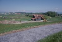
Title (German)
Hünenberg ZG, Risch ZG, Südsüdostansicht von Holzhäusern, im Vordergrund die Golfanlage, Wiesen, Obstbäume, Strasse und Stall, im Hintergrund die Gewerbezone Bösch-Ost
Caption
South-southeast view of Holzhäusern, in the background the commercial zone Bösch-Ost, 1st subsequent photograph after the construction of the golf park, in the foreground footpath and railroad 16 (1996), partial view; coordinates (LV03) of the camera location: 676180/222975; keywords Documenta Natura: golf, lowland, waste disposal site, landscape change
Caption (German)
Südsüdostansicht von Holzhäusern, im Hintergrund die Gewerbezone Bösch-Ost, 1. Folgeaufnahme nach dem Bau des Golfparkes, im Vordergrund Fussweg und Bahn 16 (1996), Teilansicht; Koordinaten (LV03) des Kamerastandorts: 676180/222975; Schlagworte Documenta Natura: Golf, Flachland, Abfalldeponie, Landschaftswandel
Record Name
Dia_303-35281

Title (German)
Risch ZG, Auf Golfanlage in Waldlichtung zwischen Oberer Freudenberg und Unterer Freudenberg
Caption
Wet meadow in forest clearing, Alznach landfill in the background, first photograph (1994), partial view; coordinates (LV03) of camera location: 676825/223145; keywords Documenta Natura: golf, lowland, landfill, landscape change.
Caption (German)
Feuchtwiese in Waldlichtung, im Hintergrund die Abfalldeponie Alznach, Erstaufnahme (1994), Teilansicht; Koordinaten (LV03) des Kamerastandorts: 676825/223145; Schlagworte Documenta Natura: Golf, Flachland, Abfalldeponie, Landschaftswandel
Record Name
Dia_303-35292

Title (German)
Risch ZG, Auf Golfanlage in Waldlichtung zwischen Oberer Freudenberg und Unterer Freudenberg
Caption
Reduced wet meadow in forest clearing, 1st follow-up photograph after the construction of the golf park with course 13, in the foreground the women's tee, in the background the former Alznach landfill (1996), partial view; coordinates (LV03) of the camera location: 676825/223145; keywords Documenta Natura: golf, lowland, landfill, landscape change.
Caption (German)
Reduzierte Feuchtwiese in Waldlichtung, 1. Folgeaufnahme nach dem Bau des Golfparkes mit der Bahn 13, im Vordergrund der Frauenabschlag, im Hintergrund die ehemalige Abfalldeponie Alznach (1996), Teilansicht; Koordinaten (LV03) des Kamerastandorts: 676825/223145; Schlagworte Documenta Natura: Golf, Flachland, Abfalldeponie, Landschaftswandel
Record Name
Dia_303-35302

Title (German)
Risch ZG, Südansicht der Abfalldeponie Alznach südlich von Alznach, im Hintergrund Dersbach
Caption
South view of the open waste dump Alznach, in the background the railroad line of the SBB and Dersbach, first photograph (1994), partial view; coordinates (LV03) of the camera location: 676525/223240; keywords Documenta Natura: golf, lowland, waste dump, landscape change.
Caption (German)
Südansicht der offenen Abfalldeponie Alznach, im Hintergrund die Bahnlinie der SBB und Dersbach, Erstaufnahme (1994), Teilansicht; Koordinaten (LV03) des Kamerastandorts: 676525/223240; Schlagworte Documenta Natura: Golf, Flachland, Abfalldeponie, Landschaftswandel
Record Name
Dia_303-35313

Title (German)
Risch ZG, Südansicht der Abfalldeponie Alznach südlich von Alznach, im Hintergrund Dersbach
Caption
South view of the waste disposal site Alznach, in the background the railroad line of the SBB and Dersbach, 1st subsequent photograph after the construction of the golf park Holzhäusern with fairway of course 14, with reduced landfill (1996), partial view; coordinates (LV03) of the camera location: 676525/223240; keywords Documenta Natura: golf, lowland, waste disposal site, landscape change
Caption (German)
Südansicht der Abfalldeponie Alznach, im Hintergrund die Bahnlinie der SBB und Dersbach, 1. Folgeaufnahme nach dem Bau des Golfparkes Holzhäusern mit Fairway der Bahn 14, mit verkleinerter Deponie (1996), Teilansicht; Koordinaten (LV03) des Kamerastandorts: 676525/223240; Schlagworte Documenta Natura: Golf, Flachland, Abfalldeponie, Landschaftswandel
Record Name
Dia_303-35323

Title (German)
Risch ZG, Auf Golfanlage südöstlich von Holzhäusern, im Hintergrund der Zugersee und Zugerberg
Caption
Intensively used cultivated landscape near Holzhäusern with fruit trees, meadow and arable land, in the background Lake Zug and Zugerberg, first photograph (1994), partial view; coordinates (LV03) of camera location: 676180/222975; keywords Documenta Natura: golf, lowland, landfill, landscape change
Caption (German)
Intensiv genutzte Kulturlandschaft bei Holzhäusern mit Obstbäumen, Wies- und Ackerland, im Hintergrund der Zugersee und Zugerberg, Erstaufnahme (1994), Teilansicht; Koordinaten (LV03) des Kamerastandorts: 676180/222975; Schlagworte Documenta Natura: Golf, Flachland, Abfalldeponie, Landschaftswandel
Record Name
Dia_303-35334

Title (German)
Risch ZG, Auf Golfanlage südöstlich von Holzhäusern, im Hintergrund der Zugersee und Zugerberg
Caption
Cultural landscape near Holzhäusern, 1st follow-up photograph after the construction of the golf park with the tee of course 17, with newly planted shrubs, view of Lake Zug and Zugerberg (1996), partial view; coordinates (LV03) of the camera location: 676180/222975; keywords Documenta Natura: golf, lowland, landfill, landscape change
Caption (German)
Kulturlandschaft bei Holzhäusern, 1. Folgeaufnahme nach dem Bau des Golfparkes mit dem Abschlag der Bahn 17, mit neu gepflanzten Sträuchern, Sicht auf Zugersee und Zugerberg (1996), Teilansicht; Koordinaten (LV03) des Kamerastandorts: 676180/222975; Schlagworte Documenta Natura: Golf, Flachland, Abfalldeponie, Landschaftswandel
Record Name
Dia_303-35344

Title (German)
Risch ZG, Auf Golfanlage südöstlich von Holzhäusern mit dem Kathrinenhof, im Hintergrund der Zugerberg, Buonas und Rigi
Caption
Intensively used cultural landscape near Holzhäusern with hedge, meadow and arable land, in the background the Zugerberg, first photograph (1994), partial view; coordinates (LV03) of the camera location: 676060/222928; keywords Documenta Natura: golf, lowland, waste disposal site, landscape change.
Caption (German)
Intensiv genutzte Kulturlandschaft bei Holzhäusern mit Hecke, Wies- und Ackerland, im Hintergrund der Zugerberg, Erstaufnahme (1994), Teilansicht; Koordinaten (LV03) des Kamerastandorts: 676060/222928; Schlagworte Documenta Natura: Golf, Flachland, Abfalldeponie, Landschaftswandel
Record Name
Dia_303-35355

Title (German)
Risch ZG, Auf Golfanlage südöstlich von Holzhäusern mit dem Kathrinenhof, im Hintergrund der Zugerberg, Buonas und Rigi
Caption
Intensively used cultural landscape near Holzhäusern with meadowland, farmland and the Kathrinenhof, in the background the roofs of Buonas and the Rigi, first photograph (1994), partial view; coordinates (LV03) of the camera location: 676060/222928; keywords Documenta Natura: golf, lowland, waste disposal site, landscape change
Caption (German)
Intensiv genutzte Kulturlandschaft bei Holzhäusern mit Wies-, Ackerland und dem Kathrinenhof, im Hintergrund die Dächer von Buonas und die Rigi, Erstaufnahme (1994), Teilansicht; Koordinaten (LV03) des Kamerastandorts: 676060/222928; Schlagworte Documenta Natura: Golf, Flachland, Abfalldeponie, Landschaftswandel
Record Name
Dia_303-35365

Title (German)
Risch ZG, Auf Golfanlage südöstlich von Holzhäusern mit dem Kathrinenhof, im Hintergrund der Zugerberg, Buonas und Rigi
Caption
Cultural landscape near Holzhäusern, in the background the Zugerberg, 1st subsequent photograph after the construction of the golf park with holes 9, 1 and 17 (golf course) (1996), partial view; coordinates (LV03) of the camera location: 676060/222928; keywords Documenta Natura: golf, lowland, landfill, landscape change
Caption (German)
Kulturlandschaft bei Holzhäusern, im Hintergrund der Zugerberg, 1. Folgeaufnahme nach dem Bau des Golfparkes mit den Bahnen 9, 1 und 17 (Golfanlage) (1996), Teilansicht; Koordinaten (LV03) des Kamerastandorts: 676060/222928; Schlagworte Documenta Natura: Golf, Flachland, Abfalldeponie, Landschaftswandel
Record Name
Dia_303-35375

Title (German)
Risch ZG, Auf Golfanlage südöstlich von Holzhäusern mit dem Kathrinenhof, im Hintergrund der Zugerberg, Buonas und Rigi
Caption
Cultural landscape near Holzhäusern, in the background the Rigi, 1st subsequent photograph after the construction of the golf park, Kathrinenhof with new building of the park restaurant (1996), partial view; coordinates (LV03) of the camera location: 676060/222928; keywords Documenta Natura: golf, lowland, waste disposal site, landscape change
Caption (German)
Kulturlandschaft bei Holzhäusern, im Hintergrund die Rigi, 1. Folgeaufnahme nach dem Bau des Golfparkes, Kathrinenhof mit Neubau des Park Restaurants (1996), Teilansicht; Koordinaten (LV03) des Kamerastandorts: 676060/222928; Schlagworte Documenta Natura: Golf, Flachland, Abfalldeponie, Landschaftswandel
Record Name
Dia_303-35385

Title (German)
Risch ZG, Auf Golfanlage (Greens von Bahn 16 und 9) zwischen Holzhäusern Kathrinenhof
Caption
Flowering pasture, meadow, in the background plowed farmland and flowering rape field, first shot of the planned railroad 9 (1994) partial view; coordinates (LV03) of the camera location: 676015/222645; keywords Documenta Natura: golf, lowland, landfill, landscape change.
Caption (German)
Blühende Weide, Wiese, im Hintergrund gepflügtes Ackerland und blühendes Rapsfeld, Erstaufnahme der geplanten Bahn 9 (1994) Teilansicht; Koordinaten (LV03) des Kamerastandorts: 676015/222645; Schlagworte Documenta Natura: Golf, Flachland, Abfalldeponie, Landschaftswandel
Record Name
Dia_303-35396

Title (German)
Risch ZG, Auf Golfanlage (Greens von Bahn 16 und 9) zwischen Holzhäusern Kathrinenhof
Caption
Flowering pasture, meadow, first photograph of the planned railroad 16 (1994) partial view; coordinates (LV03) of the camera location: 676135/223025; keywords Documenta Natura: golf, lowland, landfill, landscape change.
Caption (German)
Blühende Weide, Wiese, Erstaufnahme der geplanten Bahn 16 (1994) Teilansicht; Koordinaten (LV03) des Kamerastandorts: 676135/223025; Schlagworte Documenta Natura: Golf, Flachland, Abfalldeponie, Landschaftswandel
Record Name
Dia_303-35406

Title (German)
Risch ZG, Auf Golfanlage (Greens von Bahn 16 und 9) zwischen Holzhäusern Kathrinenhof
Caption
Construction of the golf park, 1st follow-up shot with gravel and coffer material laid out for course 9, fallow farmland in the background, partial view; coordinates (LV03) of camera location: 676015/222645; keywords Documenta Natura: golf, lowland, landfill, landscape change.
Caption (German)
Bau des Golfparkes, 1. Folgeaufnahme mit ausgelegtem Kies und Koffermaterial für Bahn 9, im Hintergrund braches Ackerland, Teilansicht; Koordinaten (LV03) des Kamerastandorts: 676015/222645; Schlagworte Documenta Natura: Golf, Flachland, Abfalldeponie, Landschaftswandel
Record Name
Dia_303-35416

Title (German)
Risch ZG, Auf Golfanlage (Greens von Bahn 16 und 9) zwischen Holzhäusern Kathrinenhof
Caption
Construction of the golf park, 1st follow-up shot with gravel and coffer material laid out for course 16, fallow farmland in the background, partial view; coordinates (LV03) of camera location: 676135/223025; keywords Documenta Natura: golf, lowland, landfill, landscape change.
Caption (German)
Bau des Golfparkes, 1. Folgeaufnahme mit ausgelegtem Kies und Koffermaterial für Bahn 16, im Hintergrund braches Ackerland, Teilansicht; Koordinaten (LV03) des Kamerastandorts: 676135/223025; Schlagworte Documenta Natura: Golf, Flachland, Abfalldeponie, Landschaftswandel
Record Name
Dia_303-35427

Title (German)
Risch ZG, Auf Golfanlage (Greens von Bahn 16 und 9) zwischen Holzhäusern Kathrinenhof
Caption
Golf park in operation, 2nd follow-up photograph with the green of course 9 (1996), partial view; coordinates (LV03) of camera location: 676015/222645; keywords Documenta Natura: golf, lowland, landfill, landscape change.
Caption (German)
Golfpark in Betrieb, 2. Folgeaufnahme mit dem Green der Bahn 9 (1996), Teilansicht; Koordinaten (LV03) des Kamerastandorts: 676015/222645; Schlagworte Documenta Natura: Golf, Flachland, Abfalldeponie, Landschaftswandel
Record Name
Dia_303-35436

Title (German)
Risch ZG, Auf Golfanlage (Greens von Bahn 16 und 9) zwischen Holzhäusern Kathrinenhof
Caption
Golf park in operation, 2nd follow-up shot with the green of course 16, greenkeeper maintaining with machines (1996), partial view; coordinates (LV03) of camera location: 676135/223025; keywords Documenta Natura: golf, lowland, landfill, landscape change.
Caption (German)
Golfpark in Betrieb, 2. Folgeaufnahme mit dem Green der Bahn 16, Greenkeeper beim Pflegen mit Maschinen (1996), Teilansicht; Koordinaten (LV03) des Kamerastandorts: 676135/223025; Schlagworte Documenta Natura: Golf, Flachland, Abfalldeponie, Landschaftswandel
Record Name
Dia_303-35447

Title (German)
Risch ZG, Auf Golfanlage (Abschläge von Bahn 9 und 1) zwischen Holzhäusern Kathrinenhof
Caption
Flowering pasture, meadow, in the background plowed farmland and flowering rape field, first shot of the planned tee for course 1 (1994), partial view; coordinates (LV03) of the camera location: 676078/222613; keywords Documenta Natura: golf, lowland, landfill, landscape change.
Caption (German)
Blühende Weide, Wiese, im Hintergrund gepflügtes Ackerland und blühendes Rapsfeld, Erstaufnahme des geplanten Abschlages für Bahn 1 (1994), Teilansicht; Koordinaten (LV03) des Kamerastandorts: 676078/222613; Schlagworte Documenta Natura: Golf, Flachland, Abfalldeponie, Landschaftswandel
Record Name
Dia_303-35458

Title (German)
Risch ZG, Auf Golfanlage (Abschläge von Bahn 9 und 1) zwischen Holzhäusern Kathrinenhof
Caption
Flowering willow, meadow, first photograph of the planned tee for course 9 (1994), partial view; coordinates (LV03) of camera location: 676110/223020; keywords Documenta Natura: golf, lowland, waste disposal site, landscape change.
Caption (German)
Blühende Weide, Wiese, Erstaufnahme des geplanten Abschlages für Bahn 9 (1994), Teilansicht; Koordinaten (LV03) des Kamerastandorts: 676110/223020; Schlagworte Documenta Natura: Golf, Flachland, Abfalldeponie, Landschaftswandel
Record Name
Dia_303-35468
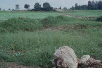
Title (German)
Risch ZG, Auf Golfanlage (Abschläge von Bahn 9 und 1) zwischen Holzhäusern Kathrinenhof
Caption
Construction of the golf park, 1st follow-up photo, construction of the tee for course 1 (1994), partial view; coordinates (LV03) of the camera location: 676078/222613; keywords Documenta Natura: golf, lowland, landfill, landscape change.
Caption (German)
Bau des Golfparkes, 1. Folgeaufnahme, Bau des Abschlages für Bahn 1 (1994), Teilansicht; Koordinaten (LV03) des Kamerastandorts: 676078/222613; Schlagworte Documenta Natura: Golf, Flachland, Abfalldeponie, Landschaftswandel
Record Name
Dia_303-35478

Title (German)
Risch ZG, Auf Golfanlage (Abschläge von Bahn 9 und 1) zwischen Holzhäusern Kathrinenhof
Caption
Construction of the golf park, 1st follow-up photo, construction of the tee for hole 9 (1994), partial view; coordinates (LV03) of the camera location: 676110/223020; keywords Documenta Natura: golf, lowland, landfill, landscape change.
Caption (German)
Bau des Golfparkes, 1. Folgeaufnahme, Bau des Abschlages für Bahn 9 (1994), Teilansicht; Koordinaten (LV03) des Kamerastandorts: 676110/223020; Schlagworte Documenta Natura: Golf, Flachland, Abfalldeponie, Landschaftswandel
Record Name
Dia_303-35488

Title (German)
Risch ZG, Auf Golfanlage (Abschläge von Bahn 9 und 1) zwischen Holzhäusern Kathrinenhof
Caption
Golf park in operation, 2nd follow-up photograph, tee for hole 1 (1996), partial view; coordinates (LV03) of camera location: 676078/222613; keywords Documenta Natura: golf, lowland, landfill, landscape change.
Caption (German)
Golfpark in Betrieb, 2. Folgeaufnahme, Abschlag für Bahn 1 (1996), Teilansicht; Koordinaten (LV03) des Kamerastandorts: 676078/222613; Schlagworte Documenta Natura: Golf, Flachland, Abfalldeponie, Landschaftswandel
Record Name
Dia_303-35498

Title (German)
Risch ZG, Auf Golfanlage (Abschläge von Bahn 9 und 1) zwischen Holzhäusern Kathrinenhof
Caption
Golf park in operation, 2nd follow-up photograph, tee for hole 9 (1996), partial view; coordinates (LV03) of camera location: 676110/223020; keywords Documenta Natura: golf, lowland, landfill, landscape change.
Caption (German)
Golfpark in Betrieb, 2. Folgeaufnahme, Abschlages für Bahn 9 (1996), Teilansicht; Koordinaten (LV03) des Kamerastandorts: 676110/223020; Schlagworte Documenta Natura: Golf, Flachland, Abfalldeponie, Landschaftswandel
Record Name
Dia_303-35508

Title (German)
Risch ZG, Auf Golfanlage nordöstlich des Hofes Obere Freudenberg
Caption
Pasture, meadow with fruit trees, in the background the edge of the forest, the railroad line of the SBB and the farm Untere Freudenberg, first photo (1994), general view; coordinates (LV03) of the camera location: 676725/222955; keywords Documenta Natura: golf, lowland, waste dump, landscape change.
Caption (German)
Weide, Wiese mit Obstbäumen, im Hintergrund der Waldrand, die Bahnlinie der SBB und der Hof Untere Freudenberg, Erstaufnahme (1994), Gesamtansicht; Koordinaten (LV03) des Kamerastandorts: 676725/222955; Schlagworte Documenta Natura: Golf, Flachland, Abfalldeponie, Landschaftswandel
Record Name
Dia_303-35520

Title (German)
Risch ZG, Auf Golfanlage nordöstlich des Hofes Obere Freudenberg
Caption
Meadow with fruit trees, in the background the farm Untere Freudenberg, 1st follow-up shot during the construction of the golf park with freshly excavated and lined hollow for artificial pond (1994), general view; coordinates (LV03) of the camera location: 676725/222955; keywords Documenta Natura: golf, lowland, landfill, landscape change.
Caption (German)
Wiese mit Obstbäumen, im Hintergrund der Hof Untere Freudenberg, 1. Folgeaufnahme während dem Bau des Golfparkes mit frisch ausgehobener und ausgekleideter Mulde für künstlichen Teich (1994), Gesamtansicht; Koordinaten (LV03) des Kamerastandorts: 676725/222955; Schlagworte Documenta Natura: Golf, Flachland, Abfalldeponie, Landschaftswandel
Record Name
Dia_303-35530

Title (German)
Risch ZG, Auf Golfanlage nordöstlich des Hofes Obere Freudenberg
Caption
Meadow with fruit trees, in the background the farm Untere Freudenberg, 2nd subsequent photograph after the construction of the golf park with a small artificial pond and the greens of holes 3 and 12 (1996), general view; coordinates (LV03) of the camera location: 676725/222955; keywords Documenta Natura: golf, lowland, landfill, landscape change
Caption (German)
Wiese mit Obstbäumen, im Hintergrund der Hof Untere Freudenberg, 2. Folgeaufnahme nach dem Bau des Golfparkes mit kleinem künstlichen Teich und den Greens der Bahnen 3 und 12 (1996), Gesamtansicht; Koordinaten (LV03) des Kamerastandorts: 676725/222955; Schlagworte Documenta Natura: Golf, Flachland, Abfalldeponie, Landschaftswandel
Record Name
Dia_303-35540

Title (German)
Risch ZG, Im M-Golfpark Holzhäusern
Caption
M-Golfpark Holzhäusern with the park restaurant, golfers putting, partial view; keywords Documenta Natura: golf, flatland, landfill, landscape change.
Caption (German)
M-Golfparkes Holzhäusern mit dem Park Restaurant, Golfspielern beim Einlochen, Teilansicht; Schlagworte Documenta Natura: Golf, Flachland, Abfalldeponie, Landschaftswandel
Record Name
Dia_303-35551
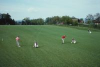
Title (German)
Risch ZG, Im M-Golfpark Holzhäusern
Caption
Golf course with isolated players teeing off and putting in, partial view; Keywords Documenta Natura: golf, lowland, landfill, landscape change.
Caption (German)
Golfanlage mit vereinzelten Spielern beim Abschlagen und Einlochen, Teilansicht; Schlagworte Documenta Natura: Golf, Flachland, Abfalldeponie, Landschaftswandel
Record Name
Dia_303-35553

Title (German)
Risch ZG, Im M-Golfpark Holzhäusern
Caption
Golf course with isolated players teeing off and putting in, partial view; Keywords Documenta Natura: golf, lowland, landfill, landscape change.
Caption (German)
Golfanlage mit vereinzelten Spielern beim Abschlagen und Einlochen, Teilansicht; Schlagworte Documenta Natura: Golf, Flachland, Abfalldeponie, Landschaftswandel
Record Name
Dia_303-35556

Title (German)
Risch ZG, Im M-Golfpark Holzhäusern
Caption
Golf course with isolated players teeing off and putting in, connecting path and planted fruit trees, partial view; Keywords Documenta Natura: golf, lowland, landfill, landscape change.
Caption (German)
Golfanlage mit vereinzelten Spielern beim Abschlagen und Einlochen, Verbindungsweg und gepflanzte Obstbäume, Teilansicht; Schlagworte Documenta Natura: Golf, Flachland, Abfalldeponie, Landschaftswandel
Record Name
Dia_303-35563

Title (German)
Risch ZG, Im M-Golfpark Holzhäusern
Caption
Golf course with isolated players teeing off, planted fruit trees, partial view; Keywords Documenta Natura: golf, lowland, landfill, landscape change.
Caption (German)
Golfanlage mit vereinzelten Spielern beim Abschlagen, gepflanzte Obstbäume, Teilansicht; Schlagworte Documenta Natura: Golf, Flachland, Abfalldeponie, Landschaftswandel
Record Name
Dia_303-35574

Title (German)
Risch ZG, Im M-Golfpark Holzhäusern
Caption
Golf course with isolated players teeing off, planted fruit trees, partial view; Keywords Documenta Natura: golf, lowland, landfill, landscape change.
Caption (German)
Golfanlage mit vereinzelten Spielern beim Abschlagen, gepflanzte Obstbäume, Teilansicht; Schlagworte Documenta Natura: Golf, Flachland, Abfalldeponie, Landschaftswandel
Record Name
Dia_303-35577
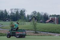
Title (German)
Risch ZG, Im M-Golfpark Holzhäusern
Caption
Greenkeeper maintaining the greens with special machine, partial view; keywords Documenta Natura: golf, lowland, waste disposal site, landscape change
Caption (German)
Greenkeeper beim Pflegen der Greens mit Spezialmaschine, Teilansicht; Schlagworte Documenta Natura: Golf, Flachland, Abfalldeponie, Landschaftswandel
Record Name
Dia_303-35589

Title (German)
Risch ZG, Im M-Golfpark Holzhäusern
Caption
Greenkeeper maintaining the greens with special machine, partial view; keywords Documenta Natura: golf, lowland, waste disposal site, landscape change
Caption (German)
Greenkeeper beim Pflegen der Greens mit Spezialmaschine, Teilansicht; Schlagworte Documenta Natura: Golf, Flachland, Abfalldeponie, Landschaftswandel
Record Name
Dia_303-35591

Title (German)
Risch ZG, Im M-Golfpark Holzhäusern
Caption
Greenkeeper checking the maintenance measures, partial view; Keywords Documenta Natura: golf, lowland, landfill, landscape change.
Caption (German)
Greenkeeper beim Überprüfen der Pflegemassnahmen, Teilansicht; Schlagworte Documenta Natura: Golf, Flachland, Abfalldeponie, Landschaftswandel
Record Name
Dia_303-35593
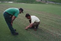
Title (German)
Risch ZG, Im M-Golfpark Holzhäusern
Caption
Greenkeeper checking the maintenance measures, partial view; Keywords Documenta Natura: golf, lowland, landfill, landscape change.
Caption (German)
Greenkeeper beim Überprüfen der Pflegemassnahmen, Teilansicht; Schlagworte Documenta Natura: Golf, Flachland, Abfalldeponie, Landschaftswandel
Record Name
Dia_303-35596

Title (German)
Risch ZG, Im M-Golfpark Holzhäusern
Caption
Head Greenkeeper Bruno Edelmann showing the ejected Corre, detail view; Keywords Documenta Natura: golf, flatland, landfill, landscape change.
Caption (German)
Head Greenkeeper Bruno Edelmann beim Zeigen der ausgeworfenen Corre, Detailansicht; Schlagworte Documenta Natura: Golf, Flachland, Abfalldeponie, Landschaftswandel
Record Name
Dia_303-35598

Title (German)
Risch ZG, Im M-Golfpark Holzhäusern
Caption
Greenkeeper maintaining the greens with various special machines, partial view; Keywords Documenta Natura: golf, lowland, waste disposal site, landscape change.
Caption (German)
Greenkeeper beim Pflegen der Greens mit verschiedenen Spezialmaschinen, Teilansicht; Schlagworte Documenta Natura: Golf, Flachland, Abfalldeponie, Landschaftswandel
Record Name
Dia_303-35600

Title (German)
Risch ZG, Im M-Golfpark Holzhäusern
Caption
Greenkeeper maintaining the greens with special machine, detail view; Keywords Documenta Natura: golf, lowland, landfill, landscape change
Caption (German)
Greenkeeper beim Pflegen der Greens mit Spezialmaschine, Detailansicht; Schlagworte Documenta Natura: Golf, Flachland, Abfalldeponie, Landschaftswandel
Record Name
Dia_303-35603
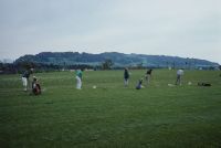
Title (German)
Risch ZG, M-Golfpark Holzhäusern, im Golfodrom
Caption
Pupils practicing tee shot, general view; Keywords Documenta Natura: golf, lowland, landfill, landscape change.
Caption (German)
Schüler beim Üben des Abschlages, Gesamtansicht; Schlagworte Documenta Natura: Golf, Flachland, Abfalldeponie, Landschaftswandel
Record Name
Dia_303-35605

Title (German)
Risch ZG, M-Golfpark Holzhäusern, im Golfodrom
Caption
Pupils practicing tee shot, general view; Keywords Documenta Natura: golf, lowland, landfill, landscape change.
Caption (German)
Schüler beim Üben des Abschlages, Gesamtansicht; Schlagworte Documenta Natura: Golf, Flachland, Abfalldeponie, Landschaftswandel
Record Name
Dia_303-35607
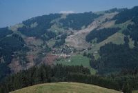
Title (German)
Plasselb FR, Westansicht des Westhanges Chleuwena mit der Rutschung und der zerstörten und geräumten Ferienhaussiedlung Falli-Hölli
Caption
West view of the western slope Chleuwena with the landslide and the destroyed vacation home settlement Falli-Hölli, in the foreground the alpine meadow Obere Tatüre, first photo (1994), reverse slope photo, general view; coordinates (LV03) of the camera location: 584575/172025; keywords Documenta Natura: landslide, Prealps, vacation home settlement
Caption (German)
Westansicht des Westhanges Chleuwena mit der Rutschung und der zerstörten Ferienhaussiedlung Falli-Hölli, im Vordergrund die Alpwiese Obere Tatüre, Erstaufnahme (1994), Gegenhangaufnahme, Gesamtansicht; Koordinaten (LV03) des Kamerastandorts: 584575/172025; Schlagworte Documenta Natura: Rutschung, Voralpen, Ferienhaussiedlung
Record Name
Dia_303-35616

Title (German)
Plasselb FR, Westansicht des Westhanges Chleuwena mit der Rutschung und der zerstörten und geräumten Ferienhaussiedlung Falli-Hölli
Caption
West view of the western slope Chleuwena with the landslide and the destroyed vacation home settlement Falli-Hölli, first photo (1994), counter slope photo, general view; coordinates (LV03) of the camera location: 584575/172025; keywords Documenta Natura: landslide, Prealps, vacation home settlement
Caption (German)
Westansicht des Westhanges Chleuwena mit der Rutschung und der zerstörten Ferienhaussiedlung Falli-Hölli, Erstaufnahme (1994), Gegenhangaufnahme, Gesamtansicht; Koordinaten (LV03) des Kamerastandorts: 584575/172025; Schlagworte Documenta Natura: Rutschung, Voralpen, Ferienhaussiedlung
Record Name
Dia_303-35626

Title (German)
Plasselb FR, Westansicht des Westhanges Chleuwena mit der Rutschung und der zerstörten und geräumten Ferienhaussiedlung Falli-Hölli
Caption
West view of the western slope Chleuwena, 1st follow-up image after the clearing of the destroyed cottage settlement (1997), counter-slope image, general view; coordinates (LV03) of the camera location: 584575/172025; keywords Documenta Natura: landslide, Pre-Alps, cottage settlement.
Caption (German)
Westansicht des Westhanges Chleuwena, 1. Folgeaufnahme nach der Räumung der zerstörten Ferienhaussiedlung (1997), Gegenhangaufnahme, Gesamtansicht; Koordinaten (LV03) des Kamerastandorts: 584575/172025; Schlagworte Documenta Natura: Rutschung, Voralpen, Ferienhaussiedlung
Record Name
Dia_303-35635

Title (German)
Plasselb FR, Südansicht des Westhanges Chleuwena mit der Rutschung und der zerstörten und geräumten Ferienhaussiedlung Falli-Hölli
Caption
South view of the western slope Chleuwena with the landslide and the destroyed vacation home settlement Falli-Hölli, first photo lower area (1994), partial view; coordinates (LV03) of the camera location: 585700/172225; keywords Documenta Natura: landslide, pre-Alps, vacation home settlement
Caption (German)
Südansicht des Westhanges Chleuwena mit der Rutschung und der zerstörten Ferienhaussiedlung Falli-Hölli, Erstaufnahme unteres Gebiet (1994), Teilansicht; Koordinaten (LV03) des Kamerastandorts: 585700/172225; Schlagworte Documenta Natura: Rutschung, Voralpen, Ferienhaussiedlung
Record Name
Dia_303-35642

Title (German)
Plasselb FR, Südansicht des Westhanges Chleuwena mit der Rutschung und der zerstörten und geräumten Ferienhaussiedlung Falli-Hölli
Caption
South view of the western slope of Chleuwena with the landslide and the destroyed vacation home settlement Falli-Hölli, first photograph of the upper area (1994), partial view; coordinates (LV03) of the camera location: 585700/172225; keywords Documenta Natura: landslide, Pre-Alps, vacation home settlement
Caption (German)
Südansicht des Westhanges Chleuwena mit der Rutschung und der zerstörten Ferienhaussiedlung Falli-Hölli, Erstaufnahme oberes Gebiet (1994), Teilansicht; Koordinaten (LV03) des Kamerastandorts: 585700/172225; Schlagworte Documenta Natura: Rutschung, Voralpen, Ferienhaussiedlung
Record Name
Dia_303-35651

Title (German)
Plasselb FR, Südansicht des Westhanges Chleuwena mit der Rutschung und der zerstörten und geräumten Ferienhaussiedlung Falli-Hölli
Caption
South view of the western slope Chleuwena with the landslide and the destroyed vacation home settlement Falli-Hölli, 1st follow-up photo lower area (1994), partial view; coordinates (LV03) of the camera location: 585700/172225; keywords Documenta Natura: landslide, Pre-Alps, vacation home settlement
Caption (German)
Südansicht des Westhanges Chleuwena mit der Rutschung und der zerstörten Ferienhaussiedlung Falli-Hölli, 1. Folgeaufnahme unteres Gebiet (1994), Teilansicht; Koordinaten (LV03) des Kamerastandorts: 585700/172225; Schlagworte Documenta Natura: Rutschung, Voralpen, Ferienhaussiedlung
Record Name
Dia_303-35661

Title (German)
Plasselb FR, Südansicht des Westhanges Chleuwena mit der Rutschung und der zerstörten und geräumten Ferienhaussiedlung Falli-Hölli
Caption
South view of the western slope Chleuwena with the landslide and the destroyed vacation home settlement Falli-Hölli, 1st follow-up photo upper area (1994), partial view; coordinates (LV03) of the camera location: 585700/172225; keywords Documenta Natura: landslide, Pre-Alps, vacation home settlement
Caption (German)
Südansicht des Westhanges Chleuwena mit der Rutschung und der zerstörten Ferienhaussiedlung Falli-Hölli, 1. Folgeaufnahme oberes Gebiet (1994), Teilansicht; Koordinaten (LV03) des Kamerastandorts: 585700/172225; Schlagworte Documenta Natura: Rutschung, Voralpen, Ferienhaussiedlung
Record Name
Dia_303-35671

Title (German)
Plasselb FR, Südansicht des Westhanges Chleuwena mit der Rutschung und der zerstörten und geräumten Ferienhaussiedlung Falli-Hölli
Caption
South view of the western slope Chleuwena with the former landslide, 2nd follow-up photograph after the clearing of the destroyed cottage settlement (1997), secondary succession, partial view; coordinates (LV03) of the camera location: 585700/172225; keywords Documenta Natura: landslide, Prealps, cottage settlement.
Caption (German)
Südansicht des Westhanges Chleuwena mit der ehemaligen Rutschung, 2. Folgeaufnahme nach der Räumung der zerstörten Ferienhaussiedlung (1997), sekundäre Sukzession, Teilansicht; Koordinaten (LV03) des Kamerastandorts: 585700/172225; Schlagworte Documenta Natura: Rutschung, Voralpen, Ferienhaussiedlung
Record Name
Dia_303-35679
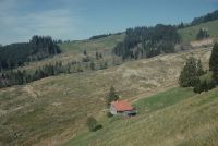
Title (German)
Plasselb FR, Südansicht des Westhanges Chleuwena mit der Rutschung und der zerstörten und geräumten Ferienhaussiedlung Falli-Hölli
Caption
South view of the western slope Chleuwena with the former landslide, 2nd follow-up photograph after the clearing of the destroyed cottage settlement (1997), secondary succession, partial view; coordinates (LV03) of the camera location: 585700/172225; keywords Documenta Natura: landslide, Prealps, cottage settlement.
Caption (German)
Südansicht des Westhanges Chleuwena mit der ehemaligen Rutschung, 2. Folgeaufnahme nach der Räumung der zerstörten Ferienhaussiedlung (1997), sekundäre Sukzession, Teilansicht; Koordinaten (LV03) des Kamerastandorts: 585700/172225; Schlagworte Documenta Natura: Rutschung, Voralpen, Ferienhaussiedlung
Record Name
Dia_303-35687

Title (German)
Plasselb FR, Westhang Chleuwena, Lantera mit der Rutschung, der zerstörten Ferienhaussiedlung Falli-Hölli und dem Höllbach
Caption
Western slope Chleuwena with the landslide and the destroyed vacation home settlement Falli-Hölli, Höllbach with the cleared forest, general view, aerial photograph; keywords Documenta Natura: landslide, Pre-Alps, vacation home settlement
Caption (German)
Westhang Chleuwena mit der Rutschung und der zerstörten Ferienhaussiedlung Falli-Hölli, Höllbach mit dem gerodeten Wald, Gesamtansicht, Luftaufnahme; Schlagworte Documenta Natura: Rutschung, Voralpen, Ferienhaussiedlung
Record Name
Dia_303-35697

Title (German)
Plasselb FR, Abgerutschte Ferienhaussiedlung Falli-Hölli südlich von Plasselb
Caption
Landslide and destroyed vacation home settlement Falli-Hölli with damaged, overturned, collapsed or in the mud sunken chalets, general view; Keywords Documenta Natura: landslide, Prealps, vacation home settlement
Caption (German)
Abgerutschte und zerstörte Ferienhaussiedlung Falli-Hölli mit beschädigten, umgekippten, eingestürzten oder im Schlamm eingesunkenen Chalets, Gesamtansicht; Schlagworte Documenta Natura: Rutschung, Voralpen, Ferienhaussiedlung
Record Name
Dia_303-35711

Title (German)
Plasselb FR, Abgerutschte Ferienhaussiedlung Falli-Hölli südlich von Plasselb
Caption
Landslide and destroyed vacation home settlement Falli-Hölli with damaged, overturned, collapsed or in the mud sunken chalets, general view; Keywords Documenta Natura: landslide, Prealps, vacation home settlement
Caption (German)
Abgerutschte und zerstörte Ferienhaussiedlung Falli-Hölli mit beschädigten, umgekippten, eingestürzten oder im Schlamm eingesunkenen Chalets, Gesamtansicht; Schlagworte Documenta Natura: Rutschung, Voralpen, Ferienhaussiedlung
Record Name
Dia_303-35715

Title (German)
Plasselb FR, Abgerutschte Ferienhaussiedlung Falli-Hölli südlich von Plasselb
Caption
Landslide and destroyed vacation home settlement Falli-Hölli with damaged, overturned, collapsed or in the mud sunken chalets, general view; Keywords Documenta Natura: landslide, Prealps, vacation home settlement
Caption (German)
Abgerutschte und zerstörte Ferienhaussiedlung Falli-Hölli mit beschädigten, umgekippten, eingestürzten oder im Schlamm eingesunkenen Chalets, Gesamtansicht; Schlagworte Documenta Natura: Rutschung, Voralpen, Ferienhaussiedlung
Record Name
Dia_303-35717

Title (German)
Plasselb FR, Abgerutschte Ferienhaussiedlung Falli-Hölli südlich von Plasselb
Caption
Landslide and destroyed vacation home settlement Falli-Hölli with damaged, overturned, collapsed or in the mud sunken chalets, partial view; Keywords Documenta Natura: landslide, Prealps, vacation home settlement
Caption (German)
Abgerutschte und zerstörte Ferienhaussiedlung Falli-Hölli mit beschädigten, umgekippten, eingestürzten oder im Schlamm eingesunkenen Chalets, Teilansicht; Schlagworte Documenta Natura: Rutschung, Voralpen, Ferienhaussiedlung
Record Name
Dia_303-35719

Title (German)
Plasselb FR, Abgerutschte Ferienhaussiedlung Falli-Hölli südlich von Plasselb
Caption
Landslide and destroyed vacation home settlement Falli-Hölli with damaged, overturned, collapsed or in the mud sunken chalets, partial view; Keywords Documenta Natura: landslide, Prealps, vacation home settlement
Caption (German)
Abgerutschte und zerstörte Ferienhaussiedlung Falli-Hölli mit beschädigten, umgekippten, eingestürzten oder im Schlamm eingesunkenen Chalets, Teilansicht; Schlagworte Documenta Natura: Rutschung, Voralpen, Ferienhaussiedlung
Record Name
Dia_303-35720

Title (German)
Plasselb FR, Abgerutschte Ferienhaussiedlung Falli-Hölli südlich von Plasselb
Caption
Landslide and destroyed vacation home settlement Falli-Hölli with damaged, overturned, collapsed or in the mud sunken chalets, partial view; Keywords Documenta Natura: landslide, Prealps, vacation home settlement
Caption (German)
Abgerutschte und zerstörte Ferienhaussiedlung Falli-Hölli mit beschädigten, umgekippten, eingestürzten oder im Schlamm eingesunkenen Chalets, Teilansicht; Schlagworte Documenta Natura: Rutschung, Voralpen, Ferienhaussiedlung
Record Name
Dia_303-35723

Title (German)
Plasselb FR, Abgerutschte Ferienhaussiedlung Falli-Hölli südlich von Plasselb
Caption
Landslide slope in the vacation home settlement Falli-Hölli with damaged chalet, partial view; keywords Documenta Natura: landslide, Pre-Alps, vacation home settlement
Caption (German)
Rutschhang in der Ferienhaussiedlung Falli-Hölli mit beschädigtem Chalet, Teilansicht; Schlagworte Documenta Natura: Rutschung, Voralpen, Ferienhaussiedlung
Record Name
Dia_303-35726

Title (German)
Plasselb FR, Abgerutschte Ferienhaussiedlung Falli-Hölli südlich von Plasselb
Caption
Landslide slope in the vacation home settlement Falli-Hölli with damaged chalet, partial view; keywords Documenta Natura: landslide, Pre-Alps, vacation home settlement
Caption (German)
Rutschhang in der Ferienhaussiedlung Falli-Hölli mit beschädigtem Chalet, Teilansicht; Schlagworte Documenta Natura: Rutschung, Voralpen, Ferienhaussiedlung
Record Name
Dia_303-35728

Title (German)
Plasselb FR, Abgerutschte Ferienhaussiedlung Falli-Hölli südlich von Plasselb
Caption
Ripped and split asphalt road, partial view; keywords Documenta Natura: landslide, foothills of the Alps, vacation home settlement
Caption (German)
Aufgerissene und gespaltene Asphaltstrasse, Teilansicht; Schlagworte Documenta Natura: Rutschung, Voralpen, Ferienhaussiedlung
Record Name
Dia_303-35730
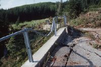
Title (German)
Plasselb FR, Abgerutschte Ferienhaussiedlung Falli-Hölli südlich von Plasselb
Caption
Ripped and split asphalt road, partial view; keywords Documenta Natura: landslide, foothills of the Alps, vacation home settlement
Caption (German)
Aufgerissene und gespaltene Asphaltstrasse, Teilansicht; Schlagworte Documenta Natura: Rutschung, Voralpen, Ferienhaussiedlung
Record Name
Dia_303-35733

Title (German)
Plasselb FR, Abgerutschte Ferienhaussiedlung Falli-Hölli südlich von Plasselb
Caption
Vacation homes destroyed by a landslide and mudslide in the Falli-Hölli, partial view; keywords Documenta Natura: landslide, Pre-Alps, vacation home settlement
Caption (German)
Durch eine Rutschung und Schlammlawine zerstörte Ferienhäuser in der Falli-Hölli, Teilansicht; Schlagworte Documenta Natura: Rutschung, Voralpen, Ferienhaussiedlung
Record Name
Dia_303-35735

Title (German)
Plasselb FR, Abgerutschte Ferienhaussiedlung Falli-Hölli südlich von Plasselb
Caption
Vacation homes destroyed by a landslide and mudslide in the Falli-Hölli, partial view; keywords Documenta Natura: landslide, Pre-Alps, vacation home settlement
Caption (German)
Durch eine Rutschung und Schlammlawine zerstörte Ferienhäuser in der Falli-Hölli, Teilansicht; Schlagworte Documenta Natura: Rutschung, Voralpen, Ferienhaussiedlung
Record Name
Dia_303-35743
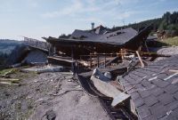
Title (German)
Plasselb FR, Abgerutschte Ferienhaussiedlung Falli-Hölli südlich von Plasselb
Caption
Vacation homes destroyed by a landslide and mudslide in the Falli-Hölli, partial view; keywords Documenta Natura: landslide, Pre-Alps, vacation home settlement
Caption (German)
Durch eine Rutschung und Schlammlawine zerstörte Ferienhäuser in der Falli-Hölli, Teilansicht; Schlagworte Documenta Natura: Rutschung, Voralpen, Ferienhaussiedlung
Record Name
Dia_303-35756

Title (German)
Plasselb FR, Abgerutschte Ferienhaussiedlung Falli-Hölli südlich von Plasselb
Caption
Vacation homes destroyed by a landslide and mudslide in the Falli-Hölli, partial view; keywords Documenta Natura: landslide, Pre-Alps, vacation home settlement
Caption (German)
Durch eine Rutschung und Schlammlawine zerstörte Ferienhäuser in der Falli-Hölli, Teilansicht; Schlagworte Documenta Natura: Rutschung, Voralpen, Ferienhaussiedlung
Record Name
Dia_303-35760

Title (German)
Plasselb FR, Abgerutschte Ferienhaussiedlung Falli-Hölli südlich von Plasselb
Caption
Vacation homes destroyed by a landslide and mudslide in the Falli-Hölli, partial view; keywords Documenta Natura: landslide, Pre-Alps, vacation home settlement
Caption (German)
Durch eine Rutschung und Schlammlawine zerstörte Ferienhäuser in der Falli-Hölli, Teilansicht; Schlagworte Documenta Natura: Rutschung, Voralpen, Ferienhaussiedlung
Record Name
Dia_303-35791

Title (German)
Plasselb FR, Abgerutschte Ferienhaussiedlung Falli-Hölli südlich von Plasselb
Caption
Vacation homes destroyed by a landslide and mudslide in the Falli-Hölli, partial view; keywords Documenta Natura: landslide, Pre-Alps, vacation home settlement
Caption (German)
Durch eine Rutschung und Schlammlawine zerstörte Ferienhäuser in der Falli-Hölli, Teilansicht; Schlagworte Documenta Natura: Rutschung, Voralpen, Ferienhaussiedlung
Record Name
Dia_303-35796

Title (German)
Plasselb FR, Abgerutschte Ferienhaussiedlung Falli-Hölli südlich von Plasselb
Caption
Vacation homes destroyed by a landslide and mudslide in the Falli-Hölli, partial view; keywords Documenta Natura: landslide, Pre-Alps, vacation home settlement
Caption (German)
Durch eine Rutschung und Schlammlawine zerstörte Ferienhäuser in der Falli-Hölli, Teilansicht; Schlagworte Documenta Natura: Rutschung, Voralpen, Ferienhaussiedlung
Record Name
Dia_303-35800

Title (German)
Plasselb FR, Abgerutschte Ferienhaussiedlung Falli-Hölli südlich von Plasselb
Caption
Vacation homes destroyed by a landslide and mudslide in the Falli-Hölli, partial view; keywords Documenta Natura: landslide, Pre-Alps, vacation home settlement
Caption (German)
Durch eine Rutschung und Schlammlawine zerstörte Ferienhäuser in der Falli-Hölli, Teilansicht; Schlagworte Documenta Natura: Rutschung, Voralpen, Ferienhaussiedlung
Record Name
Dia_303-35803

Title (German)
Plasselb FR, Abgerutschte Ferienhaussiedlung Falli-Hölli südlich von Plasselb
Caption
Vacation homes destroyed by a landslide and mudslide in the Falli-Hölli, partial view; keywords Documenta Natura: landslide, Pre-Alps, vacation home settlement
Caption (German)
Durch eine Rutschung und Schlammlawine zerstörte Ferienhäuser in der Falli-Hölli, Teilansicht; Schlagworte Documenta Natura: Rutschung, Voralpen, Ferienhaussiedlung
Record Name
Dia_303-35809

Title (German)
Plasselb FR, Abgerutschte Ferienhaussiedlung Falli-Hölli südlich von Plasselb
Caption
Landslide slope with muddy area, partial view; Keywords Documenta Natura: landslide, foothills of the Alps, vacation home settlement
Caption (German)
Rutschhang mit überschlammten Gebiet, Teilansicht; Schlagworte Documenta Natura: Rutschung, Voralpen, Ferienhaussiedlung
Record Name
Dia_303-35814

Title (German)
Plasselb FR, Abgerutschte Ferienhaussiedlung Falli-Hölli südlich von Plasselb
Caption
Forest area in landslide slope with unstable trees, partial view; keywords Documenta Natura: landslide, foothills of the Alps, vacation home settlement
Caption (German)
Waldfläche im Rutschhang mit instabilen Bäumen, Teilansicht; Schlagworte Documenta Natura: Rutschung, Voralpen, Ferienhaussiedlung
Record Name
Dia_303-35820

Title (German)
Schwanden GL, Im Wald bei Weiden nördlich von Thon
Caption
Pensioner Kaspar Blumer cutting branches, partial view; keywords Documenta Natura: windthrow, mountain forest, lumberjacking
Caption (German)
Rentner Kaspar Blumer beim Zuschneiden von Ästen, Teilansicht; Schlagworte Documenta Natura: Windwurf, Gebirgswald, Holzhauerei
Record Name
Dia_303-35831

Title (German)
Schwanden GL, Im Wald bei Weiden nördlich von Thon
Caption
Kaspar Blumer dividing the branches with the axe, partial view; Keywords Documenta Natura: windthrow, mountain forest, woodcutting
Caption (German)
Kaspar Blumer beim Teilen der Äste mit der Axt, Teilansicht; Schlagworte Documenta Natura: Windwurf, Gebirgswald, Holzhauerei
Record Name
Dia_303-35840

Title (German)
Schwanden GL, Im Wald bei Weiden nördlich von Thon
Caption
Pensioner Kaspar Blumer cutting branches, partial view; keywords Documenta Natura: windthrow, mountain forest, lumberjacking
Caption (German)
Rentner Kaspar Blumer beim Zuschneiden der Äste, Teilansicht; Schlagworte Documenta Natura: Windwurf, Gebirgswald, Holzhauerei
Record Name
Dia_303-35844
Title (German)
Schwanden GL, Im Wald bei Weiden nördlich von Thon
Caption
Kaspar Blumer bundling firewood onto the wood trestle, partial view; Keywords Documenta Natura: windthrow, mountain forest, woodcutting.
Caption (German)
Kaspar Blumer beim Bündeln von Brennholz auf den Holzbock, Teilansicht; Schlagworte Documenta Natura: Windwurf, Gebirgswald, Holzhauerei
Record Name
Dia_303-35853

Title (German)
Schwanden GL, Im Wald bei Weiden nördlich von Thon
Caption
Kaspar Blumer bundling firewood onto the wood trestle, partial view; Keywords Documenta Natura: windthrow, mountain forest, woodcutting.
Caption (German)
Kaspar Blumer beim Bündeln von Brennholz auf den Holzbock, Teilansicht; Schlagworte Documenta Natura: Windwurf, Gebirgswald, Holzhauerei
Record Name
Dia_303-35854

Title (German)
Schwanden GL, Im Wald bei Weiden nördlich von Thon
Caption
Kaspar Blumer bundling firewood onto the wood trestle, partial view; Keywords Documenta Natura: windthrow, mountain forest, woodcutting.
Caption (German)
Kaspar Blumer beim Bündeln von Brennholz auf den Holzbock, Teilansicht; Schlagworte Documenta Natura: Windwurf, Gebirgswald, Holzhauerei
Record Name
Dia_303-35857

Title (German)
Schwanden GL, Im Wald bei Weiden nördlich von Thon
Caption
Kaspar Blumer bundling firewood onto the wood trestle, partial view; Keywords Documenta Natura: windthrow, mountain forest, woodcutting.
Caption (German)
Kaspar Blumer beim Bündeln von Brennholz auf den Holzbock, Teilansicht; Schlagworte Documenta Natura: Windwurf, Gebirgswald, Holzhauerei
Record Name
Dia_303-35861

Title (German)
Schwanden GL, Im Wald bei Weiden nördlich von Thon
Caption
Kaspar Blumer bundling firewood by means of a wooden trestle with lever hoist, partial view; Keywords Documenta Natura: windthrow, mountain forest, lumberjacking
Caption (German)
Kaspar Blumer beim Bündeln von Brennholz mittels Holzbock mit Hebelzug, Teilansicht; Schlagworte Documenta Natura: Windwurf, Gebirgswald, Holzhauerei
Record Name
Dia_303-35884

Title (German)
Schwanden GL, Im Wald bei Weiden nördlich von Thon
Caption
Kaspar Blumer bundling firewood by means of a wooden trestle with a lever hoist, detail view; Keywords Documenta Natura: windthrow, mountain forest, lumberjacking
Caption (German)
Kaspar Blumer beim Bündeln von Brennholz mittels Holzbock mit Hebelzug, Detailansicht; Schlagworte Documenta Natura: Windwurf, Gebirgswald, Holzhauerei
Record Name
Dia_303-35889

Title (German)
Schwanden GL, Im Wald bei Weiden nördlich von Thon
Caption
Kaspar Blumer bundling firewood by means of a wooden trestle with lever hoist, partial view; Keywords Documenta Natura: windthrow, mountain forest, lumberjacking
Caption (German)
Kaspar Blumer beim Bündeln von Brennholz mittels Holzbock mit Hebelzug, Teilansicht; Schlagworte Documenta Natura: Windwurf, Gebirgswald, Holzhauerei
Record Name
Dia_303-35892

Title (German)
Schwanden GL, Im Wald bei Weiden nördlich von Thon
Caption
Kaspar Blumer bundling firewood by means of a wooden trestle with a lever hoist, detail view; Keywords Documenta Natura: windthrow, mountain forest, lumberjacking
Caption (German)
Kaspar Blumer beim Bündeln von Brennholz mittels Holzbock mit Hebelzug, Detailansicht; Schlagworte Documenta Natura: Windwurf, Gebirgswald, Holzhauerei
Record Name
Dia_303-35895

Title (German)
Schwanden GL, Im Wald bei Weiden nördlich von Thon
Caption
Wooden goat with lever pull, partial view; keywords Documenta Natura: windthrow, mountain forest, woodcutting
Caption (German)
Holzbock mit Hebelzug, Teilansicht; Schlagworte Documenta Natura: Windwurf, Gebirgswald, Holzhauerei
Record Name
Dia_303-35903

Title (German)
Schwanden GL, Westhang im oberen Niderental unterhalb der Schwirenwand, Westhang im Niderental unterhalb des Chrüzboden
Caption
Northwest view of the upper Niderental valley with the windthrow damage on the western slope and valley floor, first photograph taken in 1990, general view; coordinates (LV03) of camera location: 725688/203525; keywords Documenta Natura: windthrow, mountain forest, woodcutting.
Caption (German)
Nordwestansicht des oberen Niderental mit dem Windwurfflächenschaden im Westhang und Talboden, Erstaufnahme 1990, Gesamtansicht; Koordinaten (LV03) des Kamerastandorts: 725688/203525; Schlagworte Documenta Natura: Windwurf, Gebirgswald, Holzhauerei
Record Name
Dia_303-35906

Title (German)
Schwanden GL, Westhang im oberen Niderental unterhalb der Schwirenwand, Westhang im Niderental unterhalb des Chrüzboden
Caption
West view of the middle Niderental with the windthrow area in the Nüenhüttenwald, in the foreground pasture and road, first photograph 1990, counter slope photograph; coordinates (LV03) of the camera location: 725495/204450; keywords Documenta Natura: windthrow, mountain forest, woodcutting.
Caption (German)
Westansicht des mittleren Niderental mit dem Windwurfflächenschaden im Nüenhüttenwald, im Vordergrund Weide und Strasse, Erstaufnahme 1990, Gegenhangaufnahme; Koordinaten (LV03) des Kamerastandorts: 725495/204450; Schlagworte Documenta Natura: Windwurf, Gebirgswald, Holzhauerei
Record Name
Dia_303-35930

Title (German)
Schwanden GL, Westhang im oberen Niderental unterhalb der Schwirenwand, Westhang im Niderental unterhalb des Chrüzboden
Caption
Northwest view of the upper Niderental valley with the windthrow damage on the western slope and valley floor, 1st follow-up photograph 1992, general view; coordinates (LV03) of the camera location: 725688/203525; keywords Documenta Natura: windthrow, mountain forest, woodcutting.
Caption (German)
Nordwestansicht des oberen Niderental mit dem Windwurfflächenschaden im Westhang und Talboden, 1. Folgeaufnahme 1992, Gesamtansicht; Koordinaten (LV03) des Kamerastandorts: 725688/203525; Schlagworte Documenta Natura: Windwurf, Gebirgswald, Holzhauerei
Record Name
Dia_303-35935

Title (German)
Schwanden GL, Westhang im oberen Niderental unterhalb der Schwirenwand, Westhang im Niderental unterhalb des Chrüzboden
Caption
West view of the middle Niderental with the windthrow area in the Nüenhüttenwald, in the foreground pasture and road, 1st follow-up photo 1992, counter slope photo; coordinates (LV03) of the camera location: 725495/204450; keywords Documenta Natura: windthrow, mountain forest, woodcutting.
Caption (German)
Westansicht des mittleren Niderental mit dem Windwurfflächenschaden im Nüenhüttenwald, im Vordergrund Weide und Strasse, 1. Folgeaufnahme 1992, Gegenhangaufnahme; Koordinaten (LV03) des Kamerastandorts: 725495/204450; Schlagworte Documenta Natura: Windwurf, Gebirgswald, Holzhauerei
Record Name
Dia_303-35950

Title (German)
Schwanden GL, Südwestansicht des Gandberg
Caption
Southwest view of Gandberg with the windthrow area, storm wood not scaffolded, first photograph 1990, counter slope photograph, general view; coordinates (LV03) of camera location: 724895/203625; keywords Documenta Natura: windthrow, mountain forest, woodcutting.
Caption (German)
Südwestansicht des Gandberg mit der Windwurffläche, Sturmholz nicht gerüstet, Erstaufnahme 1990, Gegenhangaufnahme, Gesamtansicht; Koordinaten (LV03) des Kamerastandorts: 724895/203625; Schlagworte Documenta Natura: Windwurf, Gebirgswald, Holzhauerei
Record Name
Dia_303-35963

Title (German)
Schwanden GL, Südwestansicht des Gandberg
Caption
Southwest view of Gandberg with the windthrow area, storm wood not scaffolded, 1st follow-up photograph 1995, counter slope photograph, general view; coordinates (LV03) of camera location: 724895/203625; keywords Documenta Natura: windthrow, mountain forest, woodcutting.
Caption (German)
Südwestansicht des Gandberg mit der Windwurffläche, Sturmholz nicht gerüstet, 1. Folgeaufnahme 1995, Gegenhangaufnahme, Gesamtansicht; Koordinaten (LV03) des Kamerastandorts: 724895/203625; Schlagworte Documenta Natura: Windwurf, Gebirgswald, Holzhauerei
Record Name
Dia_303-35973

Title (German)
Schwanden GL, Nordwestansicht des Gandberg, im Vordergrund das Dorf Schwanden (z. T.)
Caption
Northwest view of the Gandberg with the windthrow area, storm wood not scaffolded, in the foreground the village of Schwanden, first photograph (1990), general view; coordinates (LV03) of the camera location: 724000/206465; keywords Documenta Natura: windthrow, mountain forest, lumberjacking
Caption (German)
Nordwestansicht des Gandberg mit der Windwurffläche, Sturmholz nicht gerüstet, im Vordergrund das Dorf Schwanden, Erstaufnahme (1990), Gesamtansicht; Koordinaten (LV03) des Kamerastandorts: 724000/206465; Schlagworte Documenta Natura: Windwurf, Gebirgswald, Holzhauerei
Record Name
Dia_303-35984

Title (German)
Schwanden GL, Nordwestansicht des Gandberg, im Vordergrund das Dorf Schwanden (z. T.)
Caption
Northwest view of the Gandberg with the former windthrow area, storm wood scaffolded, in the foreground the village of Schwanden, 1st subsequent photograph (1995), general view; coordinates (LV03) of the camera location: 724000/206465; keywords Documenta Natura: windthrow, mountain forest, lumbering
Caption (German)
Nordwestansicht des Gandberg mit der ehemaligen Windwurffläche, Sturmholz gerüstet, im Vordergrund das Dorf Schwanden, 1. Folgeaufnahme (1995), Gesamtansicht; Koordinaten (LV03) des Kamerastandorts: 724000/206465; Schlagworte Documenta Natura: Windwurf, Gebirgswald, Holzhauerei
Record Name
Dia_303-35990

Title (German)
Innertkirchen BE, Nordwestansicht des Nordwesthanges im vorderen Urbachtal mit dem Vordertalwald, Understockwald und Hohstaldenwald, z. T. mit dem Loibstock
Caption
Northwest view of the northwest slope in the front Urbach valley with the windthrow areas in the Vordertalwald, Understockwald and Hohstaldenwald, storm wood scaffolded, counter-slope view, partial view; coordinates (LV03) of the camera location: 659610/171280; keywords Documenta Natura: windthrow, wood storage
Caption (German)
Nordwestansicht des Nordwesthanges im vorderen Urbachtal mit den Windwurfflächen im Vordertalwald, Understockwald und Hohstaldenwald, Sturmholz gerüstet, Gegenhangaufnahme, Teilansicht; Koordinaten (LV03) des Kamerastandorts: 659610/171280; Schlagworte Documenta Natura: Windwurf, Holzlagerung
Record Name
Dia_303-36001

Title (German)
Guttannen BE, Südansicht von Guttannen mit Südsüdwesthang, Graustock und Mährenhorn
Caption
South view of Guttannen with the south-southwest slope, Graustock and Mährenhorn, partly with the Bänzlauistock, reconstruction photo (1991), counter-slope photo, general view; coordinates (LV03) of the camera location: 664935/166780; keywords Documenta Natura: windthrow, wood storage
Caption (German)
Südansicht von Guttannen mit dem Südsüdwesthang, Graustock und Mährenhorn, teilweise mit dem Bänzlauistock, Rekonstruktionsaufnahme (1991), Gegenhangaufnahme, Gesamtansicht; Koordinaten (LV03) des Kamerastandorts: 664935/166780; Schlagworte Documenta Natura: Windwurf, Holzlagerung
Record Name
Dia_303-36014

Title (German)
Guttannen BE, Südansicht von Guttannen mit Südsüdwesthang, Graustock und Mährenhorn
Caption
South view of Guttannen with the south-southwest slope, Graustock and Mährenhorn, partly with the Bänzlauistock, reconstruction photo (1991), counter-slope photo, general view; coordinates (LV03) of the camera location: 664935/166780; keywords Documenta Natura: windthrow, wood storage
Caption (German)
Südansicht von Guttannen mit dem Südsüdwesthang, Graustock und Mährenhorn, teilweise mit dem Bänzlauistock, Rekonstruktionsaufnahme (1991), Gegenhangaufnahme, Gesamtansicht; Koordinaten (LV03) des Kamerastandorts: 664935/166780; Schlagworte Documenta Natura: Windwurf, Holzlagerung
Record Name
Dia_303-36024

Title (German)
Brienz BE, Westhang Brand im Giessbachtal
Caption
West slope fire with the windthrow damage, in the foreground wet storage areas with the cleared storm wood, partial view; coordinates (LV03) of the camera location: 644745/174010; keywords Documenta Natura: windthrow, wood storage.
Caption (German)
Westhang Brand mit den Windwurfflächenschaden, im Vordergrund Nasslagerplätze mit dem aufgeräumten Sturmholz, Teilansicht; Koordinaten (LV03) des Kamerastandorts: 644745/174010; Schlagworte Documenta Natura: Windwurf, Holzlagerung
Record Name
Dia_303-36034

Title (German)
Brienz BE, Westhang Brand im Giessbachtal
Caption
West slope fire with the cleared windthrow area, partial view; coordinates (LV03) of the camera location: 644745/174010; keywords Documenta Natura: windthrow, wood storage.
Caption (German)
Westhang Brand mit der geräumten Windwurffläche, Teilansicht; Koordinaten (LV03) des Kamerastandorts: 644745/174010; Schlagworte Documenta Natura: Windwurf, Holzlagerung
Record Name
Dia_303-36038

Title (German)
Brienz BE, Westhang Brand im Giessbachtal
Caption
West slope fire with the cleared windthrow area, partial view; coordinates (LV03) of the camera location: 644805/173913; keywords Documenta Natura: windthrow, wood storage.
Caption (German)
Westhang Brand mit der geräumten Windwurffläche, Teilansicht; Koordinaten (LV03) des Kamerastandorts: 644805/173913; Schlagworte Documenta Natura: Windwurf, Holzlagerung
Record Name
Dia_303-36044

Title (German)
Brienz BE, Westhang Brand im Giessbachtal
Caption
West slope fire with the windthrow damage, in the foreground wet storage areas with the cleared storm wood, partial view; coordinates (LV03) of the camera location: 644940/174510; keywords Documenta Natura: windthrow, wood storage.
Caption (German)
Westhang Brand mit den Windwurfflächenschaden, im Vordergrund Nasslagerplätze mit dem aufgeräumten Sturmholz, Teilansicht; Koordinaten (LV03) des Kamerastandorts: 644940/174510; Schlagworte Documenta Natura: Windwurf, Holzlagerung
Record Name
Dia_303-36056

Guttannen BE, southwest view of the southern slope Raafgartisegg with Steinhüshorn and Chilchlistock
Title (German)
Guttannen BE, Südwestansicht des Südhanges Raafgartisegg mit Steinhüshorn und Chilchlistock
Caption
Southwest view of the windthrow area in the southern slope Raafgartisegg, storm wood partly scaffolded, in the background Steinhüshorn and Chilchlistock, general view; coordinates (LV03) of the camera location: 664775/168305; keywords Documenta Natura: windthrow, wood storage
Caption (German)
Südwestansicht des Windwurfflächenschadens im Südhang Raafgartisegg, Sturmholz teilweise gerüstet, im Hintergrund Steinhüshorn und Chilchlistock, Gesamtansicht; Koordinaten (LV03) des Kamerastandorts: 664775/168305; Schlagworte Documenta Natura: Windwurf, Holzlagerung
Record Name
Dia_303-36063
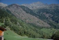
Guttannen BE, southwest view of the southern slope Raafgartisegg with Steinhüshorn and Chilchlistock
Title (German)
Guttannen BE, Südwestansicht des Südhanges Raafgartisegg mit Steinhüshorn und Chilchlistock
Caption
Southwest view of the windthrow area in the southern slope Raafgartisegg, storm wood partly scaffolded, in the background Steinhüshorn and Chilchlistock, general view; coordinates (LV03) of the camera location: 664775/168305; keywords Documenta Natura: windthrow, wood storage
Caption (German)
Südwestansicht des Windwurfflächenschadens im Südhang Raafgartisegg, Sturmholz teilweise gerüstet, im Hintergrund Steinhüshorn und Chilchlistock, Gesamtansicht; Koordinaten (LV03) des Kamerastandorts: 664775/168305; Schlagworte Documenta Natura: Windwurf, Holzlagerung
Record Name
Dia_303-36072

Title (German)
Guttannen BE, Südwesthang mit Schlagwald oberhalb Boden
Caption
Southwest view of windthrow litter damage in southwest slope above ground, storm wood not scaffolded, image taken during vegetation phase, counter slope image; coordinates (LV03) of camera location: 662910/169110; keywords Documenta Natura: windthrow, wood storage.
Caption (German)
Südwestansicht des Windwurfstreuschadens im Südwesthang oberhalb Boden, Sturmholz nicht gerüstet, Aufnahme während der Vegetationsphase, Gegenhangaufnahme; Koordinaten (LV03) des Kamerastandorts: 662910/169110; Schlagworte Documenta Natura: Windwurf, Holzlagerung
Record Name
Dia_303-36081

Title (German)
Brienz BE, Im Giessbachtal, Giessbächen
Caption
Wood storage area with several pile piles along the road and the Giessbach stream, in the background the windthrow areas, wet storage (sprinkling not visible on the picture), partial view; keywords Documenta Natura: windthrow, wood storage
Caption (German)
Holzlagerplatz mit mehreren Haufenpoltern entlang der Strasse und des Giessbaches, im Hintergrund die Windwurfflächen, Nasslagerung (Berieselung auf dem Bild nicht erkennbar), Teilansicht; Schlagworte Documenta Natura: Windwurf, Holzlagerung
Record Name
Dia_303-36088

Title (German)
Guttannen BE, Am Fusse der Rotlaui zwischen Kantonsstrasse und Aare
Caption
Wood storage yard with pile pile sprinkled by high hung hoses, wet storage, general view; keywords Documenta Natura: windthrow, wood storage.
Caption (German)
Holzlagerplatz mit durch hochgehängten Schläuchen berieseltem Haufenpolter, Nasslagerung, Gesamtansicht; Schlagworte Documenta Natura: Windwurf, Holzlagerung
Record Name
Dia_303-36093

Title (German)
Guttannen BE, Am Fusse der Rotlaui zwischen Kantonsstrasse und Aare
Caption
Wood storage yard with pile pile sprinkled by high hung hoses, wet storage, partial view; Keywords Documenta Natura: windthrow, wood storage.
Caption (German)
Holzlagerplatz mit durch hochgehängten Schläuchen berieseltem Haufenpolter, Nasslagerung, Teilansicht; Schlagworte Documenta Natura: Windwurf, Holzlagerung
Record Name
Dia_303-36096

Title (German)
Meiringen BE, Wald oberhalb Isetwald westlich von Falcheren
Caption
View upslope over the windthrow area with broken and fallen spruce trees, partial view; Keywords Documenta Natura: windthrow, wood storage.
Caption (German)
Blick hangaufwärts über den Windwurfflächenschaden mit umgebrochenen und umgeworfenen Fichten, Teilansicht; Schlagworte Documenta Natura: Windwurf, Holzlagerung
Record Name
Dia_303-36098

Title (German)
Meiringen BE, Wald oberhalb Isetwald westlich von Falcheren
Caption
View upslope over the windthrow area with broken and fallen spruce trees, partial view; Keywords Documenta Natura: windthrow, wood storage.
Caption (German)
Blick hangaufwärts über den Windwurfflächenschaden mit umgebrochenen und umgeworfenen Fichten, Teilansicht; Schlagworte Documenta Natura: Windwurf, Holzlagerung
Record Name
Dia_303-36102

Title (German)
Meiringen BE, Wald oberhalb Isetwald westlich von Falcheren
Caption
Windthrow damage with broken and fallen spruces, truck with crane loading storm wood, partial view; keywords Documenta Natura: windthrow, wood storage.
Caption (German)
Windwurfflächenschaden mit umgebrochenen und umgeworfenen Fichten, Lastwagen mit Kran beim Verladen von Sturmholz, Teilansicht; Schlagworte Documenta Natura: Windwurf, Holzlagerung
Record Name
Dia_303-36105

Title (German)
Münchenbuchsee BE, Südansicht des Hübeli Quartiers
Caption
South view of the Hübeli quarter, in the foreground the apartment block Paul-Klee Strasse 103, reconstruction shot, partial view; coordinates (LV03) of the camera location: 600010/207730; keywords Documenta Natura: landscape change, agriculture_general, village, lowlands
Caption (German)
Südansicht des Hübeli Quartiers, im Vordergrund der Wohnblock Paul-Klee Strasse 103, Rekonstruktionsaufnahme, Teilansicht; Koordinaten (LV03) des Kamerastandorts: 600010/207730; Schlagworte Documenta Natura: Landschaftswandel, Landwirtschaft_Allgemein, Dorf, Flachland
Record Name
Dia_303-36110

Title (German)
Münchenbuchsee BE, Nordwestansicht des Riedli Quartiers
Caption
Northwest view of the Riedli quarter, in the foreground shrubs and trees, reconstruction shot, partial view; coordinates (LV03) of the camera location: 599810/208220; keywords Documenta Natura: landscape_change, agriculture_general, village, lowlands
Caption (German)
Nordwestansicht des Riedli Quartiers, im Vordergrund Sträucher und Bäume, Rekonstruktionsaufnahme, Teilansicht; Koordinaten (LV03) des Kamerastandorts: 599810/208220; Schlagworte Documenta Natura: Landschaftswandel, Landwirtschaft_Allgemein, Dorf, Flachland
Record Name
Dia_303-36116

Title (German)
Flühli LU, Auf Salwiden, Hochmoorföhrenwald südöstlich des Weilers Turnschwand
Caption
Semi-open raised bog Türnliwald (habitat type Sphagnion magellanici) with transition to raised bog mountain pine forest (habitat type Ledo-Pinion), photograph taken in the UNESCO Entlebuch Biosphere Reserve at the end of the vegetation phase, partial view; keywords Documenta Natura: wetland.
Caption (German)
Halboffenes Hochmoor Türnliwald (Lebensraumtyp Sphagnion magellanici) mit Übergang zu Hochmoor-Bergföhrenwald (Lebensraumtyp Ledo-Pinion), Aufnahme im UNESCO-Biosphärenreservat Entlebuch bei Ende der Vegetationsphase, Teilansicht; Schlagworte Documenta Natura: Feuchtgebiet
Record Name
Dia_303-36126

Title (German)
Flühli LU, Auf Salwiden, Hochmoorföhrenwald südöstlich des Weilers Turnschwand
Caption
Semi-open raised bog Türnliwald (habitat type Sphagnion magellanici) with transition to raised bog mountain pine forest (habitat type Ledo-Pinion), photograph taken in the UNESCO Entlebuch Biosphere Reserve at the end of the vegetation phase, partial view; keywords Documenta Natura: wetland.
Caption (German)
Halboffenes Hochmoor Türnliwald (Lebensraumtyp Sphagnion magellanici) mit Übergang zu Hochmoor-Bergföhrenwald (Lebensraumtyp Ledo-Pinion), Aufnahme im UNESCO-Biosphärenreservat Entlebuch bei Ende der Vegetationsphase, Teilansicht; Schlagworte Documenta Natura: Feuchtgebiet
Record Name
Dia_303-36131

Title (German)
Flühli LU, Auf Salwiden, Hochmoorföhrenwald südöstlich des Weilers Turnschwand
Caption
Semi-open raised bog Türnliwald (habitat type Sphagnion magellanici) with transition to raised bog mountain pine forest (habitat type Ledo-Pinion), photograph taken in the UNESCO Entlebuch Biosphere Reserve at the end of the vegetation phase, partial view; keywords Documenta Natura: wetland.
Caption (German)
Halboffenes Hochmoor Türnliwald (Lebensraumtyp Sphagnion magellanici) mit Übergang zu Hochmoor-Bergföhrenwald (Lebensraumtyp Ledo-Pinion), Aufnahme im UNESCO-Biosphärenreservat Entlebuch bei Ende der Vegetationsphase, Teilansicht; Schlagworte Documenta Natura: Feuchtgebiet
Record Name
Dia_303-36136

Title (German)
Flühli LU, Auf Salwiden, Hochmoorföhrenwald südöstlich des Weilers Turnschwand
Caption
Semi-open raised bog Türnliwald (habitat type Sphagnion magellanici) with transition to raised bog mountain pine forest (habitat type Ledo-Pinion), photograph taken in the UNESCO Entlebuch Biosphere Reserve at the end of the vegetation phase, partial view; keywords Documenta Natura: wetland.
Caption (German)
Halboffenes Hochmoor Türnliwald (Lebensraumtyp Sphagnion magellanici) mit Übergang zu Hochmoor-Bergföhrenwald (Lebensraumtyp Ledo-Pinion), Aufnahme im UNESCO-Biosphärenreservat Entlebuch bei Ende der Vegetationsphase, Teilansicht; Schlagworte Documenta Natura: Feuchtgebiet
Record Name
Dia_303-36141

Title (German)
Flühli LU, Auf Salwiden, Hochmoorföhrenwald südöstlich des Weilers Turnschwand
Caption
Semi-open raised bog Türnliwald (habitat type Sphagnion magellanici) with transition to raised bog mountain pine forest (habitat type Ledo-Pinion), photograph taken in the UNESCO Entlebuch Biosphere Reserve at the end of the vegetation phase, partial view; keywords Documenta Natura: wetland.
Caption (German)
Halboffenes Hochmoor Türnliwald (Lebensraumtyp Sphagnion magellanici) mit Übergang zu Hochmoor-Bergföhrenwald (Lebensraumtyp Ledo-Pinion), Aufnahme im UNESCO-Biosphärenreservat Entlebuch bei Ende der Vegetationsphase, Teilansicht; Schlagworte Documenta Natura: Feuchtgebiet
Record Name
Dia_303-36151

Title (German)
Flühli LU, Auf Salwiden, Hochmoorföhrenwald südöstlich des Weilers Turnschwand
Caption
Semi-open raised bog Türnliwald (habitat type Sphagnion magellanici) with transition to raised bog mountain pine forest (habitat type Ledo-Pinion), photograph taken in the UNESCO Entlebuch Biosphere Reserve at the end of the vegetation phase, partial view; keywords Documenta Natura: wetland.
Caption (German)
Halboffenes Hochmoor Türnliwald (Lebensraumtyp Sphagnion magellanici) mit Übergang zu Hochmoor-Bergföhrenwald (Lebensraumtyp Ledo-Pinion), Aufnahme im UNESCO-Biosphärenreservat Entlebuch bei Ende der Vegetationsphase, Teilansicht; Schlagworte Documenta Natura: Feuchtgebiet
Record Name
Dia_303-36157

Title (German)
Flühli LU, Auf Salwiden, Hochmoorföhrenwald südöstlich des Weilers Turnschwand
Caption
Mountain pines on hump-like bulbs (elevations) in the semi-open Türnliwald raised bog (habitat type Sphagnion magellanici) with transition to raised bog mountain pine forest (habitat type Ledo-Pinion), photograph taken in the Entlebuch UNESCO Biosphere Reserve at the end of the vegetation phase, partial view; keywords Documenta Natura: wetland.
Caption (German)
Bergföhren auf höckerartigen Bulten (Erhöhungen) im halboffenen Hochmoor Türnliwald (Lebensraumtyp Sphagnion magellanici) mit Übergang zu Hochmoor-Bergföhrenwald (Lebensraumtyp Ledo-Pinion), Aufnahme im UNESCO-Biosphärenreservat Entlebuch bei Ende der Vegetationsphase, Teilansicht; Schlagworte Documenta Natura: Feuchtgebiet
Record Name
Dia_303-36161

Title (German)
Flühli LU, Auf Salwiden, Hochmoorföhrenwald südöstlich des Weilers Turnschwand
Caption
Ground vegetation of ericaceous dwarf shrubs, moss and grasses in the Türnliwald semi-open raised bog (habitat type Sphagnion magellanici), photograph taken in the Entlebuch UNESCO Biosphere Reserve at the end of the vegetation phase, close-up; keywords Documenta Natura: wetland.
Caption (German)
Bodenvegetation aus Erika-Zwergsträuchern, Moos und Gräser im halboffenen Hochmoor Türnliwald (Lebensraumtyp Sphagnion magellanici), Aufnahme im UNESCO-Biosphärenreservat Entlebuch bei Ende der Vegetationsphase, Detailansicht; Schlagworte Documenta Natura: Feuchtgebiet
Record Name
Dia_303-36166

Title (German)
Flühli LU, Auf Salwiden, Hochmoorföhrenwald südöstlich des Weilers Turnschwand
Caption
Ground vegetation of ericaceous dwarf shrubs, moss and grasses in the Türnliwald semi-open raised bog (habitat type Sphagnion magellanici), photograph taken in the Entlebuch UNESCO Biosphere Reserve at the end of the vegetation phase, close-up; keywords Documenta Natura: wetland.
Caption (German)
Bodenvegetation aus Erika-Zwergsträuchern, Moos und Gräser im halboffenen Hochmoor Türnliwald (Lebensraumtyp Sphagnion magellanici), Aufnahme im UNESCO-Biosphärenreservat Entlebuch bei Ende der Vegetationsphase, Detailansicht; Schlagworte Documenta Natura: Feuchtgebiet
Record Name
Dia_303-36171

Title (German)
Flühli LU, Auf Salwiden, Hochmoorföhrenwald südöstlich des Weilers Turnschwand
Caption
Ground vegetation of ericaceous dwarf shrubs, moss and grasses in the Türnliwald semi-open raised bog (habitat type Sphagnion magellanici), open waterhole (bog eye), photograph taken in the Entlebuch UNESCO Biosphere Reserve at the end of the vegetation phase, close-up; keywords Documenta Natura: wetland
Caption (German)
Bodenvegetation aus Erika-Zwergsträuchern, Moos und Gräser im halboffenen Hochmoor Türnliwald (Lebensraumtyp Sphagnion magellanici), offene Wasserstelle (Moorauge), Aufnahme im UNESCO-Biosphärenreservat Entlebuch bei Ende der Vegetationsphase, Detailansicht; Schlagworte Documenta Natura: Feuchtgebiet
Record Name
Dia_303-36176

Title (German)
Flühli LU, Auf Salwiden, Hochmoorföhrenwald südöstlich des Weilers Turnschwand
Caption
Bog eye (open waterhole) in the Türnliwald raised bog (habitat type Sphagnion magellanici), photograph taken in the Entlebuch UNESCO Biosphere Reserve at the end of the vegetation phase, close-up; keywords Documenta Natura: wetland
Caption (German)
Moorauge (offene Wasserstelle) im Hochmoor Türnliwald (Lebensraumtyp Sphagnion magellanici), Aufnahme im UNESCO-Biosphärenreservat Entlebuch bei Ende der Vegetationsphase, Detailansicht; Schlagworte Documenta Natura: Feuchtgebiet
Record Name
Dia_303-36185

Title (German)
Flühli LU, Auf Salwiden, Hochmoorföhrenwald südöstlich des Weilers Turnschwand
Caption
Bog eye (open waterhole) in the Türnliwald raised bog (habitat type Sphagnion magellanici), photograph taken in the Entlebuch UNESCO Biosphere Reserve at the end of the vegetation phase, close-up; keywords Documenta Natura: wetland
Caption (German)
Moorauge (offene Wasserstelle) im Hochmoor Türnliwald (Lebensraumtyp Sphagnion magellanici), Aufnahme im UNESCO-Biosphärenreservat Entlebuch bei Ende der Vegetationsphase, Detailansicht; Schlagworte Documenta Natura: Feuchtgebiet
Record Name
Dia_303-36196

Title (German)
Flühli LU, Auf Salwiden, Hochmoorföhrenwald südöstlich des Weilers Turnschwand
Caption
Bog eye (open waterhole) in the Türnliwald raised bog (habitat type Sphagnion magellanici), photograph taken in the Entlebuch UNESCO Biosphere Reserve at the end of the vegetation phase, close-up; keywords Documenta Natura: wetland
Caption (German)
Moorauge (offene Wasserstelle) im Hochmoor Türnliwald (Lebensraumtyp Sphagnion magellanici), Aufnahme im UNESCO-Biosphärenreservat Entlebuch bei Ende der Vegetationsphase, Detailansicht; Schlagworte Documenta Natura: Feuchtgebiet
Record Name
Dia_303-36201

Title (German)
Flühli LU, Auf Salwiden, Hochmoorföhrenwald südöstlich des Weilers Turnschwand
Caption
Ground vegetation of ericaceous dwarf shrubs, moss and grasses in the Türnliwald semi-open raised bog (habitat type Sphagnion magellanici), photograph taken in the Entlebuch UNESCO Biosphere Reserve at the end of the vegetation phase, close-up; keywords Documenta Natura: wetland.
Caption (German)
Bodenvegetation aus Erika-Zwergsträuchern, Moos und Gräser im halboffenen Hochmoor Türnliwald (Lebensraumtyp Sphagnion magellanici), Aufnahme im UNESCO-Biosphärenreservat Entlebuch bei Ende der Vegetationsphase, Detailansicht; Schlagworte Documenta Natura: Feuchtgebiet
Record Name
Dia_303-36206

Title (German)
Flühli LU, Auf Salwiden, Hochmoorföhrenwald südöstlich des Weilers Turnschwand
Caption
Ground vegetation of ericaceous dwarf shrubs, moss and grasses in the Türnliwald semi-open raised bog (habitat type Sphagnion magellanici), photograph taken in the Entlebuch UNESCO Biosphere Reserve at the end of the vegetation phase, close-up; keywords Documenta Natura: wetland.
Caption (German)
Bodenvegetation aus Erika-Zwergsträuchern, Moos und Gräser im halboffenen Hochmoor Türnliwald (Lebensraumtyp Sphagnion magellanici), Aufnahme im UNESCO-Biosphärenreservat Entlebuch bei Ende der Vegetationsphase, Detailansicht; Schlagworte Documenta Natura: Feuchtgebiet
Record Name
Dia_303-36211

Title (German)
Flühli LU, Auf Salwiden, Hochmoorföhrenwald südöstlich des Weilers Turnschwand
Caption
Ground vegetation of ericaceous dwarf shrubs, moss and grasses in the Türnliwald semi-open raised bog (habitat type Sphagnion magellanici), photograph taken in the Entlebuch UNESCO Biosphere Reserve at the end of the vegetation phase, close-up; keywords Documenta Natura: wetland.
Caption (German)
Bodenvegetation aus Erika-Zwergsträuchern, Moos und Gräser im halboffenen Hochmoor Türnliwald (Lebensraumtyp Sphagnion magellanici), Aufnahme im UNESCO-Biosphärenreservat Entlebuch bei Ende der Vegetationsphase, Detailansicht; Schlagworte Documenta Natura: Feuchtgebiet
Record Name
Dia_303-36216

Title (German)
Flühli LU, Auf Salwiden, Hochmoorföhrenwald südöstlich des Weilers Turnschwand
Caption
Ground vegetation of ericaceous dwarf shrubs, moss and grasses in the Türnliwald semi-open raised bog (habitat type Sphagnion magellanici), open waterhole (bog eye), photograph taken in the Entlebuch UNESCO Biosphere Reserve at the end of the vegetation phase, close-up; keywords Documenta Natura: wetland
Caption (German)
Bodenvegetation aus Erika-Zwergsträuchern, Moos und Gräser im halboffenen Hochmoor Türnliwald (Lebensraumtyp Sphagnion magellanici), offene Wasserstelle (Moorauge), Aufnahme im UNESCO-Biosphärenreservat Entlebuch bei Ende der Vegetationsphase, Detailansicht; Schlagworte Documenta Natura: Feuchtgebiet
Record Name
Dia_303-36221

Title (German)
Flühli LU, Auf Salwiden, Hochmoorföhrenwald südöstlich des Weilers Turnschwand
Caption
Ground vegetation of ericaceous dwarf shrubs, moss and grasses in the Türnliwald semi-open raised bog (habitat type Sphagnion magellanici), photograph taken in the Entlebuch UNESCO Biosphere Reserve at the end of the vegetation phase, close-up; keywords Documenta Natura: wetland.
Caption (German)
Bodenvegetation aus Erika-Zwergsträuchern, Moos und Gräser im halboffenen Hochmoor Türnliwald (Lebensraumtyp Sphagnion magellanici), Aufnahme im UNESCO-Biosphärenreservat Entlebuch bei Ende der Vegetationsphase, Detailansicht; Schlagworte Documenta Natura: Feuchtgebiet
Record Name
Dia_303-36226

Title (German)
Flühli LU, Auf Salwiden, Hochmoorföhrenwald südöstlich des Weilers Turnschwand
Caption
Ground vegetation of ericaceous dwarf shrubs, moss and grasses in the Türnliwald semi-open raised bog (habitat type Sphagnion magellanici), photograph taken in the Entlebuch UNESCO Biosphere Reserve at the end of the vegetation phase, close-up; keywords Documenta Natura: wetland.
Caption (German)
Bodenvegetation aus Erika-Zwergsträuchern, Moos und Gräser im halboffenen Hochmoor Türnliwald (Lebensraumtyp Sphagnion magellanici), Aufnahme im UNESCO-Biosphärenreservat Entlebuch bei Ende der Vegetationsphase, Detailansicht; Schlagworte Documenta Natura: Feuchtgebiet
Record Name
Dia_303-36241

Title (German)
Flühli LU, Auf Salwiden, Hochmoorföhrenwald südöstlich des Weilers Turnschwand
Caption
Bog eye (open waterhole) in the semi-open raised bog Türnliwald (habitat type Sphagnion magellanici), photograph taken in the UNESCO Entlebuch Biosphere Reserve at the end of the vegetation phase, close-up; keywords Documenta Natura: wetland
Caption (German)
Moorauge (offene Wasserstelle) im halboffenen Hochmoor Türnliwald (Lebensraumtyp Sphagnion magellanici), Aufnahme im UNESCO-Biosphärenreservat Entlebuch bei Ende der Vegetationsphase, Detailansicht; Schlagworte Documenta Natura: Feuchtgebiet
Record Name
Dia_303-36246

Title (German)
Flühli LU, Auf Salwiden, Hochmoorföhrenwald südöstlich des Weilers Turnschwand
Caption
Ground vegetation of ericaceous dwarf shrubs, moss and grasses in the Türnliwald semi-open raised bog (habitat type Sphagnion magellanici), photograph taken in the Entlebuch UNESCO Biosphere Reserve at the end of the vegetation phase, close-up; keywords Documenta Natura: wetland.
Caption (German)
Bodenvegetation aus Erika-Zwergsträuchern, Moos und Gräser im halboffenen Hochmoor Türnliwald (Lebensraumtyp Sphagnion magellanici), Aufnahme im UNESCO-Biosphärenreservat Entlebuch bei Ende der Vegetationsphase, Detailansicht; Schlagworte Documenta Natura: Feuchtgebiet
Record Name
Dia_303-36251

Title (German)
Flühli LU, Auf Salwiden, Hochmoorföhrenwald südöstlich des Weilers Turnschwand
Caption
Bog eye (open waterhole) in the semi-open raised bog Türnliwald (habitat type Sphagnion magellanici), photograph taken in the UNESCO Entlebuch Biosphere Reserve at the end of the vegetation phase, close-up; keywords Documenta Natura: wetland
Caption (German)
Moorauge (offene Wasserstelle) im halboffenen Hochmoor Türnliwald (Lebensraumtyp Sphagnion magellanici), Aufnahme im UNESCO-Biosphärenreservat Entlebuch bei Ende der Vegetationsphase, Detailansicht; Schlagworte Documenta Natura: Feuchtgebiet
Record Name
Dia_303-36256

Title (German)
Flühli LU, Auf Salwiden, Hochmoorföhrenwald südöstlich des Weilers Turnschwand
Caption
Ground vegetation of ericaceous dwarf shrubs, moss and grasses in the Türnliwald semi-open raised bog (habitat type Sphagnion magellanici), photograph taken in the Entlebuch UNESCO Biosphere Reserve at the end of the vegetation phase, close-up; keywords Documenta Natura: wetland.
Caption (German)
Bodenvegetation aus Erika-Zwergsträuchern, Moos und Gräser im halboffenen Hochmoor Türnliwald (Lebensraumtyp Sphagnion magellanici), Aufnahme im UNESCO-Biosphärenreservat Entlebuch bei Ende der Vegetationsphase, Detailansicht; Schlagworte Documenta Natura: Feuchtgebiet
Record Name
Dia_303-36261

Title (German)
Flühli LU, Auf Salwiden, im Hochmoor östlich Husegg
Caption
High moor mountain pine forest (Ledo-Pinion habitat type) east of Husegg (Entlebuch UNESCO Biosphere Reserve), photograph taken at the end of the vegetation phase, partial view; keywords Documenta Natura: wetland.
Caption (German)
Hochmoor-Bergföhrenwald (Lebensraumtyp Ledo-Pinion) östlich Husegg (UNESCO-Biosphärenreservat Entlebuch), Aufnahme am Ende der Vegetationsphase, Teilansicht; Schlagworte Documenta Natura: Feuchtgebiet
Record Name
Dia_303-36266

Title (German)
Flühli LU, Auf Salwiden, im Hochmoor östlich Husegg
Caption
High moor mountain pine forest (Ledo-Pinion habitat type) east of Husegg (Entlebuch UNESCO Biosphere Reserve), photograph taken at the end of the vegetation phase, partial view; keywords Documenta Natura: wetland.
Caption (German)
Hochmoor-Bergföhrenwald (Lebensraumtyp Ledo-Pinion) östlich Husegg (UNESCO-Biosphärenreservat Entlebuch), Aufnahme am Ende der Vegetationsphase, Teilansicht; Schlagworte Documenta Natura: Feuchtgebiet
Record Name
Dia_303-36271

Title (German)
Flühli LU, Auf Salwiden, im Hochmoor östlich Husegg
Caption
Old boardwalk in the raised bog of the UNESCO Entlebuch Biosphere Reserve, general view; keywords Documenta Natura: wetland
Caption (German)
Alter Bohlenweg im Hochmoor des UNESCO Biospährenreservat Entlebuch, Gesamtansicht; Schlagworte Documenta Natura: Feuchtgebiet
Record Name
Dia_303-36276

Title (German)
Flühli LU, Auf Salwiden, Flachmoor bei Gross Gfäl
Caption
Freshly cut fen Gross Gfäl, with drainage ditch, partial view; keywords Documenta Natura: wetland.
Caption (German)
Frisch geschnittenes Flachmoor Gross Gfäl, mit Entwässerungsgraben, Teilansicht; Schlagworte Documenta Natura: Feuchtgebiet
Record Name
Dia_303-36281

Title (German)
Flühli LU, Auf Salwiden, Flachmoor östlich Husegg, im Hintergrund die Gebirgskette, Osthang der Schrattenflue
Caption
View of freshly constructed drainage ditches in fen, mountain range in the background, eastern slope of Schrattenflue, general view; keywords Documenta Natura: wetland
Caption (German)
Blick auf frisch erstellte Entwässerungsgräben in Flachmoor, im Hintergrund die Gebirgskette, Osthang der Schrattenflue, Gesamtansicht; Schlagworte Documenta Natura: Feuchtgebiet
Record Name
Dia_303-36286

Title (German)
Flühli LU, Auf Salwiden, Flachmoor östlich des Hochmoorföhrenwaldes Türnliwald
Caption
View of a fen in the Entlebuch with crossing road, in the background the Türnliwald, high voltage pylons, general view; keywords Documenta Natura: wetland
Caption (German)
Blick auf ein Flachmoor im Entlebuch mit querender Strasse, im Hintergrund der Türnliwald, Hochspannungsmasten, Gesamtansicht; Schlagworte Documenta Natura: Feuchtgebiet
Record Name
Dia_303-36291
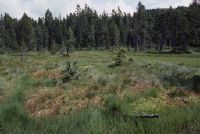
Title (German)
Flühli LU, Auf Salwiden, Hochmoorföhrenwald südöstlich des Weilers Turnschwand
Caption
Semi-open high moor mountain pine forest Türnliwald, habitat type Ledo-Pinion, photograph taken during the vegetation phase, UNESCO Entlebuch Biosphere Reserve, general view; keywords Documenta Natura: wetland.
Caption (German)
Halboffener Hochmoor-Bergföhrenwald Türnliwald, Lebensraumtyp Ledo-Pinion, Aufnahme während der Vegetationsphase, UNESCO-Biosphärenreservat Entlebuch, Gesamtansicht; Schlagworte Documenta Natura: Feuchtgebiet
Record Name
Dia_303-36296

Title (German)
Flühli LU, Auf Salwiden, Hochmoorföhrenwald südöstlich des Weilers Turnschwand
Caption
Semi-open high moor mountain pine forest Türnliwald, habitat type Ledo-Pinion, photograph taken during the vegetation phase, UNESCO Entlebuch Biosphere Reserve, general view; keywords Documenta Natura: wetland.
Caption (German)
Halboffener Hochmoor-Bergföhrenwald Türnliwald, Lebensraumtyp Ledo-Pinion, Aufnahme während der Vegetationsphase, UNESCO-Biosphärenreservat Entlebuch, Gesamtansicht; Schlagworte Documenta Natura: Feuchtgebiet
Record Name
Dia_303-36301