 E-PICS - ETHBIB.Bildarchiv


The images presented on this page are part of E-Pics, a service provided by the ETH-Bibliothek of ETH Zurich. You find here static medium resolution images published under the creative commons
CC-BY-SA license or with the Public Domain Mark. This means that you are free to share, copy and redistribute the material in any medium or format; that you are free to remix, transform, and build upon the material for any purpose, even commercially, under the following conditions: You must give appropriate credit, provide a link to the license, and indicate if changes were made.
- More information about E-Pics is available at https://www.e-pics.ethz.ch
- This catalog can also be accessed at https://ba.e-pics.ethz.ch/ . There you can download the image in a higher resolution.

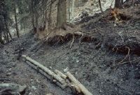
Title (German)
Chur GR, Im Schwarzwald ca. 350 m westlich der Bergstation Brambrüesch
Caption
Open ditches in the forest, partially flooded forest area, partial view; coordinates (LV03) of the camera location: 758150/188700; keywords Documenta Natura: mountain forest, thinning, reforestation, landslide obstruction drainage, road construction.
Caption (German)
Offene Wassergräben im Wald, teilweise überschwemmte Waldfläche, Teilansicht; Koordinaten (LV03) des Kamerastandorts: 758150/188700; Schlagworte Documenta Natura: Gebirgswald, Durchforstung, Aufforstung, Rutschverbauung Entwaesserung, Strassenbau
Record Name
Dia_303-22757

Title (German)
Chur GR, Im Schwarzwald ca. 350 m westlich der Bergstation Brambrüesch
Caption
Open ditches in the forest, partially flooded forest area, partial view; coordinates (LV03) of the camera location: 758150/188700; keywords Documenta Natura: mountain forest, thinning, reforestation, landslide obstruction drainage, road construction.
Caption (German)
Offene Wassergräben im Wald, teilweise überschwemmte Waldfläche, Teilansicht; Koordinaten (LV03) des Kamerastandorts: 758150/188700; Schlagworte Documenta Natura: Gebirgswald, Durchforstung, Aufforstung, Rutschverbauung Entwaesserung, Strassenbau
Record Name
Dia_303-22760

Title (German)
Chur GR, Im Schwarzwald ca. 350 m westlich der Bergstation Brambrüesch
Caption
Open ditches in the forest, partially flooded forest area, partial view; coordinates (LV03) of the camera location: 758150/188700; keywords Documenta Natura: mountain forest, thinning, reforestation, landslide deforestation, road construction
Caption (German)
Offene Wassergräben im Wald, teilweise überschwemmte Waldfläche, Teilansicht; Koordinaten (LV03) des Kamerastandorts: 758150/188700; Schlagworte Documenta Natura: Gebirgswald, Durchforstung, Aufforstung, Rutschverbauung Entwaesserung, Strassenbau
Record Name
Dia_303-22763

Title (German)
Chur GR, Im Schwarzwald ca. 350 m westlich der Bergstation Brambrüesch
Caption
Open ditches in the forest, partially flooded forest area, partial view; coordinates (LV03) of the camera location: 758150/188700; keywords Documenta Natura: mountain forest, thinning, reforestation, landslide deforestation, road construction
Caption (German)
Offene Wassergräben im Wald, teilweise überschwemmte Waldfläche, Teilansicht; Koordinaten (LV03) des Kamerastandorts: 758150/188700; Schlagworte Documenta Natura: Gebirgswald, Durchforstung, Aufforstung, Rutschverbauung Entwaesserung, Strassenbau
Record Name
Dia_303-22768

Title (German)
Chur GR, Im Schwarzwald ca. 350 m westlich der Bergstation Brambrüesch
Caption
Open ditches in the forest, partially flooded forest area, partial view; coordinates (LV03) of the camera location: 758150/188700; keywords Documenta Natura: mountain forest, thinning, reforestation, landslide obstruction drainage, road construction.
Caption (German)
Offene Wassergräben im Wald, teilweise überschwemmte Waldfläche, Teilansicht; Koordinaten (LV03) des Kamerastandorts: 758150/188700; Schlagworte Documenta Natura: Gebirgswald, Durchforstung, Aufforstung, Rutschverbauung Entwaesserung, Strassenbau
Record Name
Dia_303-22772

Title (German)
Chur GR, Im Schwarzwald ca. 350 m westlich der Bergstation Brambrüesch
Caption
Open ditches in the forest, partially flooded forest area, partial view; coordinates (LV03) of the camera location: 758150/188700; keywords Documenta Natura: mountain forest, thinning, reforestation, landslide deforestation, road construction
Caption (German)
Offene Wassergräben im Wald, teilweise überschwemmte Waldfläche, Teilansicht; Koordinaten (LV03) des Kamerastandorts: 758150/188700; Schlagworte Documenta Natura: Gebirgswald, Durchforstung, Aufforstung, Rutschverbauung Entwaesserung, Strassenbau
Record Name
Dia_303-22775
Title (German)
Chur GR, Im Schwarzwald ca. 350 m westlich der Bergstation Brambrüesch
Caption
Open ditch in the forest, structural measures (securing the slope), partial view; coordinates (LV03) of the camera location: 758150/188700; keywords Documenta Natura: mountain forest, thinning, reforestation, landslide obstruction drainage, road construction.
Caption (German)
Offener Wassergraben im Wald, bauliche Massnahmen (Sicherung der Böschung), Teilansicht; Koordinaten (LV03) des Kamerastandorts: 758150/188700; Schlagworte Documenta Natura: Gebirgswald, Durchforstung, Aufforstung, Rutschverbauung Entwaesserung, Strassenbau
Record Name
Dia_303-22778

Title (German)
Chur GR, Im Schwarzwald ca. 350 m westlich der Bergstation Brambrüesch
Caption
Open ditches in forest, partially flooded forest area, during vegetation phase, partial view; coordinates (LV03) of camera location: 758150/188700; keywords Documenta Natura: mountain forest, thinning, reforestation, landslide obstruction drainage, road construction.
Caption (German)
Offene Wassergräben im Wald, teilweise überschwemmte Waldfläche, während der Vegetationsphase, Teilansicht; Koordinaten (LV03) des Kamerastandorts: 758150/188700; Schlagworte Documenta Natura: Gebirgswald, Durchforstung, Aufforstung, Rutschverbauung Entwaesserung, Strassenbau
Record Name
Dia_303-22782

Title (German)
Chur GR, Im Schwarzwald ca. 350 m westlich der Bergstation Brambrüesch
Caption
Open ditches in forest, partially flooded forest area, during vegetation phase, partial view; coordinates (LV03) of camera location: 758150/188700; keywords Documenta Natura: mountain forest, thinning, reforestation, landslide obstruction drainage, road construction.
Caption (German)
Offene Wassergräben im Wald, teilweise überschwemmte Waldfläche, während der Vegetationsphase, Teilansicht; Koordinaten (LV03) des Kamerastandorts: 758150/188700; Schlagworte Documenta Natura: Gebirgswald, Durchforstung, Aufforstung, Rutschverbauung Entwaesserung, Strassenbau
Record Name
Dia_303-22785

Title (German)
Chur GR, Im Schwarzwald ca. 350 m westlich der Bergstation Brambrüesch
Caption
Open ditch in the forest, structural measures (securing the slope), during the vegetation phase, partial view; coordinates (LV03) of the camera location: 758150/188700; keywords Documenta Natura: mountain forest, thinning, reforestation, slide obstruction drainage, road construction.
Caption (German)
Offener Wassergraben im Wald, bauliche Massnahmen (Sicherung der Böschung), während der Vegetationsphase, Teilansicht; Koordinaten (LV03) des Kamerastandorts: 758150/188700; Schlagworte Documenta Natura: Gebirgswald, Durchforstung, Aufforstung, Rutschverbauung Entwaesserung, Strassenbau
Record Name
Dia_303-22788

Title (German)
Chur GR, Im Schwarzwald ca. 350 m westlich der Bergstation Brambrüesch
Caption
Open ditches in forest, partially flooded forest area, during vegetation phase, partial view; coordinates (LV03) of camera location: 758150/188700; keywords Documenta Natura: mountain forest, thinning, reforestation, landslide obstruction drainage, road construction.
Caption (German)
Offene Wassergräben im Wald, teilweise überschwemmte Waldfläche, während der Vegetationsphase, Teilansicht; Koordinaten (LV03) des Kamerastandorts: 758150/188700; Schlagworte Documenta Natura: Gebirgswald, Durchforstung, Aufforstung, Rutschverbauung Entwaesserung, Strassenbau
Record Name
Dia_303-22791

Title (German)
Chur GR, Im Schwarzwald ca. 350 m westlich der Bergstation Brambrüesch
Caption
Open ditch in forest, partially flooded forest area, during vegetation phase, partial view; coordinates (LV03) of camera location: 758150/188700; keywords Documenta Natura: mountain forest, thinning, reforestation, landslide obstruction drainage, road construction.
Caption (German)
Offener Wassergraben im Wald, teilweise überschwemmte Waldfläche, während der Vegetationsphase, Teilansicht; Koordinaten (LV03) des Kamerastandorts: 758150/188700; Schlagworte Documenta Natura: Gebirgswald, Durchforstung, Aufforstung, Rutschverbauung Entwaesserung, Strassenbau
Record Name
Dia_303-22793
Title (German)
Chur GR, Im Schwarzwald ca. 350 m westlich der Bergstation Brambrüesch
Caption
Open ditches in forest, partially flooded forest area, during vegetation phase, partial view; coordinates (LV03) of camera location: 758150/188700; keywords Documenta Natura: mountain forest, thinning, reforestation, landslide obstruction drainage, road construction.
Caption (German)
Offene Wassergräben im Wald, teilweise überschwemmte Waldfläche, während der Vegetationsphase, Teilansicht; Koordinaten (LV03) des Kamerastandorts: 758150/188700; Schlagworte Documenta Natura: Gebirgswald, Durchforstung, Aufforstung, Rutschverbauung Entwaesserung, Strassenbau
Record Name
Dia_303-22796

Title (German)
Chur GR, Im Schwarzwald ca. 350 m westlich der Bergstation Brambrüesch
Caption
Open ditches in forest, partially flooded forest area, during vegetation phase, partial view; coordinates (LV03) of camera location: 758150/188700; keywords Documenta Natura: mountain forest, thinning, reforestation, landslide obstruction drainage, road construction.
Caption (German)
Offene Wassergräben im Wald, teilweise überschwemmte Waldfläche, während der Vegetationsphase, Teilansicht; Koordinaten (LV03) des Kamerastandorts: 758150/188700; Schlagworte Documenta Natura: Gebirgswald, Durchforstung, Aufforstung, Rutschverbauung Entwaesserung, Strassenbau
Record Name
Dia_303-22799

Title (German)
Chur GR, Im Schwarzwald ca. 350 m westlich der Bergstation Brambrüesch
Caption
Open ditch in forest, partially flooded forest area, during vegetation phase, partial view; coordinates (LV03) of camera location: 758150/188700; keywords Documenta Natura: mountain forest, thinning, reforestation, landslide obstruction drainage, road construction.
Caption (German)
Offener Wassergraben im Wald, teilweise überschwemmte Waldfläche, während der Vegetationsphase, Teilansicht; Koordinaten (LV03) des Kamerastandorts: 758150/188700; Schlagworte Documenta Natura: Gebirgswald, Durchforstung, Aufforstung, Rutschverbauung Entwaesserung, Strassenbau
Record Name
Dia_303-22802

Title (German)
Chur GR, Im Schwarzwald ca. 350 m westlich der Bergstation Brambrüesch
Caption
Open ditches in forest, partially flooded forest area, during vegetation phase, partial view; coordinates (LV03) of camera location: 758150/188700; keywords Documenta Natura: mountain forest, thinning, reforestation, landslide obstruction drainage, road construction.
Caption (German)
Offene Wassergräben im Wald, teilweise überschwemmte Waldfläche, während der Vegetationsphase, Teilansicht; Koordinaten (LV03) des Kamerastandorts: 758150/188700; Schlagworte Documenta Natura: Gebirgswald, Durchforstung, Aufforstung, Rutschverbauung Entwaesserung, Strassenbau
Record Name
Dia_303-22805

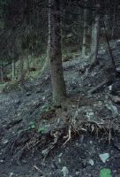
Title (German)
Chur GR, Im Schwarzwald ca. 350 m westlich der Bergstation Brambrüesch
Caption
View downslope of the unstable and heavily sodden forest area, partial view; coordinates (LV03) of camera location: 758150/188700; keywords Documenta Natura: mountain forest, thinning, reforestation, landslide obstruction drainage, road construction.
Caption (German)
Blick hangabwärts auf die unstabile und stark durchnässte Waldfläche, Teilansicht; Koordinaten (LV03) des Kamerastandorts: 758150/188700; Schlagworte Documenta Natura: Gebirgswald, Durchforstung, Aufforstung, Rutschverbauung Entwaesserung, Strassenbau
Record Name
Dia_303-22808

Title (German)
Chur GR, Im Schwarzwald ca. 350 m westlich der Bergstation Brambrüesch
Caption
Open ditches in forest, partially flooded forest area, during vegetation phase, partial view; coordinates (LV03) of camera location: 758150/188700; keywords Documenta Natura: mountain forest, thinning, reforestation, landslide obstruction drainage, road construction.
Caption (German)
Offene Wassergräben im Wald, teilweise überschwemmte Waldfläche, während der Vegetationsphase, Teilansicht; Koordinaten (LV03) des Kamerastandorts: 758150/188700; Schlagworte Documenta Natura: Gebirgswald, Durchforstung, Aufforstung, Rutschverbauung Entwaesserung, Strassenbau
Record Name
Dia_303-22811

Title (German)
Chur GR, Im Schwarzwald ca. 350 m westlich der Bergstation Brambrüesch
Caption
Open ditches in forest, partially flooded forest area, during vegetation phase, partial view; coordinates (LV03) of camera location: 758150/188700; keywords Documenta Natura: mountain forest, thinning, reforestation, landslide obstruction drainage, road construction.
Caption (German)
Offene Wassergräben im Wald, teilweise überschwemmte Waldfläche, während der Vegetationsphase, Teilansicht; Koordinaten (LV03) des Kamerastandorts: 758150/188700; Schlagworte Documenta Natura: Gebirgswald, Durchforstung, Aufforstung, Rutschverbauung Entwaesserung, Strassenbau
Record Name
Dia_303-22814

Title (German)
Chur GR, Im Schwarzwald ca. 350 m westlich der Bergstation Brambrüesch
Caption
Open ditches in forest, partially flooded forest area, during vegetation phase, partial view; coordinates (LV03) of camera location: 758150/188700; keywords Documenta Natura: mountain forest, thinning, reforestation, landslide obstruction drainage, road construction.
Caption (German)
Offene Wassergräben im Wald, teilweise überschwemmte Waldfläche, während der Vegetationsphase, Teilansicht; Koordinaten (LV03) des Kamerastandorts: 758150/188700; Schlagworte Documenta Natura: Gebirgswald, Durchforstung, Aufforstung, Rutschverbauung Entwaesserung, Strassenbau
Record Name
Dia_303-22817

Title (German)
Chur GR, Im Schwarzwald nordwestlich der Bergstation Brambrüesch, unterh. des Senders bei der Höhenkote 1595 m
Caption
View across the slope to the bare, deep landslide area with newly planted alders, first photograph 1990, partial view; coordinates (LV03) of camera location: 7586ff/1891ff; keywords Documenta Natura: mountain forest, thinning, reforestation, landslide deforestation, road construction
Caption (German)
Blick quer zum Hang auf die kahle, tiefgründige Rutschfläche mit neu angepflanzten Erlen, Erstaufnahme 1990, Teilansicht; Koordinaten (LV03) des Kamerastandorts: 7586ff/1891ff; Schlagworte Documenta Natura: Gebirgswald, Durchforstung, Aufforstung, Rutschverbauung Entwaesserung, Strassenbau
Record Name
Dia_303-22822

Title (German)
Chur GR, Im Schwarzwald nordwestlich der Bergstation Brambrüesch, unterh. des Senders bei der Höhenkote 1595 m
Caption
View upslope of the bare, deep landslide area with newly planted alders, first photograph 1990, partial view; coordinates (LV03) of camera location: 7586ff/1891ff; keywords Documenta Natura: mountain forest, thinning, reforestation, landslide deforestation, road construction
Caption (German)
Blick hangaufwärts auf die kahle, tiefgründige Rutschfläche mit neu angepflanzten Erlen, Erstaufnahme 1990, Teilansicht; Koordinaten (LV03) des Kamerastandorts: 7586ff/1891ff; Schlagworte Documenta Natura: Gebirgswald, Durchforstung, Aufforstung, Rutschverbauung Entwaesserung, Strassenbau
Record Name
Dia_303-22825

Title (German)
Chur GR, Im Schwarzwald nordwestlich der Bergstation Brambrüesch, unterh. des Senders bei der Höhenkote 1595 m
Caption
View across the slope to the bare, deep landslide area with newly planted alders, first photograph 1990, partial view; coordinates (LV03) of camera location: 7586ff/1891ff; keywords Documenta Natura: mountain forest, thinning, reforestation, landslide deforestation, road construction
Caption (German)
Blick quer zum Hang auf die kahle, tiefgründige Rutschfläche mit neu angepflanzten Erlen, Erstaufnahme 1990, Teilansicht; Koordinaten (LV03) des Kamerastandorts: 7586ff/1891ff; Schlagworte Documenta Natura: Gebirgswald, Durchforstung, Aufforstung, Rutschverbauung Entwaesserung, Strassenbau
Record Name
Dia_303-22828

Title (German)
Chur GR, Im Schwarzwald nordwestlich der Bergstation Brambrüesch, unterh. des Senders bei der Höhenkote 1595 m
Caption
View downslope of the bare, deep landslide area with newly planted alders, first photograph 1990, partial view; coordinates (LV03) of camera location: 7586ff/1891ff; keywords Documenta Natura: mountain forest, thinning, reforestation, landslide deforestation, road construction
Caption (German)
Blick hangabwärts auf die kahle, tiefgründige Rutschfläche mit neu angepflanzten Erlen, Erstaufnahme 1990, Teilansicht; Koordinaten (LV03) des Kamerastandorts: 7586ff/1891ff; Schlagworte Documenta Natura: Gebirgswald, Durchforstung, Aufforstung, Rutschverbauung Entwaesserung, Strassenbau
Record Name
Dia_303-22831

Title (German)
Chur GR, Im Schwarzwald nordwestlich der Bergstation Brambrüesch, unterh. des Senders bei der Höhenkote 1595 m
Caption
View downslope of the bare, deep landslide area with newly planted alders, first photograph 1990, partial view; coordinates (LV03) of camera location: 7586ff/1891ff; keywords Documenta Natura: mountain forest, thinning, reforestation, landslide deforestation, road construction
Caption (German)
Blick hangabwärts auf die kahle, tiefgründige Rutschfläche mit neu angepflanzten Erlen, Erstaufnahme 1990, Teilansicht; Koordinaten (LV03) des Kamerastandorts: 7586ff/1891ff; Schlagworte Documenta Natura: Gebirgswald, Durchforstung, Aufforstung, Rutschverbauung Entwaesserung, Strassenbau
Record Name
Dia_303-22834

Title (German)
Chur GR, Im Schwarzwald nordwestlich der Bergstation Brambrüesch, unterh. des Senders bei der Höhenkote 1595 m
Caption
View upslope of the landslide area with planted alders and natural young growth (spruce), 1st follow-up photo 1992, partial view; coordinates (LV03) of camera location: 7586ff/1891ff; keywords Documenta Natura: mountain forest, thinning, reforestation, landslide deforestation, road construction
Caption (German)
Blick hangaufwärts auf die Rutschfläche mit angepflanzten Erlen und natürlichem Jungwuchs (Fichte), 1. Folgeaufnahme 1992, Teilansicht; Koordinaten (LV03) des Kamerastandorts: 7586ff/1891ff; Schlagworte Documenta Natura: Gebirgswald, Durchforstung, Aufforstung, Rutschverbauung Entwaesserung, Strassenbau
Record Name
Dia_303-22837

Title (German)
Chur GR, Im Schwarzwald nordwestlich der Bergstation Brambrüesch, unterh. des Senders bei der Höhenkote 1595 m
Caption
View across the slope to the landslide area with planted alders, 1st follow-up photograph 1992, partial view; coordinates (LV03) of the camera location: 7586ff/1891ff; keywords Documenta Natura: mountain forest, thinning, reforestation, landslide deforestation, road construction
Caption (German)
Blick quer zum Hang auf die Rutschfläche mit angepflanzten Erlen, 1. Folgeaufnahme 1992, Teilansicht; Koordinaten (LV03) des Kamerastandorts: 7586ff/1891ff; Schlagworte Documenta Natura: Gebirgswald, Durchforstung, Aufforstung, Rutschverbauung Entwaesserung, Strassenbau
Record Name
Dia_303-22840

Title (German)
Chur GR, Im Schwarzwald nordwestlich der Bergstation Brambrüesch, unterh. des Senders bei der Höhenkote 1595 m
Caption
View upslope of the slide area with planted alders, 1st follow-up photograph 1992, partial view; coordinates (LV03) of camera location: 7586ff/1891ff; keywords Documenta Natura: mountain forest, thinning, reforestation, slide deforestation, road construction
Caption (German)
Blick hangaufwärts auf die Rutschfläche mit den angepflanzten Erlen, 1. Folgeaufnahme 1992, Teilansicht; Koordinaten (LV03) des Kamerastandorts: 7586ff/1891ff; Schlagworte Documenta Natura: Gebirgswald, Durchforstung, Aufforstung, Rutschverbauung Entwaesserung, Strassenbau
Record Name
Dia_303-22843

Title (German)
Chur GR, Im Schwarzwald nordwestlich der Bergstation Brambrüesch, unterh. des Senders bei der Höhenkote 1595 m
Caption
View across the slope to the slide area with planted alders, 1st follow-up photograph 1992, partial view; coordinates (LV03) of the camera location: 7586ff/1891ff; keywords Documenta Natura: mountain forest, thinning, reforestation, slide deforestation, road construction
Caption (German)
Blick quer zum Hang auf die Rutschfläche mit den angepflanzten Erlen, 1. Folgeaufnahme 1992, Teilansicht; Koordinaten (LV03) des Kamerastandorts: 7586ff/1891ff; Schlagworte Documenta Natura: Gebirgswald, Durchforstung, Aufforstung, Rutschverbauung Entwaesserung, Strassenbau
Record Name
Dia_303-22846

Title (German)
Chur GR, Im Schwarzwald nordwestlich der Bergstation Brambrüesch, unterh. des Senders bei der Höhenkote 1595 m
Caption
View downslope of the landslide area with planted alders, 1st follow-up photograph 1992, partial view; coordinates (LV03) of camera location: 7586ff/1891ff; keywords Documenta Natura: mountain forest, thinning, reforestation, landslide deforestation, road construction
Caption (German)
Blick hangabwärts auf die Rutschfläche mit den angepflanzten Erlen, 1. Folgeaufnahme 1992, Teilansicht; Koordinaten (LV03) des Kamerastandorts: 7586ff/1891ff; Schlagworte Documenta Natura: Gebirgswald, Durchforstung, Aufforstung, Rutschverbauung Entwaesserung, Strassenbau
Record Name
Dia_303-22850

Title (German)
Chur GR, Im Schwarzwald nordwestlich der Bergstation Brambrüesch, unterh. des Senders bei der Höhenkote 1595 m
Caption
View downslope of the landslide area with planted alders, 1st follow-up photograph 1992, partial view; coordinates (LV03) of the camera location: 7586ff/1891ff; keywords Documenta Natura: mountain forest, thinning, reforestation, landslide deforestation, road construction
Caption (German)
Blick hangabwärts auf die Rutschfläche mit den angepflanzten Erlen, 1. Folgeaufnahme 1992, Teilansicht; Koordinaten (LV03) des Kamerastandorts: 7586ff/1891ff; Schlagworte Documenta Natura: Gebirgswald, Durchforstung, Aufforstung, Rutschverbauung Entwaesserung, Strassenbau
Record Name
Dia_303-22853

Title (German)
Chur GR, Im Schwarzwald nordwestlich der Bergstation Brambrüesch, unterh. des Senders bei der Höhenkote 1595 m
Caption
View downslope of the landslide area with planted alders, 1st follow-up photograph 1992, partial view; coordinates (LV03) of camera location: 7586ff/1891ff; keywords Documenta Natura: mountain forest, thinning, reforestation, landslide deforestation, road construction
Caption (German)
Blick hangabwärts auf die Rutschfläche mit den angepflanzten Erlen, 1. Folgeaufnahme 1992, Teilansicht; Koordinaten (LV03) des Kamerastandorts: 7586ff/1891ff; Schlagworte Documenta Natura: Gebirgswald, Durchforstung, Aufforstung, Rutschverbauung Entwaesserung, Strassenbau
Record Name
Dia_303-22855

Title (German)
Chur GR, Im Schwarzwald nordwestlich der Bergstation Brambrüesch, unterh. des Senders bei der Höhenkote 1595 m
Caption
View downslope of the landslide area with planted alders, 1st follow-up photograph 1992, partial view; coordinates (LV03) of camera location: 7586ff/1891ff; keywords Documenta Natura: mountain forest, thinning, reforestation, landslide deforestation, road construction
Caption (German)
Blick hangabwärts auf die Rutschfläche mit den angepflanzten Erlen, 1. Folgeaufnahme 1992, Teilansicht; Koordinaten (LV03) des Kamerastandorts: 7586ff/1891ff; Schlagworte Documenta Natura: Gebirgswald, Durchforstung, Aufforstung, Rutschverbauung Entwaesserung, Strassenbau
Record Name
Dia_303-22858

Title (German)
Chur GR, Im Schwarzwald nordwestlich der Bergstation Brambrüesch, unterh. des Senders bei der Höhenkote 1595 m
Caption
View downslope of the landslide area with planted alders, 1st follow-up photograph 1992, partial view; coordinates (LV03) of camera location: 7586ff/1891ff; keywords Documenta Natura: mountain forest, thinning, reforestation, landslide deforestation, road construction
Caption (German)
Blick hangabwärts auf die Rutschfläche mit den angepflanzten Erlen, 1. Folgeaufnahme 1992, Teilansicht; Koordinaten (LV03) des Kamerastandorts: 7586ff/1891ff; Schlagworte Documenta Natura: Gebirgswald, Durchforstung, Aufforstung, Rutschverbauung Entwaesserung, Strassenbau
Record Name
Dia_303-22861

Title (German)
Chur GR, Im Schwarzwald nordwestlich der Bergstation Brambrüesch, unterh. des Senders bei der Höhenkote 1595 m
Caption
View across the slope to the slide area with planted alders, 1st follow-up photograph 1992, general view; coordinates (LV03) of the camera location: 7586ff/1891ff; keywords Documenta Natura: mountain forest, thinning, reforestation, slide deforestation, road construction
Caption (German)
Blick quer zum Hang auf die Rutschfläche mit den angepflanzten Erlen, 1. Folgeaufnahme 1992, Gesamtansicht; Koordinaten (LV03) des Kamerastandorts: 7586ff/1891ff; Schlagworte Documenta Natura: Gebirgswald, Durchforstung, Aufforstung, Rutschverbauung Entwaesserung, Strassenbau
Record Name
Dia_303-22866

Title (German)
Chur GR, Im Schwarzwald nordwestlich der Bergstation Brambrüesch, unterh. des Senders bei der Höhenkote 1595 m
Caption
View downslope of the landslide area with planted alders, 1st follow-up photograph 1992, partial view; coordinates (LV03) of camera location: 7586ff/1891ff; keywords Documenta Natura: mountain forest, thinning, reforestation, landslide deforestation, road construction
Caption (German)
Blick hangabwärts auf die Rutschfläche mit den angepflanzten Erlen, 1. Folgeaufnahme 1992, Teilansicht; Koordinaten (LV03) des Kamerastandorts: 7586ff/1891ff; Schlagworte Documenta Natura: Gebirgswald, Durchforstung, Aufforstung, Rutschverbauung Entwaesserung, Strassenbau
Record Name
Dia_303-22871

Title (German)
Chur GR, Im Schwarzwald nordwestlich der Bergstation Brambrüesch, unterh. des Senders bei der Höhenkote 1595 m
Caption
View downslope of the landslide area with planted alders, 1st follow-up photograph 1992, partial view; coordinates (LV03) of camera location: 7586ff/1891ff; keywords Documenta Natura: mountain forest, thinning, reforestation, landslide deforestation, road construction
Caption (German)
Blick hangabwärts auf die Rutschfläche mit den angepflanzten Erlen, 1. Folgeaufnahme 1992, Teilansicht; Koordinaten (LV03) des Kamerastandorts: 7586ff/1891ff; Schlagworte Documenta Natura: Gebirgswald, Durchforstung, Aufforstung, Rutschverbauung Entwaesserung, Strassenbau
Record Name
Dia_303-22874

Title (German)
Chur GR, Im Schwarzwald nordwestlich der Bergstation Brambrüesch, unterh. des Senders bei der Höhenkote 1595 m
Caption
View across the slope to the slide area with planted alders, 1st follow-up photograph 1992, partial view; coordinates (LV03) of the camera location: 7586ff/1891ff; keywords Documenta Natura: mountain forest, thinning, reforestation, slide deforestation, road construction
Caption (German)
Blick quer zum Hang auf die Rutschfläche mit den angepflanzten Erlen, 1. Folgeaufnahme 1992, Teilansicht; Koordinaten (LV03) des Kamerastandorts: 7586ff/1891ff; Schlagworte Documenta Natura: Gebirgswald, Durchforstung, Aufforstung, Rutschverbauung Entwaesserung, Strassenbau
Record Name
Dia_303-22877

Title (German)
Chur GR, Im Schwarzwald nordwestlich der Bergstation Brambrüesch, unterh. des Senders bei der Höhenkote 1595 m
Caption
Tree population on the slide surface, 1st follow-up photograph 1992, partial view; coordinates (LV03) of the camera location: 7586ff/1891ff; keywords Documenta Natura: mountain forest, thinning, reforestation, slide deforestation, road construction
Caption (German)
Baumbestand auf der Rutschfläche, 1. Folgeaufnahme 1992, Teilansicht; Koordinaten (LV03) des Kamerastandorts: 7586ff/1891ff; Schlagworte Documenta Natura: Gebirgswald, Durchforstung, Aufforstung, Rutschverbauung Entwaesserung, Strassenbau
Record Name
Dia_303-22880

Title (German)
Chur GR, Im Schwarzwald nordwestlich der Bergstation Brambrüesch, unterh. des Senders bei der Höhenkote 1595 m
Caption
View across the slope to the slide area with planted alders, 1st follow-up photograph 1992, partial view; coordinates (LV03) of the camera location: 7586ff/1891ff; keywords Documenta Natura: mountain forest, thinning, reforestation, slide deforestation, road construction
Caption (German)
Blick quer zum Hang auf die Rutschfläche mit den angepflanzten Erlen, 1. Folgeaufnahme 1992, Teilansicht; Koordinaten (LV03) des Kamerastandorts: 7586ff/1891ff; Schlagworte Documenta Natura: Gebirgswald, Durchforstung, Aufforstung, Rutschverbauung Entwaesserung, Strassenbau
Record Name
Dia_303-22883

Title (German)
Chur GR, Im Schwarzwald nordwestlich der Bergstation Brambrüesch, unterh. des Senders bei der Höhenkote 1595 m
Caption
View across the slope to the slide area with the planted alders and young growth, 2nd follow-up photograph 1997, partial view; coordinates (LV03) of the camera location: 7586ff/1891ff; keywords Documenta Natura: mountain forest, thinning, reforestation, slide deforestation, road construction
Caption (German)
Blick quer zum Hang auf die Rutschfläche mit den gepflanzten Erlen und dem Jungwuchs, 2. Folgeaufnahme 1997, Teilansicht; Koordinaten (LV03) des Kamerastandorts: 7586ff/1891ff; Schlagworte Documenta Natura: Gebirgswald, Durchforstung, Aufforstung, Rutschverbauung Entwaesserung, Strassenbau
Record Name
Dia_303-22886

Title (German)
Chur GR, Im Schwarzwald nordwestlich der Bergstation Brambrüesch, unterh. des Senders bei der Höhenkote 1595 m
Caption
View upslope of the landslide area with planted alders and young growth, 2nd follow-up photograph 1997, partial view; coordinates (LV03) of camera location: 7586ff/1891ff; keywords Documenta Natura: mountain forest, thinning, reforestation, landslide deforestation, road construction
Caption (German)
Blick hangaufwärts auf die Rutschfläche mit den gepflanzten Erlen und dem Jungwuchs, 2. Folgeaufnahme 1997, Teilansicht; Koordinaten (LV03) des Kamerastandorts: 7586ff/1891ff; Schlagworte Documenta Natura: Gebirgswald, Durchforstung, Aufforstung, Rutschverbauung Entwaesserung, Strassenbau
Record Name
Dia_303-22892

Title (German)
Chur GR, Im Schwarzwald nordwestlich der Bergstation Brambrüesch, unterh. des Senders bei der Höhenkote 1595 m
Caption
View downslope of the landslide area with planted alders and young growth, visible crack, 2nd follow-up photograph 1997, partial view; coordinates (LV03) of the camera location: 7586ff/1891ff; keywords Documenta Natura: mountain forest, thinning, reforestation, landslide deforestation, road construction
Caption (German)
Blick hangabwärts auf die Rutschfläche mit den gepflanzten Erlen und dem Jungwuchs, sichtbare Anrissstelle, 2. Folgeaufnahme 1997, Teilansicht; Koordinaten (LV03) des Kamerastandorts: 7586ff/1891ff; Schlagworte Documenta Natura: Gebirgswald, Durchforstung, Aufforstung, Rutschverbauung Entwaesserung, Strassenbau
Record Name
Dia_303-22901

Title (German)
Chur GR, Im Schwarzwald nordwestlich der Bergstation Brambrüesch, unterh. des Senders bei der Höhenkote 1595 m
Caption
View downslope of the landslide area with planted alders and young growth, 2nd follow-up photograph 1997, partial view; coordinates (LV03) of camera location: 7586ff/1891ff; keywords Documenta Natura: mountain forest, thinning, reforestation, landslide deforestation, road construction
Caption (German)
Blick hangabwärts auf die Rutschfläche mit den gepflanzten Erlen und dem Jungwuchs, 2. Folgeaufnahme 1997, Teilansicht; Koordinaten (LV03) des Kamerastandorts: 7586ff/1891ff; Schlagworte Documenta Natura: Gebirgswald, Durchforstung, Aufforstung, Rutschverbauung Entwaesserung, Strassenbau
Record Name
Dia_303-22907

Title (German)
Chur GR, Im Schwarzwald nordwestlich der Bergstation Brambrüesch, unterh. des Senders bei der Höhenkote 1595 m
Caption
View downslope of the landslide area with planted alders and young growth, 2nd follow-up photograph 1997, partial view; coordinates (LV03) of the camera location: 7586ff/1891ff; keywords Documenta Natura: mountain forest, thinning, reforestation, landslide deforestation, road construction
Caption (German)
Blick hangabwärts auf die Rutschfläche mit den gepflanzten Erlen und dem Jungwuchs, 2. Folgeaufnahme 1997, Teilansicht; Koordinaten (LV03) des Kamerastandorts: 7586ff/1891ff; Schlagworte Documenta Natura: Gebirgswald, Durchforstung, Aufforstung, Rutschverbauung Entwaesserung, Strassenbau
Record Name
Dia_303-22917

Title (German)
Chur GR, Im Schwarzwald nordwestlich der Bergstation Brambrüesch, unterh. des Senders bei der Höhenkote 1595 m
Caption
View across the slope to the slide area with the planted alders and young growth, 2nd follow-up photograph 1997, partial view; coordinates (LV03) of the camera location: 7586ff/1891ff; keywords Documenta Natura: mountain forest, thinning, reforestation, slide deforestation, road construction
Caption (German)
Blick quer zum Hang auf die Rutschfläche mit den gepflanzten Erlen und dem Jungwuchs, 2. Folgeaufnahme 1997, Teilansicht; Koordinaten (LV03) des Kamerastandorts: 7586ff/1891ff; Schlagworte Documenta Natura: Gebirgswald, Durchforstung, Aufforstung, Rutschverbauung Entwaesserung, Strassenbau
Record Name
Dia_303-22930

Title (German)
Chur GR, Nordwestansicht des Nordwesthanges mit dem Schwarzwald, im Vordergrund die Weide Foral
Caption
Northwest view of the northwest slope with the Black Forest, in the foreground the pasture Foral with hedges and scrub forest, partial view; coordinates (LV03) of the camera location: 757550/189950; keywords Documenta Natura: mountain forest, thinning, reforestation, landslide obstruction drainage, road construction.
Caption (German)
Nordwestansicht des Nordwesthanges mit dem Schwarzwald, im Vordergrund die Weide Foral mit Hecken und Gebüschwald, Teilansicht; Koordinaten (LV03) des Kamerastandorts: 757550/189950; Schlagworte Documenta Natura: Gebirgswald, Durchforstung, Aufforstung, Rutschverbauung Entwaesserung, Strassenbau
Record Name
Dia_303-22938

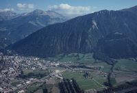
Title (German)
Chur GR, Felsberg GR, Blick von der Calanda auf Chur mit Talboden und Waffenplatz, im Hintergrund der Schwarzwald, z. T. Blick ins Schanfigg, Gebirgskette mit Weisshorn, Gürgaletsch und Furggabüel
Caption
View from the Calanda to Chur with the valley floor and the area of the armory, the Rhine, the A13 highway, the Black Forest in the background, view into the Schanfigg, the Gebrig chain with the Weisshorn, Gürgaletsch and Furggabüel, photograph taken in 1990, view from opposite slopes, general view; keywords Documenta Natura: mountain forest, thinning, reforestation, landslide deforestation, road construction
Caption (German)
Blick von der Calanda auf Chur mit Talboden und Waffenplatzareal, Rhein, Autobahn A13, im Hintergrund der Schwarzwald, Blick ins Schanfigg, Gebrigskette mit Weisshorn, Gürgaletsch und Furggabüel, Aufnahme 1990, Gegenhangaufnahme, Gesamtansicht; Schlagworte Documenta Natura: Gebirgswald, Durchforstung, Aufforstung, Rutschverbauung Entwaesserung, Strassenbau
Record Name
Dia_303-22942

Title (German)
Chur GR, Felsberg GR, Blick von der Calanda auf Chur mit Talboden und Waffenplatz, im Hintergrund der Schwarzwald, z. T. Blick ins Schanfigg, Gebirgskette mit Weisshorn, Gürgaletsch und Furggabüel
Caption
View from the Calanda to the western part of Chur with the valley floor and the Waffenplatz area, the Rhine, the A13 freeway, the Black Forest in the background, view into the Schanfigg, the Gebrig chain with the Weisshorn, Gürgaletsch and Furggabüel, photograph taken in 1990, view from opposite slopes, general view; keywords Documenta Natura: mountain forest, thinning, reforestation, landslide deforestation, road construction
Caption (German)
Blick von der Calanda auf den westlichen Teil von Chur mit Talboden und Waffenplatzareal, Rhein, Autobahn A13, im Hintergrund der Schwarzwald, Blick ins Schanfigg, Gebrigskette mit Weisshorn, Gürgaletsch und Furggabüel, AUfnahme 1990, Gegenhangaufnahme, Gesamtansicht; Schlagworte Documenta Natura: Gebirgswald, Durchforstung, Aufforstung, Rutschverbauung Entwaesserung, Strassenbau
Record Name
Dia_303-22944
Title (German)
Chur GR, Felsberg GR, Blick von der Calanda auf Chur mit Talboden und Waffenplatz, im Hintergrund der Schwarzwald, z. T. Blick ins Schanfigg, Gebirgskette mit Weisshorn, Gürgaletsch und Furggabüel
Caption
View from the Calanda to the western part of Chur with the valley floor and the Waffenplatz area, the Rhine, the A13 freeway, the Black Forest in the background, view into the Schanfigg, the Gebrig chain with the Weisshorn, Gürgaletsch and Furggabüel, photograph taken in 1990, reverse slope photograph, general view; keywords Documenta Natura: mountain forest, thinning, reforestation, landslide deforestation, road construction
Caption (German)
Blick von der Calanda auf den westlichen Teil von Chur mit Talboden und Waffenplatzareal, Rhein, Autobahn A13, im Hintergrund der Schwarzwald, Blick ins Schanfigg, Gebrigskette mit Weisshorn, Gürgaletsch und Furggabüel, Aufnahme 1990, Gegenhangaufnahme, Gesamtansicht; Schlagworte Documenta Natura: Gebirgswald, Durchforstung, Aufforstung, Rutschverbauung Entwaesserung, Strassenbau
Record Name
Dia_303-22947

Title (German)
Chur GR, Felsberg GR, Blick von der Calanda auf Chur mit Talboden und Waffenplatz, im Hintergrund der Schwarzwald, z. T. Blick ins Schanfigg, Gebirgskette mit Weisshorn, Gürgaletsch und Furggabüel
Caption
View from the Calanda to Chur with the valley floor and the area of the armory, the Rhine, the A13 freeway, the Black Forest in the background, view into the Schanfigg, the Gebrig chain with the Weisshorn, Gürgaletsch and Furggabüel, photograph taken in 1992, view from opposite slopes, general view; keywords Documenta Natura: mountain forest, thinning, reforestation, landslide deforestation, road construction
Caption (German)
Blick von der Calanda auf Chur mit Talboden und Waffenplatzareal, Rhein, Autobahn A13, im Hintergrund der Schwarzwald, Blick ins Schanfigg, Gebrigskette mit Weisshorn, Gürgaletsch und Furggabüel, Aufnahme 1992, Gegenhangaufnahme, Gesamtansicht; Schlagworte Documenta Natura: Gebirgswald, Durchforstung, Aufforstung, Rutschverbauung Entwaesserung, Strassenbau
Record Name
Dia_303-22950

Title (German)
Chur GR, Felsberg GR, Blick von der Calanda auf Chur mit Talboden und Waffenplatz, im Hintergrund der Schwarzwald, z. T. Blick ins Schanfigg, Gebirgskette mit Weisshorn, Gürgaletsch und Furggabüel
Caption
View from the Calanda to Chur with the valley floor and the area of the armory, the Rhine, the A13 freeway, the Black Forest in the background, view into the Schanfigg, the Gebrig chain with the Weisshorn, Gürgaletsch and Furggabüel, photograph taken in 1992, view from opposite slopes, general view; keywords Documenta Natura: mountain forest, thinning, reforestation, landslide deforestation, road construction
Caption (German)
Blick von der Calanda auf Chur mit Talboden und Waffenplatzareal, Rhein, Autobahn A13, im Hintergrund der Schwarzwald, Blick ins Schanfigg, Gebrigskette mit Weisshorn, Gürgaletsch und Furggabüel, Aufnahme 1992, Gegenhangaufnahme, Gesamtansicht; Schlagworte Documenta Natura: Gebirgswald, Durchforstung, Aufforstung, Rutschverbauung Entwaesserung, Strassenbau
Record Name
Dia_303-22953

Title (German)
Chur GR, Felsberg GR, Blick von der Calanda auf Chur mit Talboden und Waffenplatz, im Hintergrund der Schwarzwald, z. T. Blick ins Schanfigg, Gebirgskette mit Weisshorn, Gürgaletsch und Furggabüel
Caption
View from the Calanda to the western part of Chur with the valley floor and the Waffenplatz area, the Rhine, the A13 freeway, the Black Forest in the background, photograph taken in 1992, reverse slope photograph, general view; keywords Documenta Natura: mountain forest, thinning, reforestation, landslide deforestation, road construction
Caption (German)
Blick von der Calanda auf den westlichen Teil von Chur mit Talboden und Waffenplatzareal, Rhein, Autobahn A13, im Hintergrund der Schwarzwald, Aufnahme 1992, Gegenhangaufnahme, Gesamtansicht; Schlagworte Documenta Natura: Gebirgswald, Durchforstung, Aufforstung, Rutschverbauung Entwaesserung, Strassenbau
Record Name
Dia_303-22957

Title (German)
Chur GR, Nordwestansicht des Nordwesthanges mit dem Schwarzwald, im Vordergrund Chur mit Talboden, Blick ins Schanfigg, Gebirgskette mit Weisshorn, Gürgaletsch und Furggabüel
Caption
Northwest view of the northwest slope with the Black Forest, in the foreground partly Chur with valley floor, view into Schanfigg, mountain range with the Weisshorn, Gürgaletsch and Furggabüel, first photograph 1992, reverse slope photograph, general view; coordinates (LV03) of the camera location: 756480/192500; keywords Documenta Natura: mountain forest, thinning, reforestation, landslide deforestation, road construction
Caption (German)
Nordwestansicht des Nordwesthanges mit dem Schwarzwald, im Vordergrund teilweise Chur mit Talboden, Blick ins Schanfigg, Gebirgskette mit dem Weisshorn, Gürgaletsch und Furggabüel, Erstaufnahme 1992, Gegenhangaufnahme, Gesamtansicht; Koordinaten (LV03) des Kamerastandorts: 756480/192500; Schlagworte Documenta Natura: Gebirgswald, Durchforstung, Aufforstung, Rutschverbauung Entwaesserung, Strassenbau
Record Name
Dia_303-22960

Title (German)
Chur GR, Im Gattertobel bei Foval
Caption
Old and new stream obstructions (barriers and sills) in the Bachtobel, general view; coordinates (LV03) of the camera location: 758100/189850; keywords Documenta Natura: mountain forest, thinning, reforestation, landslide obstruction drainage, road construction
Caption (German)
Alte und neuen Bachverbauungen (Sperren und Schwellen) im Bachtobel, Gesamtansicht; Koordinaten (LV03) des Kamerastandorts: 758100/189850; Schlagworte Documenta Natura: Gebirgswald, Durchforstung, Aufforstung, Rutschverbauung Entwaesserung, Strassenbau
Record Name
Dia_303-22966

Title (German)
Chur GR, Im Gattertobel bei Foval
Caption
Old and new stream obstructions (barriers and sills) in the Bachtobel, general view; coordinates (LV03) of the camera location: 758100/189850; keywords Documenta Natura: mountain forest, thinning, reforestation, landslide obstruction drainage, road construction
Caption (German)
Alte und neuen Bachverbauungen (Sperren und Schwellen) im Bachtobel, Gesamtansicht; Koordinaten (LV03) des Kamerastandorts: 758100/189850; Schlagworte Documenta Natura: Gebirgswald, Durchforstung, Aufforstung, Rutschverbauung Entwaesserung, Strassenbau
Record Name
Dia_303-22968

Title (German)
Chur GR, Im Gattertobel bei Foval
Caption
Old and new stream obstructions (barriers and sills) in the stream valley, partial view; coordinates (LV03) of the camera location: 758100/189850; keywords Documenta Natura: mountain forest, thinning, reforestation, slide obstruction drainage, road construction
Caption (German)
Alte und neuen Bachverbauungen (Sperren und Schwellen) im Bachtobel, Teilansicht; Koordinaten (LV03) des Kamerastandorts: 758100/189850; Schlagworte Documenta Natura: Gebirgswald, Durchforstung, Aufforstung, Rutschverbauung Entwaesserung, Strassenbau
Record Name
Dia_303-22971

Title (German)
Chur GR, Im Gattertobel bei Foval
Caption
Old and new stream obstructions (barriers and sills) in the Bachtobel, general view; coordinates (LV03) of the camera location: 758100/189850; keywords Documenta Natura: mountain forest, thinning, reforestation, landslide obstruction drainage, road construction
Caption (German)
Alte und neuen Bachverbauungen (Sperren und Schwellen) im Bachtobel, Gesamtansicht; Koordinaten (LV03) des Kamerastandorts: 758100/189850; Schlagworte Documenta Natura: Gebirgswald, Durchforstung, Aufforstung, Rutschverbauung Entwaesserung, Strassenbau
Record Name
Dia_303-22974

Title (German)
Chur GR, Im Gattertobel bei Foval
Caption
Old and new stream obstructions (barriers and sills) in the stream valley, partial view; coordinates (LV03) of the camera location: 758100/189850; keywords Documenta Natura: mountain forest, thinning, reforestation, slide obstruction drainage, road construction
Caption (German)
Alte und neuen Bachverbauungen (Sperren und Schwellen) im Bachtobel, Teilansicht; Koordinaten (LV03) des Kamerastandorts: 758100/189850; Schlagworte Documenta Natura: Gebirgswald, Durchforstung, Aufforstung, Rutschverbauung Entwaesserung, Strassenbau
Record Name
Dia_303-22977

Title (German)
Chur GR, Im Gattertobel bei Foval
Caption
Old and new stream obstructions (barriers and sills) in the Bachtobel, general view; coordinates (LV03) of the camera location: 758100/189850; keywords Documenta Natura: mountain forest, thinning, reforestation, landslide obstruction drainage, road construction
Caption (German)
Alte und neuen Bachverbauungen (Sperren und Schwellen) im Bachtobel, Gesamtansicht; Koordinaten (LV03) des Kamerastandorts: 758100/189850; Schlagworte Documenta Natura: Gebirgswald, Durchforstung, Aufforstung, Rutschverbauung Entwaesserung, Strassenbau
Record Name
Dia_303-22980

Title (German)
Chur GR, Im Gattertobel bei Foval
Caption
Crossroads in the forest with machine path to the stream embankments, partial view; coordinates (LV03) of the camera location: 758100/189850; keywords Documenta Natura: mountain forest, thinning, reforestation, slide embankment drainage, road construction.
Caption (German)
Kreuzung im Wald mit Maschinenweg zu den Bachverbauungen, Teilansicht; Koordinaten (LV03) des Kamerastandorts: 758100/189850; Schlagworte Documenta Natura: Gebirgswald, Durchforstung, Aufforstung, Rutschverbauung Entwaesserung, Strassenbau
Record Name
Dia_303-22983

Title (German)
Chur GR, Am Ende des Gattertobel beim Weiler Foval
Caption
Debris trap of the Gatterbach at the edge of the forest, first photograph shortly after completion (1990), partial view; coordinates (LV03) of the camera location: 758100/189900; keywords Documenta Natura: mountain forest, thinning, reforestation, landslide deforestation, road construction
Caption (German)
Schuttfang des Gatterbaches am Waldrand, Erstaufnahme kurz nach der Fertigstellung (1990), Teilansicht; Koordinaten (LV03) des Kamerastandorts: 758100/189900; Schlagworte Documenta Natura: Gebirgswald, Durchforstung, Aufforstung, Rutschverbauung Entwaesserung, Strassenbau
Record Name
Dia_303-22986

Title (German)
Chur GR, Am Ende des Gattertobel beim Weiler Foval
Caption
Debris trap of the Gatterbach at the edge of the forest, first photograph shortly after completion (1990), partial view; coordinates (LV03) of the camera location: 758100/189900; keywords Documenta Natura: mountain forest, thinning, reforestation, landslide deforestation, road construction
Caption (German)
Schuttfang des Gatterbaches am Waldrand, Erstaufnahme kurz nach der Fertigstellung (1990), Teilansicht; Koordinaten (LV03) des Kamerastandorts: 758100/189900; Schlagworte Documenta Natura: Gebirgswald, Durchforstung, Aufforstung, Rutschverbauung Entwaesserung, Strassenbau
Record Name
Dia_303-22990

Title (German)
Chur GR, Am Ende des Gattertobel beim Weiler Foval
Caption
Debris trap of the Gatterbach at the edge of the forest, first photograph shortly after completion (1990), general view; coordinates (LV03) of the camera location: 758100/189900; keywords Documenta Natura: mountain forest, thinning, reforestation, landslide deforestation, road construction
Caption (German)
Schuttfang des Gatterbaches am Waldrand, Erstaufnahme kurz nach der Fertigstellung (1990), Gesamtansicht; Koordinaten (LV03) des Kamerastandorts: 758100/189900; Schlagworte Documenta Natura: Gebirgswald, Durchforstung, Aufforstung, Rutschverbauung Entwaesserung, Strassenbau
Record Name
Dia_303-22993

Title (German)
Chur GR, Am Ende des Gattertobel beim Weiler Foval
Caption
Debris trap of the Gatterbach at the edge of the forest, first photograph shortly after completion (1990), general view; coordinates (LV03) of the camera location: 758100/189900; keywords Documenta Natura: mountain forest, thinning, reforestation, landslide deforestation, road construction
Caption (German)
Schuttfang des Gatterbaches am Waldrand, Erstaufnahme kurz nach der Fertigstellung (1990), Gesamtansicht; Koordinaten (LV03) des Kamerastandorts: 758100/189900; Schlagworte Documenta Natura: Gebirgswald, Durchforstung, Aufforstung, Rutschverbauung Entwaesserung, Strassenbau
Record Name
Dia_303-22996

Title (German)
Chur GR, Am Ende des Gattertobel beim Weiler Foval
Caption
Debris trap of the Gatterbach at the edge of the forest filled with wood and alluvial material, 1st follow-up photograph 1992, partial view; coordinates (LV03) of the camera location: 758100/189900; keywords Documenta Natura: mountain forest, thinning, reforestation, landslide deforestation, clearing, road construction
Caption (German)
Mit Holz und Schwemmaterial gefüllter Schuttfang des Gatterbaches am Waldrand, 1. Folgeaufnahme 1992, Teilansicht; Koordinaten (LV03) des Kamerastandorts: 758100/189900; Schlagworte Documenta Natura: Gebirgswald, Durchforstung, Aufforstung, Rutschverbauung Entwaesserung, Strassenbau
Record Name
Dia_303-22997

Title (German)
Chur GR, Am Ende des Gattertobel beim Weiler Foval
Caption
Debris trap of the Gatterbach at the edge of the forest filled with wood and alluvial material, 1st follow-up photograph 1992, partial view; coordinates (LV03) of the camera location: 758100/189900; keywords Documenta Natura: mountain forest, thinning, reforestation, landslide deforestation, clearing, road construction
Caption (German)
Mit Holz und Schwemmaterial gefüllter Schuttfang des Gatterbaches am Waldrand, 1. Folgeaufnahme 1992, Teilansicht; Koordinaten (LV03) des Kamerastandorts: 758100/189900; Schlagworte Documenta Natura: Gebirgswald, Durchforstung, Aufforstung, Rutschverbauung Entwaesserung, Strassenbau
Record Name
Dia_303-23000

Title (German)
Chur GR, Am Ende des Gattertobel beim Weiler Foval
Caption
Debris trap of the Gatterbach at the edge of the forest filled with wood and alluvial material, 1st follow-up photograph 1992, partial view; coordinates (LV03) of the camera location: 758100/189900; keywords Documenta Natura: mountain forest, thinning, reforestation, landslide deforestation, clearing, road construction
Caption (German)
Mit Holz und Schwemmaterial gefüllter Schuttfang des Gatterbaches am Waldrand, 1. Folgeaufnahme 1992, Teilansicht; Koordinaten (LV03) des Kamerastandorts: 758100/189900; Schlagworte Documenta Natura: Gebirgswald, Durchforstung, Aufforstung, Rutschverbauung Entwaesserung, Strassenbau
Record Name
Dia_303-23007

Title (German)
Chur GR, Am Ende des Gattertobel beim Weiler Foval
Caption
Debris trap of the Gatterbach at the edge of the forest filled with wood and alluvial material, 1st follow-up photograph 1992, partial view; coordinates (LV03) of the camera location: 758100/189900; keywords Documenta Natura: mountain forest, thinning, reforestation, landslide deforestation, clearing, road construction
Caption (German)
Mit Holz und Schwemmaterial gefüllter Schuttfang des Gatterbaches am Waldrand, 1. Folgeaufnahme 1992, Teilansicht; Koordinaten (LV03) des Kamerastandorts: 758100/189900; Schlagworte Documenta Natura: Gebirgswald, Durchforstung, Aufforstung, Rutschverbauung Entwaesserung, Strassenbau
Record Name
Dia_303-23012

Title (German)
Chur GR, Am Ende des Gattertobel beim Weiler Foval
Caption
Further debris trap of the Gatterbach at the edge of the forest, during the construction phase 1992, partial view; coordinates (LV03) of the camera location: 758100/189900; keywords Documenta Natura: mountain forest, thinning, reforestation, landslide deforestation, road construction
Caption (German)
Weiterer Schuttfang des Gatterbaches am Waldrand, während der Bauphase 1992, Teilansicht; Koordinaten (LV03) des Kamerastandorts: 758100/189900; Schlagworte Documenta Natura: Gebirgswald, Durchforstung, Aufforstung, Rutschverbauung Entwaesserung, Strassenbau
Record Name
Dia_303-23017

Title (German)
Chur GR, Am Ende des Wassertobel bei der Weide Trist
Caption
Debris trap of the water stream at the edge of the forest, in the background western part of Chur, general view; keywords Documenta Natura: mountain forest, thinning, reforestation, landslide deforestation, road construction
Caption (German)
Schuttfang des Wasserbaches am Waldrand, im Hintergrund westlicher Teil von Chur, Gesamtansicht; Schlagworte Documenta Natura: Gebirgswald, Durchforstung, Aufforstung, Rutschverbauung Entwaesserung, Strassenbau
Record Name
Dia_303-23019

Title (German)
Chur GR, Am Ende des Wassertobel bei der Weide Trist
Caption
Debris trap of the water stream at the edge of the forest, partial view; Keywords Documenta Natura: mountain forest, thinning, reforestation, landslide obstruction drainage, road construction.
Caption (German)
Schuttfang des Wasserbaches am Waldrand, Teilansicht; Schlagworte Documenta Natura: Gebirgswald, Durchforstung, Aufforstung, Rutschverbauung Entwaesserung, Strassenbau
Record Name
Dia_303-23025

Title (German)
Chur GR, Am Ende des Wassertobel bei der Weide Trist
Caption
Debris trap of the water stream with wooden gate and natural stone bottom, partial view; keywords Documenta Natura: mountain forest, thinning, reforestation, landslide deforestation, road construction
Caption (German)
Schuttfang des Wasserbaches mit Holzgatter und Natursteinsohle, Teilansicht; Schlagworte Documenta Natura: Gebirgswald, Durchforstung, Aufforstung, Rutschverbauung Entwaesserung, Strassenbau
Record Name
Dia_303-23029

Title (German)
Chur GR, Fussweg Känzeli - Schwarzwald im Wald Pizoggel
Caption
Old footpath in the Black Forest, with dry stone wall in need of renovation, blocked with dry wood, partial view; keywords Documenta Natura: mountain forest, thinning, reforestation, landslide deforestation, road construction
Caption (German)
Alter Fussweg im Schwarzwald, mit renovationsbedürftiger Trockenmauer, mit Dürrholz versperrt, Teilansicht; Schlagworte Documenta Natura: Gebirgswald, Durchforstung, Aufforstung, Rutschverbauung Entwaesserung, Strassenbau
Record Name
Dia_303-23032

Title (German)
Chur GR, Fussweg Känzeli - Schwarzwald im Wald Pizoggel
Caption
Old footpath in the Black Forest, with dry stone wall in need of renovation, blocked with dry wood, partial view; keywords Documenta Natura: mountain forest, thinning, reforestation, landslide deforestation, road construction
Caption (German)
Alter Fussweg im Schwarzwald, mit renovationsbedürftiger Trockenmauer, mit Dürrholz versperrt, Teilansicht; Schlagworte Documenta Natura: Gebirgswald, Durchforstung, Aufforstung, Rutschverbauung Entwaesserung, Strassenbau
Record Name
Dia_303-23035

Title (German)
Chur GR, Fussweg Känzeli - Schwarzwald im Wald Pizoggel
Caption
Old footpath in the Black Forest, with dry stone wall in need of renovation, blocked with dry wood, partial view; keywords Documenta Natura: mountain forest, thinning, reforestation, landslide deforestation, road construction
Caption (German)
Alter Fussweg im Schwarzwald, mit renovationsbedürftiger Trockenmauer, mit Dürrholz versperrt, Teilansicht; Schlagworte Documenta Natura: Gebirgswald, Durchforstung, Aufforstung, Rutschverbauung Entwaesserung, Strassenbau
Record Name
Dia_303-23038

Title (German)
Chur GR, Fussweg Känzeli - Schwarzwald im Wald Pizoggel
Caption
Old footpath in the Black Forest, with dry stone wall in need of renovation, blocked with dry wood, partial view; keywords Documenta Natura: mountain forest, thinning, reforestation, landslide deforestation, road construction
Caption (German)
Alter Fussweg im Schwarzwald, mit renovationsbedürftiger Trockenmauer, mit Dürrholz versperrt, Teilansicht; Schlagworte Documenta Natura: Gebirgswald, Durchforstung, Aufforstung, Rutschverbauung Entwaesserung, Strassenbau
Record Name
Dia_303-23041

Title (German)
Chur GR, Im Schwarzwald nordwestlich der Bergstation Brambrüesch
Caption
Fence with wooden ladder for pedestrian crossing, in the Black Forest area, snow-covered, general view; keywords Documenta Natura: mountain forest, thinning, reforestation, landslide deforestation, road construction
Caption (German)
Zaun mit Holzleiter für Fussgängerübergang, im Gebiet Schwarzwald, schneebedeckt, Gesamtansicht; Schlagworte Documenta Natura: Gebirgswald, Durchforstung, Aufforstung, Rutschverbauung Entwaesserung, Strassenbau
Record Name
Dia_303-23048

Title (German)
Chur GR, Im Schwarzwald nordwestlich der Bergstation Brambrüesch
Caption
Fence with wooden ladder for pedestrian crossing, in the Black Forest area, snow-covered, general view; keywords Documenta Natura: mountain forest, thinning, reforestation, landslide deforestation, road construction
Caption (German)
Zaun mit Holzleiter für Fussgängerübergang, im Gebiet Schwarzwald, schneebedeckt, Gesamtansicht; Schlagworte Documenta Natura: Gebirgswald, Durchforstung, Aufforstung, Rutschverbauung Entwaesserung, Strassenbau
Record Name
Dia_303-23053

Title (German)
Chur GR, Im Schwarzwald nordwestlich der Bergstation Brambrüesch
Caption
Fence with wooden ladder for pedestrian crossing, in the Black Forest area, snow-covered, general view; keywords Documenta Natura: mountain forest, thinning, reforestation, landslide deforestation, road construction
Caption (German)
Zaun mit Holzleiter für Fussgängerübergang, im Gebiet Schwarzwald, schneebedeckt, Gesamtansicht; Schlagworte Documenta Natura: Gebirgswald, Durchforstung, Aufforstung, Rutschverbauung Entwaesserung, Strassenbau
Record Name
Dia_303-23055

Title (German)
Chur GR, Im Schwarzwald nordwestlich der Bergstation Brambrüesch
Caption
Fence with wooden ladder for pedestrian crossing, in the Black Forest area, snow-covered, partial view; keywords Documenta Natura: mountain forest, thinning, reforestation, landslide deforestation, road construction
Caption (German)
Zaun mit Holzleiter für Fussgängerübergang, im Gebiet Schwarzwald, schneebedeckt, Teilansicht; Schlagworte Documenta Natura: Gebirgswald, Durchforstung, Aufforstung, Rutschverbauung Entwaesserung, Strassenbau
Record Name
Dia_303-23058

Title (German)
Chur GR, Jagdhütte Unter Schwarzwald, bei Höhenkote 1210
Caption
Wooden hunting lodge, top view of tin roof, general view; keywords Documenta Natura: mountain forest, thinning, reforestation, landslide deforestation, road construction
Caption (German)
Jagdhütte aus Holz, Blick von oben auf das Blechdach, Gesamtansicht; Schlagworte Documenta Natura: Gebirgswald, Durchforstung, Aufforstung, Rutschverbauung Entwaesserung, Strassenbau
Record Name
Dia_303-23061

Title (German)
Chur GR, Im Schwarzwald
Caption
Young spruce trees with browsing protection (protective coating), in winter (snow-covered), partial view; coordinates (LV03) of camera location: 758620/188960; keywords Documenta Natura: mountain forest, thinning, reforestation, landslide obstruction drainage, road construction.
Caption (German)
Junge Fichten mit Verbissschutz (Schutzanstrich), im Winter (schneebedeckt), Teilansicht; Koordinaten (LV03) des Kamerastandorts: 758620/188960; Schlagworte Documenta Natura: Gebirgswald, Durchforstung, Aufforstung, Rutschverbauung Entwaesserung, Strassenbau
Record Name
Dia_303-23065

Title (German)
Chur GR, Im Schwarzwald
Caption
Young spruce trees with browsing protection (protective coating), in winter (snow-covered), partial view; coordinates (LV03) of camera location: 758620/188960; keywords Documenta Natura: mountain forest, thinning, reforestation, landslide obstruction drainage, road construction.
Caption (German)
Junge Fichten mit Verbissschutz (Schutzanstrich), im Winter (schneebedeckt), Teilansicht; Koordinaten (LV03) des Kamerastandorts: 758620/188960; Schlagworte Documenta Natura: Gebirgswald, Durchforstung, Aufforstung, Rutschverbauung Entwaesserung, Strassenbau
Record Name
Dia_303-23068

Title (German)
Chur GR, Im Schwarzwald
Caption
Young spruce trees with browsing protection (protective coating), in winter (partly snow-covered), detailed view; coordinates (LV03) of camera location: 758620/188960; keywords Documenta Natura: mountain forest, thinning, reforestation, landslide obstruction drainage, road construction.
Caption (German)
Junge Fichten mit Verbissschutz (Schutzanstrich), im Winter (teilweise schneebedeckt), Detailansicht; Koordinaten (LV03) des Kamerastandorts: 758620/188960; Schlagworte Documenta Natura: Gebirgswald, Durchforstung, Aufforstung, Rutschverbauung Entwaesserung, Strassenbau
Record Name
Dia_303-23070

Title (German)
Chur GR, Im Schwarzwald
Caption
Young spruce with browsing protection (protective coating), in winter (snow-covered), partial view; coordinates (LV03) of camera location: 758620/188960; keywords Documenta Natura: mountain forest, thinning, reforestation, landslide obstruction drainage, road construction.
Caption (German)
Junge Fichte mit Verbissschutz (Schutzanstrich), im Winter (schneebedeckt), Teilansicht; Koordinaten (LV03) des Kamerastandorts: 758620/188960; Schlagworte Documenta Natura: Gebirgswald, Durchforstung, Aufforstung, Rutschverbauung Entwaesserung, Strassenbau
Record Name
Dia_303-23072

Title (German)
Chur GR, Im Schwarzwald
Caption
Young spruce with browsing protection (protective coating), in winter (snow-covered), partial view; coordinates (LV03) of camera location: 758620/188960; keywords Documenta Natura: mountain forest, thinning, reforestation, landslide obstruction drainage, road construction.
Caption (German)
Junge Fichte mit Verbissschutz (Schutzanstrich), im Winter (schneebedeckt), Teilansicht; Koordinaten (LV03) des Kamerastandorts: 758620/188960; Schlagworte Documenta Natura: Gebirgswald, Durchforstung, Aufforstung, Rutschverbauung Entwaesserung, Strassenbau
Record Name
Dia_303-23075

Title (German)
Chur GR, Im Schwarzwald
Caption
Young spruce trees with browsing protection (protective coating), in winter (snow-covered), partial view; coordinates (LV03) of camera location: 758620/188960; keywords Documenta Natura: mountain forest, thinning, reforestation, landslide obstruction drainage, road construction.
Caption (German)
Junge Fichten mit Verbissschutz (Schutzanstrich), im Winter (schneebedeckt), Teilansicht; Koordinaten (LV03) des Kamerastandorts: 758620/188960; Schlagworte Documenta Natura: Gebirgswald, Durchforstung, Aufforstung, Rutschverbauung Entwaesserung, Strassenbau
Record Name
Dia_303-23077

Title (German)
Chur GR, Im Schwarzwald
Caption
Young spruce group with browsing protection (protective coating), in spring, partial view; Keywords Documenta Natura: mountain forest, thinning, reforestation, landslide protection drainage, road construction.
Caption (German)
Junge Fichtengruppe mit Verbissschutz (Schutzanstrich), im Frühling, Teilansicht; Schlagworte Documenta Natura: Gebirgswald, Durchforstung, Aufforstung, Rutschverbauung Entwaesserung, Strassenbau
Record Name
Dia_303-23081

Title (German)
Chur GR, Im Schwarzwald
Caption
Young spruce group with browsing protection (protective coating), in spring, partial view; Keywords Documenta Natura: mountain forest, thinning, reforestation, landslide protection drainage, road construction.
Caption (German)
Junge Fichtengruppe mit Verbissschutz (Schutzanstrich), im Frühling, Teilansicht; Schlagworte Documenta Natura: Gebirgswald, Durchforstung, Aufforstung, Rutschverbauung Entwaesserung, Strassenbau
Record Name
Dia_303-23084

Title (German)
Chur GR, Im Schwarzwald
Caption
Young spruce group with browsing protection (protective coating), in spring, partial view; Keywords Documenta Natura: mountain forest, thinning, reforestation, landslide protection drainage, road construction.
Caption (German)
Junge Fichtengruppe mit Verbissschutz (Schutzanstrich), im Frühling, Teilansicht; Schlagworte Documenta Natura: Gebirgswald, Durchforstung, Aufforstung, Rutschverbauung Entwaesserung, Strassenbau
Record Name
Dia_303-23086

Title (German)
Chur GR, Im Schwarzwald
Caption
Young spruce group with browsing protection (protective coating), in spring, partial view; Keywords Documenta Natura: mountain forest, thinning, reforestation, landslide protection drainage, road construction.
Caption (German)
Junge Fichtengruppe mit Verbissschutz (Schutzanstrich), im Frühling, Teilansicht; Schlagworte Documenta Natura: Gebirgswald, Durchforstung, Aufforstung, Rutschverbauung Entwaesserung, Strassenbau
Record Name
Dia_303-23089

Title (German)
Chur GR, Im Schwarzwald
Caption
Young spruce group with browsing protection (protective coating), in spring, partial view; Keywords Documenta Natura: mountain forest, thinning, reforestation, landslide protection drainage, road construction.
Caption (German)
Junge Fichtengruppe mit Verbissschutz (Schutzanstrich), im Frühling, Teilansicht; Schlagworte Documenta Natura: Gebirgswald, Durchforstung, Aufforstung, Rutschverbauung Entwaesserung, Strassenbau
Record Name
Dia_303-23092

Title (German)
Chur GR, Im Schwarzwald
Caption
Young spruce group with browsing protection (protective coating), in spring, general view; Keywords Documenta Natura: mountain forest, thinning, reforestation, landslide protection drainage, road construction.
Caption (German)
Junge Fichtengruppe mit Verbissschutz (Schutzanstrich), im Frühling, Gesamtansicht; Schlagworte Documenta Natura: Gebirgswald, Durchforstung, Aufforstung, Rutschverbauung Entwaesserung, Strassenbau
Record Name
Dia_303-23094

Title (German)
Chur GR, Im Schwarzwald
Caption
Young spruce with browsing protection (protective coating), in spring, detailed view; Keywords Documenta Natura: mountain forest, thinning, reforestation, landslide deforestation, road construction.
Caption (German)
Junge Fichte mit Verbissschutz (Schutzanstrich), im Frühling, Detailansicht; Schlagworte Documenta Natura: Gebirgswald, Durchforstung, Aufforstung, Rutschverbauung Entwaesserung, Strassenbau
Record Name
Dia_303-23097

Title (German)
Chur GR, Im Schwarzwald
Caption
Young spruce group with browsing protection (protective coating), in spring, general view; Keywords Documenta Natura: mountain forest, thinning, reforestation, landslide protection drainage, road construction.
Caption (German)
Junge Fichtengruppe mit Verbissschutz (Schutzanstrich), im Frühling, Gesamtansicht; Schlagworte Documenta Natura: Gebirgswald, Durchforstung, Aufforstung, Rutschverbauung Entwaesserung, Strassenbau
Record Name
Dia_303-23100

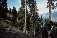
Title (German)
Chur GR, Im oberen Teil des Schwarzwaldes, auf dem Grat
Caption
Structure of high shrub spruce-fir forest (spruce, fir), partially wetted areas, general view, across slope; coordinates (LV03) of camera location: 758150/188600; keywords Documenta Natura: mountain forest, thinning, reforestation, landslide obstruction clearing, road construction.
Caption (German)
Struktur des Hochstauden-Fichten-Tannenwaldes (Fichte, Tanne), teilweise vernässten Stellen, Gesamtansicht, quer zum Hang; Koordinaten (LV03) des Kamerastandorts: 758150/188600; Schlagworte Documenta Natura: Gebirgswald, Durchforstung, Aufforstung, Rutschverbauung Entwaesserung, Strassenbau
Record Name
Dia_303-23104

Title (German)
Chur GR, Im oberen Teil des Schwarzwaldes, auf dem Grat
Caption
Structure of high shrub spruce-fir forest (spruce, fir), partially wetted areas, partial view, across slope; coordinates (LV03) of camera location: 758150/188600; keywords Documenta Natura: mountain forest, thinning, reforestation, landslide obstruction clearing, road construction.
Caption (German)
Struktur des Hochstauden-Fichten-Tannenwaldes (Fichte, Tanne), teilweise vernässten Stellen, Teilansicht, quer zum Hang; Koordinaten (LV03) des Kamerastandorts: 758150/188600; Schlagworte Documenta Natura: Gebirgswald, Durchforstung, Aufforstung, Rutschverbauung Entwaesserung, Strassenbau
Record Name
Dia_303-23107

Title (German)
Chur GR, Im oberen Teil des Schwarzwaldes, auf dem Grat
Caption
Structure of high shrub spruce-fir forest (spruce, fir), partially wetted areas, general view, upslope; coordinates (LV03) of camera location: 758150/188600; keywords Documenta Natura: mountain forest, thinning, reforestation, landslide obstruction clearing, road construction.
Caption (German)
Struktur des Hochstauden-Fichten-Tannenwaldes (Fichte, Tanne), teilweise vernässten Stellen, Gesamtansicht, hangaufwärts; Koordinaten (LV03) des Kamerastandorts: 758150/188600; Schlagworte Documenta Natura: Gebirgswald, Durchforstung, Aufforstung, Rutschverbauung Entwaesserung, Strassenbau
Record Name
Dia_303-23111

Title (German)
Chur GR, Im oberen Teil des Schwarzwaldes, auf dem Grat
Caption
Structure of high shrub spruce-fir forest (spruce, fir), with soil erosion, landslides, partial view, across slope; coordinates (LV03) of camera location: 758400/188650; keywords Documenta Natura: mountain forest, thinning, reforestation, landslide obstruction drainage, road construction.
Caption (German)
Struktur des Hochstauden-Fichten-Tannenwaldes (Fichte, Tanne), mit Bodenerosion, Rutschungen, Teilansicht, quer zum Hang; Koordinaten (LV03) des Kamerastandorts: 758400/188650; Schlagworte Documenta Natura: Gebirgswald, Durchforstung, Aufforstung, Rutschverbauung Entwaesserung, Strassenbau
Record Name
Dia_303-23114

Title (German)
Chur GR, Im oberen Teil des Schwarzwaldes, auf dem Grat
Caption
Structure of high shrub spruce-fir forest (spruce, fir), with soil erosion, landslides, partial view, across slope; coordinates (LV03) of camera location: 758400/188650; keywords Documenta Natura: mountain forest, thinning, reforestation, landslide obstruction drainage, road construction.
Caption (German)
Struktur des Hochstauden-Fichten-Tannenwaldes (Fichte, Tanne), mit Bodenerosion, Rutschungen, Teilansicht, quer zum Hang; Koordinaten (LV03) des Kamerastandorts: 758400/188650; Schlagworte Documenta Natura: Gebirgswald, Durchforstung, Aufforstung, Rutschverbauung Entwaesserung, Strassenbau
Record Name
Dia_303-23117

Title (German)
Chur GR, Im oberen Teil des Schwarzwaldes, auf dem Grat
Caption
Structure of the high shrub spruce-fir forest (spruce, fir), view into a ravine with wet spots, general view, across the slope; coordinates (LV03) of the camera location: 758100/188750; keywords Documenta Natura: mountain forest, thinning, reforestation, landslide obstruction drainage, road construction.
Caption (German)
Struktur des Hochstauden-Fichten-Tannenwaldes (Fichte, Tanne), Blick in ein Tobel mit vernässten Stellen, Gesamtansicht, quer zum Hang; Koordinaten (LV03) des Kamerastandorts: 758100/188750; Schlagworte Documenta Natura: Gebirgswald, Durchforstung, Aufforstung, Rutschverbauung Entwaesserung, Strassenbau
Record Name
Dia_303-23120

Title (German)
Chur GR, Im oberen Teil des Schwarzwaldes, auf dem Grat
Caption
Structure of high shrub spruce-fir forest (spruce, fir), with soil erosion, landslides and wetted areas, partial view, across slope; coordinates (LV03) of camera location: 758200/188750; keywords Documenta Natura: mountain forest, thinning, reforestation, landslide obstruction drainage, road construction.
Caption (German)
Struktur des Hochstauden-Fichten-Tannenwaldes (Fichte, Tanne), mit Bodenerosion, Rutschungen und vernässten Stellen, Teilansicht, quer zum Hang; Koordinaten (LV03) des Kamerastandorts: 758200/188750; Schlagworte Documenta Natura: Gebirgswald, Durchforstung, Aufforstung, Rutschverbauung Entwaesserung, Strassenbau
Record Name
Dia_303-23123

Title (German)
Chur GR, Im oberen Teil des Schwarzwaldes, auf dem Grat
Caption
Structure of high shrub spruce-fir forest (spruce, fir), trees slightly depressed by soil erosion and landslides, partial view, across slope; coordinates (LV03) of camera location: 758350/188850; keywords Documenta Natura: mountain forest, thinning, reforestation, landslide deforestation drainage, road construction.
Caption (German)
Struktur des Hochstauden-Fichten-Tannenwaldes (Fichte, Tanne), durch Bodenerosion und Rutschungen leicht gedrückte Bäume, Teilansicht, quer zum Hang; Koordinaten (LV03) des Kamerastandorts: 758350/188850; Schlagworte Documenta Natura: Gebirgswald, Durchforstung, Aufforstung, Rutschverbauung Entwaesserung, Strassenbau
Record Name
Dia_303-23124

Title (German)
Chur GR, Im oberen Teil des Schwarzwaldes, auf dem Grat
Caption
Structure of high shrub spruce-fir forest (spruce, fir), forest path on dry stone wall, partial view, across slope; coordinates (LV03) of camera location: 758750/189350; keywords Documenta Natura: mountain forest, thinning, reforestation, landslide deforestation, road construction.
Caption (German)
Struktur des Hochstauden-Fichten-Tannenwaldes (Fichte, Tanne), Waldweg auf Trockenmauer, Teilansicht, quer zum Hang; Koordinaten (LV03) des Kamerastandorts: 758750/189350; Schlagworte Documenta Natura: Gebirgswald, Durchforstung, Aufforstung, Rutschverbauung Entwaesserung, Strassenbau
Record Name
Dia_303-23127

Title (German)
Chur GR, Im oberen Teil des Schwarzwaldes, auf dem Grat
Caption
Structure of high shrub spruce-fir forest (spruce, fir), soil erosion, landslides and wetted areas, partial view, downslope; coordinates (LV03) of camera location: 758750/189350; keywords Documenta Natura: mountain forest, thinning, reforestation, landslide obstruction drainage, road construction.
Caption (German)
Struktur des Hochstauden-Fichten-Tannenwaldes (Fichte, Tanne), Bodenerosion, Rutschungen und vernässten Stellen, Teilansicht, hangabwärts; Koordinaten (LV03) des Kamerastandorts: 758750/189350; Schlagworte Documenta Natura: Gebirgswald, Durchforstung, Aufforstung, Rutschverbauung Entwaesserung, Strassenbau
Record Name
Dia_303-23130
Title (German)
Chur GR, Im oberen Teil des Schwarzwaldes, auf dem Grat
Caption
Structure of high shrub spruce-fir forest (overaged spruce, fir), with soil erosion, landslides and wetted areas, partial view, across slope; keywords Documenta Natura: mountain forest, thinning, reforestation, landslide obstruction drainage, road construction.
Caption (German)
Struktur des Hochstauden-Fichten-Tannenwaldes (überalterte Fichte, Tanne), mit Bodenerosion, Rutschungen und vernässten Stellen, Teilansicht, quer zum Hang; Schlagworte Documenta Natura: Gebirgswald, Durchforstung, Aufforstung, Rutschverbauung Entwaesserung, Strassenbau
Record Name
Dia_303-23135

Title (German)
Chur GR, Im oberen Teil des Schwarzwaldes, auf dem Grat
Caption
Structure of the high shrub-spruce-fir forest, with soil erosion, landslides and wetted areas, partial view, transverse to the slope; keywords Documenta Natura: mountain forest, thinning, reforestation, landslide obstruction drainage, road construction.
Caption (German)
Struktur des Hochstauden-Fichten-Tannenwaldes, mit Bodenerosion, Rutschungen und vernässten Stellen, Teilansicht, quer zum Hang; Schlagworte Documenta Natura: Gebirgswald, Durchforstung, Aufforstung, Rutschverbauung Entwaesserung, Strassenbau
Record Name
Dia_303-23139

Title (German)
Chur GR, Im oberen Teil des Schwarzwaldes, auf dem Grat
Caption
Structure of the high shrub spruce-fir forest (spruce, fir), photograph taken in 1990, partial view, downslope; coordinates (LV03) of camera location: 758600/188950; keywords Documenta Natura: mountain forest, thinning, reforestation, landslide obstruction drainage, road construction.
Caption (German)
Struktur des Hochstauden-Fichten-Tannenwaldes (Fichte, Tanne), Aufnahme 1990, Teilansicht, hangabwärts; Koordinaten (LV03) des Kamerastandorts: 758600/188950; Schlagworte Documenta Natura: Gebirgswald, Durchforstung, Aufforstung, Rutschverbauung Entwaesserung, Strassenbau
Record Name
Dia_303-23142

Title (German)
Chur GR, Im oberen Teil des Schwarzwaldes, auf dem Grat
Caption
Structure of the high shrub spruce-fir forest (spruce, fir), photograph taken in 1990, partial view, downslope; coordinates (LV03) of camera location: 758600/188950; keywords Documenta Natura: mountain forest, thinning, reforestation, landslide obstruction drainage, road construction.
Caption (German)
Struktur des Hochstauden-Fichten-Tannenwaldes (Fichte, Tanne), Aufnahme 1990, Teilansicht, hangabwärts; Koordinaten (LV03) des Kamerastandorts: 758600/188950; Schlagworte Documenta Natura: Gebirgswald, Durchforstung, Aufforstung, Rutschverbauung Entwaesserung, Strassenbau
Record Name
Dia_303-23144
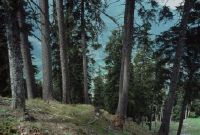
Title (German)
Chur GR, Im oberen Teil des Schwarzwaldes, auf dem Grat
Caption
Structure of the high shrub spruce-fir forest (spruce, fir), photograph taken in 1990, partial view, downslope; coordinates (LV03) of camera location: 758600/188950; keywords Documenta Natura: mountain forest, thinning, reforestation, landslide obstruction drainage, road construction.
Caption (German)
Struktur des Hochstauden-Fichten-Tannenwaldes (Fichte, Tanne), Aufnahme 1990, Teilansicht, hangabwärts; Koordinaten (LV03) des Kamerastandorts: 758600/188950; Schlagworte Documenta Natura: Gebirgswald, Durchforstung, Aufforstung, Rutschverbauung Entwaesserung, Strassenbau
Record Name
Dia_303-23147

Title (German)
Chur GR, Im oberen Teil des Schwarzwaldes, auf dem Grat
Caption
Structure of the high shrub spruce-fir forest (spruce, fir), partially soaked areas, Chur weapons site on the valley floor, photograph taken in 1990, partial view, downslope; coordinates (LV03) of camera location: 758400/189350; keywords Documenta Natura: mountain forest, thinning, reforestation, landslide obstruction drainage, road construction.
Caption (German)
Struktur des Hochstauden-Fichten-Tannenwaldes (Fichte, Tanne), teilweise durchnässte Stellen, Waffenplatz Chur im Talboden, Aufnahme 1990, Teilansicht, hangabwärts; Koordinaten (LV03) des Kamerastandorts: 758400/189350; Schlagworte Documenta Natura: Gebirgswald, Durchforstung, Aufforstung, Rutschverbauung Entwaesserung, Strassenbau
Record Name
Dia_303-23151

Title (German)
Chur GR, Im oberen Teil des Schwarzwaldes, auf dem Grat
Caption
Structure of high shrub spruce-fir forest (spruce, fir), sodden slope side with little planting, photograph taken in 1990, partial view, downslope; coordinates (LV03) of camera location: 758500/189050; keywords Documenta Natura: mountain forest, thinning, reforestation, landslide obstruction drainage, road construction.
Caption (German)
Struktur des Hochstauden-Fichten-Tannenwaldes (Fichte, Tanne), durchnässte Hangseite mit geringer Bepflanzung, Aufnahme 1990, Teilansicht, hangabwärts; Koordinaten (LV03) des Kamerastandorts: 758500/189050; Schlagworte Documenta Natura: Gebirgswald, Durchforstung, Aufforstung, Rutschverbauung Entwaesserung, Strassenbau
Record Name
Dia_303-23153

Title (German)
Chur GR, Im oberen Teil des Schwarzwaldes, auf dem Grat
Caption
Structure of high shrub spruce-fir forest (spruce, fir), sodden slope side with little planting, photograph taken in 1990, partial view, downslope; coordinates (LV03) of camera location: 758500/189050; keywords Documenta Natura: mountain forest, thinning, reforestation, landslide obstruction drainage, road construction.
Caption (German)
Struktur des Hochstauden-Fichten-Tannenwaldes (Fichte, Tanne), durchnässte Hangseite mit geringer Bepflanzung, Aufnahme 1990, Teilansicht, hangabwärts; Koordinaten (LV03) des Kamerastandorts: 758500/189050; Schlagworte Documenta Natura: Gebirgswald, Durchforstung, Aufforstung, Rutschverbauung Entwaesserung, Strassenbau
Record Name
Dia_303-23156

Title (German)
Chur GR, Im oberen Teil des Schwarzwaldes, auf dem Grat
Caption
Structure of high shrub spruce-fir forest (spruce, fir), sodden slope side with little planting, photograph taken in 1990, partial view, downslope; coordinates (LV03) of camera location: 758500/189050; keywords Documenta Natura: mountain forest, thinning, reforestation, landslide obstruction drainage, road construction.
Caption (German)
Struktur des Hochstauden-Fichten-Tannenwaldes (Fichte, Tanne), durchnässte Hangseite mit geringer Bepflanzung, Aufnahme 1990, Teilansicht, hangabwärts; Koordinaten (LV03) des Kamerastandorts: 758500/189050; Schlagworte Documenta Natura: Gebirgswald, Durchforstung, Aufforstung, Rutschverbauung Entwaesserung, Strassenbau
Record Name
Dia_303-23159

Title (German)
Chur GR, Im oberen Teil des Schwarzwaldes, auf dem Grat
Caption
Structure of high shrub spruce-fir forest (spruce, fir), natural regeneration with browsing damage, photograph taken in 1992, partial view, downslope; coordinates (LV03) of camera location: 758775/189200; keywords Documenta Natura: mountain forest, thinning, reforestation, landslide deforestation, road construction.
Caption (German)
Struktur des Hochstauden-Fichten-Tannenwaldes (Fichte, Tanne), natürliche Verjüngung mit Verbissschäden, Aufnahme 1992, Teilansicht, hangabwärts; Koordinaten (LV03) des Kamerastandorts: 758775/189200; Schlagworte Documenta Natura: Gebirgswald, Durchforstung, Aufforstung, Rutschverbauung Entwaesserung, Strassenbau
Record Name
Dia_303-23161

Title (German)
Chur GR, Im oberen Teil des Schwarzwaldes, auf dem Grat
Caption
Structure of high shrub spruce-fir forest (spruce, fir), with sodden patches, photograph taken in 1992, partial view, downslope; coordinates (LV03) of camera location: 758775/189200; keywords Documenta Natura: mountain forest, thinning, reforestation, landslide obstruction drainage, road construction.
Caption (German)
Struktur des Hochstauden-Fichten-Tannenwaldes (Fichte, Tanne), mit durchnässten Stellen, Aufnahme 1992, Teilansicht, hangabwärts; Koordinaten (LV03) des Kamerastandorts: 758775/189200; Schlagworte Documenta Natura: Gebirgswald, Durchforstung, Aufforstung, Rutschverbauung Entwaesserung, Strassenbau
Record Name
Dia_303-23163

Title (German)
Chur GR, Im oberen Teil des Schwarzwaldes, auf dem Grat
Caption
Structure of high shrub spruce-fir forest (spruce, fir), top of slope, natural regeneration with browsing damage, photograph taken in 1992, partial view, across slope, downslope; coordinates (LV03) of camera location: 758775/189200; keywords Documenta Natura: mountain forest, thinning, reforestation, landslide deforestation, road construction.
Caption (German)
Struktur des Hochstauden-Fichten-Tannenwaldes (Fichte, Tanne), Hangoberkante, natürliche Verjüngung mit Verbissschäden, Aufnahme 1992, Teilansicht, quer zum Hang, hangabwärts; Koordinaten (LV03) des Kamerastandorts: 758775/189200; Schlagworte Documenta Natura: Gebirgswald, Durchforstung, Aufforstung, Rutschverbauung Entwaesserung, Strassenbau
Record Name
Dia_303-23167

Title (German)
Chur GR, Im oberen Teil des Schwarzwaldes, auf dem Grat
Caption
Structure of the high shrub spruce-fir forest (spruce, fir), photograph taken in 1992, partial view, downslope; coordinates (LV03) of camera location: 758775/189200; keywords Documenta Natura: mountain forest, thinning, reforestation, landslide obstruction drainage, road construction.
Caption (German)
Struktur des Hochstauden-Fichten-Tannenwaldes (Fichte, Tanne), Aufnahme 1992, Teilansicht, hangabwärts; Koordinaten (LV03) des Kamerastandorts: 758775/189200; Schlagworte Documenta Natura: Gebirgswald, Durchforstung, Aufforstung, Rutschverbauung Entwaesserung, Strassenbau
Record Name
Dia_303-23169

Title (German)
Chur GR, Im oberen Teil des Schwarzwaldes, auf dem Grat
Caption
Structure of the high shrub spruce-fir forest (spruce, fir), photograph taken in 1992, partial view, downslope; coordinates (LV03) of camera location: 758775/189200; keywords Documenta Natura: mountain forest, thinning, reforestation, landslide obstruction drainage, road construction.
Caption (German)
Struktur des Hochstauden-Fichten-Tannenwaldes (Fichte, Tanne), Aufnahme 1992, Teilansicht, hangabwärts; Koordinaten (LV03) des Kamerastandorts: 758775/189200; Schlagworte Documenta Natura: Gebirgswald, Durchforstung, Aufforstung, Rutschverbauung Entwaesserung, Strassenbau
Record Name
Dia_303-23173

Title (German)
Chur GR, Im oberen Teil des Schwarzwaldes, auf dem Grat
Caption
Structure of the high shrub spruce-fir forest (spruce, fir), photograph taken in 1992, partial view, downslope; coordinates (LV03) of camera location: 758775/189200; keywords Documenta Natura: mountain forest, thinning, reforestation, landslide obstruction drainage, road construction.
Caption (German)
Struktur des Hochstauden-Fichten-Tannenwaldes (Fichte, Tanne), Aufnahme 1992, Teilansicht, hangabwärts; Koordinaten (LV03) des Kamerastandorts: 758775/189200; Schlagworte Documenta Natura: Gebirgswald, Durchforstung, Aufforstung, Rutschverbauung Entwaesserung, Strassenbau
Record Name
Dia_303-23176
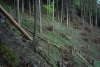
Title (German)
Chur GR, Im Schwarzwald, ca. 200 m westlich des Känzeli
Caption
Bare, wooded forest area with game fence, photograph taken in spring 1990, partial view across the slope; coordinates (LV03) of camera location: 758900/189600; keywords Documenta Natura: mountain forest, thinning, reforestation, landslide deforestation, road construction
Caption (German)
Kahle, geholzte Waldfläche mit Wildschutzzaun, Aufnahme Frühling 1990, Teilansicht quer zum Hang; Koordinaten (LV03) des Kamerastandorts: 758900/189600; Schlagworte Documenta Natura: Gebirgswald, Durchforstung, Aufforstung, Rutschverbauung Entwaesserung, Strassenbau
Record Name
Dia_303-23178

Title (German)
Chur GR, Im Schwarzwald, ca. 200 m westlich des Känzeli
Caption
Bare, wooded forest area with game fence, photograph taken in spring 1990, partial view across the slope; coordinates (LV03) of camera location: 758900/189600; keywords Documenta Natura: mountain forest, thinning, reforestation, landslide deforestation, road construction
Caption (German)
Kahle, geholzte Waldfläche mit Wildschutzzaun, Aufnahme Frühling 1990, Teilansicht quer zum Hang; Koordinaten (LV03) des Kamerastandorts: 758900/189600; Schlagworte Documenta Natura: Gebirgswald, Durchforstung, Aufforstung, Rutschverbauung Entwaesserung, Strassenbau
Record Name
Dia_303-23181

Title (German)
Chur GR, Im Schwarzwald, ca. 200 m westlich des Känzeli
Caption
Bare, wooded forest area with game fence, photograph taken in spring 1990, partial view across the slope; coordinates (LV03) of camera location: 758900/189600; keywords Documenta Natura: mountain forest, thinning, reforestation, landslide deforestation, road construction
Caption (German)
Kahle, geholzte Waldfläche mit Wildschutzzaun, Aufnahme Frühling 1990, Teilansicht quer zum Hang; Koordinaten (LV03) des Kamerastandorts: 758900/189600; Schlagworte Documenta Natura: Gebirgswald, Durchforstung, Aufforstung, Rutschverbauung Entwaesserung, Strassenbau
Record Name
Dia_303-23185

Title (German)
Chur GR, Im Schwarzwald, ca. 200 m westlich des Känzeli
Caption
Bare, wooded forest area with game fence, photograph taken in spring 1990, partial view downslope; coordinates (LV03) of camera location: 758900/189600; keywords Documenta Natura: mountain forest, thinning, reforestation, landslide obstruction drainage, road construction.
Caption (German)
Kahle, geholzte Waldfläche mit Wildschutzzaun, Aufnahme Frühling 1990, Teilansicht hangabwärts; Koordinaten (LV03) des Kamerastandorts: 758900/189600; Schlagworte Documenta Natura: Gebirgswald, Durchforstung, Aufforstung, Rutschverbauung Entwaesserung, Strassenbau
Record Name
Dia_303-23187

Title (German)
Chur GR, Im Schwarzwald, ca. 200 m westlich des Känzeli
Caption
Fenced forest area with reforestation, photo spring 1992, partial view across the slope; coordinates (LV03) of camera location: 758900/189600; keywords Documenta Natura: mountain forest, thinning, reforestation, landslide deforestation, road construction
Caption (German)
Eingezäunte Waldfläche mit Aufforstung, Aufnahme Frühling 1992, Teilansicht quer zum Hang; Koordinaten (LV03) des Kamerastandorts: 758900/189600; Schlagworte Documenta Natura: Gebirgswald, Durchforstung, Aufforstung, Rutschverbauung Entwaesserung, Strassenbau
Record Name
Dia_303-23191

Title (German)
Chur GR, Im Schwarzwald, ca. 200 m westlich des Känzeli
Caption
Fenced forest area with reforestation, photo spring 1992, partial view across the slope; coordinates (LV03) of the camera location: 758900/189600; keywords Documenta Natura: mountain forest, thinning, reforestation, landslide deforestation, road construction
Caption (German)
Eingezäunte Waldfläche mit Aufforstung, Aufnahme Frühling 1992, Teilansicht quer zum Hang; Koordinaten (LV03) des Kamerastandorts: 758900/189600; Schlagworte Documenta Natura: Gebirgswald, Durchforstung, Aufforstung, Rutschverbauung Entwaesserung, Strassenbau
Record Name
Dia_303-23193

Title (German)
Chur GR, Im Schwarzwald, ca. 200 m westlich des Känzeli
Caption
Fenced forest area with reforestation, photo spring 1992, partial view across the slope; coordinates (LV03) of camera location: 758900/189600; keywords Documenta Natura: mountain forest, thinning, reforestation, landslide deforestation, road construction
Caption (German)
Eingezäunte Waldfläche mit Aufforstung, Aufnahme Frühling 1992, Teilansicht quer zum Hang; Koordinaten (LV03) des Kamerastandorts: 758900/189600; Schlagworte Documenta Natura: Gebirgswald, Durchforstung, Aufforstung, Rutschverbauung Entwaesserung, Strassenbau
Record Name
Dia_303-23196

Title (German)
Chur GR, Im Schwarzwald
Caption
Browsing damage to young spruce, partially with protective coating (white paint), snow-covered, partial view; Keywords Documenta Natura: mountain forest, thinning, reforestation, landslide deforestation, road construction.
Caption (German)
Verbissschäden an jungen Fichten, teilweise mit Schutzanstrich (weisse Farbe), schneebedeckt, Teilansicht; Schlagworte Documenta Natura: Gebirgswald, Durchforstung, Aufforstung, Rutschverbauung Entwaesserung, Strassenbau
Record Name
Dia_303-23202

Title (German)
Chur GR, Im Schwarzwald
Caption
Browsing damage to young spruce, snow-covered, partial view; Keywords Documenta Natura: mountain forest, thinning, reforestation, landslide deforestation, road construction.
Caption (German)
Verbissschäden an junger Fichte, schneebedeckt, Teilansicht; Schlagworte Documenta Natura: Gebirgswald, Durchforstung, Aufforstung, Rutschverbauung Entwaesserung, Strassenbau
Record Name
Dia_303-23205
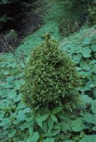
Title (German)
Chur GR, Im Schwarzwald
Caption
Browsing damage to young spruce, during vegetation phase, partial view; coordinates (LV03) of camera location: 757950/189150; keywords Documenta Natura: mountain forest, thinning, reforestation, landslide deforestation, road construction.
Caption (German)
Verbissschäden an junger Fichte, während der Vegetationsphase, Teilansicht; Koordinaten (LV03) des Kamerastandorts: 757950/189150; Schlagworte Documenta Natura: Gebirgswald, Durchforstung, Aufforstung, Rutschverbauung Entwaesserung, Strassenbau
Record Name
Dia_303-23208

Title (German)
Chur GR, Im Schwarzwald
Caption
Browsing damage to young spruce, during vegetation phase, partial view; coordinates (LV03) of camera location: 757950/189150; keywords Documenta Natura: mountain forest, thinning, reforestation, landslide deforestation, road construction.
Caption (German)
Verbissschäden an junger Fichte, während der Vegetationsphase, Teilansicht; Koordinaten (LV03) des Kamerastandorts: 757950/189150; Schlagworte Documenta Natura: Gebirgswald, Durchforstung, Aufforstung, Rutschverbauung Entwaesserung, Strassenbau
Record Name
Dia_303-23214

Title (German)
Chur GR, Im Schwarzwald
Caption
Browsing damage to young spruce trees, photograph taken in autumn (first snow on the ground), partial view; coordinates (LV03) of camera location: 757950/188850; keywords Documenta Natura: mountain forest, thinning, reforestation, landslide deforestation, road construction.
Caption (German)
Verbissschäden an jungen Fichten, Aufnahme im Herbst (erster Schnee am Boden), Teilansicht; Koordinaten (LV03) des Kamerastandorts: 757950/188850; Schlagworte Documenta Natura: Gebirgswald, Durchforstung, Aufforstung, Rutschverbauung Entwaesserung, Strassenbau
Record Name
Dia_303-23220

Title (German)
Chur GR, Im Schwarzwald
Caption
Browsing damage to young spruce trees, structure mountain forest, photograph taken in autumn (first snow lies on the ground), general view; coordinates (LV03) of camera location: 757950/188850; keywords Documenta Natura: mountain forest, thinning, reforestation, landslide deforestation, road construction
Caption (German)
Verbissschäden an jungen Fichten, Struktur Gebirgswald, Aufnahme im Herbst (erster Schnee liegt am Boden), Gesamtansicht; Koordinaten (LV03) des Kamerastandorts: 757950/188850; Schlagworte Documenta Natura: Gebirgswald, Durchforstung, Aufforstung, Rutschverbauung Entwaesserung, Strassenbau
Record Name
Dia_303-23223

Title (German)
Chur GR, Im Schwarzwald
Caption
Landslide area in forest covered with gray alpendost (Adenostyles alliariae), in between young browsed spruce trees, general view; coordinates (LV03) of camera location: 758600/189100; keywords Documenta Natura: mountain forest, thinning, reforestation, landslide deforestation, road construction
Caption (German)
Rutschfläche im Wald bedeckt mit Grauer Alpendost (Adenostyles alliariae), dazwischen junge, verbissenen Fichten, Gesamtansicht; Koordinaten (LV03) des Kamerastandorts: 758600/189100; Schlagworte Documenta Natura: Gebirgswald, Durchforstung, Aufforstung, Rutschverbauung Entwaesserung, Strassenbau
Record Name
Dia_303-23227

Title (German)
Chur GR, Im Schwarzwald
Caption
Landslide area in forest covered with gray alpendost (Adenostyles alliariae), alders planted in between, partial view; coordinates (LV03) of camera location: 758600/189100; keywords Documenta Natura: mountain forest, thinning, reforestation, landslide deforestation, road construction
Caption (German)
Rutschfläche im Wald bedeckt mit Grauer Alpendost (Adenostyles alliariae), dazwischen gepflanzte Erlen, Teilansicht; Koordinaten (LV03) des Kamerastandorts: 758600/189100; Schlagworte Documenta Natura: Gebirgswald, Durchforstung, Aufforstung, Rutschverbauung Entwaesserung, Strassenbau
Record Name
Dia_303-23229

Title (German)
Chur GR, Im Schwarzwald
Caption
Landslide area in forest covered with gray alpendost (Adenostyles alliariae), in between young browsed spruce, detail view; coordinates (LV03) of camera location: 758600/189100; keywords Documenta Natura: mountain forest, thinning, reforestation, landslide deforestation, road construction
Caption (German)
Rutschfläche im Wald bedeckt mit Grauer Alpendost (Adenostyles alliariae), dazwischen junge, verbissene Fichte, Detailansicht; Koordinaten (LV03) des Kamerastandorts: 758600/189100; Schlagworte Documenta Natura: Gebirgswald, Durchforstung, Aufforstung, Rutschverbauung Entwaesserung, Strassenbau
Record Name
Dia_303-23231

Title (German)
Chur GR, Im Schwarzwald
Caption
Landslide area in forest covered with gray alpendost (Adenostyles alliariae), general view; coordinates (LV03) of camera location: 758600/189100; keywords Documenta Natura: mountain forest, thinning, reforestation, landslide deforestation, road construction
Caption (German)
Rutschfläche im Wald bedeckt mit Grauer Alpendost (Adenostyles alliariae), Gesamtansicht; Koordinaten (LV03) des Kamerastandorts: 758600/189100; Schlagworte Documenta Natura: Gebirgswald, Durchforstung, Aufforstung, Rutschverbauung Entwaesserung, Strassenbau
Record Name
Dia_303-23235
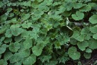
Title (German)
Chur GR, Im Schwarzwald
Caption
Landslide area in forest covered with gray alpendost (Adenostyles alliariae), detailed view; coordinates (LV03) of camera location: 758600/189100; keywords Documenta Natura: mountain forest, thinning, reforestation, landslide deforestation, road construction
Caption (German)
Rutschfläche im Wald bedeckt mit Grauer Alpendost (Adenostyles alliariae), Detailansicht; Koordinaten (LV03) des Kamerastandorts: 758600/189100; Schlagworte Documenta Natura: Gebirgswald, Durchforstung, Aufforstung, Rutschverbauung Entwaesserung, Strassenbau
Record Name
Dia_303-23237

Title (German)
Chur GR, Im Schwarzwald
Caption
Landslide area in forest covered with gray alpendost (Adenostyles alliariae), partial view; coordinates (LV03) of camera location: 758600/189100; keywords Documenta Natura: mountain forest, thinning, reforestation, landslide deforestation, road construction
Caption (German)
Rutschfläche im Wald bedeckt mit Grauer Alpendost (Adenostyles alliariae), Teilansicht; Koordinaten (LV03) des Kamerastandorts: 758600/189100; Schlagworte Documenta Natura: Gebirgswald, Durchforstung, Aufforstung, Rutschverbauung Entwaesserung, Strassenbau
Record Name
Dia_303-23239
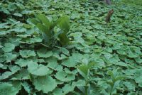
Title (German)
Chur GR, Im Schwarzwald
Caption
Landslide area in forest covered with gray alpendost (Adenostyles alliariae), partial view; coordinates (LV03) of camera location: 758600/189100; keywords Documenta Natura: mountain forest, thinning, reforestation, landslide deforestation, road construction
Caption (German)
Rutschfläche im Wald bedeckt mit Grauer Alpendost (Adenostyles alliariae), Teilansicht; Koordinaten (LV03) des Kamerastandorts: 758600/189100; Schlagworte Documenta Natura: Gebirgswald, Durchforstung, Aufforstung, Rutschverbauung Entwaesserung, Strassenbau
Record Name
Dia_303-23242

Title (German)
Chur GR, Im Schwarzwald
Caption
Excavation of trenches in steep forest slope with the help of a walking excavator, partial view; coordinates (LV03) of camera location: 758500/189000; keywords Documenta Natura: mountain forest, thinning, reforestation, landslide deforestation, road construction
Caption (German)
Ausheben von Gräben im steilen Waldhang mit Hilfe eines Schreitbaggers, Teilansicht; Koordinaten (LV03) des Kamerastandorts: 758500/189000; Schlagworte Documenta Natura: Gebirgswald, Durchforstung, Aufforstung, Rutschverbauung Entwaesserung, Strassenbau
Record Name
Dia_303-23245

Title (German)
Chur GR, Im Schwarzwald
Caption
Excavation of trenches in steep forest slope with the help of a walking excavator, partial view; coordinates (LV03) of camera location: 758500/189000; keywords Documenta Natura: mountain forest, thinning, reforestation, landslide deforestation, road construction
Caption (German)
Ausheben von Gräben im steilen Waldhang mit Hilfe eines Schreitbaggers, Teilansicht; Koordinaten (LV03) des Kamerastandorts: 758500/189000; Schlagworte Documenta Natura: Gebirgswald, Durchforstung, Aufforstung, Rutschverbauung Entwaesserung, Strassenbau
Record Name
Dia_303-23247

Title (German)
Chur GR, Im Schwarzwald
Caption
Excavation of trenches in steep forest slope with the help of a walking excavator, partial view; coordinates (LV03) of camera location: 758500/189000; keywords Documenta Natura: mountain forest, thinning, reforestation, landslide deforestation, road construction
Caption (German)
Ausheben von Gräben im steilen Waldhang mit Hilfe eines Schreitbaggers, Teilansicht; Koordinaten (LV03) des Kamerastandorts: 758500/189000; Schlagworte Documenta Natura: Gebirgswald, Durchforstung, Aufforstung, Rutschverbauung Entwaesserung, Strassenbau
Record Name
Dia_303-23249

Title (German)
Chur GR, Im Schwarzwald
Caption
Excavation of trenches in steep forest slope with the help of a walking excavator, partial view; coordinates (LV03) of camera location: 758500/189000; keywords Documenta Natura: mountain forest, thinning, reforestation, landslide deforestation, road construction
Caption (German)
Ausheben von Gräben im steilen Waldhang mit Hilfe eines Schreitbaggers, Teilansicht; Koordinaten (LV03) des Kamerastandorts: 758500/189000; Schlagworte Documenta Natura: Gebirgswald, Durchforstung, Aufforstung, Rutschverbauung Entwaesserung, Strassenbau
Record Name
Dia_303-23252

Title (German)
Chur GR, Im Schwarzwald
Caption
Excavation of trenches in steep forest slope with the help of a walking excavator, general view; coordinates (LV03) of camera location: 758500/189000; keywords Documenta Natura: mountain forest, thinning, reforestation, landslide deforestation, road construction
Caption (German)
Ausheben von Gräben im steilen Waldhang mit Hilfe eines Schreitbaggers, Gesamtansicht; Koordinaten (LV03) des Kamerastandorts: 758500/189000; Schlagworte Documenta Natura: Gebirgswald, Durchforstung, Aufforstung, Rutschverbauung Entwaesserung, Strassenbau
Record Name
Dia_303-23255

Title (German)
Flims GR, Beim Weg nördlich der Höhenkote Aut la Runca
Caption
Flight helper latching the prepared rotations (=loads) to the transport rope of the helicopter, avalanche defense material; keywords Documenta Natura: avalanche defense, protection forest, reforestation, landslide.
Caption (German)
Flughelfer beim Einklinken der vorbereiteten Rotationen (=Ladungen) an das Transportseil des Helikopters, Lawinenverbauungsmaterial; Schlagworte Documenta Natura: Lawinenverbauung, Schutzwald, Aufforstung, Bergsturz
Record Name
Dia_303-23264

Title (German)
Flims GR, Beim Weg nördlich der Höhenkote Aut la Runca
Caption
Flight helper latching the prepared rotations (=loads) to the transport rope of the helicopter, avalanche defense material; keywords Documenta Natura: avalanche defense, protection forest, reforestation, landslide.
Caption (German)
Flughelfer beim Einklinken der vorbereiteten Rotationen (=Ladungen) an das Transportseil des Helikopters, Lawinenverbauungsmaterial; Schlagworte Documenta Natura: Lawinenverbauung, Schutzwald, Aufforstung, Bergsturz
Record Name
Dia_303-23267

Title (German)
Flims GR, Beim Weg nördlich der Höhenkote Aut la Runca
Caption
Flight helper latching the prepared rotations (=loads) to the transport rope of the helicopter, avalanche defense material; keywords Documenta Natura: avalanche defense, protection forest, reforestation, landslide.
Caption (German)
Flughelfer beim Einklinken der vorbereiteten Rotationen (=Ladungen) an das Transportseil des Helikopters, Lawinenverbauungsmaterial; Schlagworte Documenta Natura: Lawinenverbauung, Schutzwald, Aufforstung, Bergsturz
Record Name
Dia_303-23269

Title (German)
Flims GR, Beim Weg nördlich der Höhenkote Aut la Runca
Caption
Helicopter approaching the loading area with the prepared loads (=rotations), steel elements for avalanche defense, partial view; keywords Documenta Natura: avalanche defense, protection forest, reforestation, landslide
Caption (German)
Helikopter beim Anflug an den Ladeplatz mit den vorbereiteten Ladungen (=Rotationen), Stahlelemente für Lawinenverbauung, Teilansicht; Schlagworte Documenta Natura: Lawinenverbauung, Schutzwald, Aufforstung, Bergsturz
Record Name
Dia_303-23274

Title (German)
Flims GR, Beim Weg nördlich der Höhenkote Aut la Runca
Caption
Flight helper latching the load on the rope from the helicopter, partial view; Keywords Documenta Natura: avalanche defense, protection forest, reforestation, landslide.
Caption (German)
Flughelfer beim Einklinken der Ladung am Seil vom Helikopter, Teilansicht; Schlagworte Documenta Natura: Lawinenverbauung, Schutzwald, Aufforstung, Bergsturz
Record Name
Dia_303-23278
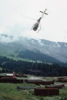
Title (German)
Flims GR, Beim Weg nördlich der Höhenkote Aut la Runca
Caption
Helicopter taking off from the loading area with load (=rotations) on the rope, steel elements for avalanche defense, partial view; keywords Documenta Natura: avalanche defense, protection forest, reforestation, landslide
Caption (German)
Helikopter beim Abflug vom Ladeplatz mit Ladung (=Rotationen) am Seil, Stahlelemente für Lawinenverbauung, Teilansicht; Schlagworte Documenta Natura: Lawinenverbauung, Schutzwald, Aufforstung, Bergsturz
Record Name
Dia_303-23280

Title (German)
Flims GR, Beim Weg nördlich der Höhenkote Aut la Runca
Caption
Flight helper latching the load on the rope from the helicopter, partial view; Keywords Documenta Natura: avalanche defense, protection forest, reforestation, landslide.
Caption (German)
Flughelfer beim Einklinken der Ladung am Seil vom Helikopter, Teilansicht; Schlagworte Documenta Natura: Lawinenverbauung, Schutzwald, Aufforstung, Bergsturz
Record Name
Dia_303-23283

Title (German)
Flims GR, Beim Weg nördlich der Höhenkote Aut la Runca
Caption
Helicopter taking off from the loading area with load (=rotations) on the rope, steel elements for avalanche defense, partial view; keywords Documenta Natura: avalanche defense, protection forest, reforestation, landslide
Caption (German)
Helikopter beim Abflug vom Ladeplatz mit Ladung (=Rotationen) am Seil, Stahlelemente für Lawinenverbauung, Teilansicht; Schlagworte Documenta Natura: Lawinenverbauung, Schutzwald, Aufforstung, Bergsturz
Record Name
Dia_303-23289

Title (German)
Flims GR, Beim Weg nördlich der Höhenkote Aut la Runca
Caption
Helicopter taking off from the loading area with load (=rotations) on the rope, steel elements for avalanche defense, general view; keywords Documenta Natura: avalanche defense, protection forest, reforestation, landslide
Caption (German)
Helikopter beim Abflug vom Ladeplatz mit Ladung (=Rotationen) am Seil, Stahlelemente für Lawinenverbauung, Gesamtansicht; Schlagworte Documenta Natura: Lawinenverbauung, Schutzwald, Aufforstung, Bergsturz
Record Name
Dia_303-23301

Title (German)
Flims GR, Beim Weg nördlich der Höhenkote Aut la Runca
Caption
Helicopter taking off from the loading area with load (=rotations) on the rope, steel elements for avalanche defense, general view; keywords Documenta Natura: avalanche defense, protection forest, reforestation, landslide
Caption (German)
Helikopter beim Abflug vom Ladeplatz mit Ladung (=Rotationen) am Seil, Stahlelemente für Lawinenverbauung, Gesamtansicht; Schlagworte Documenta Natura: Lawinenverbauung, Schutzwald, Aufforstung, Bergsturz
Record Name
Dia_303-23304
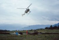
Title (German)
Flims GR, Beim Weg nördlich der Höhenkote Aut la Runca
Caption
Helicopter approaching the loading area with the prepared loads (=rotations), steel elements for avalanche defense, partial view; keywords Documenta Natura: avalanche defense, protection forest, reforestation, landslide
Caption (German)
Helikopter beim Anflug an den Ladeplatz mit den vorbereiteten Ladungen (=Rotationen), Stahlelemente für Lawinenverbauung, Teilansicht; Schlagworte Documenta Natura: Lawinenverbauung, Schutzwald, Aufforstung, Bergsturz
Record Name
Dia_303-23312

Title (German)
Flims GR, Blick (Südansicht) über die Geröllhalde des Bergsturzes oberhalb des Waldes Uaul da Preuls
Caption
South view upslope over the scree of the landslide with boulders and conifers (spruce) lying around, in the background the Flimserstein with the demolition site (1998), partial view, 1st follow-up photograph after 2 years (2000); coordinates (LV03) of the camera location: 7402ff/19077f; keywords Documenta Natura: avalanche defense, protection forest, reforestation, landslide
Caption (German)
Südansicht hangaufwärts über die Geröllhalde des Bergsturzes mit herumliegenden Felsblöcken und Nadelbäumen (Fichte), im Hintergrund der Flimserstein mit der Abrissstelle (1998), Teilansicht, 1. Folgeaufnahme nach 2 Jahren (2000); Koordinaten (LV03) des Kamerastandorts: 7402ff/19077f; Schlagworte Documenta Natura: Lawinenverbauung, Schutzwald, Aufforstung, Bergsturz
Record Name
Dia_303-23325

Title (German)
Flims GR, In Alpweide oberhalb des Weilers Flida
Caption
Water channel caused by erosion, stream bed (currently dry) in steeply sloping alpine pasture, partial view; keywords Documenta Natura: avalanche defense, protection forest, reforestation, landslide.
Caption (German)
Durch Erosion verursachte Wasserrinne, Bachbett (zur Zeit trocken) in steil abfallender Alpweide, Teilansicht; Schlagworte Documenta Natura: Lawinenverbauung, Schutzwald, Aufforstung, Bergsturz
Record Name
Dia_303-23346

Title (German)
Flims GR, In Alpweide oberhalb des Weilers Flida
Caption
Water channel caused by erosion, stream bed (currently dry) in steeply sloping alpine pasture, partial view; keywords Documenta Natura: avalanche defense, protection forest, reforestation, landslide.
Caption (German)
Durch Erosion verursachte Wasserrinne, Bachbett (zur Zeit trocken) in steil abfallender Alpweide, Teilansicht; Schlagworte Documenta Natura: Lawinenverbauung, Schutzwald, Aufforstung, Bergsturz
Record Name
Dia_303-23349

Title (German)
Flims GR, In Alpweide oberhalb des Weilers Flida
Caption
Water channel caused by erosion, stream bed (currently dry) in steeply sloping alpine pasture, partial view; keywords Documenta Natura: avalanche defense, protection forest, reforestation, landslide.
Caption (German)
Durch Erosion verursachte Wasserrinne, Bachbett (zur Zeit trocken) in steil abfallender Alpweide, Teilansicht; Schlagworte Documenta Natura: Lawinenverbauung, Schutzwald, Aufforstung, Bergsturz
Record Name
Dia_303-23352

Title (German)
Flims GR, In Alpweide oberhalb des Weilers Flida
Caption
Water channel caused by erosion, stream bed (currently dry) in steeply sloping alpine pasture, partial view; keywords Documenta Natura: avalanche defense, protection forest, reforestation, landslide.
Caption (German)
Durch Erosion verursachte Wasserrinne, Bachbett (zur Zeit trocken) in steil abfallender Alpweide, Teilansicht; Schlagworte Documenta Natura: Lawinenverbauung, Schutzwald, Aufforstung, Bergsturz
Record Name
Dia_303-23355

Title (German)
Flims GR, In Alpweide oberhalb des Weilers Flida
Caption
Water channel caused by erosion, stream bed (currently dry) in steeply sloping alpine pasture, partial view; keywords Documenta Natura: avalanche defense, protection forest, reforestation, landslide.
Caption (German)
Durch Erosion verursachte Wasserrinne, Bachbett (zur Zeit trocken) in steil abfallender Alpweide, Teilansicht; Schlagworte Documenta Natura: Lawinenverbauung, Schutzwald, Aufforstung, Bergsturz
Record Name
Dia_303-23358

Title (German)
Flims GR, In Alpweide oberhalb des Weilers Flida
Caption
Water channel caused by erosion, stream bed (currently dry) in steeply sloping alpine pasture, partial view; keywords Documenta Natura: avalanche defense, protection forest, reforestation, landslide.
Caption (German)
Durch Erosion verursachte Wasserrinne, Bachbett (zur Zeit trocken) in steil abfallender Alpweide, Teilansicht; Schlagworte Documenta Natura: Lawinenverbauung, Schutzwald, Aufforstung, Bergsturz
Record Name
Dia_303-23364

Title (German)
Flims GR, Im Schutzwald Uaul Preuls
Caption
Forest floor with depressions and rock chips after boulder impact, partial view; Keywords Documenta Natura: avalanche defense, protection forest, reforestation, landslide.
Caption (German)
Waldboden mit Mulden und Felssplittern nach Felsblockaufschlag, Teilansicht; Schlagworte Documenta Natura: Lawinenverbauung, Schutzwald, Aufforstung, Bergsturz
Record Name
Dia_303-23366
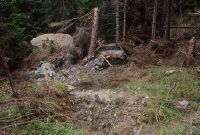
Title (German)
Flims GR, Im Schutzwald Uaul Preuls
Caption
Protective forest with pushed, fallen and splintered spruces, drought wood, depressions and rock splinters after boulder impact, partial view; Keywords Documenta Natura: avalanche defense, protective forest, reforestation, landslide.
Caption (German)
Schutzwald mit gestossenen, umgeworfenen und gesplitterten Fichten, Dürrholz, Mulden und Felssplittern nach Felsblockaufschlag, Teilansicht; Schlagworte Documenta Natura: Lawinenverbauung, Schutzwald, Aufforstung, Bergsturz
Record Name
Dia_303-23370

Title (German)
Flims GR, Im Schutzwald Uaul Preuls
Caption
Captured boulder in protection forest, partial view; Keywords Documenta Natura: avalanche defense, protection forest, reforestation, landslide.
Caption (German)
Aufgefangener Felsblock im Schutzwald, Teilansicht; Schlagworte Documenta Natura: Lawinenverbauung, Schutzwald, Aufforstung, Bergsturz
Record Name
Dia_303-23373

Title (German)
Flims GR, Im Schutzwald Uaul Preuls
Caption
Trapped boulder in protection forest with pushed or fallen spruces, partial view; Keywords Documenta Natura: avalanche defense, protection forest, reforestation, landslide.
Caption (German)
Aufgefangener Felsblock im Schutzwald mit gestossenen oder umgeworfenen Fichten, Teilansicht; Schlagworte Documenta Natura: Lawinenverbauung, Schutzwald, Aufforstung, Bergsturz
Record Name
Dia_303-23376

Title (German)
Flims GR, Im Schutzwald Uaul Preuls
Caption
Trapped boulder in protection forest with pushed, fallen and splintered spruces, partial view; Keywords Documenta Natura: avalanche defense, protection forest, reforestation, landslide.
Caption (German)
Aufgefangener Felsblock im Schutzwald mit gestossenen, umgeworfenen und gesplitterten Fichten, Teilansicht; Schlagworte Documenta Natura: Lawinenverbauung, Schutzwald, Aufforstung, Bergsturz
Record Name
Dia_303-23382
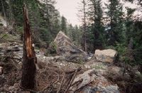
Title (German)
Flims GR, Im Schutzwald Uaul Preuls
Caption
Rocks caught in protection forest with pushed or fallen spruces, Dürrholz, partial view; Keywords Documenta Natura: avalanche defense, protection forest, reforestation, landslide.
Caption (German)
Aufgefangene Felsblöcke im Schutzwald mit gestossenen oder umgeworfenen Fichten, Dürrholz, Teilansicht; Schlagworte Documenta Natura: Lawinenverbauung, Schutzwald, Aufforstung, Bergsturz
Record Name
Dia_303-23387

Title (German)
Flims GR, Im Schutzwald Uaul Preuls
Caption
Trapped boulder in protection forest with pushed, fallen and splintered spruces, partial view; Keywords Documenta Natura: avalanche defense, protection forest, reforestation, landslide.
Caption (German)
Aufgefangener Felsblock im Schutzwald mit gestossenen, umgeworfenen und gesplitterten Fichten, Teilansicht; Schlagworte Documenta Natura: Lawinenverbauung, Schutzwald, Aufforstung, Bergsturz
Record Name
Dia_303-23391

Title (German)
Flims GR, Im Schutzwald Uaul Preuls
Caption
Trapped boulder in protection forest with pushed, fallen and splintered spruces, partial view; Keywords Documenta Natura: avalanche defense, protection forest, reforestation, landslide.
Caption (German)
Aufgefangener Felsblock im Schutzwald mit gestossenen, umgeworfenen und gesplitterten Fichten, Teilansicht; Schlagworte Documenta Natura: Lawinenverbauung, Schutzwald, Aufforstung, Bergsturz
Record Name
Dia_303-23394

Title (German)
Flims GR, Im Schutzwald Uaul Preuls
Caption
Trapped boulder in protection forest with pushed, fallen and splintered spruces, partial view; Keywords Documenta Natura: avalanche defense, protection forest, reforestation, landslide.
Caption (German)
Aufgefangener Felsblock im Schutzwald mit gestossenen, umgeworfenen und gesplitterten Fichten, Teilansicht; Schlagworte Documenta Natura: Lawinenverbauung, Schutzwald, Aufforstung, Bergsturz
Record Name
Dia_303-23397

Title (German)
Flims GR, Im Schutzwald Uaul Preuls
Caption
Trapped boulder in protection forest with pushed spruce, partial view; Keywords Documenta Natura: avalanche defense, protection forest, reforestation, landslide.
Caption (German)
Aufgefangener Felsblock im Schutzwald mit gestossener Fichte, Teilansicht; Schlagworte Documenta Natura: Lawinenverbauung, Schutzwald, Aufforstung, Bergsturz
Record Name
Dia_303-23402

Title (German)
Flims GR, Im Schutzwald Uaul Preuls
Caption
Trapped boulder in protection forest with pushed spruce, partial view; Keywords Documenta Natura: avalanche defense, protection forest, reforestation, landslide.
Caption (German)
Aufgefangener Felsblock im Schutzwald mit gestossener Fichte, Teilansicht; Schlagworte Documenta Natura: Lawinenverbauung, Schutzwald, Aufforstung, Bergsturz
Record Name
Dia_303-23407

Title (German)
Flims GR, Im Schutzwald Uaul Preuls
Caption
Trapped boulder in protection forest with pushed spruce, partial view; Keywords Documenta Natura: avalanche defense, protection forest, reforestation, landslide.
Caption (German)
Aufgefangener Felsblock im Schutzwald mit gestossener Fichte, Teilansicht; Schlagworte Documenta Natura: Lawinenverbauung, Schutzwald, Aufforstung, Bergsturz
Record Name
Dia_303-23410

Title (German)
Flims GR, Blick (Südwestansicht) von der Alp Tarschlims zum Flimserstein mit der Alp Cassons und Naraus
Caption
Southwest view from Alp Tarschlims to Flimserstein with Alp Cassons and Naraus, first exposure 1997, reverse slope exposure, partial view; coordinates (LV03) of camera location: 738450/190620; keywords Documenta Natura: avalanche control, protection forest, reforestation, landslide
Caption (German)
Südwestansicht von der Alp Tarschlims zum Flimserstein mit der Alp Cassons und Naraus, Erstaufnahme 1997, Gegenhangaufnahme, Teilansicht; Koordinaten (LV03) des Kamerastandorts: 738450/190620; Schlagworte Documenta Natura: Lawinenverbauung, Schutzwald, Aufforstung, Bergsturz
Record Name
Dia_303-23414

Title (German)
Flims GR, Blick (Südwestansicht) von der Alp Tarschlims zum Flimserstein mit der Alp Cassons und Naraus
Caption
Southwest view from Alp Tarschlims to Flimserstein with Alp Cassons and Naraus, first exposure 1997, reverse slope exposure, partial view; coordinates (LV03) of camera location: 738450/190620; keywords Documenta Natura: avalanche control, protection forest, reforestation, landslide
Caption (German)
Südwestansicht von der Alp Tarschlims zum Flimserstein mit der Alp Cassons und Naraus, Erstaufnahme 1997, Gegenhangaufnahme, Teilansicht; Koordinaten (LV03) des Kamerastandorts: 738450/190620; Schlagworte Documenta Natura: Lawinenverbauung, Schutzwald, Aufforstung, Bergsturz
Record Name
Dia_303-23422

Title (German)
Flims GR, Blick (Südwestansicht) von der Alp Tarschlims zum Flimserstein mit der Alp Cassons und Naraus
Caption
Southwest view from Alp Tarschlims to Flimserstein with Alp Cassons and Naraus, 1st follow-up image 2003, reverse slope image, partial view; coordinates (LV03) of camera location: 738450/190620; keywords Documenta Natura: avalanche control, protection forest, reforestation, landslide
Caption (German)
Südwestansicht von der Alp Tarschlims zum Flimserstein mit der Alp Cassons und Naraus, 1. Folgeaufnahme 2003, Gegenhangaufnahme, Teilansicht; Koordinaten (LV03) des Kamerastandorts: 738450/190620; Schlagworte Documenta Natura: Lawinenverbauung, Schutzwald, Aufforstung, Bergsturz
Record Name
Dia_303-23430

Title (German)
Flims GR, Blick (Südwestansicht) von der Alp Tarschlims zum Flimserstein mit der Alp Cassons und Naraus
Caption
Southwest view from Alp Tarschlims to Flimserstein with Alp Cassons and Naraus, 1st follow-up image 2003, reverse slope image, partial view; coordinates (LV03) of camera location: 738450/190620; keywords Documenta Natura: avalanche control, protection forest, reforestation, landslide
Caption (German)
Südwestansicht von der Alp Tarschlims zum Flimserstein mit der Alp Cassons und Naraus, 1. Folgeaufnahme 2003, Gegenhangaufnahme, Teilansicht; Koordinaten (LV03) des Kamerastandorts: 738450/190620; Schlagworte Documenta Natura: Lawinenverbauung, Schutzwald, Aufforstung, Bergsturz
Record Name
Dia_303-23443

Title (German)
Flims GR, Blick (Südwestansicht) von der Alp Foppa zum Flimserstein, im Vordergrund die Alp Preuls und Uaul Preuls
Caption
Southwest view from Alp Foppa to Flimserstein with demolition site and scree slope of the landslide, in the foreground Alp Preuls and the protection forest Uaul Preuls, first photo 1997, partial view; coordinates (LV03) of the camera location: 739475/190270; keywords Documenta Natura: avalanche defense, protection forest, reforestation, landslide
Caption (German)
Südwestansicht von der Alp Foppa zum Flimserstein mit Abrissstelle und Geröllhalde des Bergsturzes, im Vordergrund die Alp Preuls und der Schutzwald Uaul Preuls, Erstaufnahme 1997, Teilansicht; Koordinaten (LV03) des Kamerastandorts: 739475/190270; Schlagworte Documenta Natura: Lawinenverbauung, Schutzwald, Aufforstung, Bergsturz
Record Name
Dia_303-23456

Title (German)
Flims GR, Blick (Südwestansicht) von der Alp Foppa zum Flimserstein, im Vordergrund die Alp Preuls und Uaul Preuls
Caption
Southwest view from Alp Foppa to Flimserstein with demolition site and scree slope of the landslide, in the foreground Alp Preuls and the protective forest Uaul Preuls, 2nd follow-up image 2000, partial view; coordinates (LV03) of the camera location: 739475/190270; keywords Documenta Natura: avalanche control, protective forest, reforestation, landslide
Caption (German)
Südwestansicht von der Alp Foppa zum Flimserstein mit Abrissstelle und Geröllhalde des Bergsturzes, im Vordergrund die Alp Preuls und der Schutzwald Uaul Preuls, 2. Folgeaufnahme 2000, Teilansicht; Koordinaten (LV03) des Kamerastandorts: 739475/190270; Schlagworte Documenta Natura: Lawinenverbauung, Schutzwald, Aufforstung, Bergsturz
Record Name
Dia_303-23473

Title (German)
Flims GR, Blick (Südwestansicht) von der Alp Foppa zum Flimserstein, im Vordergrund die Alp Preuls und Uaul Preuls
Caption
Southwest view from Alp Foppa to Flimserstein with demolition site and scree slope of the landslide, in the foreground Alp Preuls and the protective forest Uaul Preuls, 2nd follow-up image 2000, partial view; coordinates (LV03) of the camera location: 739475/190270; keywords Documenta Natura: avalanche control, protective forest, reforestation, landslide
Caption (German)
Südwestansicht von der Alp Foppa zum Flimserstein mit Abrissstelle und Geröllhalde des Bergsturzes, im Vordergrund die Alp Preuls und der Schutzwald Uaul Preuls, 2. Folgeaufnahme 2000, Teilansicht; Koordinaten (LV03) des Kamerastandorts: 739475/190270; Schlagworte Documenta Natura: Lawinenverbauung, Schutzwald, Aufforstung, Bergsturz
Record Name
Dia_303-23483

Title (German)
Flims GR, Blick (Südwestansicht) von der Alp Foppa zum Flimserstein, im Vordergrund die Alp Preuls und Uaul Preuls
Caption
Southwest view from Alp Foppa to Flimserstein with demolition site and scree slope of the landslide, in the foreground Alp Preuls and the protection forest Uaul Preuls, 3rd follow-up image 2003, partial view; coordinates (LV03) of the camera location: 739475/190270; keywords Documenta Natura: avalanche defense, protection forest, reforestation, landslide
Caption (German)
Südwestansicht von der Alp Foppa zum Flimserstein mit Abrissstelle und Geröllhalde des Bergsturzes, im Vordergrund die Alp Preuls und der Schutzwald Uaul Preuls, 3. Folgeaufnahme 2003, Teilansicht; Koordinaten (LV03) des Kamerastandorts: 739475/190270; Schlagworte Documenta Natura: Lawinenverbauung, Schutzwald, Aufforstung, Bergsturz
Record Name
Dia_303-23494

Title (German)
Flims GR, Blick (Südwestansicht) von der Alp Foppa zum Flimserstein, im Vordergrund die Alp Preuls und Uaul Preuls
Caption
Southwest view from Alp Foppa to Flimserstein with demolition site and scree slope of the landslide, in the foreground Alp Preuls and the protection forest Uaul Preuls, 3rd follow-up image 2003, partial view; coordinates (LV03) of the camera location: 739475/190270; keywords Documenta Natura: avalanche defense, protection forest, reforestation, landslide
Caption (German)
Südwestansicht von der Alp Foppa zum Flimserstein mit Abrissstelle und Geröllhalde des Bergsturzes, im Vordergrund die Alp Preuls und der Schutzwald Uaul Preuls, 3. Folgeaufnahme 2003, Teilansicht; Koordinaten (LV03) des Kamerastandorts: 739475/190270; Schlagworte Documenta Natura: Lawinenverbauung, Schutzwald, Aufforstung, Bergsturz
Record Name
Dia_303-23504

Title (German)
Flims GR, Blick (Nordansicht) vom Crap da Vadels auf Geröllhalde und den Schutzwald Uaul Preuls, im Hintergrund Flims Dorf und Flims Waldhaus
Caption
North view from Crap da Vadels onto the protective forest Uaul Preuls with boulders and debris of the landslide lying around, in the background Flims Dorf and Flims Waldhaus, first photo 1997, partial view; coordinates (LV03) of the camera location: 740250/190845; keywords Documenta Natura: avalanche control, protective forest, reforestation, landslide
Caption (German)
Nordansicht vom Crap da Vadels auf den Schutzwald Uaul Preuls mit herumliegenden Felsblöcken und Geröll des Bergsturzes, im Hintergrund Flims Dorf und Flims Waldhaus, Erstaufnahme 1997, Teilansicht; Koordinaten (LV03) des Kamerastandorts: 740250/190845; Schlagworte Documenta Natura: Lawinenverbauung, Schutzwald, Aufforstung, Bergsturz
Record Name
Dia_303-23515
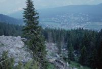
Title (German)
Flims GR, Blick (Nordansicht) vom Crap da Vadels auf Geröllhalde und den Schutzwald Uaul Preuls, im Hintergrund Flims Dorf und Flims Waldhaus
Caption
North view from Crap da Vadels onto the protective forest Uaul Preuls with boulders and debris of the landslide lying around, in the background Flims Dorf and Flims Waldhaus, 2nd follow-up image after 3 years (2000), partial view; coordinates (LV03) of the camera location: 740250/190845; keywords Documenta Natura: avalanche control, protective forest, reforestation, landslide
Caption (German)
Nordansicht vom Crap da Vadels auf den Schutzwald Uaul Preuls mit herumliegenden Felsblöcken und Geröll des Bergsturzes, im Hintergrund Flims Dorf und Flims Waldhaus, 2. Folgeaufnahme nach 3 Jahren (2000), Teilansicht; Koordinaten (LV03) des Kamerastandorts: 740250/190845; Schlagworte Documenta Natura: Lawinenverbauung, Schutzwald, Aufforstung, Bergsturz
Record Name
Dia_303-23536

Title (German)
Flims GR, Bergsturz, Waldschneise im oberen Teil des Uaul Preuls
Caption
West view of forest aisle caused by landslide with fallen spruce trees, scree gully, Flimserstein in the background (fog), first photo 1997, partial view upslope; coordinates (LV03) of camera location: 740364/190481; keywords Documenta Natura: avalanche control, protection forest, reforestation, landslide
Caption (German)
Westansicht der durch Bergsturz verursachten Waldschneise mit umgeworfenen Fichten, Geröllrinne, im Hintergrund der Flimserstein (Nebel), Erstaufnahme 1997, Teilansicht hangaufwärts; Koordinaten (LV03) des Kamerastandorts: 740364/190481; Schlagworte Documenta Natura: Lawinenverbauung, Schutzwald, Aufforstung, Bergsturz
Record Name
Dia_303-23557

Title (German)
Flims GR, Bergsturz, Waldschneise im oberen Teil des Uaul Preuls
Caption
West view of the forest aisle caused by landslide with fallen spruces, large boulder (ca. 10000 t), first photo 1997, partial view across the slope; coordinates (LV03) of camera location: 740364/190481; keywords Documenta Natura: Forest aisle caused by landslide below Flimserstein (1997-2005), near Flims/GR
Caption (German)
Westansicht der durch Bergsturz verursachten Waldschneise mit umgeworfenen Fichten, grosser Felsblock (ca. 10000 t), Erstaufnahme 1997, Teilansicht quer zum Hang; Koordinaten (LV03) des Kamerastandorts: 740364/190481; Schlagworte Documenta Natura: Durch Bergsturz verursachte Waldschneise unterhalb des Flimsersteins (1997-2005), bei Flims/GR
Record Name
Dia_303-23565

Title (German)
Flims GR, Bergsturz, Waldschneise im oberen Teil des Uaul Preuls
Caption
West view of forest aisle caused by landslide with fallen spruce trees, scree gully, Flimserstein in the background (fog), first photo 1997, partial view upslope; coordinates (LV03) of camera location: 740360/190520; keywords Documenta Natura: avalanche control, protection forest, reforestation, landslide
Caption (German)
Westansicht der durch Bergsturz verursachten Waldschneise mit umgeworfenen Fichten, Geröllrinne, im Hintergrund der Flimserstein (Nebel), Erstaufnahme 1997, Teilansicht hangaufwärts; Koordinaten (LV03) des Kamerastandorts: 740360/190520; Schlagworte Documenta Natura: Lawinenverbauung, Schutzwald, Aufforstung, Bergsturz
Record Name
Dia_303-23576

Title (German)
Flims GR, Bergsturz, Waldschneise im oberen Teil des Uaul Preuls
Caption
West view of forest aisle caused by landslide with fallen spruce trees, scree gully, Flimserstein in the background (fog), 2nd follow-up image 2000, partial view upslope; coordinates (LV03) of camera location: 740364/190481; keywords Documenta Natura: avalanche control, protection forest, reforestation, landslide.
Caption (German)
Westansicht der durch Bergsturz verursachten Waldschneise mit umgeworfenen Fichten, Geröllrinne, im Hintergrund der Flimserstein (Nebel), 2. Folgeaufnahme 2000, Teilansicht hangaufwärts; Koordinaten (LV03) des Kamerastandorts: 740364/190481; Schlagworte Documenta Natura: Lawinenverbauung, Schutzwald, Aufforstung, Bergsturz
Record Name
Dia_303-23616

Title (German)
Flims GR, Bergsturz, Waldschneise im oberen Teil des Uaul Preuls
Caption
West view of forest aisle caused by landslide with fallen spruces, large boulder (ca. 10000 t), 2nd follow-up photo 2000, partial view across the slope; coordinates (LV03) of camera location: 740364/190481; keywords Documenta Natura: Forest aisle caused by landslide below Flimserstein (1997-2005), near Flims/GR
Caption (German)
Westansicht der durch Bergsturz verursachten Waldschneise mit umgeworfenen Fichten, grosser Felsblock (ca. 10000 t), 2. Folgeaufnahme 2000, Teilansicht quer zum Hang; Koordinaten (LV03) des Kamerastandorts: 740364/190481; Schlagworte Documenta Natura: Durch Bergsturz verursachte Waldschneise unterhalb des Flimsersteins (1997-2005), bei Flims/GR
Record Name
Dia_303-23626

Title (German)
Flims GR, Bergsturz, Waldschneise im oberen Teil des Uaul Preuls
Caption
West view of forest aisle caused by landslide with fallen spruce trees, scree gully, Flimserstein in the background (fog), 2nd follow-up image 2000, partial view upslope; coordinates (LV03) of camera location: 740360/190520; keywords Documenta Natura: avalanche control, protection forest, reforestation, landslide
Caption (German)
Westansicht der durch Bergsturz verursachten Waldschneise mit umgeworfenen Fichten, Geröllrinne, im Hintergrund der Flimserstein (Nebel), 2. Folgeaufnahme 2000, Teilansicht hangaufwärts; Koordinaten (LV03) des Kamerastandorts: 740360/190520; Schlagworte Documenta Natura: Lawinenverbauung, Schutzwald, Aufforstung, Bergsturz
Record Name
Dia_303-23636

Title (German)
Flims GR, Alpweide oberhalb des Weilers Flida
Caption
Steeply sloping alpine pasture with water channel created by erosion (dry at the time), scree cone and boulders, in the background the rocky band of Flimserstein, general view upslope; coordinates (LV03) of the camera location: 73997f/19105f; keywords Documenta Natura: avalanche defense, protection forest, reforestation, landslide
Caption (German)
Steil abfallende Alpweide mit durch Erosion entstandene Wasserrinne (zum Zeitpunkt trocken), Geröllkegel und Felsblöcken, im Hintergrund das Felsband des Flimsersteines, Gesamtansicht hangaufwärts; Koordinaten (LV03) des Kamerastandorts: 73997f/19105f; Schlagworte Documenta Natura: Lawinenverbauung, Schutzwald, Aufforstung, Bergsturz
Record Name
Dia_303-23678

Title (German)
Flims GR, Südsüdwestansicht von Flims Dorf mit Flimserstein, Piz Aulta
Caption
South-southwest view of Flims village with the Flimserstein, Piz Aulta, reconstruction photo 1994, general view; coordinates (LV03) of camera location: 740435/188520; keywords Documenta Natura: avalanche control, protection forest, reforestation, landslide.
Caption (German)
Südsüdwestansicht von Flims Dorf mit dem Flimserstein, Piz Aulta, Rekonstruktionsaufnahme 1994, Gesamtansicht; Koordinaten (LV03) des Kamerastandorts: 740435/188520; Schlagworte Documenta Natura: Lawinenverbauung, Schutzwald, Aufforstung, Bergsturz
Record Name
Dia_303-23689

Title (German)
Flims GR, Lawinenverbauungsgebiet östlich des Piz Aulta
Caption
Basic structure of the steel avalanche defense system (bridge construction) in the defense area, general view; keywords Documenta Natura: avalanche defense system, protective forest, reforestation, landslide
Caption (German)
Grundgerüst vom Lawinenwerk aus Stahl (Brückenkonstruktion) im Verbauungsgebiet, Gesamtansicht; Schlagworte Documenta Natura: Lawinenverbauung, Schutzwald, Aufforstung, Bergsturz
Record Name
Dia_303-23697

Title (German)
Flims GR, Lawinenverbauungsgebiet östlich des Piz Aulta
Caption
Construction workers erecting avalanche works steel plant (bridge construction) in the construction area, general view; Keywords Documenta Natura: avalanche defense, protection forest, reforestation, landslide.
Caption (German)
Bauarbeiter beim Aufrichten von Lawinenwerken Stahlwerk (Brückenkonstruktion) im Verbauungsgebiet, Gesamtansicht; Schlagworte Documenta Natura: Lawinenverbauung, Schutzwald, Aufforstung, Bergsturz
Record Name
Dia_303-23699

Title (German)
Flims GR, Lawinenverbauungsgebiet östlich des Piz Aulta
Caption
Construction workers erecting avalanche works steel plant (bridge construction) in the construction area, partial view; Keywords Documenta Natura: avalanche defense, protection forest, reforestation, landslide.
Caption (German)
Bauarbeiter beim Aufrichten von Lawinenwerken Stahlwerk (Brückenkonstruktion) im Verbauungsgebiet, Teilansicht; Schlagworte Documenta Natura: Lawinenverbauung, Schutzwald, Aufforstung, Bergsturz
Record Name
Dia_303-23703

Title (German)
Flims GR, Lawinenverbauungsgebiet östlich des Piz Aulta
Caption
Construction workers erecting avalanche works steel plant (bridge construction) in the construction area, partial view; Keywords Documenta Natura: avalanche defense, protection forest, reforestation, landslide.
Caption (German)
Bauarbeiter beim Aufrichten von Lawinenwerken Stahlwerk (Brückenkonstruktion) im Verbauungsgebiet, Teilansicht; Schlagworte Documenta Natura: Lawinenverbauung, Schutzwald, Aufforstung, Bergsturz
Record Name
Dia_303-23711

Title (German)
Flims GR, Lawinenverbauungsgebiet östlich des Piz Aulta
Caption
Construction workers screwing the cross beams of avalanche works steel plant (bridge construction) in the area of construction, partial view; keywords Documenta Natura: avalanche construction, protective forest, reforestation, landslide.
Caption (German)
Bauarbeiter beim Verschrauben der Querträger von Lawinenwerken Stahlwerk (Brückenkonstruktion) im Verbauungsgebiet, Teilansicht; Schlagworte Documenta Natura: Lawinenverbauung, Schutzwald, Aufforstung, Bergsturz
Record Name
Dia_303-23713

Title (German)
Flims GR, Lawinenverbauungsgebiet östlich des Piz Aulta
Caption
Construction workers screwing the cross beams of avalanche works steel plant (bridge construction) in the area of construction, partial view; Keywords Documenta Natura: avalanche construction, protective forest, reforestation, landslide.
Caption (German)
Bauarbeiter beim Verschrauben der Querträger von Lawinenwerken Stahlwerk (Brückenkonstruktion) im Verbauungsgebiet, Teilansicht; Schlagworte Documenta Natura: Lawinenverbauung, Schutzwald, Aufforstung, Bergsturz
Record Name
Dia_303-23714

Title (German)
Flims GR, Lawinenverbauungsgebiet östlich des Piz Aulta
Caption
Construction workers screwing the cross beams of avalanche works steel plant (bridge construction) in the area of the shoring, general view; keywords Documenta Natura: avalanche shoring, protective forest, reforestation, landslide.
Caption (German)
Bauarbeiter beim Verschrauben der Querträger von Lawinenwerken Stahlwerk (Brückenkonstruktion) im Verbauungsgebiet, Gesamtansicht; Schlagworte Documenta Natura: Lawinenverbauung, Schutzwald, Aufforstung, Bergsturz
Record Name
Dia_303-23715

Title (German)
Flims GR, Lawinenverbauungsgebiet östlich des Piz Aulta
Caption
Construction workers screwing the cross beams of avalanche works steel plant (bridge construction) in the area of construction, partial view; Keywords Documenta Natura: avalanche construction, protective forest, reforestation, landslide.
Caption (German)
Bauarbeiter beim Verschrauben der Querträger von Lawinenwerken Stahlwerk (Brückenkonstruktion) im Verbauungsgebiet, Teilansicht; Schlagworte Documenta Natura: Lawinenverbauung, Schutzwald, Aufforstung, Bergsturz
Record Name
Dia_303-23718

Title (German)
Flims GR, Lawinenverbauungsgebiet östlich des Piz Aulta
Caption
Construction workers screwing the cross beams of avalanche works steel plant (bridge construction) in the area of construction, partial view; Keywords Documenta Natura: avalanche construction, protective forest, reforestation, landslide.
Caption (German)
Bauarbeiter beim Verschrauben der Querträger von Lawinenwerken Stahlwerk (Brückenkonstruktion) im Verbauungsgebiet, Teilansicht; Schlagworte Documenta Natura: Lawinenverbauung, Schutzwald, Aufforstung, Bergsturz
Record Name
Dia_303-23723

Title (German)
Flims GR, Lawinenverbauungsgebiet östlich des Piz Aulta
Caption
Avalanche works made of steel (bridge construction) in the area of the dam, general view; keywords Documenta Natura: avalanche dam, protective forest, reforestation, landslide.
Caption (German)
Lawinenwerke aus Stahl (Brückenkonstruktion) im Verbauungsgebiet, Gesamtansicht; Schlagworte Documenta Natura: Lawinenverbauung, Schutzwald, Aufforstung, Bergsturz
Record Name
Dia_303-23726

Title (German)
Flims GR, Lawinenverbauungsgebiet östlich des Piz Aulta
Caption
Construction workers erecting and bolting the cross beams of avalanche works steel mill (bridge structure) in the construction area, general view; keywords Documenta Natura: avalanche defense, protective forest, reforestation, landslide.
Caption (German)
Bauarbeiter beim Aufrichten und Verschrauben der Querträger von Lawinenwerken Stahlwerk (Brückenkonstruktion) im Verbauungsgebiet, Gesamtansicht; Schlagworte Documenta Natura: Lawinenverbauung, Schutzwald, Aufforstung, Bergsturz
Record Name
Dia_303-23732

Title (German)
Flims GR, Lawinenverbauungsgebiet östlich des Piz Aulta
Caption
Construction workers screwing the cross beams of avalanche works steel plant (bridge construction) in the area of construction, partial view; Keywords Documenta Natura: avalanche construction, protective forest, reforestation, landslide.
Caption (German)
Bauarbeiter beim Verschrauben der Querträger von Lawinenwerken Stahlwerk (Brückenkonstruktion) im Verbauungsgebiet, Teilansicht; Schlagworte Documenta Natura: Lawinenverbauung, Schutzwald, Aufforstung, Bergsturz
Record Name
Dia_303-23737

Title (German)
Flims GR, Lawinenverbauungsgebiet östlich des Piz Aulta
Caption
Construction workers screwing the cross beams of avalanche works steel plant (bridge construction) in the area of construction, partial view; Keywords Documenta Natura: avalanche construction, protective forest, reforestation, landslide.
Caption (German)
Bauarbeiter beim Verschrauben der Querträger von Lawinenwerken Stahlwerk (Brückenkonstruktion) im Verbauungsgebiet, Teilansicht; Schlagworte Documenta Natura: Lawinenverbauung, Schutzwald, Aufforstung, Bergsturz
Record Name
Dia_303-23740

Title (German)
Flims GR, Lawinenverbauungsgebiet östlich des Piz Aulta
Caption
District forester Thomas Färber sparking with helicopter pilot and material store; keywords Documenta Natura: avalanche defense, protection forest, reforestation, landslide.
Caption (German)
Revierförster Thomas Färber beim Funken mit Helikopterpilot und Materiallager; Schlagworte Documenta Natura: Lawinenverbauung, Schutzwald, Aufforstung, Bergsturz
Record Name
Dia_303-23744

Title (German)
Flims GR, Lawinenverbauungsgebiet östlich des Piz Aulta
Caption
District forester Thomas Färber on avalanche defense (steel bridge construction); keywords Documenta Natura: avalanche defense, protection forest, reforestation, landslide.
Caption (German)
Revierförster Thomas Färber auf Lawinenverbauung (Stahlbrückenkonstruktion); Schlagworte Documenta Natura: Lawinenverbauung, Schutzwald, Aufforstung, Bergsturz
Record Name
Dia_303-23748

Title (German)
Flims GR, Lawinenverbauungsgebiet östlich des Piz Aulta
Caption
Construction team with team leader Augostino Pires (front right) ; keywords Documenta Natura: avalanche defense, protection forest, reforestation, landslide
Caption (German)
Bautrupp mit Teamleiter Augostino Pires (vorne rechts) ; Schlagworte Documenta Natura: Lawinenverbauung, Schutzwald, Aufforstung, Bergsturz
Record Name
Dia_303-23750
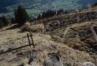
Title (German)
Flims GR, Lawinenverbauungsgebiet östlich des Piz Aulta
Caption
New avalanche works, steel works (bridge construction), view downslope with Flims at the bottom of the valley, partial view; keywords Documenta Natura: avalanche defense, protection forest, reforestation, landslide
Caption (German)
Neue Lawinenwerke, Stahlwerk (Brückenkonstruktion), Blick hangabwärts mit Flims im Talgrund, Teilansicht; Schlagworte Documenta Natura: Lawinenverbauung, Schutzwald, Aufforstung, Bergsturz
Record Name
Dia_303-23753
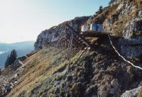
Title (German)
Flims GR, Lawinenverbauungsgebiet östlich des Piz Aulta
Caption
New avalanche works, steel works (bridge construction), view across the slope with partial Flimserstein, partial view; keywords Documenta Natura: avalanche defense, protection forest, reforestation, landslide
Caption (German)
Neue Lawinenwerke, Stahlwerk (Brückenkonstruktion), Blick quer zum Hang mit teilweise Flimserstein, Teilansicht; Schlagworte Documenta Natura: Lawinenverbauung, Schutzwald, Aufforstung, Bergsturz
Record Name
Dia_303-23755

Title (German)
Flims GR, Lawinenverbauungsgebiet östlich des Piz Aulta
Caption
New avalanche works, steel works (bridge construction), view upslope, partly still under construction, partial view; keywords Documenta Natura: avalanche defense, protection forest, reforestation, landslide.
Caption (German)
Neue Lawinenwerke, Stahlwerk (Brückenkonstruktion), Blick hangaufwärts, teilweise noch im Bau, Teilansicht; Schlagworte Documenta Natura: Lawinenverbauung, Schutzwald, Aufforstung, Bergsturz
Record Name
Dia_303-23762

Title (German)
Flims GR, Lawinenverbauungsgebiet östlich des Piz Aulta
Caption
New avalanche works (lower side), steel works (bridge construction), view across the slope, partial view; keywords Documenta Natura: avalanche defense, protection forest, reforestation, landslide
Caption (German)
Neue Lawinenwerke (untere seite), Stahlwerk (Brückenkonstruktion), Blick quer zum Hang, Teilansicht; Schlagworte Documenta Natura: Lawinenverbauung, Schutzwald, Aufforstung, Bergsturz
Record Name
Dia_303-23767

Title (German)
Flims GR, Lawinenverbauungsgebiet östlich des Piz Aulta
Caption
New avalanche works, steel works (bridge construction), mountain range in the background, partial view; keywords Documenta Natura: avalanche defense, protection forest, reforestation, landslide.
Caption (German)
Neue Lawinenwerke, Stahlwerk (Brückenkonstruktion), Gebirgskette im Hintergrund, Teilansicht; Schlagworte Documenta Natura: Lawinenverbauung, Schutzwald, Aufforstung, Bergsturz
Record Name
Dia_303-23769

Title (German)
Flims GR, Lawinenverbauungsgebiet östlich des Piz Aulta
Caption
New avalanche works, steel works (bridge construction), mountain range in the background, partial view; keywords Documenta Natura: avalanche defense, protection forest, reforestation, landslide.
Caption (German)
Neue Lawinenwerke, Stahlwerk (Brückenkonstruktion), Gebirgskette im Hintergrund, Teilansicht; Schlagworte Documenta Natura: Lawinenverbauung, Schutzwald, Aufforstung, Bergsturz
Record Name
Dia_303-23772

Title (German)
Flims GR, Lawinenverbauungsgebiet östlich des Piz Aulta
Caption
New avalanche works, steel works (bridge construction), mountain range in the background, partial view; keywords Documenta Natura: avalanche defense, protection forest, reforestation, landslide.
Caption (German)
Neue Lawinenwerke, Stahlwerk (Brückenkonstruktion), Gebirgskette im Hintergrund, Teilansicht; Schlagworte Documenta Natura: Lawinenverbauung, Schutzwald, Aufforstung, Bergsturz
Record Name
Dia_303-23775

Title (German)
Flims GR, Lawinenverbauungsgebiet östlich des Piz Aulta
Caption
New avalanche works (upper side), steel works (bridge structure), partial view; keywords Documenta Natura: avalanche defense, protective forest, reforestation, landslide.
Caption (German)
Neue Lawinenwerke (obere Seite), Stahlwerk (Brückenkonstruktion), Teilansicht; Schlagworte Documenta Natura: Lawinenverbauung, Schutzwald, Aufforstung, Bergsturz
Record Name
Dia_303-23778

Title (German)
Flims GR, Lawinenverbauungsgebiet östlich des Piz Aulta
Caption
New avalanche works, steel works (bridge construction), view down the slope with Flims in the valley, partial view; keywords Documenta Natura: avalanche defense, protection forest, reforestation, landslide
Caption (German)
Neue Lawinenwerke, Stahlwerk (Brückenkonstruktion), Blick hangabwärts mit Flims im Tal, Teilansicht; Schlagworte Documenta Natura: Lawinenverbauung, Schutzwald, Aufforstung, Bergsturz
Record Name
Dia_303-23780

Title (German)
Flims GR, Lawinenverbauungsgebiet östlich des Piz Aulta
Caption
New avalanche works, steel works (bridge construction), view across the slope, partial view; keywords Documenta Natura: avalanche defense, protective forest, reforestation, landslide.
Caption (German)
Neue Lawinenwerke, Stahlwerk (Brückenkonstruktion), Blick quer zum Hang, Teilansicht; Schlagworte Documenta Natura: Lawinenverbauung, Schutzwald, Aufforstung, Bergsturz
Record Name
Dia_303-23785
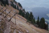
Title (German)
Flims GR, Lawinenverbauungsgebiet östlich des Piz Aulta
Caption
New avalanche works, steel works (bridge construction), view down slope, partial view; keywords Documenta Natura: avalanche defense, protection forest, reforestation, landslide.
Caption (German)
Neue Lawinenwerke, Stahlwerk (Brückenkonstruktion), Blick hangabwärts, Teilansicht; Schlagworte Documenta Natura: Lawinenverbauung, Schutzwald, Aufforstung, Bergsturz
Record Name
Dia_303-23789

Title (German)
Flims GR, Lawinenverbauungsgebiet östlich des Piz Aulta
Caption
New avalanche works, steel works (bridge construction), view down slope, partial view; keywords Documenta Natura: avalanche defense, protection forest, reforestation, landslide.
Caption (German)
Neue Lawinenwerke, Stahlwerk (Brückenkonstruktion), Blick hangabwärts, Teilansicht; Schlagworte Documenta Natura: Lawinenverbauung, Schutzwald, Aufforstung, Bergsturz
Record Name
Dia_303-23796

Title (German)
Flims GR, Lawinenverbauungsgebiet östlich des Piz Aulta
Caption
Steep slope above Flims, partial view; keywords Documenta Natura: avalanche defense, protection forest, reforestation, landslide
Caption (German)
Steilhang oberhalb von Flims, Teilansicht; Schlagworte Documenta Natura: Lawinenverbauung, Schutzwald, Aufforstung, Bergsturz
Record Name
Dia_303-23799

Title (German)
Flims GR, Lawinenverbauungsgebiet östlich des Piz Ault
Caption
Helicopter approaching the unloading site with material on the rope, general view; keywords Documenta Natura: avalanche defense, protection forest, reforestation, landslide.
Caption (German)
Helikopter beim Anflug zum Abladeplatz mit Material am Seil, Gesamtansicht; Schlagworte Documenta Natura: Lawinenverbauung, Schutzwald, Aufforstung, Bergsturz
Record Name
Dia_303-23803

Title (German)
Flims GR, Lawinenverbauungsgebiet östlich des Piz Ault
Caption
Helicopter approaching the unloading site with material on the rope, general view; keywords Documenta Natura: avalanche defense, protection forest, reforestation, landslide.
Caption (German)
Helikopter beim Anflug zum Abladeplatz mit Material am Seil, Gesamtansicht; Schlagworte Documenta Natura: Lawinenverbauung, Schutzwald, Aufforstung, Bergsturz
Record Name
Dia_303-23808

Title (German)
Flims GR, Lawinenverbauungsgebiet östlich des Piz Ault
Caption
Helicopter unloading the load, flight assistants and construction workers releasing the load, general view; keywords Documenta Natura: avalanche defense, protection forest, reforestation, landslide.
Caption (German)
Helikopter beim Abladen der Ladung, Flughelfer und Bauarbeiter beim Ausklinken der Ladung, Gesamtansicht; Schlagworte Documenta Natura: Lawinenverbauung, Schutzwald, Aufforstung, Bergsturz
Record Name
Dia_303-23810

Title (German)
Flims GR, Lawinenverbauungsgebiet östlich des Piz Ault
Caption
Helicopter unloading loads in the shoring area, flight assistants and construction workers releasing loads, general view; keywords Documenta Natura: avalanche shoring, protective forest, reforestation, landslide.
Caption (German)
Helikopter beim Abladen der Ladungen im Verbauungsgebiet, Flughelfer und Bauarbeiter beim Ausklinken von Ladungen, Gesamtansicht; Schlagworte Documenta Natura: Lawinenverbauung, Schutzwald, Aufforstung, Bergsturz
Record Name
Dia_303-23824

Title (German)
Flims GR, Lawinenverbauungsgebiet östlich des Piz Ault
Caption
Helicopter approaching the unloading site with material on the rope, general view; keywords Documenta Natura: avalanche defense, protection forest, reforestation, landslide
Caption (German)
Helikopter beim Anflug zum Abladeplatz mit Material am Seil, Gesamtansicht; Schlagworte Documenta Natura: Lawinenverbauung, Schutzwald, Aufforstung, Bergsturz
Record Name
Dia_303-23832

Title (German)
Flims GR, Lawinenverbauungsgebiet östlich des Piz Ault
Caption
Helicopter taking off to the loading area with material on the rope, general view; keywords Documenta Natura: avalanche defense, protection forest, reforestation, landslide
Caption (German)
Helikopter beim Abflug zum Ladeplatz mit Material am Seil, Gesamtansicht; Schlagworte Documenta Natura: Lawinenverbauung, Schutzwald, Aufforstung, Bergsturz
Record Name
Dia_303-23833

Title (German)
Flims GR, Lawinenverbauungsgebiet östlich des Piz Ault
Caption
Helicopter unloading loads in the shoring area, flight assistants and construction workers releasing loads, general view; keywords Documenta Natura: avalanche shoring, protective forest, reforestation, landslide.
Caption (German)
Helikopter beim Abladen der Ladungen im Verbauungsgebiet, Flughelfer und Bauarbeiter beim Ausklinken von Ladungen, Gesamtansicht; Schlagworte Documenta Natura: Lawinenverbauung, Schutzwald, Aufforstung, Bergsturz
Record Name
Dia_303-23835

Title (German)
Flims GR, Lawinenverbauungsgebiet östlich des Piz Ault
Caption
Flight assistants and construction workers releasing loads, partial view; keywords Documenta Natura: avalanche defense, protective forest, reforestation, landslide.
Caption (German)
Flughelfer und Bauarbeiter beim Ausklinken von Ladungen, Teilansicht; Schlagworte Documenta Natura: Lawinenverbauung, Schutzwald, Aufforstung, Bergsturz
Record Name
Dia_303-23852

Title (German)
Flims GR, Lawinenverbauungsgebiet östlich des Piz Ault
Caption
Flight assistants and construction workers releasing loads, partial view; keywords Documenta Natura: avalanche defense, protective forest, reforestation, landslide.
Caption (German)
Flughelfer und Bauarbeiter beim Ausklinken von Ladungen, Teilansicht; Schlagworte Documenta Natura: Lawinenverbauung, Schutzwald, Aufforstung, Bergsturz
Record Name
Dia_303-23856

Title (German)
Flims GR, Lawinenverbauungsgebiet östlich des Piz Ault
Caption
Helicopter unloading loads in the shoring area, flight assistants and construction workers releasing loads, general view; keywords Documenta Natura: avalanche shoring, protective forest, reforestation, landslide.
Caption (German)
Helikopter beim Abladen der Ladungen im Verbauungsgebiet, Flughelfer und Bauarbeiter beim Ausklinken von Ladungen, Gesamtansicht; Schlagworte Documenta Natura: Lawinenverbauung, Schutzwald, Aufforstung, Bergsturz
Record Name
Dia_303-23860

Title (German)
Flims GR, Lawinenverbauungsgebiet östlich des Piz Ault
Caption
Flight assistants and construction workers releasing loads, partial view; keywords Documenta Natura: avalanche defense, protective forest, reforestation, landslide.
Caption (German)
Flughelfer und Bauarbeiter beim Ausklinken von Ladungen, Teilansicht; Schlagworte Documenta Natura: Lawinenverbauung, Schutzwald, Aufforstung, Bergsturz
Record Name
Dia_303-23863

Title (German)
Flims GR, Lawinenverbauungsgebiet östlich des Piz Ault
Caption
Helicopter unloading loads in the shoring area, flight assistants and construction workers releasing loads, general view; keywords Documenta Natura: avalanche shoring, protective forest, reforestation, landslide.
Caption (German)
Helikopter beim Abladen der Ladungen im Verbauungsgebiet, Flughelfer und Bauarbeiter beim Ausklinken von Ladungen, Gesamtansicht; Schlagworte Documenta Natura: Lawinenverbauung, Schutzwald, Aufforstung, Bergsturz
Record Name
Dia_303-23866

Title (German)
Flims GR, Lawinenverbauungsgebiet östlich des Piz Ault
Caption
Helicopter approaching with material, general view; keywords Documenta Natura: avalanche control, protection forest, reforestation, landslide
Caption (German)
Helikopter beim Anflug mit Material, Gesamtansicht; Schlagworte Documenta Natura: Lawinenverbauung, Schutzwald, Aufforstung, Bergsturz
Record Name
Dia_303-23873

Title (German)
Flims GR, Lawinenverbauungsgebiet östlich des Piz Ault
Caption
Helicopter approaching with material, general view; keywords Documenta Natura: avalanche control, protection forest, reforestation, landslide
Caption (German)
Helikopter beim Anflug mit Material, Gesamtansicht; Schlagworte Documenta Natura: Lawinenverbauung, Schutzwald, Aufforstung, Bergsturz
Record Name
Dia_303-23876

Title (German)
Flims GR, Lawinenverbauungsgebiet östlich des Piz Ault
Caption
Helicopter (HB-XTN) in hovering flight, partial view; keywords Documenta Natura: avalanche defense, protection forest, reforestation, landslide
Caption (German)
Helikopter (HB-XTN) im Schwebeflug, Teilansicht; Schlagworte Documenta Natura: Lawinenverbauung, Schutzwald, Aufforstung, Bergsturz
Record Name
Dia_303-23883

Title (German)
Flims GR, Lawinenverbauungsgebiet östlich des Piz Ault
Caption
Construction workers preparing an explosive charge in the shoring area; keywords Documenta Natura: avalanche shoring, protective forest, reforestation, landslide.
Caption (German)
Bauarbeiter beim Vorbereiten einer Sprengladung im Verbauungsgebiet; Schlagworte Documenta Natura: Lawinenverbauung, Schutzwald, Aufforstung, Bergsturz
Record Name
Dia_303-23884

Title (German)
Flims GR, Lawinenverbauungsgebiet östlich des Piz Ault
Caption
Construction workers preparing an explosive charge in the shoring area; keywords Documenta Natura: avalanche shoring, protection forest, reforestation, landslide.
Caption (German)
Bauarbeiter beim Vorbereiten einer Sprengladung im Verbauungsgebiet; Schlagworte Documenta Natura: Lawinenverbauung, Schutzwald, Aufforstung, Bergsturz
Record Name
Dia_303-23886

Title (German)
Flims GR, Lawinenverbauungsgebiet östlich des Piz Ault
Caption
Construction workers preparing an explosive charge in the shoring area; keywords Documenta Natura: avalanche shoring, protection forest, reforestation, landslide.
Caption (German)
Bauarbeiter beim Vorbereiten einer Sprengladung im Verbauungsgebiet; Schlagworte Documenta Natura: Lawinenverbauung, Schutzwald, Aufforstung, Bergsturz
Record Name
Dia_303-23890
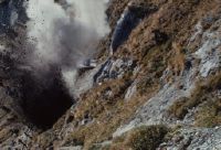
Title (German)
Flims GR, Lawinenverbauungsgebiet östlich des Piz Ault
Caption
Explosion of the explosive charge; keywords Documenta Natura: avalanche defense, protective forest, reforestation, landslide.
Caption (German)
Explosion der Sprengladung; Schlagworte Documenta Natura: Lawinenverbauung, Schutzwald, Aufforstung, Bergsturz
Record Name
Dia_303-23891

Title (German)
Flims GR, Lawinenverbauungsgebiet östlich des Piz Ault
Caption
Construction worker building path with jackhammer and shovel; keywords Documenta Natura: avalanche protection, protection forest, reforestation, landslide
Caption (German)
Bauarbeiter bei Wegbauarbeiten mit Presslufthammer und Schaufel; Schlagworte Documenta Natura: Lawinenverbauung, Schutzwald, Aufforstung, Bergsturz
Record Name
Dia_303-23911

Title (German)
Flims GR, Lawinenverbauungsgebiet östlich des Piz Ault
Caption
Construction worker building path with jackhammer and shovel; keywords Documenta Natura: avalanche protection, protection forest, reforestation, landslide
Caption (German)
Bauarbeiter bei Wegbauarbeiten mit Presslufthammer und Schaufel; Schlagworte Documenta Natura: Lawinenverbauung, Schutzwald, Aufforstung, Bergsturz
Record Name
Dia_303-23913

Title (German)
Flims GR, Lawinenverbauungsgebiet östlich des Piz Ault
Caption
Construction worker building path with jackhammer and shovel; keywords Documenta Natura: avalanche protection, protection forest, reforestation, landslide
Caption (German)
Bauarbeiter bei Wegbauarbeiten mit Presslufthammer und Schaufel; Schlagworte Documenta Natura: Lawinenverbauung, Schutzwald, Aufforstung, Bergsturz
Record Name
Dia_303-23916

Title (German)
Flims GR, Lawinenverbauungsgebiet östlich des Piz Ault
Caption
Construction worker building path with jackhammer and shovel; keywords Documenta Natura: avalanche protection, protection forest, reforestation, landslide
Caption (German)
Bauarbeiter bei Wegbauarbeiten mit Presslufthammer und Schaufel; Schlagworte Documenta Natura: Lawinenverbauung, Schutzwald, Aufforstung, Bergsturz
Record Name
Dia_303-23927

Title (German)
Flims GR, Lawinenverbauungsgebiet östlich des Piz Ault
Caption
Construction worker building path with jackhammer and shovel; keywords Documenta Natura: avalanche protection, protection forest, reforestation, landslide
Caption (German)
Bauarbeiter bei Wegbauarbeiten mit Presslufthammer und Schaufel; Schlagworte Documenta Natura: Lawinenverbauung, Schutzwald, Aufforstung, Bergsturz
Record Name
Dia_303-23929

Title (German)
Flims GR, Lawinenverbauungsgebiet östlich des Piz Ault
Caption
Construction worker building path with jackhammer and shovel; keywords Documenta Natura: avalanche protection, protection forest, reforestation, landslide
Caption (German)
Bauarbeiter bei Wegbauarbeiten mit Presslufthammer und Schaufel; Schlagworte Documenta Natura: Lawinenverbauung, Schutzwald, Aufforstung, Bergsturz
Record Name
Dia_303-23932

Title (German)
Flims GR, Lawinenverbauungsgebiet östlich des Piz Ault
Caption
Compressor and tool chest on small terrace in construction area, partial view; keywords Documenta Natura: avalanche defense, protection forest, reforestation, landslide.
Caption (German)
Kompressor und Werkzeugtruhe auf kleiner Terrasse im Verbauungsgebiet, Teilansicht; Schlagworte Documenta Natura: Lawinenverbauung, Schutzwald, Aufforstung, Bergsturz
Record Name
Dia_303-23941

Title (German)
Flims GR, Oberhalb des Lawinenverbauungsgebietes östlich des Piz Ault
Caption
New wooden hunting lodge, log cabin with tin roof, general view; keywords Documenta Natura: avalanche defense, protection forest, reforestation, landslide.
Caption (German)
Neue Jagdhütte aus Holz, Blockhütte mit Blechdach, Gesamtansicht; Schlagworte Documenta Natura: Lawinenverbauung, Schutzwald, Aufforstung, Bergsturz
Record Name
Dia_303-23946

Title (German)
Flims GR, Oberhalb des Lawinenverbauungsgebietes östlich des Piz Ault
Caption
Accommodation container for construction workers, above the shoring area, general view; keywords Documenta Natura: avalanche shoring, protective forest, reforestation, landslide.
Caption (German)
Unterkunftscontainer für Bauarbeiter, oberhalb des Verbauungsgebietes, Gesamtansicht; Schlagworte Documenta Natura: Lawinenverbauung, Schutzwald, Aufforstung, Bergsturz
Record Name
Dia_303-23947

Title (German)
Flims GR, Bergstation der Luftseilbahn Fidaz-Flimserstein
Caption
Mountain station, pasture in the foreground and the mountain range in the background, general view; keywords Documenta Natura: avalanche defense, protection forest, reforestation, landslide.
Caption (German)
Bergstation, im Vordergrund Weide und im Hintergrund die Gebirgskette, Gesamtansicht; Schlagworte Documenta Natura: Lawinenverbauung, Schutzwald, Aufforstung, Bergsturz
Record Name
Dia_303-23950

Title (German)
Flims GR, Bergstation der Luftseilbahn Fidaz-Flimserstein
Caption
Mountain station and residential house, in the background the mountain range, partial view; keywords Documenta Natura: avalanche protection, protection forest, reforestation, landslide
Caption (German)
Bergstation und Wohnhaus, im Hintergrund die Gebirgskette, Teilansicht; Schlagworte Documenta Natura: Lawinenverbauung, Schutzwald, Aufforstung, Bergsturz
Record Name
Dia_303-23952
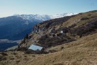
Title (German)
Flims GR, Lawinenverbauungsgebiet östlich des Piz Ault
Caption
Avalanche control area with the new avalanche works, the hunting lodge and the accommodation containers, in the background Flims and mountain range, higher elevations covered with snow, general view; keywords Documenta Natura: avalanche control, protection forest, reforestation, landslide
Caption (German)
Lawinenverbauungsgebiet mit den neuen Lawinenwerken, der Jagdhütte und den Unterkunftscontainern, im Hintergrund Flims und Gebirgskette, höhere Lagen schneebedeckt, Gesamtansicht; Schlagworte Documenta Natura: Lawinenverbauung, Schutzwald, Aufforstung, Bergsturz
Record Name
Dia_303-23954

Title (German)
Flims GR, Lawinenverbauungsgebiet östlich des Piz Ault
Caption
Avalanche control area with the new avalanche works, the hunting lodge and the accommodation containers, in the background Flims and mountain range, higher elevations covered with snow, general view; keywords Documenta Natura: avalanche control, protection forest, reforestation, landslide
Caption (German)
Lawinenverbauungsgebiet mit den neuen Lawinenwerken, der Jagdhütte und den Unterkunftscontainern, im Hintergrund Flims und Gebirgskette, höhere Lagen schneebedeckt, Gesamtansicht; Schlagworte Documenta Natura: Lawinenverbauung, Schutzwald, Aufforstung, Bergsturz
Record Name
Dia_303-23957

Title (German)
Flims GR, Lawinenverbauungsgebiet östlich des Piz Ault
Caption
Avalanche control area with the new avalanche works, partial view down the valley; keywords Documenta Natura: avalanche control, protective forest, reforestation, landslide.
Caption (German)
Lawinenverbauungsgebiet mit den neuen Lawinenwerken, Teilansicht talabwärts; Schlagworte Documenta Natura: Lawinenverbauung, Schutzwald, Aufforstung, Bergsturz
Record Name
Dia_303-23961

Title (German)
Flims GR, Lawinenverbauungsgebiet östlich des Piz Ault
Caption
Avalanche control area with the new avalanche works, partial view down the valley; keywords Documenta Natura: avalanche control, protective forest, reforestation, landslide.
Caption (German)
Lawinenverbauungsgebiet mit den neuen Lawinenwerken, Teilansicht talabwärts; Schlagworte Documenta Natura: Lawinenverbauung, Schutzwald, Aufforstung, Bergsturz
Record Name
Dia_303-23964

Title (German)
Flims GR, Lawinenverbauungsgebiet östlich des Piz Ault
Caption
Avalanche control area with the new avalanche works, partial view across the slope; keywords Documenta Natura: avalanche control, protective forest, reforestation, landslide.
Caption (German)
Lawinenverbauungsgebiet mit den neuen Lawinenwerken, Teilansicht quer zum Hang; Schlagworte Documenta Natura: Lawinenverbauung, Schutzwald, Aufforstung, Bergsturz
Record Name
Dia_303-23965

Title (German)
Flims GR, Flimserstein westlich (Pinut, Pardatsch) und östlich der Luftseilbahn Fidaz-Flimserstein
Caption
Massif of the Flimserstein seen from the cable car Fidaz-Flimserstein, partial view; keywords Documenta Natura: avalanche defense, protection forest, reforestation, landslide
Caption (German)
Massiv des Flimserstein aus der Luftseilbahn Fidaz-Flimserstein gesehen, Teilansicht; Schlagworte Documenta Natura: Lawinenverbauung, Schutzwald, Aufforstung, Bergsturz
Record Name
Dia_303-23971

Title (German)
Flims GR, Flimserstein westlich (Pinut, Pardatsch) und östlich der Luftseilbahn Fidaz-Flimserstein
Caption
Massif of the Flimserstein seen from the cable car Fidaz-Flimserstein, partial view; keywords Documenta Natura: avalanche defense, protection forest, reforestation, landslide
Caption (German)
Massiv des Flimserstein aus der Luftseilbahn Fidaz-Flimserstein gesehen, Teilansicht; Schlagworte Documenta Natura: Lawinenverbauung, Schutzwald, Aufforstung, Bergsturz
Record Name
Dia_303-23975

Title (German)
Flims GR, Flimserstein westlich (Pinut, Pardatsch) und östlich der Luftseilbahn Fidaz-Flimserstein
Caption
Massif of the Flimserstein seen from the cable car Fidaz-Flimserstein, partial view; keywords Documenta Natura: avalanche defense, protection forest, reforestation, landslide
Caption (German)
Massiv des Flimserstein aus der Luftseilbahn Fidaz-Flimserstein gesehen, Teilansicht; Schlagworte Documenta Natura: Lawinenverbauung, Schutzwald, Aufforstung, Bergsturz
Record Name
Dia_303-23977
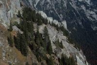
Title (German)
Flims GR, Flimserstein westlich (Pinut, Pardatsch) und östlich der Luftseilbahn Fidaz-Flimserstein
Caption
Massif of the Flimserstein seen from the cable car Fidaz-Flimserstein, partial view; keywords Documenta Natura: avalanche defense, protection forest, reforestation, landslide
Caption (German)
Massiv des Flimserstein aus der Luftseilbahn Fidaz-Flimserstein gesehen, Teilansicht; Schlagworte Documenta Natura: Lawinenverbauung, Schutzwald, Aufforstung, Bergsturz
Record Name
Dia_303-23979

Title (German)
Flims GR, Flimserstein westlich (Pinut, Pardatsch) und östlich der Luftseilbahn Fidaz-Flimserstein
Caption
Massif of the Flimserstein seen from the cable car Fidaz-Flimserstein, partial view; keywords Documenta Natura: avalanche defense, protection forest, reforestation, landslide
Caption (German)
Massiv des Flimserstein aus der Luftseilbahn Fidaz-Flimserstein gesehen, Teilansicht; Schlagworte Documenta Natura: Lawinenverbauung, Schutzwald, Aufforstung, Bergsturz
Record Name
Dia_303-23981

Title (German)
Flims GR, Flimserstein westlich (Pinut, Pardatsch) und östlich der Luftseilbahn Fidaz-Flimserstein
Caption
Massif of the Flimserstein seen from the cable car Fidaz-Flimserstein, Flims in the background, partial view; keywords Documenta Natura: avalanche defense, protection forest, reforestation, landslide
Caption (German)
Massiv des Flimserstein aus der Luftseilbahn Fidaz-Flimserstein gesehen, Flims im Hintergrund, Teilansicht; Schlagworte Documenta Natura: Lawinenverbauung, Schutzwald, Aufforstung, Bergsturz
Record Name
Dia_303-23983
Title (German)
Flims GR, Flimserstein westlich (Pinut, Pardatsch) und östlich der Luftseilbahn Fidaz-Flimserstein
Caption
Massif of the Flimserstein seen from the cable car Fidaz-Flimserstein, Flims in the background, partial view; keywords Documenta Natura: avalanche defense, protection forest, reforestation, landslide
Caption (German)
Massiv des Flimserstein aus der Luftseilbahn Fidaz-Flimserstein gesehen, Flims im Hintergrund, Teilansicht; Schlagworte Documenta Natura: Lawinenverbauung, Schutzwald, Aufforstung, Bergsturz
Record Name
Dia_303-23985

Title (German)
Flims GR, Flimserstein westlich (Pinut, Pardatsch) und östlich der Luftseilbahn Fidaz-Flimserstein
Caption
Massif of the Flimserstein seen from the cable car Fidaz-Flimserstein, partial view; keywords Documenta Natura: avalanche defense, protection forest, reforestation, landslide
Caption (German)
Massiv des Flimserstein aus der Luftseilbahn Fidaz-Flimserstein gesehen, Teilansicht; Schlagworte Documenta Natura: Lawinenverbauung, Schutzwald, Aufforstung, Bergsturz
Record Name
Dia_303-23987

Title (German)
Flims GR, Flimserstein westlich (Pinut, Pardatsch) und östlich der Luftseilbahn Fidaz-Flimserstein
Caption
Massif of the Flimserstein seen from the cable car Fidaz-Flimserstein, partial view; keywords Documenta Natura: avalanche defense, protection forest, reforestation, landslide
Caption (German)
Massiv des Flimserstein aus der Luftseilbahn Fidaz-Flimserstein gesehen, Teilansicht; Schlagworte Documenta Natura: Lawinenverbauung, Schutzwald, Aufforstung, Bergsturz
Record Name
Dia_303-23989

Title (German)
Flims GR, Flimserstein westlich (Pinut, Pardatsch) und östlich der Luftseilbahn Fidaz-Flimserstein
Caption
Massif of Flimserstein seen from the cable car Fidaz-Flimserstein, crest with forest edge and precipice, partial view; keywords Documenta Natura: avalanche defense, protection forest, reforestation, landslide
Caption (German)
Massiv des Flimserstein aus der Luftseilbahn Fidaz-Flimserstein gesehen, Krete mit Waldrand und Abgrund, Teilansicht; Schlagworte Documenta Natura: Lawinenverbauung, Schutzwald, Aufforstung, Bergsturz
Record Name
Dia_303-23991

Title (German)
Flims GR, Flimserstein westlich (Pinut, Pardatsch) und östlich der Luftseilbahn Fidaz-Flimserstein
Caption
Upper part of the massif of Flimserstein seen from the cable car Fidaz-Flimserstein, Flims in the background, partial view; keywords Documenta Natura: avalanche control, protection forest, reforestation, landslide
Caption (German)
Oberer Teil vom Massiv des Flimserstein aus der Luftseilbahn Fidaz-Flimserstein gesehen, Flims im Hintergrund, Teilansicht; Schlagworte Documenta Natura: Lawinenverbauung, Schutzwald, Aufforstung, Bergsturz
Record Name
Dia_303-23995

Title (German)
Flims GR, Lawinenverbauungsgebiet östlich des Piz Ault
Caption
Supporting pillars of the new avalanche works (steel bridge structure), partial view; keywords Documenta Natura: avalanche defense, protective forest, reforestation, landslide.
Caption (German)
Stützpfeiler der neuen Lawinenwerke (Stahlbrückenkonstruktion), Teilansicht; Schlagworte Documenta Natura: Lawinenverbauung, Schutzwald, Aufforstung, Bergsturz
Record Name
Dia_303-23997

Title (German)
Flims GR, Lawinenverbauungsgebiet östlich des Piz Ault
Caption
Supporting pillars of the new avalanche works (steel bridge construction), general view; keywords Documenta Natura: avalanche defense, protective forest, reforestation, landslide.
Caption (German)
Stützpfeiler der neuen Lawinenwerke (Stahlbrückenkonstruktion), Gesamtansicht; Schlagworte Documenta Natura: Lawinenverbauung, Schutzwald, Aufforstung, Bergsturz
Record Name
Dia_303-24000

Title (German)
Flims GR, Lawinenverbauungsgebiet östlich des Piz Ault
Caption
Supporting pillars of the new avalanche works (steel bridge structure), partial view; keywords Documenta Natura: avalanche defense, protective forest, reforestation, landslide.
Caption (German)
Stützpfeiler der neuen Lawinenwerke (Stahlbrückenkonstruktion), Teilansicht; Schlagworte Documenta Natura: Lawinenverbauung, Schutzwald, Aufforstung, Bergsturz
Record Name
Dia_303-24003

Title (German)
Flims GR, Lawinenverbauungsgebiet östlich des Piz Ault
Caption
Supporting pillars of the new avalanche works (steel bridge construction), detail view; Keywords Documenta Natura: avalanche defense, protective forest, reforestation, landslide.
Caption (German)
Stützpfeiler der neuen Lawinenwerke (Stahlbrückenkonstruktion), Detailansicht; Schlagworte Documenta Natura: Lawinenverbauung, Schutzwald, Aufforstung, Bergsturz
Record Name
Dia_303-24006

Title (German)
Flims GR, Lawinenverbauungsgebiet östlich des Piz Ault
Caption
Supporting pillars of the new avalanche works (steel bridge construction), detail view; Keywords Documenta Natura: avalanche defense, protective forest, reforestation, landslide.
Caption (German)
Stützpfeiler der neuen Lawinenwerke (Stahlbrückenkonstruktion), Detailansicht; Schlagworte Documenta Natura: Lawinenverbauung, Schutzwald, Aufforstung, Bergsturz
Record Name
Dia_303-24008

Title (German)
Flims GR, Lawinenverbauungsgebiet östlich des Piz Ault
Caption
Construction workers concreting the base of the supporting pillar; keywords Documenta Natura: avalanche protection, protective forest, reforestation, landslide
Caption (German)
Bauarbeiter beim Einbetonieren des Sockels vom Stützpfeiler; Schlagworte Documenta Natura: Lawinenverbauung, Schutzwald, Aufforstung, Bergsturz
Record Name
Dia_303-24013

Title (German)
Flims GR, Lawinenverbauungsgebiet östlich des Piz Ault
Caption
Construction workers concreting the base of the supporting pillar; keywords Documenta Natura: avalanche protection, protective forest, reforestation, landslide
Caption (German)
Bauarbeiter beim Einbetonieren des Sockels vom Stützpfeiler; Schlagworte Documenta Natura: Lawinenverbauung, Schutzwald, Aufforstung, Bergsturz
Record Name
Dia_303-24015

Title (German)
Falera GR, An der Strasse ins Val da Cafegns oberhalb Falera
Caption
Upper side of landslide in road embankment, with embankment protection by boulders, general view; coordinates (LV03) of camera location: 735338/185625; keywords Documenta Natura: mountain forest, thinning.
Caption (German)
Obere Seite der Rutschung in Strassenböschung, mit Böschungssicherung durch Blocksteine, Gesamtansicht; Koordinaten (LV03) des Kamerastandorts: 735338/185625; Schlagworte Documenta Natura: Gebirgswald, Durchforstung
Record Name
Dia_303-24020

Title (German)
Falera GR, An der Strasse ins Val da Cafegns oberhalb Falera
Caption
Upper side of landslide in road embankment, with embankment protection by boulders, first photograph 1989, general view; coordinates (LV03) of camera location: 735338/185625; keywords Documenta Natura: mountain forest, thinning.
Caption (German)
Obere Seite der Rutschung in Strassenböschung, mit Böschungssicherung durch Blocksteine, Erstaufnahme 1989, Gesamtansicht; Koordinaten (LV03) des Kamerastandorts: 735338/185625; Schlagworte Documenta Natura: Gebirgswald, Durchforstung
Record Name
Dia_303-24022

Title (German)
Falera GR, An der Strasse ins Val da Cafegns oberhalb Falera
Caption
Upper side of landslide in road embankment, with embankment protection by boulders, general view; coordinates (LV03) of camera location: 735325/185640; keywords Documenta Natura: mountain forest, thinning.
Caption (German)
Obere Seite der Rutschung in Strassenböschung, mit Böschungssicherung durch Blocksteine, Gesamtansicht; Koordinaten (LV03) des Kamerastandorts: 735325/185640; Schlagworte Documenta Natura: Gebirgswald, Durchforstung
Record Name
Dia_303-24025

Title (German)
Falera GR, An der Strasse ins Val da Cafegns oberhalb Falera
Caption
Embankment shoring below the road, general view; coordinates (LV03) of camera location: 735315/185635; keywords Documenta Natura: mountain forest, thinning.
Caption (German)
Böschungsverbau unterhalb der Strasse, Gesamtansicht; Koordinaten (LV03) des Kamerastandorts: 735315/185635; Schlagworte Documenta Natura: Gebirgswald, Durchforstung
Record Name
Dia_303-24030

Title (German)
Falera GR, An der Strasse ins Val da Cafegns oberhalb Falera
Caption
Embankment shoring below the road, partial view; coordinates (LV03) of camera location: 735315/185635; keywords Documenta Natura: mountain forest, thinning.
Caption (German)
Böschungsverbau unterhalb der Strasse, Teilansicht; Koordinaten (LV03) des Kamerastandorts: 735315/185635; Schlagworte Documenta Natura: Gebirgswald, Durchforstung
Record Name
Dia_303-24034

Title (German)
Falera GR, An der Strasse ins Val da Cafegns oberhalb Falera
Caption
Various landslides in road embankments, some with embankment shoring, green shoring, at the forest edge or in the forest; coordinates (LV03) of camera location: 735060/185700; keywords Documenta Natura: mountain forest, thinning.
Caption (German)
Verschiedene Rutschungen in Strassenböschungen, z. T. mit Böschungsverbau, Grünverbau, am Waldrand oder im Wald; Koordinaten (LV03) des Kamerastandorts: 735060/185700; Schlagworte Documenta Natura: Gebirgswald, Durchforstung
Record Name
Dia_303-24035

Title (German)
Falera GR, An der Strasse ins Val da Cafegns oberhalb Falera
Caption
Upper side of slide in road embankment, with embankment protection by boulders, 1st follow-up photograph 1996, general view; coordinates (LV03) of camera location: 735338/185625; keywords Documenta Natura: mountain forest, thinning.
Caption (German)
Obere Seite der Rutschung in Strassenböschung, mit Böschungssicherung durch Blocksteine, 1. Folgeaufnahme 1996, Gesamtansicht; Koordinaten (LV03) des Kamerastandorts: 735338/185625; Schlagworte Documenta Natura: Gebirgswald, Durchforstung
Record Name
Dia_303-24042

Title (German)
Falera GR, Strasse nach Parmun südlich von Falera
Caption
Road embankment secured with nets (jute cloth), general view; keywords Documenta Natura: mountain forest, thinning
Caption (German)
Mit Netzen (Jutestoff) gesicherte Strassenböschung, Gesamtansicht; Schlagworte Documenta Natura: Gebirgswald, Durchforstung
Record Name
Dia_303-24052

Title (German)
Falera GR, Strasse nach Parmun südlich von Falera
Caption
Road embankment secured with nets (jute cloth), partial view; keywords Documenta Natura: mountain forest, thinning.
Caption (German)
Mit Netzen (Jutestoff) gesicherte Strassenböschung, Teilansicht; Schlagworte Documenta Natura: Gebirgswald, Durchforstung
Record Name
Dia_303-24055
Title (German)
Falera GR, Strasse nach Parmun südlich von Falera
Caption
Road embankment secured with nets (jute cloth), partial view; keywords Documenta Natura: mountain forest, thinning.
Caption (German)
Mit Netzen (Jutestoff) gesicherte Strassenböschung, Teilansicht; Schlagworte Documenta Natura: Gebirgswald, Durchforstung
Record Name
Dia_303-24057

Title (German)
Falera GR, Strasse nach Parmun südlich von Falera
Caption
Road embankment secured with nets (jute cloth), partial view; keywords Documenta Natura: mountain forest, thinning.
Caption (German)
Mit Netzen (Jutestoff) gesicherte Strassenböschung, Teilansicht; Schlagworte Documenta Natura: Gebirgswald, Durchforstung
Record Name
Dia_303-24059

Title (German)
Falera GR, Strasse nach Parmun südlich von Falera
Caption
Road embankment secured with nets (jute cloth), detail view; keywords Documenta Natura: mountain forest, thinning.
Caption (German)
Mit Netzen (Jutestoff) gesicherte Strassenböschung, Detailansicht; Schlagworte Documenta Natura: Gebirgswald, Durchforstung
Record Name
Dia_303-24061

Title (German)
Falera GR, Im Val Dado nordwestlich von Falera
Caption
Landslide and erosion surface in mountain forest, partial view (1989); coordinates (LV03) of camera location: 7357ff/1856ff; keywords Documenta Natura: mountain forest, thinning.
Caption (German)
Rutschung und Erosionsfläche im Gebirgswald, Teilansicht (1989); Koordinaten (LV03) des Kamerastandorts: 7357ff/1856ff; Schlagworte Documenta Natura: Gebirgswald, Durchforstung
Record Name
Dia_303-24064

Title (German)
Falera GR, Im Val Dado nordwestlich von Falera
Caption
Landslide and erosion surface in mountain forest, first photograph 1989, partial view; coordinates (LV03) of camera location: 7357ff/1856ff; keywords Documenta Natura: mountain forest, thinning.
Caption (German)
Rutschung und Erosionsfläche im Gebirgswald, Erstaufnahme 1989, Teilansicht; Koordinaten (LV03) des Kamerastandorts: 7357ff/1856ff; Schlagworte Documenta Natura: Gebirgswald, Durchforstung
Record Name
Dia_303-24067

Title (German)
Falera GR, Im Val Dado nordwestlich von Falera
Caption
Landslide and erosion surface in mountain forest, with stream, first photograph 1989, partial view; coordinates (LV03) of camera location: 7357ff/1856ff; keywords Documenta Natura: mountain forest, thinning.
Caption (German)
Rutschung und Erosionsfläche im Gebirgswald, mit Bach, Erstaufnahme 1989, Teilansicht; Koordinaten (LV03) des Kamerastandorts: 7357ff/1856ff; Schlagworte Documenta Natura: Gebirgswald, Durchforstung
Record Name
Dia_303-24070

Title (German)
Falera GR, Im Val Dado nordwestlich von Falera
Caption
Landslide and erosion surface in mountain forest, with stream, first photograph 1989, partial view; coordinates (LV03) of camera location: 7357ff/1856ff; keywords Documenta Natura: mountain forest, thinning.
Caption (German)
Rutschung und Erosionsfläche im Gebirgswald, mit Bach, Erstaufnahme 1989, Teilansicht; Koordinaten (LV03) des Kamerastandorts: 7357ff/1856ff; Schlagworte Documenta Natura: Gebirgswald, Durchforstung
Record Name
Dia_303-24077

Title (German)
Falera GR, Im Val Dado nordwestlich von Falera
Caption
Erosion area in mountain forest, slipped trees, partial view (1989); coordinates (LV03) of camera location: 7357ff/1856ff; keywords Documenta Natura: mountain forest, thinning.
Caption (German)
Erosionsfläche im Gebirgswald, abgerutschte Bäume, Teilansicht (1989); Koordinaten (LV03) des Kamerastandorts: 7357ff/1856ff; Schlagworte Documenta Natura: Gebirgswald, Durchforstung
Record Name
Dia_303-24082

Title (German)
Falera GR, Im Val Dado nordwestlich von Falera
Caption
Erosion area in mountain forest, slipped trees, partial view (1989); coordinates (LV03) of camera location: 7357ff/1856ff; keywords Documenta Natura: mountain forest, thinning.
Caption (German)
Erosionsfläche im Gebirgswald, abgerutschte Bäume, Teilansicht (1989); Koordinaten (LV03) des Kamerastandorts: 7357ff/1856ff; Schlagworte Documenta Natura: Gebirgswald, Durchforstung
Record Name
Dia_303-24086

Title (German)
Falera GR, Im Val Dado nordwestlich von Falera
Caption
Mountain stream with landslides and erosion surfaces, partial view (1989); coordinates (LV03) of camera location: 7357ff/1856ff; keywords Documenta Natura: mountain forest, thinning.
Caption (German)
Gebirgsbach mit Rutschungen und Erosionsflächen, Teilansicht (1989); Koordinaten (LV03) des Kamerastandorts: 7357ff/1856ff; Schlagworte Documenta Natura: Gebirgswald, Durchforstung
Record Name
Dia_303-24090

Title (German)
Falera GR, Im Val Dado nordwestlich von Falera
Caption
Mountain stream with landslides and erosion surfaces, first photograph 1989, partial view; coordinates (LV03) of camera location: 7357ff/1856ff; keywords Documenta Natura: mountain forest, thinning.
Caption (German)
Gebirgsbach mit Rutschungen und Erosionsflächen, Erstaufnahme 1989, Teilansicht; Koordinaten (LV03) des Kamerastandorts: 7357ff/1856ff; Schlagworte Documenta Natura: Gebirgswald, Durchforstung
Record Name
Dia_303-24095

Title (German)
Falera GR, Im Val Dado nordwestlich von Falera
Caption
Landslide and erosion surface in mountain forest, with stream, first photograph 1989, partial view; coordinates (LV03) of camera location: 7357ff/1856ff; keywords Documenta Natura: mountain forest, thinning.
Caption (German)
Rutschung und Erosionsfläche im Gebirgswald, mit Bach, Erstaufnahme 1989, Teilansicht; Koordinaten (LV03) des Kamerastandorts: 7357ff/1856ff; Schlagworte Documenta Natura: Gebirgswald, Durchforstung
Record Name
Dia_303-24099

Title (German)
Falera GR, Im Val Dado nordwestlich von Falera
Caption
Landslide and erosion surface in mountain forest, with stream, partial view (1989); coordinates (LV03) of camera location: 7357ff/1856ff; keywords Documenta Natura: mountain forest, thinning.
Caption (German)
Rutschung und Erosionsfläche im Gebirgswald, mit Bach, Teilansicht (1989); Koordinaten (LV03) des Kamerastandorts: 7357ff/1856ff; Schlagworte Documenta Natura: Gebirgswald, Durchforstung
Record Name
Dia_303-24105

Title (German)
Falera GR, Im Val Dado nordwestlich von Falera
Caption
Landslide and erosion surface in mountain forest, with stream, partial view (1989); coordinates (LV03) of camera location: 7357ff/1856ff; keywords Documenta Natura: mountain forest, thinning.
Caption (German)
Rutschung und Erosionsfläche im Gebirgswald, mit Bach, Teilansicht (1989); Koordinaten (LV03) des Kamerastandorts: 7357ff/1856ff; Schlagworte Documenta Natura: Gebirgswald, Durchforstung
Record Name
Dia_303-24108

Title (German)
Falera GR, Im Val Dado nordwestlich von Falera
Caption
Landslide and erosion surface in mountain forest (fallen trees), with stream, partial view (1989); keywords Documenta Natura: mountain forest, thinning
Caption (German)
Rutschung und Erosionsfläche im Gebirgswald (umgestürzte Bäume), mit Bach, Teilansicht (1989); Schlagworte Documenta Natura: Gebirgswald, Durchforstung
Record Name
Dia_303-24114
Title (German)
Falera GR, Im Val Dado nordwestlich von Falera
Caption
Mountain stream with landslide and erosion surface, with stream, partial view (1989); keywords Documenta Natura: mountain forest, thinning
Caption (German)
Gebirgsbach mit Rutschung und Erosionsfläche, mit Bach, Teilansicht (1989); Schlagworte Documenta Natura: Gebirgswald, Durchforstung
Record Name
Dia_303-24118

Title (German)
Falera GR, Im Val Dado nordwestlich von Falera
Caption
Mountain stream with landslide and erosion surface, with stream, partial view (1989); keywords Documenta Natura: mountain forest, thinning
Caption (German)
Gebirgsbach mit Rutschung und Erosionsfläche, mit Bach, Teilansicht (1989); Schlagworte Documenta Natura: Gebirgswald, Durchforstung
Record Name
Dia_303-24121

Title (German)
Falera GR, Im Val Dado nordwestlich von Falera
Caption
Landslide and erosion surfaces in mountain forest, with fallen trees, partial view (1989); keywords Documenta Natura: mountain forest, thinning
Caption (German)
Rutschung und Erosionsflächenen im Gebirgswald, mit umgestürzten Bäumen, Teilansicht (1989); Schlagworte Documenta Natura: Gebirgswald, Durchforstung
Record Name
Dia_303-24124

Title (German)
Falera GR, Im Val Dado nordwestlich von Falera
Caption
Landslide and erosion surfaces in mountain forest, partial view (1989); keywords Documenta Natura: mountain forest, thinning
Caption (German)
Rutschung und Erosionsflächenen im Gebirgswald, Teilansicht (1989); Schlagworte Documenta Natura: Gebirgswald, Durchforstung
Record Name
Dia_303-24128

Title (German)
Falera GR, Im Val Dado nordwestlich von Falera
Caption
Landslide and erosion surface in mountain forest, 1st follow-up image 1996, partial view; coordinates (LV03) of camera location: 7357ff/1856ff; keywords Documenta Natura: mountain forest, thinning.
Caption (German)
Rutschung und Erosionsfläche im Gebirgswald, 1. Folgeaufnahme 1996, Teilansicht; Koordinaten (LV03) des Kamerastandorts: 7357ff/1856ff; Schlagworte Documenta Natura: Gebirgswald, Durchforstung
Record Name
Dia_303-24133

Title (German)
Falera GR, Im Val Dado nordwestlich von Falera
Caption
Landslide and erosion area in mountain forest, with stream and fallen trees, 1st follow-up photograph 1996, partial view ; coordinates (LV03) of camera location: 7357ff/1856ff; keywords Documenta Natura: mountain forest, thinning.
Caption (German)
Rutschung und Erosionsfläche im Gebirgswald, mit Bach und umgestürzten Bäumen, 1. Folgeaufnahme 1996, Teilansicht ; Koordinaten (LV03) des Kamerastandorts: 7357ff/1856ff; Schlagworte Documenta Natura: Gebirgswald, Durchforstung
Record Name
Dia_303-24140

Title (German)
Falera GR, Im Val Dado nordwestlich von Falera
Caption
Landslide and erosion area in mountain forest, with stream and fallen trees, 1st follow-up photograph 1996, partial view ; coordinates (LV03) of camera location: 7357ff/1856ff; keywords Documenta Natura: mountain forest, thinning.
Caption (German)
Rutschung und Erosionsfläche im Gebirgswald, mit Bach und umgestürzten Bäumen, 1. Folgeaufnahme 1996, Teilansicht ; Koordinaten (LV03) des Kamerastandorts: 7357ff/1856ff; Schlagworte Documenta Natura: Gebirgswald, Durchforstung
Record Name
Dia_303-24148

Title (German)
Falera GR, Im Val Dado nordwestlich von Falera
Caption
Mountain stream with landslides and erosion surfaces, 1st follow-up photograph 1996, partial view; coordinates (LV03) of camera location: 7357ff/1856ff; keywords Documenta Natura: mountain forest, thinning.
Caption (German)
Gebirgsbach mit Rutschungen und Erosionsflächen, 1. Folgeaufnahme 1996, Teilansicht; Koordinaten (LV03) des Kamerastandorts: 7357ff/1856ff; Schlagworte Documenta Natura: Gebirgswald, Durchforstung
Record Name
Dia_303-24160

Title (German)
Falera GR, Im Val Dado nordwestlich von Falera
Caption
Landslide and erosion area in mountain forest, with stream, 1st follow-up photograph 1996, partial view; coordinates (LV03) of camera location: 7357ff/1856ff; keywords Documenta Natura: mountain forest, thinning.
Caption (German)
Rutschung und Erosionsfläche im Gebirgswald, mit Bach, 1. Folgeaufnahme 1996, Teilansicht; Koordinaten (LV03) des Kamerastandorts: 7357ff/1856ff; Schlagworte Documenta Natura: Gebirgswald, Durchforstung
Record Name
Dia_303-24164

Title (German)
Falera GR, Im Val Dado nordwestlich von Falera
Caption
Landslide and erosion area in mountain forest, with stream, 1st follow-up photograph 1996, partial view; coordinates (LV03) of camera location: 7357ff/1856ff; keywords Documenta Natura: mountain forest, thinning.
Caption (German)
Rutschung und Erosionsfläche im Gebirgswald, mit Bach, 1. Folgeaufnahme 1996, Teilansicht; Koordinaten (LV03) des Kamerastandorts: 7357ff/1856ff; Schlagworte Documenta Natura: Gebirgswald, Durchforstung
Record Name
Dia_303-24168

Title (German)
Falera GR, Forststrasse ins Val da Cafegns nordwestlich von Falera
Caption
New forest road with small slope breaks, at the forest edge, general view; keywords Documenta Natura: mountain forest, thinning.
Caption (German)
Neue Forststrasse mit kleinen Böschungsabrissen, am Waldrand, Gesamtansicht; Schlagworte Documenta Natura: Gebirgswald, Durchforstung
Record Name
Dia_303-24180

Title (German)
Falera GR, Forststrasse ins Val da Cafegns nordwestlich von Falera
Caption
New forest road with small slope breaks, at the forest edge, general view; keywords Documenta Natura: mountain forest, thinning.
Caption (German)
Neue Forststrasse mit kleinen Böschungsabrissen, am Waldrand, Gesamtansicht; Schlagworte Documenta Natura: Gebirgswald, Durchforstung
Record Name
Dia_303-24183

Title (German)
Falera GR, Forststrasse ins Val da Cafegns nordwestlich von Falera
Caption
New forest road with small slope breaks, at the edge of the forest, partial view; keywords Documenta Natura: mountain forest, thinning.
Caption (German)
Neue Forststrasse mit kleinen Böschungsabrissen, am Waldrand, Teilansicht; Schlagworte Documenta Natura: Gebirgswald, Durchforstung
Record Name
Dia_303-24185

Title (German)
Falera GR, Forststrasse ins Val da Cafegns nordwestlich von Falera
Caption
New forest road with small slope breaks, at the forest edge, detail view; keywords Documenta Natura: mountain forest, thinning.
Caption (German)
Neue Forststrasse mit kleinen Böschungsabrissen, am Waldrand, Detailansicht; Schlagworte Documenta Natura: Gebirgswald, Durchforstung
Record Name
Dia_303-24189

Title (German)
Falera GR, Blick (Südostansicht) ins obere Val da Cafegns und Val da Tschessas nordwestlich von Falera
Caption
View up the valley into the upper Val da Cafegns and Val da Tschessas with new stream obstructions (concrete barriers), landslides and erosion slopes, first photo taken in 1989, general view; coordinates (LV03) of the camera location: 734585/186140; keywords Documenta Natura: mountain forest, thinning
Caption (German)
Blick talaufwärts ins obere Val da Cafegns und Val da Tschessas mit neuen Bachverbauungen (Sperren aus Beton), Rutschungen und Erosionshänge, Erstaufnahme 1989, Gesamtansicht; Koordinaten (LV03) des Kamerastandorts: 734585/186140; Schlagworte Documenta Natura: Gebirgswald, Durchforstung
Record Name
Dia_303-24193

Title (German)
Falera GR, Blick (Südostansicht) ins obere Val da Cafegns und Val da Tschessas nordwestlich von Falera
Caption
View up the valley into the upper Val da Cafegns and Val da Tschessas with new stream obstructions (concrete barriers), landslides and erosion slopes, first photo taken in 1989, general view; coordinates (LV03) of the camera location: 734585/186140; keywords Documenta Natura: mountain forest, thinning
Caption (German)
Blick talaufwärts ins obere Val da Cafegns und Val da Tschessas mit neuen Bachverbauungen (Sperren aus Beton), Rutschungen und Erosionshänge, Erstaufnahme 1989, Gesamtansicht; Koordinaten (LV03) des Kamerastandorts: 734585/186140; Schlagworte Documenta Natura: Gebirgswald, Durchforstung
Record Name
Dia_303-24196

Title (German)
Schleuis GR, Westansicht des Weilers Schallas im Westhang des Val da Cafegns
Caption
West views of the hamlet of Schallas on the western slope of Val da Cafegns with a small clearing in the forest as it grows in, first photograph taken in 1989, general view; coordinates (LV03) of camera location: 735940/185250; keywords Documenta Natura: mountain forest, thinning
Caption (German)
Westansichten des Weilers Schallas im Westhang des Val da Cafegns mit kleiner Waldlichtung beim Einwachsen, Erstaufnahme 1989, Gesamtansicht; Koordinaten (LV03) des Kamerastandorts: 735940/185250; Schlagworte Documenta Natura: Gebirgswald, Durchforstung
Record Name
Dia_303-24218

Title (German)
Schleuis GR, Westansicht des Weilers Schallas im Westhang des Val da Cafegns
Caption
West views of the hamlet of Schallas on the western slope of Val da Cafegns with small clearing in the process of growing in, first photograph taken in 1989, partial view; coordinates (LV03) of camera location: 735940/185250; keywords Documenta Natura: mountain forest, thinning.
Caption (German)
Westansichten des Weilers Schallas im Westhang des Val da Cafegns mit kleiner Waldlichtung beim Einwachsen, Erstaufnahme 1989, Teilansicht; Koordinaten (LV03) des Kamerastandorts: 735940/185250; Schlagworte Documenta Natura: Gebirgswald, Durchforstung
Record Name
Dia_303-24224

Title (German)
Schleuis GR, Westansicht des Weilers Schallas im Westhang des Val da Cafegns
Caption
West views of the hamlet of Schallas on the western slope of Val da Cafegns with small clearing in the process of growing in, first photograph taken in 1989, partial view; coordinates (LV03) of camera location: 735940/185250; keywords Documenta Natura: mountain forest, thinning.
Caption (German)
Westansichten des Weilers Schallas im Westhang des Val da Cafegns mit kleiner Waldlichtung beim Einwachsen, Erstaufnahme 1989, Teilansicht; Koordinaten (LV03) des Kamerastandorts: 735940/185250; Schlagworte Documenta Natura: Gebirgswald, Durchforstung
Record Name
Dia_303-24227

Title (German)
Schleuis GR, Westansicht des Weilers Schallas im Westhang des Val da Cafegns
Caption
West views of the hamlet of Schallas on the western slope of Val da Cafegns with small clearing in the process of growing in, 1st follow-up photograph 1996, partial view; coordinates (LV03) of camera location: 735940/185250; keywords Documenta Natura: mountain forest, thinning.
Caption (German)
Westansichten des Weilers Schallas im Westhang des Val da Cafegns mit kleiner Waldlichtung beim Einwachsen, 1. Folgeaufnahme 1996, Teilansicht; Koordinaten (LV03) des Kamerastandorts: 735940/185250; Schlagworte Documenta Natura: Gebirgswald, Durchforstung
Record Name
Dia_303-24230

Title (German)
Schleuis GR, Westansicht des Weilers Schallas im Westhang des Val da Cafegns
Caption
West views of the hamlet of Schallas on the western slope of Val da Cafegns with small clearing in the process of growing in, 1st follow-up photograph 1996, partial view; coordinates (LV03) of camera location: 735940/185250; keywords Documenta Natura: mountain forest, thinning.
Caption (German)
Westansichten des Weilers Schallas im Westhang des Val da Cafegns mit kleiner Waldlichtung beim Einwachsen, 1. Folgeaufnahme 1996, Teilansicht; Koordinaten (LV03) des Kamerastandorts: 735940/185250; Schlagworte Documenta Natura: Gebirgswald, Durchforstung
Record Name
Dia_303-24241

Title (German)
Falera, Schleuis GR, Südwestansicht der Kahlfläche im Westhang des Val da Schluein, im Hintergrund der Weiler Clautras
Caption
Southwest view of the clearcut area on the western slope of Val da Schluein, forest all around, the hamlet of Clautras in the background, first photograph taken in 1990, general view, reverse slope photograph; coordinates (LV03) of the camera location: 736500/184800; keywords Documenta Natura: mountain forest, thinning
Caption (German)
Südwestansicht der Kahlfläche im Westhang des Val da Schluein, rundherum Wald, im Hintergrund der Weiler Clautras, Erstaufnahme 1990, Gesamtansicht, Gegenhangaufnahme; Koordinaten (LV03) des Kamerastandorts: 736500/184800; Schlagworte Documenta Natura: Gebirgswald, Durchforstung
Record Name
Dia_303-24266

Title (German)
Falera, Schleuis GR, Südwestansicht der Kahlfläche im Westhang des Val da Schluein, im Hintergrund der Weiler Clautras
Caption
Southwest view of the clearcut area on the western slope of Val da Schluein, forest all around, the hamlet of Clautras in the background, first photograph taken in 1990, general view, reverse slope photograph; coordinates (LV03) of the camera location: 736500/184800; keywords Documenta Natura: mountain forest, thinning
Caption (German)
Südwestansicht der Kahlfläche im Westhang des Val da Schluein, rundherum Wald, im Hintergrund der Weiler Clautras, Erstaufnahme 1990, Gesamtansicht, Gegenhangaufnahme; Koordinaten (LV03) des Kamerastandorts: 736500/184800; Schlagworte Documenta Natura: Gebirgswald, Durchforstung
Record Name
Dia_303-24273
Title (German)
Falera, Schleuis GR, Südwestansicht der Kahlfläche im Westhang des Val da Schluein, im Hintergrund der Weiler Clautras
Caption
Southwest view of the clearcut area on the western slope of Val da Schluein, forest all around, first photograph taken in 1990, general view, reverse slope photograph; coordinates (LV03) of camera location: 736500/184800; keywords Documenta Natura: mountain forest, thinning.
Caption (German)
Südwestansicht der Kahlfläche im Westhang des Val da Schluein, rundherum Wald, Erstaufnahme 1990, Gesamtansicht, Gegenhangaufnahme; Koordinaten (LV03) des Kamerastandorts: 736500/184800; Schlagworte Documenta Natura: Gebirgswald, Durchforstung
Record Name
Dia_303-24279

Title (German)
Falera, Schleuis GR, Südwestansicht der Kahlfläche im Westhang des Val da Schluein, im Hintergrund der Weiler Clautras
Caption
Southwest view of the clearcut area on the western slope of Val da Schluein, forest all around, the hamlet of Clautras in the background, 1st follow-up image in 1995, general view, reverse slope image; coordinates (LV03) of the camera location: 736500/184800; keywords Documenta Natura: mountain forest, thinning
Caption (German)
Südwestansicht der Kahlfläche im Westhang des Val da Schluein, rundherum Wald, im Hintergrund der Weiler Clautras, 1. Folgeaufnahme 1995, Gesamtansicht, Gegenhangaufnahme; Koordinaten (LV03) des Kamerastandorts: 736500/184800; Schlagworte Documenta Natura: Gebirgswald, Durchforstung
Record Name
Dia_303-24287

Title (German)
Falera, Schleuis GR, Südwestansicht der Kahlfläche im Westhang des Val da Schluein, im Hintergrund der Weiler Clautras
Caption
Southwest view of the clearcut area on the western slope of Val da Schluein, forest all around, 1st follow-up image 1995, general view, counter-slope image; coordinates (LV03) of the camera location: 736500/184800; keywords Documenta Natura: mountain forest, thinning.
Caption (German)
Südwestansicht der Kahlfläche im Westhang des Val da Schluein, rundherum Wald, 1. Folgeaufnahme 1995, Gesamtansicht, Gegenhangaufnahme; Koordinaten (LV03) des Kamerastandorts: 736500/184800; Schlagworte Documenta Natura: Gebirgswald, Durchforstung
Record Name
Dia_303-24299

Title (German)
Schleuis GR, Kahlfläche mit Pionierwald im Westhang des Val da Schluein
Caption
Structure of the ingrown bare area with pioneer forest, first photograph 1995, partial view; coordinates (LV03) of camera location: 735678/184250; keywords Documenta Natura: mountain forest, thinning.
Caption (German)
Struktur der eingewachsenen Kahlfläche mit Pionierwald, Erstaufnahme 1995, Teilansicht; Koordinaten (LV03) des Kamerastandorts: 735678/184250; Schlagworte Documenta Natura: Gebirgswald, Durchforstung
Record Name
Dia_303-24334

Title (German)
Schleuis GR, Kahlfläche mit Pionierwald im Westhang des Val da Schluein
Caption
Structure of the ingrown bare area with pioneer forest, 1st follow-up photograph after thinning (1997), partial view; coordinates (LV03) of camera location: 735678/184250; keywords Documenta Natura: mountain forest, thinning.
Caption (German)
Struktur der eingewachsenen Kahlfläche mit Pionierwald, 1. Folgeaufnahme nach der Durchforstung (1997), Teilansicht; Koordinaten (LV03) des Kamerastandorts: 735678/184250; Schlagworte Documenta Natura: Gebirgswald, Durchforstung
Record Name
Dia_303-24345

Title (German)
Schleuis GR, Wald südlich von Schallas im Westhang des Val da Schluein
Caption
Structure of polewood stand (spruce), first photograph before thinning in 1997, partial view; coordinates (LV03) of camera location: 73517f/18460f; keywords Documenta Natura: mountain forest, thinning.
Caption (German)
Struktur des Stangenholzbestandes (Fichte), Erstaufnahme vor der Durchforstung 1997, Teilansicht; Koordinaten (LV03) des Kamerastandorts: 73517f/18460f; Schlagworte Documenta Natura: Gebirgswald, Durchforstung
Record Name
Dia_303-24368
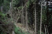
Title (German)
Schleuis GR, Wald südlich von Schallas im Westhang des Val da Schluein
Caption
Structure of polewood stand (spruce), first photograph before thinning in 1997, partial view; coordinates (LV03) of camera location: 73517f/18460f; keywords Documenta Natura: mountain forest, thinning.
Caption (German)
Struktur des Stangenholzbestandes (Fichte), Erstaufnahme vor der Durchforstung 1997, Teilansicht; Koordinaten (LV03) des Kamerastandorts: 73517f/18460f; Schlagworte Documenta Natura: Gebirgswald, Durchforstung
Record Name
Dia_303-24372

Title (German)
Schleuis GR, Wald südlich von Schallas im Westhang des Val da Schluein
Caption
Structure of polewood stand (spruce), first photograph before thinning in 1997, partial view; coordinates (LV03) of camera location: 73517f/18460f; keywords Documenta Natura: mountain forest, thinning.
Caption (German)
Struktur des Stangenholzbestandes (Fichte), Erstaufnahme vor der Durchforstung 1997, Teilansicht; Koordinaten (LV03) des Kamerastandorts: 73517f/18460f; Schlagworte Documenta Natura: Gebirgswald, Durchforstung
Record Name
Dia_303-24382

Title (German)
Brienz/Brinzauls GR, In der Rutschung Igl Rutsch im Südhang oberhalb Brienz
Caption
Scree slope of the landslide Igl Rutsch, with loose trees, partial view upslope; coordinates (LV03) of the camera location: 765080/171500; keywords Documenta Natura: landslide
Caption (German)
Geröllhalde der Rutschung Igl Rutsch, mit lockerem Baumbestand, Teilansicht hangaufwärts; Koordinaten (LV03) des Kamerastandorts: 765080/171500; Schlagworte Documenta Natura: Rutschung
Record Name
Dia_303-24459

Title (German)
Brienz/Brinzauls GR, In der Rutschung Igl Rutsch im Südhang oberhalb Brienz
Caption
Scree slope of the landslide Igl Rutsch, with loose trees, partial view upslope; coordinates (LV03) of the camera location: 765080/171500; keywords Documenta Natura: landslide
Caption (German)
Geröllhalde der Rutschung Igl Rutsch, mit lockerem Baumbestand, Teilansicht hangaufwärts; Koordinaten (LV03) des Kamerastandorts: 765080/171500; Schlagworte Documenta Natura: Rutschung
Record Name
Dia_303-24466

Title (German)
Brienz/Brinzauls GR, Bei den Weilern Plang Turigns (1) und Propissi Sot (2-10)
Caption
Old and decayed stone channels on mountain meadow, photograph 1991, partial view; keywords Documenta Natura: landslide.
Caption (German)
Alte und zerfallene Steinkanäle auf Bergwiese, Aufnahme 1991, Teilansicht; Schlagworte Documenta Natura: Rutschung
Record Name
Dia_303-24480

Title (German)
Brienz/Brinzauls GR, Bei den Weilern Plang Turigns (1) und Propissi Sot (2-10)
Caption
Old and decayed stone channels on mountain meadow, photo 1995, general view; keywords Documenta Natura: landslide
Caption (German)
Alte und zerfallene Steinkanäle auf Bergwiese, Aufnahme 1995, Gesamtansicht; Schlagworte Documenta Natura: Rutschung
Record Name
Dia_303-24481

Title (German)
Brienz/Brinzauls GR, Bei den Weilern Plang Turigns (1) und Propissi Sot (2-10)
Caption
Old and decayed stone channels on mountain meadow, photograph 1995, partial view; keywords Documenta Natura: landslide.
Caption (German)
Alte und zerfallene Steinkanäle auf Bergwiese, Aufnahme 1995, Teilansicht; Schlagworte Documenta Natura: Rutschung
Record Name
Dia_303-24484

Title (German)
Brienz/Brinzauls GR, Bei den Weilern Plang Turigns (1) und Propissi Sot (2-10)
Caption
Small catch basin with water shaft (dole) on mountain meadow, photo 1995, partial view; keywords Documenta Natura: landslide
Caption (German)
Kleines Auffangbecken mit Wasserschacht (Dole) auf Bergwiese, Aufnahme 1995, Teilansicht; Schlagworte Documenta Natura: Rutschung
Record Name
Dia_303-24487
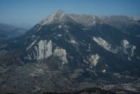
Title (German)
Brienz/Brinzauls GR, Südansicht von Brienz mit Südhang und Piz Linard
Caption
South view of Brienz with pastureland, farmland, scrub forest, hedges, protective forest, the landslide Igl Rutsch, the alpine pastures Propissi Sot, Propissi Saura and Schautschen, the avalanche train Arsa Pintga, drainage canal and the Piz Linard, first photograph 1989, reverse slope photograph, general view; coordinates (LV03) of the camera location: 765878/167835; keywords Documenta Natura: landslide
Caption (German)
Südansicht von Brienz mit Weidland, Ackerland, Gebüschwald, Hecken, Schutzwald, der Rutschung Igl Rutsch, den Alpweiden Propissi Sot, Propissi Saura und Schautschen, des Lawinenzuges Arsa Pintga, Entwässerungskanal und dem Piz Linard, Erstaufnahme 1989, Gegenhangaufnahme, Gesamtansicht; Koordinaten (LV03) des Kamerastandorts: 765878/167835; Schlagworte Documenta Natura: Rutschung
Record Name
Dia_303-24494

Title (German)
Brienz/Brinzauls GR, Südansicht von Brienz mit Südhang und Piz Linard
Caption
South view of Brienz with pastureland, farmland, scrub forest, hedges, protective forest, the landslide Igl Rutsch, the alpine pastures Propissi Sot, Propissi Saura and Schautschen, the avalanche train Arsa Pintga, drainage canal and the Piz Linard, first photograph 1989, reverse slope photograph, general view; coordinates (LV03) of the camera location: 765878/167835; keywords Documenta Natura: landslide
Caption (German)
Südansicht von Brienz mit Weidland, Ackerland, Gebüschwald, Hecken, Schutzwald, der Rutschung Igl Rutsch, den Alpweiden Propissi Sot, Propissi Saura und Schautschen, des Lawinenzuges Arsa Pintga, Entwässerungskanal und dem Piz Linard, Erstaufnahme 1989, Gegenhangaufnahme, Gesamtansicht; Koordinaten (LV03) des Kamerastandorts: 765878/167835; Schlagworte Documenta Natura: Rutschung
Record Name
Dia_303-24497

Title (German)
Brienz/Brinzauls GR, Südansicht von Brienz mit Südhang und Piz Linard
Caption
South view of Brienz with pastureland, farmland, scrub forest, hedges, protective forest, the landslide Igl Rutsch, the alpine pastures Propissi Sot, Propissi Saura and Schautschen, the avalanche train Arsa Pintga, first photograph 1989, reverse slope photograph, general view; coordinates (LV03) of the camera location: 765878/167835; keywords Documenta Natura: landslide
Caption (German)
Südansicht von Brienz mit Weidland, Ackerland, Gebüschwald, Hecken, Schutzwald, der Rutschung Igl Rutsch, den Alpweiden Propissi Sot, Propissi Saura und Schautschen, des Lawinenzuges Arsa Pintga, Erstaufnahme 1989, Gegenhangaufnahme, Gesamtansicht; Koordinaten (LV03) des Kamerastandorts: 765878/167835; Schlagworte Documenta Natura: Rutschung
Record Name
Dia_303-24500

Title (German)
Brienz/Brinzauls GR, Südansicht von Brienz mit Südhang und Piz Linard
Caption
South view of Brienz with pastureland, farmland, scrub forest, hedges, protective forest, the landslide Igl Rutsch, the alpine pastures Propissi Sot, Propissi Saura and Schautschen, the avalanche train Arsa Pintga, first photograph 1989, reverse slope photograph, general view; coordinates (LV03) of the camera location: 765878/167835; keywords Documenta Natura: landslide
Caption (German)
Südansicht von Brienz mit Weidland, Ackerland, Gebüschwald, Hecken, Schutzwald, der Rutschung Igl Rutsch, den Alpweiden Propissi Sot, Propissi Saura und Schautschen, des Lawinenzuges Arsa Pintga, Erstaufnahme 1989, Gegenhangaufnahme, Gesamtansicht; Koordinaten (LV03) des Kamerastandorts: 765878/167835; Schlagworte Documenta Natura: Rutschung
Record Name
Dia_303-24503

Title (German)
Brienz/Brinzauls GR, Südansicht von Brienz mit Südhang und Piz Linard
Caption
South view of Brienz with pastureland, farmland, scrub forest, hedges, protective forest, the Igl Rutsch landslide, first photograph 1989, reverse slope photograph, general view; coordinates (LV03) of the camera location: 765878/167835; keywords Documenta Natura: landslide
Caption (German)
Südansicht von Brienz mit Weidland, Ackerland, Gebüschwald, Hecken, Schutzwald, der Rutschung Igl Rutsch, Erstaufnahme 1989, Gegenhangaufnahme, Gesamtansicht; Koordinaten (LV03) des Kamerastandorts: 765878/167835; Schlagworte Documenta Natura: Rutschung
Record Name
Dia_303-24506

Title (German)
Brienz/Brinzauls GR, Südansicht von Brienz mit Südhang und Piz Linard
Caption
South view of Brienz with pastureland, farmland, scrub forest, hedges, protective forest, the landslide Igl Rutsch, the alpine pastures Propissi Sot, Propissi Saura and Schautschen, the avalanche train Arsa Pintga, drainage canal and Piz Linard, 1st follow-up image 1991, reverse slope image, general view; coordinates (LV03) of the camera location: 765878/167835; keywords Documenta Natura: landslide
Caption (German)
Südansicht von Brienz mit Weidland, Ackerland, Gebüschwald, Hecken, Schutzwald, der Rutschung Igl Rutsch, den Alpweiden Propissi Sot, Propissi Saura und Schautschen, des Lawinenzuges Arsa Pintga, Entwässerungskanal und dem Piz Linard, 1. Folgeaufnahme 1991, Gegenhangaufnahme, Gesamtansicht; Koordinaten (LV03) des Kamerastandorts: 765878/167835; Schlagworte Documenta Natura: Rutschung
Record Name
Dia_303-24509

Title (German)
Brienz/Brinzauls GR, Südansicht von Brienz mit Südhang und Piz Linard
Caption
South view of Brienz with pastureland, farmland, scrub forest, hedges, protective forest, the landslide Igl Rutsch, the alpine pastures Propissi Sot, Propissi Saura and Schautschen, the avalanche train Arsa Pintga, drainage canal and Piz Linard, 1st follow-up image 1991, reverse slope image, general view; coordinates (LV03) of the camera location: 765878/167835; keywords Documenta Natura: landslide
Caption (German)
Südansicht von Brienz mit Weidland, Ackerland, Gebüschwald, Hecken, Schutzwald, der Rutschung Igl Rutsch, den Alpweiden Propissi Sot, Propissi Saura und Schautschen, des Lawinenzuges Arsa Pintga, Entwässerungskanal und dem Piz Linard, 1. Folgeaufnahme 1991, Gegenhangaufnahme, Gesamtansicht; Koordinaten (LV03) des Kamerastandorts: 765878/167835; Schlagworte Documenta Natura: Rutschung
Record Name
Dia_303-24513

Title (German)
Brienz/Brinzauls GR, Südansicht von Brienz mit Südhang und Piz Linard
Caption
South view of Brienz with pastureland, farmland, scrub forest, hedges, protective forest, the landslide Igl Rutsch, the alpine pastures Propissi Sot, Propissi Saura and Schautschen, the avalanche train Arsa Pintga, 1st follow-up image 1991, reverse slope image, general view; coordinates (LV03) of the camera location: 765878/167835; keywords Documenta Natura: landslide
Caption (German)
Südansicht von Brienz mit Weidland, Ackerland, Gebüschwald, Hecken, Schutzwald, der Rutschung Igl Rutsch, den Alpweiden Propissi Sot, Propissi Saura und Schautschen, des Lawinenzuges Arsa Pintga, 1. Folgeaufnahme 1991, Gegenhangaufnahme, Gesamtansicht; Koordinaten (LV03) des Kamerastandorts: 765878/167835; Schlagworte Documenta Natura: Rutschung
Record Name
Dia_303-24518

Title (German)
Brienz/Brinzauls GR, Südansicht von Brienz mit Südhang und Piz Linard
Caption
South view of Brienz with pastureland, arable land, scrub forest, hedges, protective forest, the landslide Igl Rutsch, the alpine pastures Propissi Sot, Propissi Saura and Schautschen, 1st follow-up photo 1991, reverse slope photo, general view; coordinates (LV03) of the camera location: 765878/167835; keywords Documenta Natura: landslide
Caption (German)
Südansicht von Brienz mit Weidland, Ackerland, Gebüschwald, Hecken, Schutzwald, der Rutschung Igl Rutsch, den Alpweiden Propissi Sot, Propissi Saura und Schautschen, 1. Folgeaufnahme 1991, Gegenhangaufnahme, Gesamtansicht; Koordinaten (LV03) des Kamerastandorts: 765878/167835; Schlagworte Documenta Natura: Rutschung
Record Name
Dia_303-24521

Title (German)
Brienz/Brinzauls GR, Südansicht von Brienz mit Südhang und Piz Linard
Caption
South view of Brienz with pastureland, farmland, scrub forest, hedges, protective forest, the Igl Rutsch landslide, 2nd follow-up image 1995, reverse slope image, general view; coordinates (LV03) of the camera location: 766080/169500; keywords Documenta Natura: landslide
Caption (German)
Südansicht von Brienz mit Weidland, Ackerland, Gebüschwald, Hecken, Schutzwald, der Rutschung Igl Rutsch, 2. Folgeaufnahme 1995, Gegenhangaufnahme, Gesamtansicht; Koordinaten (LV03) des Kamerastandorts: 766080/169500; Schlagworte Documenta Natura: Rutschung
Record Name
Dia_303-24524

Title (German)
Brienz/Brinzauls GR, Südansicht von Brienz mit Südhang und Piz Linard
Caption
South view of Brienz with pastureland, farmland, scrub forest, hedges, protective forest, the Igl Rutsch landslide, 2nd follow-up image 1995, reverse slope image, general view; coordinates (LV03) of the camera location: 766080/169500; keywords Documenta Natura: landslide
Caption (German)
Südansicht von Brienz mit Weidland, Ackerland, Gebüschwald, Hecken, Schutzwald, der Rutschung Igl Rutsch, 2. Folgeaufnahme 1995, Gegenhangaufnahme, Gesamtansicht; Koordinaten (LV03) des Kamerastandorts: 766080/169500; Schlagworte Documenta Natura: Rutschung
Record Name
Dia_303-24529

Title (German)
Brienz/Brinzauls GR, Südansicht von Brienz mit Südhang und Piz Linard
Caption
South view of Brienz with pastureland, farmland, scrub forest, hedgerows, protective forest, foot of the Igl Rutsch landslide, photo taken in 1995, reverse slope photo, general view, 2nd follow-up photo; coordinates (LV03) of the camera location: 766080/169500; keywords Documenta Natura: landslide
Caption (German)
Südansicht von Brienz mit Weidland, Ackerland, Gebüschwald, Hecken, Schutzwald, Fuss der Rutschung Igl Rutsch, Aufnahme 1995, Gegenhangaufnahme, Gesamtansicht, 2. Folgeaufnahme; Koordinaten (LV03) des Kamerastandorts: 766080/169500; Schlagworte Documenta Natura: Rutschung
Record Name
Dia_303-24533

Title (German)
Brienz/Brinzauls GR, Südansicht von Brienz mit Südhang und Piz Linard
Caption
East view of the Igl Rutsch landslide, with rocky outcrop and protective forest, photo taken in 1995, counter-slope photo, general view; coordinates (LV03) of camera location: 766080/169500; keywords Documenta Natura: landslide.
Caption (German)
Ostansicht der Rutschung Igl Rutsch, mit Felsabbruch und Schutzwald, Aufnahme 1995, Gegenhangaufnahme, Gesamtansicht; Koordinaten (LV03) des Kamerastandorts: 766080/169500; Schlagworte Documenta Natura: Rutschung
Record Name
Dia_303-24537

Title (German)
Brienz/Brinzauls GR, Südansicht von Brienz mit Südhang und Piz Linard
Caption
East view of the Igl Rutsch landslide, with rocky outcrop and protective forest, photo taken in 1995, counter-slope photo, general view; coordinates (LV03) of camera location: 766080/169500; keywords Documenta Natura: landslide.
Caption (German)
Ostansicht der Rutschung Igl Rutsch, mit Felsabbruch und Schutzwald, Aufnahme 1995, Gegenhangaufnahme, Gesamtansicht; Koordinaten (LV03) des Kamerastandorts: 766080/169500; Schlagworte Documenta Natura: Rutschung
Record Name
Dia_303-24541

Title (German)
Brienz/Brinzauls GR, Südansicht von Brienz mit Südhang und Piz Linard
Caption
Rock slope with landslide, east of Brienz/GR, with castle ruins, photo taken in 1995, counter-slope photo, general view; coordinates (LV03) of camera location: 766080/169500; keywords Documenta Natura: landslide
Caption (German)
Felsabbruch mit Rutschung, östlich von Brienz/GR, mit Burgruine, Aufnahme 1995, Gegenhangaufnahme, Gesamtansicht; Koordinaten (LV03) des Kamerastandorts: 766080/169500; Schlagworte Documenta Natura: Rutschung
Record Name
Dia_303-24545
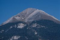
Title (German)
Brienz/Brinzauls GR, Südansicht von Brienz mit Südhang und Piz Linard
Caption
South view of Piz Linard with drainage channel and protective forest, photo taken in 1995, counter-slope photo, general view; coordinates (LV03) of camera location: 766080/169500; keywords Documenta Natura: landslide
Caption (German)
Südansicht des Piz Linard mit Entwässerungskanal und Schutzwald, Aufnahme 1995, Gegenhangaufnahme, Gesamtansicht; Koordinaten (LV03) des Kamerastandorts: 766080/169500; Schlagworte Documenta Natura: Rutschung
Record Name
Dia_303-24549

Title (German)
Brienz/Brinzauls GR, Südansicht des Südhanges mit dem Brienzer Rutsch oberhalb des Dorfes Brienz
Caption
South view of the southern slope with landslide (Brienzer Rutsch), in the foreground meadowland, stable and protective dam, first photograph 1989, general view; coordinates (LV03) of the camera location: 764800/170900; keywords Documenta Natura: landslide
Caption (German)
Südansicht des Südhanges mit Rutschung (Brienzer Rutsch), im Vordergrund Wiesland, Stall und Schutzdamm, Erstaufnahme 1989, Gesamtansicht; Koordinaten (LV03) des Kamerastandorts: 764800/170900; Schlagworte Documenta Natura: Rutschung
Record Name
Dia_303-24552

Title (German)
Brienz/Brinzauls GR, Südansicht des Südhanges mit dem Brienzer Rutsch oberhalb des Dorfes Brienz
Caption
South view of the southern slope with landslide (Brienzer Rutsch), in the foreground meadowland, stable and protective dam, first photograph 1989, general view; coordinates (LV03) of the camera location: 764800/170900; keywords Documenta Natura: landslide
Caption (German)
Südansicht des Südhanges mit Rutschung (Brienzer Rutsch), im Vordergrund Wiesland, Stall und Schutzdamm, Erstaufnahme 1989, Gesamtansicht; Koordinaten (LV03) des Kamerastandorts: 764800/170900; Schlagworte Documenta Natura: Rutschung
Record Name
Dia_303-24555

Title (German)
Brienz/Brinzauls GR, Südansicht des Südhanges mit dem Brienzer Rutsch oberhalb des Dorfes Brienz
Caption
South view of the southern slope with landslide (Brienzer Rutsch), in the foreground meadowland, stable and protective dam, 1st follow-up photograph 1990, general view; coordinates (LV03) of the camera location: 764800/170900; keywords Documenta Natura: landslide
Caption (German)
Südansicht des Südhanges mit Rutschung (Brienzer Rutsch), im Vordergrund Wiesland, Stall und Schutzdamm, 1. Folgeaufnahme 1990, Gesamtansicht; Koordinaten (LV03) des Kamerastandorts: 764800/170900; Schlagworte Documenta Natura: Rutschung
Record Name
Dia_303-24559

Title (German)
Brienz/Brinzauls GR, Südansicht des Südhanges mit dem Brienzer Rutsch oberhalb des Dorfes Brienz
Caption
South view of the southern slope with landslide (Brienzer Rutsch), in the foreground meadowland, stable and protective dam, 1st follow-up photograph 1990, general view; coordinates (LV03) of the camera location: 764800/170900; keywords Documenta Natura: landslide
Caption (German)
Südansicht des Südhanges mit Rutschung (Brienzer Rutsch), im Vordergrund Wiesland, Stall und Schutzdamm, 1. Folgeaufnahme 1990, Gesamtansicht; Koordinaten (LV03) des Kamerastandorts: 764800/170900; Schlagworte Documenta Natura: Rutschung
Record Name
Dia_303-24565

Title (German)
Brienz/Brinzauls GR, Südansicht des Südhanges mit dem Brienzer Rutsch oberhalb des Dorfes Brienz
Caption
South view of the southern slope with landslide (Brienzer Rutsch), first image 1990, partial view; coordinates (LV03) of the camera location: 764800/170900; keywords Documenta Natura: landslide
Caption (German)
Südansicht des Südhanges mit Rutschung (Brienzer Rutsch), Erstaufnahme 1990, Teilansicht; Koordinaten (LV03) des Kamerastandorts: 764800/170900; Schlagworte Documenta Natura: Rutschung
Record Name
Dia_303-24569

Title (German)
Brienz/Brinzauls GR, Südansicht des Südhanges mit dem Brienzer Rutsch oberhalb des Dorfes Brienz
Caption
South view of the southern slope with landslide (Brienzer Rutsch), in the foreground meadowland, stable and protective dam, photograph taken in 1990, general view; coordinates (LV03) of camera location: 764800/170900; keywords Documenta Natura: landslide
Caption (German)
Südansicht des Südhanges mit Rutschung (Brienzer Rutsch), im Vordergrund Wiesland, Stall und Schutzdamm, Aufnahme 1990, Gesamtansicht; Koordinaten (LV03) des Kamerastandorts: 764800/170900; Schlagworte Documenta Natura: Rutschung
Record Name
Dia_303-24572

Title (German)
Brienz/Brinzauls GR, Dämme nordwestlich von Brienz mit Südhang
Caption
South view of the protective dam with southern slope, landslide and ban forest, general view; keywords Documenta Natura: landslide.
Caption (German)
Südansicht des Schutzdammes mit Südhang, Rutschung und Bannwald, Gesamtansicht; Schlagworte Documenta Natura: Rutschung
Record Name
Dia_303-24596
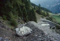
Title (German)
Brienz/Brinzauls GR, Dämme nordwestlich von Brienz mit Südhang
Caption
Dam with collected stones and boulders, partial ban forest and landslide in the background, partial view; keywords Documenta Natura: landslide.
Caption (German)
Damm mit aufgefangenen Steinen und Felsblöcken, teilweise Bannwald und Rutschung im Hintergrund, Teilansicht; Schlagworte Documenta Natura: Rutschung
Record Name
Dia_303-24599

Title (German)
Brienz/Brinzauls GR, Dämme nordwestlich von Brienz mit Südhang
Caption
Close-up dam with caught boulder, partial view; keywords Documenta Natura: landslide.
Caption (German)
Nahaufnahme Damm mit aufgefangenem Felsblock, Teilansicht; Schlagworte Documenta Natura: Rutschung
Record Name
Dia_303-24602

Title (German)
Brienz/Brinzauls GR, Dämme nordwestlich von Brienz mit Südhang
Caption
Slope to the dam with collected stones and boulders, ban forest and landslide in the background, general view; keywords Documenta Natura: landslide.
Caption (German)
Hang zum Damm mit aufgefangenen Steinen und Felsblöcken, Bannwald und Rutschung im Hintergrund, Gesamtansicht; Schlagworte Documenta Natura: Rutschung
Record Name
Dia_303-24605

Title (German)
Brienz/Brinzauls GR, Dämme nordwestlich von Brienz mit Südhang
Caption
Dam with catch basin, held up stones and boulders, ban forest in the background, general view; keywords Documenta Natura: landslide
Caption (German)
Damm mit Auffangbecken, aufgehaltene Steine und Felsblöcke, Bannwald im Hintergrund, Gesamtansicht; Schlagworte Documenta Natura: Rutschung
Record Name
Dia_303-24608

Title (German)
Brienz/Brinzauls GR, Dämme nordwestlich von Brienz mit Südhang
Caption
Dam with catch basin, held up stones and boulders, ban forest in the background, partial view; keywords Documenta Natura: landslide
Caption (German)
Damm mit Auffangbecken, aufgehaltene Steine und Felsblöcke, Bannwald im Hintergrund, Teilansicht; Schlagworte Documenta Natura: Rutschung
Record Name
Dia_303-24611

Title (German)
Brienz/Brinzauls GR, Dämme nordwestlich von Brienz mit Südhang
Caption
View from the dam uphill towards the landslide, partial view; keywords Documenta Natura: landslide
Caption (German)
Blick vom Damm hangaufwärts Richtung Rutschung, Teilansicht; Schlagworte Documenta Natura: Rutschung
Record Name
Dia_303-24614

Title (German)
Brienz/Brinzauls GR, Im Föhrenwald oberhalb des Weilers Pigni
Caption
Structure of the pine forest with natural regeneration, partial view along the forest road; keywords Documenta Natura: landslide.
Caption (German)
Struktur des Föhrenwaldes mit Naturverjüngung, Teilansicht entlang der Waldstrasse; Schlagworte Documenta Natura: Rutschung
Record Name
Dia_303-24616

Title (German)
Brienz/Brinzauls GR, Im Föhrenwald oberhalb des Weilers Pigni
Caption
Structure of pine forest with natural regeneration, pines partially pushed by snow pressure, snow sliding, partial view across the slope; keywords Documenta Natura: landslide.
Caption (German)
Struktur des Föhrenwaldes mit Naturverjüngung, teilweise durch Schneedruck, Schneegleiten gestossene Föhren, Teilansicht quer zum Hang; Schlagworte Documenta Natura: Rutschung
Record Name
Dia_303-24618

Title (German)
Brienz/Brinzauls GR, Im Föhrenwald oberhalb des Weilers Pigni
Caption
Structure of pine forest with natural regeneration, partial view; keywords Documenta Natura: landslide.
Caption (German)
Struktur des Föhrenwaldes mit Naturverjüngung, Teilansicht; Schlagworte Documenta Natura: Rutschung
Record Name
Dia_303-24621

Title (German)
Brienz/Brinzauls GR, Im Föhrenwald oberhalb des Weilers Pigni
Caption
Structure of pine forest with natural regeneration, pines partially pushed by snow pressure, snow sliding, general view upslope ; keywords Documenta Natura: landslide.
Caption (German)
Struktur des Föhrenwaldes mit Naturverjüngung, teilweise durch Schneedruck, Schneegleiten gestossene Föhren, Gesamtansicht hangaufwärts ; Schlagworte Documenta Natura: Rutschung
Record Name
Dia_303-24624

Title (German)
Brienz/Brinzauls GR, Im Föhrenwald oberhalb des Weilers Pigni
Caption
Structure of pine forest with natural regeneration, pines partially pushed by snow pressure, snow sliding, partial view across the slope; keywords Documenta Natura: landslide.
Caption (German)
Struktur des Föhrenwaldes mit Naturverjüngung, teilweise durch Schneedruck, Schneegleiten gestossene Föhren, Teilansicht quer zum Hang; Schlagworte Documenta Natura: Rutschung
Record Name
Dia_303-24628

Title (German)
Brienz/Brinzauls GR, Im Föhrenwald oberhalb des Weilers Pigni
Caption
Structure of pine forest with natural regeneration, pines partially pushed by snow pressure, snow sliding, partial view across the slope; keywords Documenta Natura: landslide.
Caption (German)
Struktur des Föhrenwaldes mit Naturverjüngung, teilweise durch Schneedruck, Schneegleiten gestossene Föhren, Teilansicht quer zum Hang; Schlagworte Documenta Natura: Rutschung
Record Name
Dia_303-24630
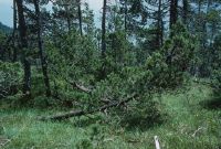
Title (German)
Brienz/Brinzauls GR, Im Föhrenwald oberhalb des Weilers Pigni
Caption
Structure of pine forest with natural regeneration, pines partially pushed by snow pressure, snow sliding, partial view across the slope; keywords Documenta Natura: landslide.
Caption (German)
Struktur des Föhrenwaldes mit Naturverjüngung, teilweise durch Schneedruck, Schneegleiten gestossene Föhren, Teilansicht quer zum Hang; Schlagworte Documenta Natura: Rutschung
Record Name
Dia_303-24638

Title (German)
Brienz/Brinzauls GR, Im Föhrenwald oberhalb des Weilers Pigni
Caption
Structure of pine forest with natural regeneration, pines partially pushed by snow pressure, snow sliding, partial view across the slope; keywords Documenta Natura: landslide.
Caption (German)
Struktur des Föhrenwaldes mit Naturverjüngung, teilweise durch Schneedruck, Schneegleiten gestossene Föhren, Teilansicht quer zum Hang; Schlagworte Documenta Natura: Rutschung
Record Name
Dia_303-24642

Title (German)
Brienz/Brinzauls GR, Südhang unterhalb des Piz Linard
Caption
Open main channel on the southern slope of Piz Linard, photograph taken in 1989, partial view upslope; keywords Documenta Natura: landslide.
Caption (German)
Offener Hauptkanal auf dem Südhang des Piz Linard, Aufnahme 1989, Teilansicht hangaufwärts; Schlagworte Documenta Natura: Rutschung
Record Name
Dia_303-24644

Title (German)
Brienz/Brinzauls GR, Südhang unterhalb des Piz Linard
Caption
Open main channel on the southern slope of Piz Linard, photograph taken in 1989, partial view downslope; keywords Documenta Natura: landslide.
Caption (German)
Offener Hauptkanal auf dem Südhang des Piz Linard, Aufnahme 1989, Teilansicht hangabwärts; Schlagworte Documenta Natura: Rutschung
Record Name
Dia_303-24650

Title (German)
Brienz/Brinzauls GR, Südhang unterhalb des Piz Linard
Caption
South view of the southern slope below Piz Linard with avalanche train and small landslides in the forest, photo taken in 1991, counter-slope photo, general view; coordinates (LV03) of the camera location: 765878/167835; keywords Documenta Natura: landslide
Caption (German)
Südansicht des Südhanges unterhalb des Piz Linard mit Lawinenzug und kleinen Rutschungen im Wald, Aufnahme 1991, Gegenhangaufnahme, Gesamtansicht; Koordinaten (LV03) des Kamerastandorts: 765878/167835; Schlagworte Documenta Natura: Rutschung
Record Name
Dia_303-24654

Title (German)
Brienz/Brinzauls GR, Im Lawinenzug Arsa Pintga westlich von Pigni
Caption
Avalanche train with leg pine, Dürrholz on the ground, partial view; keywords Documenta Natura: landslide
Caption (German)
Lawinenzug mit Legföhre, Dürrholz am Boden, Teilansicht; Schlagworte Documenta Natura: Rutschung
Record Name
Dia_303-24657

Title (German)
Brienz/Brinzauls GR, Im Lawinenzug Arsa Pintga westlich von Pigni
Caption
Avalanche train with leg pine, Dürrholz on the ground, partial view; keywords Documenta Natura: landslide
Caption (German)
Lawinenzug mit Legföhre, Dürrholz am Boden, Teilansicht; Schlagworte Documenta Natura: Rutschung
Record Name
Dia_303-24659

Title (German)
Brienz/Brinzauls GR, Im Lawinenzug Arsa Pintga westlich von Pigni
Caption
Avalanche train with leg pine, Dürrholz at the bottom, general view downslope; keywords Documenta Natura: landslide
Caption (German)
Lawinenzug mit Legföhre, Dürrholz am Boden, Gesamtansicht hangabwärts; Schlagworte Documenta Natura: Rutschung
Record Name
Dia_303-24662

Title (German)
Brienz/Brinzauls GR, Im Lawinenzug Arsa Pintga westlich von Pigni
Caption
Avalanche train with leg pine, drought wood at the bottom, general view across the slope; keywords Documenta Natura: landslide
Caption (German)
Lawinenzug mit Legföhre, Dürrholz am Boden, Gesamtansicht quer zum Hang; Schlagworte Documenta Natura: Rutschung
Record Name
Dia_303-24665

Title (German)
Brienz/Brinzauls GR, Im Lawinenzug Arsa Pintga westlich von Pigni
Caption
Avalanche train with leg pine, Dürrholz on the ground, partial view upslope; keywords Documenta Natura: landslide
Caption (German)
Lawinenzug mit Legföhre, Dürrholz am Boden, Teilansicht hangaufwärts; Schlagworte Documenta Natura: Rutschung
Record Name
Dia_303-24669

Title (German)
Brienz/Brinzauls GR, Im Lawinenzug Arsa Pintga westlich von Pigni
Caption
Avalanche train with leg pine, Dürrholz on the ground, partial view upslope; keywords Documenta Natura: landslide
Caption (German)
Lawinenzug mit Legföhre, Dürrholz am Boden, Teilansicht hangaufwärts; Schlagworte Documenta Natura: Rutschung
Record Name
Dia_303-24672

Title (German)
Brienz/Brinzauls GR, Im Lawinenzug Arsa Pintga westlich von Pigni
Caption
Avalanche train with leg pine, drought wood at the bottom, general view across the slope; keywords Documenta Natura: landslide
Caption (German)
Lawinenzug mit Legföhre, Dürrholz am Boden, Gesamtansicht quer zum Hang; Schlagworte Documenta Natura: Rutschung
Record Name
Dia_303-24675

Title (German)
Brienz/Brinzauls GR, Im Lawinenzug Arsa Pintga westlich von Pigni
Caption
Avalanche train with leg pine, Dürrholz at the bottom, general view downslope; keywords Documenta Natura: landslide
Caption (German)
Lawinenzug mit Legföhre, Dürrholz am Boden, Gesamtansicht hangabwärts; Schlagworte Documenta Natura: Rutschung
Record Name
Dia_303-24678

Title (German)
Brienz/Brinzauls GR, Blick (Südostansicht) auf das Dorf Brienz mit Wiesland Igl Plax und Rutschung Igl Rutsch
Caption
Southeast view of the village of Brienz with meadowland, hedges and shrub forest Igl Plax, protective forest and landslide Igl Rutsch, first photograph 1991, reverse slope photograph, general view; coordinates (LV03) of camera location: 766336/169761; keywords Documenta Natura: landslide
Caption (German)
Südostansicht auf das Dorf Brienz mit Wiesland, Hecken und Gebüschwald Igl Plax, Schutzwald und Rutschung Igl Rutsch, Erstaufnahme 1991, Gegenhangaufnahme, Gesamtansicht; Koordinaten (LV03) des Kamerastandorts: 766336/169761; Schlagworte Documenta Natura: Rutschung
Record Name
Dia_303-24682

Title (German)
Brienz/Brinzauls GR, Blick (Südostansicht) auf das Dorf Brienz mit Wiesland Igl Plax und Rutschung Igl Rutsch
Caption
Southeast view of the village of Brienz with meadowland, hedges and scrub forest Igl Plax, protective forest and landslide Igl Rutsch, 1st follow-up photograph 1992, reverse slope photograph, partial view; coordinates (LV03) of camera location: 766336/169761; keywords Documenta Natura: landslide
Caption (German)
Südostansicht auf das Dorf Brienz mit Wiesland, Hecken und Gebüschwald Igl Plax, Schutzwald und Rutschung Igl Rutsch, 1. Folgeaufnahme 1992, Gegenhangaufnahme, Teilansicht; Koordinaten (LV03) des Kamerastandorts: 766336/169761; Schlagworte Documenta Natura: Rutschung
Record Name
Dia_303-24687

Title (German)
Brienz/Brinzauls GR, Blick (Südostansicht) auf das Dorf Brienz mit Wiesland Igl Plax und Rutschung Igl Rutsch
Caption
Southeast view of the village of Brienz with meadowland, hedges and scrub forest Igl Plax, protective forest and landslide Igl Rutsch, 1st follow-up photograph 1992, reverse slope photograph, partial view; coordinates (LV03) of camera location: 766336/169761; keywords Documenta Natura: landslide
Caption (German)
Südostansicht auf das Dorf Brienz mit Wiesland, Hecken und Gebüschwald Igl Plax, Schutzwald und Rutschung Igl Rutsch, 1. Folgeaufnahme 1992, Gegenhangaufnahme, Teilansicht; Koordinaten (LV03) des Kamerastandorts: 766336/169761; Schlagworte Documenta Natura: Rutschung
Record Name
Dia_303-24690

Title (German)
Brienz/Brinzauls GR, Ostansicht des Südhanges mit dem Brienzer Rutsch, Igl Rutsch oberhalb des Dorfes Brienz
Caption
East view of the southern slope with the Brienzer Rutsch, Igl Rutsch, first photo taken in 1991, partial view across the slope; coordinates (LV03) of the camera location: 765420/171620; keywords Documenta Natura: landslide
Caption (German)
Ostansicht des Südhanges mit dem Brienzer Rutsch, Igl Rutsch, Erstaufnahme 1991, Teilansicht quer zum Hang; Koordinaten (LV03) des Kamerastandorts: 765420/171620; Schlagworte Documenta Natura: Rutschung
Record Name
Dia_303-24702

Title (German)
Brienz/Brinzauls GR, Ostansicht des Südhanges mit dem Brienzer Rutsch, Igl Rutsch oberhalb des Dorfes Brienz
Caption
East view of the southern slope with the Brienzer Rutsch, Igl Rutsch, photo taken in 1991, partial view across the slope; coordinates (LV03) of the camera location: 765420/171620; keywords Documenta Natura: landslide
Caption (German)
Ostansicht des Südhanges mit dem Brienzer Rutsch, Igl Rutsch, Aufnahme 1991, Teilansicht quer zum Hang; Koordinaten (LV03) des Kamerastandorts: 765420/171620; Schlagworte Documenta Natura: Rutschung
Record Name
Dia_303-24705

Title (German)
Brienz/Brinzauls GR, Ostansicht des Südhanges mit dem Brienzer Rutsch, Igl Rutsch oberhalb des Dorfes Brienz
Caption
East view of the southern slope with the Brienzer Rutsch, Igl Rutsch, photo taken in 1991, partial view across the slope; coordinates (LV03) of the camera location: 765420/171620; keywords Documenta Natura: landslide
Caption (German)
Ostansicht des Südhanges mit dem Brienzer Rutsch, Igl Rutsch, Aufnahme 1991, Teilansicht quer zum Hang; Koordinaten (LV03) des Kamerastandorts: 765420/171620; Schlagworte Documenta Natura: Rutschung
Record Name
Dia_303-24709

Title (German)
Brienz/Brinzauls GR, Ostansicht des Südhanges mit dem Brienzer Rutsch, Igl Rutsch oberhalb des Dorfes Brienz
Caption
East view of the southern slope with the Brienzer Rutsch, Igl Rutsch, photo taken in 1991, partial view across the slope; coordinates (LV03) of the camera location: 765420/171620; keywords Documenta Natura: landslide
Caption (German)
Ostansicht des Südhanges mit dem Brienzer Rutsch, Igl Rutsch, Aufnahme 1991, Teilansicht quer zum Hang; Koordinaten (LV03) des Kamerastandorts: 765420/171620; Schlagworte Documenta Natura: Rutschung
Record Name
Dia_303-24711

Title (German)
Brienz/Brinzauls GR, Abrisskante unterhalb Propissi Sot
Caption
Steep, rocky edge of the Brienz landslide with forest and crevasses up to the break-off, photo taken in 1989, partial view; keywords Documenta Natura: landslide
Caption (German)
Steile, felsige Abrisskante des Brienzer Rutsches mit Wald und Spalten bis zum Abriss, Aufnahme 1989, Teilansicht; Schlagworte Documenta Natura: Rutschung
Record Name
Dia_303-24728

Title (German)
Brienz/Brinzauls GR, Abrisskante unterhalb Propissi Sot
Caption
Steep, rocky edge of the Brienz landslide with forest and crevasses up to the break-off, photo taken in 1989, partial view; keywords Documenta Natura: landslide
Caption (German)
Steile, felsige Abrisskante des Brienzer Rutsches mit Wald und Spalten bis zum Abriss, Aufnahme 1989, Teilansicht; Schlagworte Documenta Natura: Rutschung
Record Name
Dia_303-24731

Title (German)
Brienz/Brinzauls GR, Abrisskante unterhalb Propissi Sot
Caption
Steep, rocky breakaway edge of the Brienz landslide with forest and crevices up to the breakaway, discarded trees, Dürrholz, photograph taken in 1989, partial view; keywords Documenta Natura: landslide
Caption (German)
Steile, felsige Abrisskante des Brienzer Rutsches mit Wald und Spalten bis zum Abriss, verworfenen Bäumen, Dürrholz, Aufnahme 1989, Teilansicht; Schlagworte Documenta Natura: Rutschung
Record Name
Dia_303-24735

Title (German)
Brienz/Brinzauls GR, Abrisskante unterhalb Propissi Sot
Caption
Rocky edge of the Brienz landslide with forest and crevices up to the break-off, discarded trees, Dürrholz, photograph taken in 1989, detailed view; keywords Documenta Natura: landslide
Caption (German)
Felsige Abrisskante des Brienzer Rutsches mit Wald und Spalten bis zum Abriss, verworfenen Bäumen, Dürrholz, Aufnahme 1989, Detailansicht; Schlagworte Documenta Natura: Rutschung
Record Name
Dia_303-24737

Title (German)
Brienz/Brinzauls GR, Abrisskante unterhalb Propissi Sot
Caption
Steep, rocky edge of the Brienz landslide with forest and crevices up to the edge, discarded trees, Dürrholz, with a view across the landslide to the village of Brienz, photograph taken in 1989, partial view; keywords Documenta Natura: landslide
Caption (German)
Steile, felsige Abrisskante des Brienzer Rutsches mit Wald und Spalten bis zum Abriss, verworfenen Bäumen, Dürrholz, mit Blick über den Rutsch auf das Dorf Brienz, Aufnahme 1989, Teilansicht; Schlagworte Documenta Natura: Rutschung
Record Name
Dia_303-24740

Title (German)
Brienz/Brinzauls GR, Abrisskante unterhalb Propissi Sot
Caption
Steep, rocky edge of the Brienz landslide with forest and crevices up to the edge, discarded trees, Dürrholz, with a view across the landslide to the village of Brienz, photograph taken in 1989, partial view; keywords Documenta Natura: landslide
Caption (German)
Steile, felsige Abrisskante des Brienzer Rutsches mit Wald und Spalten bis zum Abriss, verworfenen Bäumen, Dürrholz, mit Blick über den Rutsch auf das Dorf Brienz, Aufnahme 1989, Teilansicht; Schlagworte Documenta Natura: Rutschung
Record Name
Dia_303-24744

Title (German)
Brienz/Brinzauls GR, Abrisskante unterhalb Propissi Sot
Caption
Steep, rocky edge of the Brienz landslide with forest and crevices up to the edge, discarded trees, Dürrholz, with a view across the landslide to the village of Brienz, photograph taken in 1989, partial view; keywords Documenta Natura: landslide
Caption (German)
Steile, felsige Abrisskante des Brienzer Rutsches mit Wald und Spalten bis zum Abriss, verworfenen Bäumen, Dürrholz, mit Blick über den Rutsch auf das Dorf Brienz, Aufnahme 1989, Teilansicht; Schlagworte Documenta Natura: Rutschung
Record Name
Dia_303-24746

Title (German)
Brienz/Brinzauls GR, Abrisskante unterhalb Propissi Sot
Caption
Steep, rocky breakaway edge of the Brienz landslide with forest and crevices up to the breakaway, discarded trees, Dürrholz, photo taken in 1995 across the slope, partial view; keywords Documenta Natura: landslide.
Caption (German)
Steile, felsige Abrisskante des Brienzer Rutsches mit Wald und Spalten bis zum Abriss, verworfenen Bäumen, Dürrholz, Aufnahme 1995 quer zum Hang, Teilansicht; Schlagworte Documenta Natura: Rutschung
Record Name
Dia_303-24749

Title (German)
Brienz/Brinzauls GR, Abrisskante unterhalb Propissi Sot
Caption
Steep, rocky breakaway edge of the Brienz landslide with forest and crevices up to the breakaway, discarded trees, Dürrholz, photo taken in 1995 across the slope, partial view; keywords Documenta Natura: landslide.
Caption (German)
Steile, felsige Abrisskante des Brienzer Rutsches mit Wald und Spalten bis zum Abriss, verworfenen Bäumen, Dürrholz, Aufnahme 1995 quer zum Hang, Teilansicht; Schlagworte Documenta Natura: Rutschung
Record Name
Dia_303-24753

Title (German)
Brienz/Brinzauls GR, Abrisskante unterhalb Propissi Sot
Caption
Rock at the edge of the Brienz landslide with discarded trees, Dürrholz, with view over the landslide to the valley floor, photo taken in 1995, partial view; keywords Documenta Natura: landslide
Caption (German)
Felsblock bei der Abrisskante des Brienzer Rutsches mit verworfenen Bäumen, Dürrholz, mit Blick über den Rutsch auf den Talboden, Aufnahme 1995, Teilansicht; Schlagworte Documenta Natura: Rutschung
Record Name
Dia_303-24756

Title (German)
Brienz/Brinzauls GR, Abrisskante unterhalb Propissi Sot
Caption
Steep, rocky breakaway edge of the Brienz landslide with forest and crevices up to the breakaway, discarded trees, Dürrholz, photo taken in 1995, partial view; keywords Documenta Natura: landslide
Caption (German)
Steile, felsige Abrisskante des Brienzer Rutsches mit Wald und Spalten bis zum Abriss, verworfenen Bäumen, Dürrholz, Aufnahme 1995, Teilansicht; Schlagworte Documenta Natura: Rutschung
Record Name
Dia_303-24759

Title (German)
Brienz/Brinzauls GR, Abrisskante unterhalb Propissi Sot
Caption
Steep, rocky edge of the Brienz landslide with forest and crevices up to the edge, discarded trees, Dürrholz, person looking across the landslide to the village of Brienz, photograph taken in 1995, partial view; keywords Documenta Natura: landslide
Caption (German)
Steile, felsige Abrisskante des Brienzer Rutsches mit Wald und Spalten bis zum Abriss, verworfenen Bäumen, Dürrholz, Person blickt über den Rutsch auf das Dorf Brienz, Aufnahme 1995, Teilansicht; Schlagworte Documenta Natura: Rutschung
Record Name
Dia_303-24762

Title (German)
Brienz/Brinzauls GR, Abrisskante unterhalb Propissi Sot
Caption
Steep, rocky breakaway edge of the Brienz landslide with forest and crevices up to the breakaway, discarded trees, Dürrholz, overlooking the valley floor, photo taken in 1995, partial view; keywords Documenta Natura: landslide
Caption (German)
Steile, felsige Abrisskante des Brienzer Rutsches mit Wald und Spalten bis zum Abriss, verworfenen Bäumen, Dürrholz, mit Blick auf den Talboden, Aufnahme 1995, Teilansicht; Schlagworte Documenta Natura: Rutschung
Record Name
Dia_303-24766

Title (German)
Brienz/Brinzauls GR, Abrisskante unterhalb Propissi Sot
Caption
Steep, rocky edge of the Brienz landslide with forest and crevices up to the edge, discarded trees, with view downslope to the valley floor, photo taken in 1995, partial view; keywords Documenta Natura: landslide
Caption (German)
Steile, felsige Abrisskante des Brienzer Rutsches mit Wald und Spalten bis zum Abriss, verworfenen Bäumen, mit Blick hangabwärts auf den Talboden, Aufnahme 1995, Teilansicht; Schlagworte Documenta Natura: Rutschung
Record Name
Dia_303-24769

Title (German)
Brienz/Brinzauls GR, Abrisskante unterhalb Propissi Sot
Caption
Rocky edge of the Brienz landslide with crevices to the break-off, discarded trees, with a view of the valley floor, photo taken in 1995, partial view; keywords Documenta Natura: landslide
Caption (German)
Felsige Abrisskante des Brienzer Rutsches mit Spalten bis zum Abriss, verworfenen Bäumen, mit Blick auf den Talboden, Aufnahme 1995, Teilansicht; Schlagworte Documenta Natura: Rutschung
Record Name
Dia_303-24772

Title (German)
Brienz/Brinzauls GR, Abrisskante unterhalb Propissi Sot
Caption
Steep, rocky breakaway edge of the Brienz landslide with forest and crevices up to the breakaway, discarded trees, Dürrholz, overlooking the valley floor, photo taken in 1995, partial view; keywords Documenta Natura: landslide
Caption (German)
Steile, felsige Abrisskante des Brienzer Rutsches mit Wald und Spalten bis zum Abriss, verworfenen Bäumen, Dürrholz, mit Blick auf den Talboden, Aufnahme 1995, Teilansicht; Schlagworte Documenta Natura: Rutschung
Record Name
Dia_303-24774

Title (German)
Brienz/Brinzauls GR, Abrisskante unterhalb Propissi Sot
Caption
Steep, rocky breakaway edge of the Brienz landslide with forest and crevices up to the breakaway, discarded trees, Dürrholz, photo taken in 1995, partial view; keywords Documenta Natura: landslide
Caption (German)
Steile, felsige Abrisskante des Brienzer Rutsches mit Wald und Spalten bis zum Abriss, verworfenen Bäumen, Dürrholz, Aufnahme 1995, Teilansicht; Schlagworte Documenta Natura: Rutschung
Record Name
Dia_303-24781

Title (German)
Brienz/Brinzauls GR, Abrisskante unterhalb Propissi Sot
Caption
Steep, rocky outcrop of the Brienz landslide with discarded trees, Dürrholz, with view downslope to the village of Brienz, photo taken in 1995, partial view; keywords Documenta Natura: landslide
Caption (German)
Steile, felsige Abrisskante des Brienzer Rutsches mit verworfenen Bäumen, Dürrholz, mit Blick hangabwärts auf das Dorf Brienz, Aufnahme 1995, Teilansicht; Schlagworte Documenta Natura: Rutschung
Record Name
Dia_303-24783

Title (German)
Brienz/Brinzauls GR, Abrisskante unterhalb Propissi Sot
Caption
Steep, rocky edge of the Brienz landslide with forest and crevices up to the edge, discarded trees, Dürrholz, with a view across the landslide to the village of Brienz, photo taken in 1995, partial view; keywords Documenta Natura: landslide
Caption (German)
Steile, felsige Abrisskante des Brienzer Rutsches mit Wald und Spalten bis zum Abriss, verworfenen Bäumen, Dürrholz, mit Blick über den Rutsch auf das Dorf Brienz, Aufnahme 1995, Teilansicht; Schlagworte Documenta Natura: Rutschung
Record Name
Dia_303-24786

Title (German)
Brienz/Brinzauls GR, Abrisskante unterhalb Propissi Sot
Caption
Steep, rocky edge of the Brienz landslide with forest and crevices up to the edge, discarded trees, Dürrholz, with view across the landslide to the valley floor, photo taken in 1995, partial view; keywords Documenta Natura: landslide
Caption (German)
Steile, felsige Abrisskante des Brienzer Rutsches mit Wald und Spalten bis zum Abriss, verworfenen Bäumen, Dürrholz, mit Blick über den Rutsch auf den Talboden, Aufnahme 1995, Teilansicht; Schlagworte Documenta Natura: Rutschung
Record Name
Dia_303-24789

Title (German)
Brienz/Brinzauls GR, In der Rutschung Igl Rutsch im Südhang oberhalb Brienz
Caption
Debris pile of the landslide Igl Rutsch, fog clouds, partial view uphill; keywords Documenta Natura: landslide
Caption (German)
Geröllhalde der Rutschung Igl Rutsch, Nebelschwaden, Teilansicht hangaufwärts; Schlagworte Documenta Natura: Rutschung
Record Name
Dia_303-24795

Title (German)
Brienz/Brinzauls GR, In der Rutschung Igl Rutsch im Südhang oberhalb Brienz
Caption
Debris pile of the landslide Igl Rutsch, fog clouds, partial view uphill; keywords Documenta Natura: landslide
Caption (German)
Geröllhalde der Rutschung Igl Rutsch, Nebelschwaden, Teilansicht hangaufwärts; Schlagworte Documenta Natura: Rutschung
Record Name
Dia_303-24798

Title (German)
Brienz/Brinzauls GR, In der Rutschung Igl Rutsch im Südhang oberhalb Brienz
Caption
Scree slope of the landslide Igl Rutsch, with loose tree population, fog clouds, partial view upslope; keywords Documenta Natura: landslide
Caption (German)
Geröllhalde der Rutschung Igl Rutsch, mit lockerem Baumbestand, Nebelschwaden, Teilansicht hangaufwärts; Schlagworte Documenta Natura: Rutschung
Record Name
Dia_303-24801

Title (German)
Brienz/Brinzauls GR, In der Rutschung Igl Rutsch im Südhang oberhalb Brienz
Caption
Scree slope of the landslide Igl Rutsch, with loose tree population, fog clouds, partial view upslope; keywords Documenta Natura: landslide
Caption (German)
Geröllhalde der Rutschung Igl Rutsch, mit lockerem Baumbestand, Nebelschwaden, Teilansicht hangaufwärts; Schlagworte Documenta Natura: Rutschung
Record Name
Dia_303-24804

Title (German)
Brienz/Brinzauls GR, In der Rutschung Igl Rutsch im Südhang oberhalb Brienz
Caption
Scree slope of the landslide Igl Rutsch, with loose trees, partial view across the slope ; keywords Documenta Natura: landslide
Caption (German)
Geröllhalde der Rutschung Igl Rutsch, mit lockerem Baumbestand, Teilansicht quer zum Hang ; Schlagworte Documenta Natura: Rutschung
Record Name
Dia_303-24807

Title (German)
Brienz/Brinzauls GR, In der Rutschung Igl Rutsch im Südhang oberhalb Brienz
Caption
Scree slope of the landslide Igl Rutsch, with loose trees, partial view across the slope ; keywords Documenta Natura: landslide
Caption (German)
Geröllhalde der Rutschung Igl Rutsch, mit lockerem Baumbestand, Teilansicht quer zum Hang ; Schlagworte Documenta Natura: Rutschung
Record Name
Dia_303-24810

Title (German)
Brienz/Brinzauls GR, In der Rutschung Igl Rutsch im Südhang oberhalb Brienz
Caption
Scree slope of the landslide Igl Rutsch, with loose trees, partial view downslope; keywords Documenta Natura: landslide
Caption (German)
Geröllhalde der Rutschung Igl Rutsch, mit lockerem Baumbestand, Teilansicht hangabwärts; Schlagworte Documenta Natura: Rutschung
Record Name
Dia_303-24813

Title (German)
Brienz/Brinzauls GR, In der Rutschung Igl Rutsch im Südhang oberhalb Brienz
Caption
Scree slope of the landslide Igl Rutsch, with loose tree population, tree stump, partial view downslope; keywords Documenta Natura: Rutschung
Caption (German)
Geröllhalde der Rutschung Igl Rutsch, mit lockerem Baumbestand, Baumstrunk, Teilansicht hangabwärts; Schlagworte Documenta Natura: Rutschung
Record Name
Dia_303-24816

Title (German)
Brienz/Brinzauls GR, In der Rutschung Igl Rutsch im Südhang oberhalb Brienz
Caption
Scree slope of the landslide Igl Rutsch, with loose tree population, pine with held up boulder, partial view upslope; keywords Documenta Natura: Rutschung
Caption (German)
Geröllhalde der Rutschung Igl Rutsch, mit lockerem Baumbestand, Föhre mit aufgehaltenem Felsblock, Teilansicht hangaufwärts; Schlagworte Documenta Natura: Rutschung
Record Name
Dia_303-24819

Title (German)
Brienz/Brinzauls GR, In der Rutschung Igl Rutsch im Südhang oberhalb Brienz
Caption
Scree slope of the landslide Igl Rutsch, with loose tree population, partial view downhill with valley floor; keywords Documenta Natura: landslide
Caption (German)
Geröllhalde der Rutschung Igl Rutsch, mit lockerem Baumbestand, Teilansicht hangabwärts mit Talboden; Schlagworte Documenta Natura: Rutschung
Record Name
Dia_303-24823

Title (German)
Brienz/Brinzauls GR, Wald nordwestlich des Weilers Propissi Saura
Caption
Fissure between rocky ground in forest, which extends over forest floor, meadow and rocks, partial view; keywords Documenta Natura: landslide.
Caption (German)
Spalte zwischen felsigem Boden im Wald, welche sich über Waldboden, Wiese und Felsen hinwegzieht, Teilansicht; Schlagworte Documenta Natura: Rutschung
Record Name
Dia_303-24826

Title (German)
Brienz/Brinzauls GR, Wald nordwestlich des Weilers Propissi Saura
Caption
Crevice between rocky ground in forest, which extends over forest floor, meadow and rocks, detail view; keywords Documenta Natura: landslide.
Caption (German)
Spalte zwischen felsigem Boden im Wald, welche sich über Waldboden, Wiese und Felsen hinwegzieht, Detailansicht; Schlagworte Documenta Natura: Rutschung
Record Name
Dia_303-24829

Title (German)
Brienz/Brinzauls GR, Wald nordwestlich des Weilers Propissi Saura
Caption
Crevice between rocky ground in forest, which extends over forest floor, meadow and rocks, detail view; keywords Documenta Natura: landslide.
Caption (German)
Spalte zwischen felsigem Boden im Wald, welche sich über Waldboden, Wiese und Felsen hinwegzieht, Detailansicht; Schlagworte Documenta Natura: Rutschung
Record Name
Dia_303-24832

Title (German)
Brienz/Brinzauls GR, Wald nordwestlich des Weilers Propissi Saura
Caption
Fissure between rocky ground in forest, which extends over forest floor, meadow and rocks, partial view; keywords Documenta Natura: landslide.
Caption (German)
Spalte zwischen felsigem Boden im Wald, welche sich über Waldboden, Wiese und Felsen hinwegzieht, Teilansicht; Schlagworte Documenta Natura: Rutschung
Record Name
Dia_303-24835

Title (German)
Brienz/Brinzauls GR, Wald nordwestlich des Weilers Propissi Saura
Caption
Fissure between rocky ground in forest, which extends over forest floor, meadow and rocks, partial view; keywords Documenta Natura: landslide.
Caption (German)
Spalte zwischen felsigem Boden im Wald, welche sich über Waldboden, Wiese und Felsen hinwegzieht, Teilansicht; Schlagworte Documenta Natura: Rutschung
Record Name
Dia_303-24838

Title (German)
Brienz/Brinzauls GR, Wald nordwestlich des Weilers Propissi Saura
Caption
Fissure between rocky ground in forest, which extends over forest floor, meadow and rocks, partial view; keywords Documenta Natura: landslide.
Caption (German)
Spalte zwischen felsigem Boden im Wald, welche sich über Waldboden, Wiese und Felsen hinwegzieht, Teilansicht; Schlagworte Documenta Natura: Rutschung
Record Name
Dia_303-24841

Title (German)
Brienz/Brinzauls GR, Wald unterhalb des Weilers Propissi Sot
Caption
Boulders with crevices, cracks and fallen trees (Dürrholz), photograph 1989, partial view; keywords Documenta Natura: landslide.
Caption (German)
Felsblöcke mit Spalten, Rissen und umgeworfenen Bäumen (Dürrholz), Aufnahme 1989, Teilansicht; Schlagworte Documenta Natura: Rutschung
Record Name
Dia_303-24844

Title (German)
Brienz/Brinzauls GR, Wald unterhalb des Weilers Propissi Sot
Caption
Crevices, cracks and boulders in the forest, with fallen trees (Dürrholz), photograph 1989, partial view; keywords Documenta Natura: landslide.
Caption (German)
Spalten, Risse und Felsblöcke im Wald, mit umgeworfenen Bäumen (Dürrholz), Aufnahme 1989, Teilansicht; Schlagworte Documenta Natura: Rutschung
Record Name
Dia_303-24848
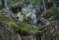
Title (German)
Brienz/Brinzauls GR, Wald unterhalb des Weilers Propissi Sot
Caption
Crevices, cracks and landslides in the forest, with fallen trees (Dürrholz), photograph 1989, partial view; keywords Documenta Natura: landslide.
Caption (German)
Spalten, Risse und Rutschungen im Wald, mit umgeworfenen Bäumen (Dürrholz), Aufnahme 1989, Teilansicht; Schlagworte Documenta Natura: Rutschung
Record Name
Dia_303-24850

Title (German)
Brienz/Brinzauls GR, Wald unterhalb des Weilers Propissi Sot
Caption
Crevices, cracks and landslides in the forest, with fallen trees (Dürrholz), rocky demolition edges, photograph 1989, partial view; keywords Documenta Natura: landslide.
Caption (German)
Spalten, Risse und Rutschungen im Wald, mit umgeworfenen Bäumen (Dürrholz), felsigen Abrisskanten, Aufnahme 1989, Teilansicht; Schlagworte Documenta Natura: Rutschung
Record Name
Dia_303-24853

Title (German)
Brienz/Brinzauls GR, Wald unterhalb des Weilers Propissi Sot
Caption
Crevices and landslides in the forest, with fallen trees (Dürrholz), photograph 1989, partial view; keywords Documenta Natura: landslide
Caption (German)
Spalten und Rutschungen im Wald, mit umgeworfenen Bäumen (Dürrholz), Aufnahme 1989, Teilansicht; Schlagworte Documenta Natura: Rutschung
Record Name
Dia_303-24856

Title (German)
Brienz/Brinzauls GR, Wald unterhalb des Weilers Propissi Sot
Caption
Crevices and cracks in the forest, with fallen trees (Dürrholz), photograph 1989, partial view; keywords Documenta Natura: landslide
Caption (German)
Spalten und Risse im Wald, mit umgeworfenen Bäumen (Dürrholz), Aufnahme 1989, Teilansicht; Schlagworte Documenta Natura: Rutschung
Record Name
Dia_303-24859

Title (German)
Brienz/Brinzauls GR, Wald unterhalb des Weilers Propissi Sot
Caption
Crevice with cracks and landslides in the forest, with fallen trees (Dürrholz), rocky demolition edges, photograph taken in 1989, detailed view; keywords Documenta Natura: landslide.
Caption (German)
Felsspalte mit Risse und Rutschungen im Wald, mit umgeworfenen Bäumen (Dürrholz), felsigen Abrisskanten, Aufnahme 1989, Detailansicht; Schlagworte Documenta Natura: Rutschung
Record Name
Dia_303-24862

Title (German)
Brienz/Brinzauls GR, Wald unterhalb des Weilers Propissi Sot
Caption
Crevice with cracks and landslides in the forest, with fallen trees (Dürrholz), photograph 1989, partial view; keywords Documenta Natura: landslide
Caption (German)
Felsspalte mit Risse und Rutschungen im Wald, mit umgeworfenen Bäumen (Dürrholz), Aufnahme 1989, Teilansicht; Schlagworte Documenta Natura: Rutschung
Record Name
Dia_303-24865

Title (German)
Brienz/Brinzauls GR, Wald unterhalb des Weilers Propissi Sot
Caption
Rocky edge of demolition with fallen trees (Dürrholz), photograph 1989, partial view; keywords Documenta Natura: landslide
Caption (German)
Felsige Abrisskante mit umgeworfenen Bäumen (Dürrholz), Aufnahme 1989, Teilansicht; Schlagworte Documenta Natura: Rutschung
Record Name
Dia_303-24868

Title (German)
Brienz/Brinzauls GR, Wald unterhalb des Weilers Propissi Sot
Caption
Crevices, cracks and landslides in the forest, with fallen trees (Dürrholz), photograph 1989, partial view; keywords Documenta Natura: landslide.
Caption (German)
Spalten, Risse und Rutschungen im Wald, mit umgeworfenen Bäumen (Dürrholz), Aufnahme 1989, Teilansicht; Schlagworte Documenta Natura: Rutschung
Record Name
Dia_303-24871
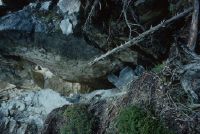
Title (German)
Brienz/Brinzauls GR, Wald unterhalb des Weilers Propissi Sot
Caption
Breakaway edge with fissures, cracks, photo 1995, detailed view; keywords Documenta Natura: landslide
Caption (German)
Abrisskante mit Spalten, Risse, Aufnahme 1995, Detailansicht; Schlagworte Documenta Natura: Rutschung
Record Name
Dia_303-24874

Title (German)
Brienz/Brinzauls GR, Wald unterhalb des Weilers Propissi Sot
Caption
Crevices and cracks in the forest, photo 1995, detail view; keywords Documenta Natura: landslide
Caption (German)
Spalten und Risse im Wald, Aufnahme 1995, Detailansicht; Schlagworte Documenta Natura: Rutschung
Record Name
Dia_303-24877

Title (German)
Brienz/Brinzauls GR, Wald unterhalb des Weilers Propissi Sot
Caption
Crevices and cracks in the forest, photo 1995, detail view; keywords Documenta Natura: landslide
Caption (German)
Spalten und Risse im Wald, Aufnahme 1995, Detailansicht; Schlagworte Documenta Natura: Rutschung
Record Name
Dia_303-24881

Title (German)
Brienz/Brinzauls GR, Wald unterhalb des Weilers Propissi Sot
Caption
Crevices and cracks and in the forest, with fallen trees (Dürrholz), photograph 1995, partial view; keywords Documenta Natura: landslide.
Caption (German)
Spalten und Risse und im Wald, mit umgeworfenen Bäumen (Dürrholz), Aufnahme 1995, Teilansicht; Schlagworte Documenta Natura: Rutschung
Record Name
Dia_303-24882

Title (German)
Brienz/Brinzauls GR, Wald unterhalb des Weilers Propissi Sot
Caption
Crevices, cracks and landslides in the forest, with fallen trees (Dürrholz), photograph 1995, partial view; keywords Documenta Natura: landslide.
Caption (German)
Spalten, Risse und Rutschungen im Wald, mit umgeworfenen Bäumen (Dürrholz), Aufnahme 1995, Teilansicht; Schlagworte Documenta Natura: Rutschung
Record Name
Dia_303-24887

Title (German)
Brienz/Brinzauls GR, Wald unterhalb des Weilers Propissi Sot
Caption
Crevices and cracks in rocky forest floor, with fallen trees (Dürrholz), photo 1995, partial view; keywords Documenta Natura: landslide.
Caption (German)
Spalten und Risse im felsigen Waldboden, mit umgeworfenen Bäumen (Dürrholz), Aufnahme 1995, Teilansicht; Schlagworte Documenta Natura: Rutschung
Record Name
Dia_303-24890

Title (German)
Brienz/Brinzauls GR, Wald unterhalb des Weilers Propissi Sot
Caption
Crevices, cracks and landslides in rocky forest floor, with fallen trees (Dürrholz), demolition edges, photo taken in 1995, partial view; keywords Documenta Natura: landslide.
Caption (German)
Spalten, Risse und Rutschungen im felsigen Waldboden, mit umgeworfenen Bäumen (Dürrholz), Abrisskanten, Aufnahme 1995, Teilansicht; Schlagworte Documenta Natura: Rutschung
Record Name
Dia_303-24893

Title (German)
Brienz/Brinzauls GR, Wald unterhalb des Weilers Propissi Sot
Caption
Crevices and cracks in rocky forest floor, photo 1995, detail view; keywords Documenta Natura: landslide.
Caption (German)
Spalten und Risse im felsigen Waldboden, Aufnahme 1995, Detailansicht; Schlagworte Documenta Natura: Rutschung
Record Name
Dia_303-24896

Title (German)
Brienz/Brinzauls GR, Wald unterhalb des Weilers Propissi Sot
Caption
Crevices and cracks in rocky forest floor, photo 1995, detail view; keywords Documenta Natura: landslide.
Caption (German)
Spalten und Risse im felsigen Waldboden, Aufnahme 1995, Detailansicht; Schlagworte Documenta Natura: Rutschung
Record Name
Dia_303-24899

Title (German)
Brienz/Brinzauls GR, Wald unterhalb des Weilers Propissi Sot
Caption
Crevices and cracks in rocky forest floor, photo 1995, detail view; keywords Documenta Natura: landslide.
Caption (German)
Spalten und Risse im felsigen Waldboden, Aufnahme 1995, Detailansicht; Schlagworte Documenta Natura: Rutschung
Record Name
Dia_303-24901

Title (German)
Brienz/Brinzauls GR, Wald unterhalb des Weilers Propissi Sot
Caption
Crevices and cracks in rocky forest floor, photo 1995, detail view; keywords Documenta Natura: landslide.
Caption (German)
Spalten und Risse im felsigen Waldboden, Aufnahme 1995, Detailansicht; Schlagworte Documenta Natura: Rutschung
Record Name
Dia_303-24904

Title (German)
Brienz/Brinzauls GR, Wald unterhalb des Weilers Propissi Sot
Caption
Crevices and cracks in rocky forest floor, photo 1995, detail view; keywords Documenta Natura: landslide.
Caption (German)
Spalten und Risse im felsigen Waldboden, Aufnahme 1995, Detailansicht; Schlagworte Documenta Natura: Rutschung
Record Name
Dia_303-24907

Title (German)
Brienz/Brinzauls GR, Wald unterhalb des Weilers Propissi Sot
Caption
Crevices, cracks in rocky part of the forest, with fallen trees (Dürrholz), photo 1995, partial view; keywords Documenta Natura: landslide.
Caption (German)
Spalten, Risse im felsigen Waldteil, mit umgeworfenen Bäumen (Dürrholz), Aufnahme 1995, Teilansicht; Schlagworte Documenta Natura: Rutschung
Record Name
Dia_303-24908

Title (German)
Brienz/Brinzauls GR, Wald unterhalb des Weilers Propissi Sot
Caption
Crevices, cracks and holes in rocky forest, with fallen trees (Dürrholz), photograph 1995, partial view; keywords Documenta Natura: landslide.
Caption (German)
Spalten, Risse und Löcher im felsigen Wald, mit umgeworfenen Bäumen (Dürrholz), Aufnahme 1995, Teilansicht; Schlagworte Documenta Natura: Rutschung
Record Name
Dia_303-24914

Title (German)
Brienz/Brinzauls GR, Wald unterhalb des Weilers Propissi Sot
Caption
Crevices, cracks and holes in rocky forest, with fallen trees (Dürrholz), photo 1995, partial view; keywords Documenta Natura: landslide.
Caption (German)
Spalten, Risse und Löcher im felsigen Wald, mit umgeworfenen Bäumen (Dürrholz), Aufnahme 1995, Teilansicht; Schlagworte Documenta Natura: Rutschung
Record Name
Dia_303-24918

Title (German)
Brienz/Brinzauls GR, Wald unterhalb des Weilers Propissi Sot
Caption
Crevices, cracks and holes in rocky forest, with fallen trees (Dürrholz), photograph 1995, partial view; keywords Documenta Natura: landslide.
Caption (German)
Spalten, Risse und Löcher im felsigen Wald, mit umgeworfenen Bäumen (Dürrholz), Aufnahme 1995, Teilansicht; Schlagworte Documenta Natura: Rutschung
Record Name
Dia_303-24921

Title (German)
Brienz/Brinzauls GR, Wald unterhalb des Weilers Propissi Sot
Caption
Crevices, cracks and holes in rocky forest, with fallen trees (Dürrholz), photo 1995, partial view; keywords Documenta Natura: landslide.
Caption (German)
Spalten, Risse und Löcher im felsigen Wald, mit umgeworfenen Bäumen (Dürrholz), Aufnahme 1995, Teilansicht; Schlagworte Documenta Natura: Rutschung
Record Name
Dia_303-24924

Title (German)
Brienz/Brinzauls GR, Wald unterhalb des Weilers Propissi Sot
Caption
Crevices, cracks and holes in rocky forest, with fallen trees (Dürrholz), photo 1995, partial view; keywords Documenta Natura: landslide.
Caption (German)
Spalten, Risse und Löcher im felsigen Wald, mit umgeworfenen Bäumen (Dürrholz), Aufnahme 1995, Teilansicht; Schlagworte Documenta Natura: Rutschung
Record Name
Dia_303-24929

Title (German)
Brienz/Brinzauls GR, Wald unterhalb des Weilers Propissi Sot
Caption
Wide crevice with cracks in the forest, with fallen trees (Dürrholz), photo 1995, partial view; keywords Documenta Natura: landslide.
Caption (German)
Breiter Felsspalt mit Rissen im Wald, mit umgeworfenen Bäumen (Dürrholz), Aufnahme 1995, Teilansicht; Schlagworte Documenta Natura: Rutschung
Record Name
Dia_303-24932

Title (German)
Brienz/Brinzauls GR, Wald unterhalb des Weilers Propissi Sot
Caption
Partly overgrown crevice in the forest, photo 1995, partial view; keywords Documenta Natura: landslide
Caption (German)
Teilweise überwachsener Felsspalt im Wald, Aufnahme 1995, Teilansicht; Schlagworte Documenta Natura: Rutschung
Record Name
Dia_303-24934

Title (German)
Brienz/Brinzauls GR, Wald unterhalb des Weilers Propissi Sot
Caption
Partially overgrown crevice in the forest, photo 1995, detailed view; keywords Documenta Natura: landslide
Caption (German)
Teilweise überwachsener Felsspalt im Wald, Aufnahme 1995, Detailansicht; Schlagworte Documenta Natura: Rutschung
Record Name
Dia_303-24937

Title (German)
Brienz/Brinzauls GR, ca. 100 m westlich Schautschen
Caption
Structure plenter-like high forest (group plentering) in the mountains, with natural regeneration (spruce, pine), at the edge of the forest, partial view across the slope; coordinates (LV03) of the camera location: 764975/172550; keywords Documenta Natura: landslide.
Caption (German)
Struktur plenterartiger Hochwald (Gruppenplenterung) im Gebirge, mit Naturverjüngung (Fichte, Föhre), am Waldrand, Teilansicht quer zum Hang; Koordinaten (LV03) des Kamerastandorts: 764975/172550; Schlagworte Documenta Natura: Rutschung
Record Name
Dia_303-24939

Title (German)
Brienz/Brinzauls GR, ca. 100 m westlich Schautschen
Caption
Structure plenter-like high forest (group plentering) in the mountains, with natural regeneration (spruce, pine), at the edge of the forest, partial view across the slope; coordinates (LV03) of the camera location: 764975/172550; keywords Documenta Natura: landslide.
Caption (German)
Struktur plenterartiger Hochwald (Gruppenplenterung) im Gebirge, mit Naturverjüngung (Fichte, Föhre), am Waldrand, Teilansicht quer zum Hang; Koordinaten (LV03) des Kamerastandorts: 764975/172550; Schlagworte Documenta Natura: Rutschung
Record Name
Dia_303-24942

Title (German)
Brienz/Brinzauls GR, Schutzwald unterhalb Igl Rutsch
Caption
Rocks caught in protection forest, tree tops torn off by rockfall, Dürrholz, partial view; keywords Documenta Natura: landslide.
Caption (German)
Aufgefangene Felsblöcke im Schutzwald, durch Steinschlag abgerissene Baumkronen, Dürrholz, Teilansicht; Schlagworte Documenta Natura: Rutschung
Record Name
Dia_303-24945

Title (German)
Brienz/Brinzauls GR, Schutzwald unterhalb Igl Rutsch
Caption
Rocks caught in protection forest; Tree crown torn off by rockfall, drought wood; Forest floor after rockfall with rock chips; Rockfall damage to trees; Emerging young growth in rockfall debris; Keywords Documenta Natura: landslide.
Caption (German)
Aufgefangene Felsblöcke im Schutzwald; Durch Steinschlag abgerissene Baumkrone, Dürrholz; Waldboden nach einem Steinaufschlag mit Felssplittern; Steinschlagschäden an Bäumen; Aufkommender Jungwuchs im Steinschlaggeröll; Schlagworte Documenta Natura: Rutschung
Record Name
Dia_303-24950

Title (German)
Brienz/Brinzauls GR, Schutzwald unterhalb Igl Rutsch
Caption
Captured boulders in protection forest, Dürrholz, partial view; keywords Documenta Natura: landslide.
Caption (German)
Aufgefangene Felsblöcke im Schutzwald, Dürrholz, Teilansicht; Schlagworte Documenta Natura: Rutschung
Record Name
Dia_303-24953

Title (German)
Brienz/Brinzauls GR, Schutzwald unterhalb Igl Rutsch
Caption
Captured boulders in protective forest, rockfall damage to trees (pines), partial view; keywords Documenta Natura: landslide.
Caption (German)
Aufgefangene Felsblöcke im Schutzwald, Steinschlagschäden an Bäumen (Föhren), Teilansicht; Schlagworte Documenta Natura: Rutschung
Record Name
Dia_303-24956

Title (German)
Brienz/Brinzauls GR, Schutzwald unterhalb Igl Rutsch
Caption
Captured boulders in protective forest, rockfall damage to trees (pines), partial view; keywords Documenta Natura: landslide.
Caption (German)
Aufgefangene Felsblöcke im Schutzwald, Steinschlagschäden an Bäumen (Föhren), Teilansicht; Schlagworte Documenta Natura: Rutschung
Record Name
Dia_303-24962

Title (German)
Brienz/Brinzauls GR, Schutzwald unterhalb Igl Rutsch
Caption
Rock caught by tree in protection forest, partial view; keywords Documenta Natura: landslide
Caption (German)
Durch Baum aufgefangener Felsblock im Schutzwald, Teilansicht; Schlagworte Documenta Natura: Rutschung
Record Name
Dia_303-24965

Title (German)
Brienz/Brinzauls GR, Schutzwald unterhalb Igl Rutsch
Caption
Tree bent and throttled by rockfall in protection forest, detail view; keywords Documenta Natura: landslide
Caption (German)
Durch Steinschlag geknickter und verdürrter Baum im Schutzwald, Detailansicht; Schlagworte Documenta Natura: Rutschung
Record Name
Dia_303-24969

Title (German)
Brienz/Brinzauls GR, Schutzwald unterhalb Igl Rutsch
Caption
Tree bent and throttled by rockfall in protection forest, detail view; keywords Documenta Natura: landslide
Caption (German)
Durch Steinschlag geknickter und verdürrter Baum im Schutzwald, Detailansicht; Schlagworte Documenta Natura: Rutschung
Record Name
Dia_303-24972

Title (German)
Brienz/Brinzauls GR, Schutzwald unterhalb Igl Rutsch
Caption
Captured boulder in protection forest, Dürrholz, partial view; keywords Documenta Natura: landslide.
Caption (German)
Aufgefangener Felsblock im Schutzwald, Dürrholz, Teilansicht; Schlagworte Documenta Natura: Rutschung
Record Name
Dia_303-24975

Title (German)
Brienz/Brinzauls GR, Schutzwald unterhalb Igl Rutsch
Caption
Forest floor littered with rock fragments and dry wood after a stone impact, detail view; keywords Documenta Natura: landslide
Caption (German)
Waldboden nach einem Steinaufschlag mit Felssplittern und Dürrholz übersät, Detailansicht; Schlagworte Documenta Natura: Rutschung
Record Name
Dia_303-24978

Title (German)
Brienz/Brinzauls GR, Schutzwald unterhalb Igl Rutsch
Caption
Forest floor littered with rock fragments and dry wood after a stone impact, detail view; keywords Documenta Natura: landslide
Caption (German)
Waldboden nach einem Steinaufschlag mit Felssplittern und Dürrholz übersät, Detailansicht; Schlagworte Documenta Natura: Rutschung
Record Name
Dia_303-24981

Title (German)
Brienz/Brinzauls GR, Schutzwald unterhalb Igl Rutsch
Caption
Trapped boulders in protective forest, drought wood, rockfall damage to trees, emerging young growth in rockfall debris, partial view upslope; keywords Documenta Natura: landslide.
Caption (German)
Aufgefangene Felsblöcke im Schutzwald, Dürrholz, Steinschlagschäden an Bäumen, aufkommender Jungwuchs im Steinschlaggeröll, Teilansicht hangaufwärts; Schlagworte Documenta Natura: Rutschung
Record Name
Dia_303-24987

Title (German)
Brienz/Brinzauls GR, Schutzwald unterhalb Igl Rutsch
Caption
Emerging young growth in rockfall scree, detailed view; keywords Documenta Natura: landslide
Caption (German)
Aufkommender Jungwuchs im Steinschlaggeröll, Detailansicht; Schlagworte Documenta Natura: Rutschung
Record Name
Dia_303-24990

Title (German)
Brienz/Brinzauls GR, Schutzwald unterhalb Igl Rutsch
Caption
Emerging young growth in rockfall scree, detailed view; keywords Documenta Natura: landslide
Caption (German)
Aufkommender Jungwuchs im Steinschlaggeröll, Detailansicht; Schlagworte Documenta Natura: Rutschung
Record Name
Dia_303-24993

Title (German)
Brienz/Brinzauls GR, Waldweide nördlich von Brienz
Caption
Browsing damage to young spruce trees by wild animals and domestic animals (sheep, cows), in grazed tree population (larches), general view; keywords Documenta Natura: landslide.
Caption (German)
Verbissschäden an jungen Fichten durch Wildtiere und Haustiere (Schafe, Kühe), in beweidetem Baumbestand (Lärchen), Gesamtansicht; Schlagworte Documenta Natura: Rutschung
Record Name
Dia_303-24996

Title (German)
Brienz/Brinzauls GR, Waldweide nördlich von Brienz
Caption
Browsing damage to young spruce trees by wild animals and domestic animals (sheep, cows), in grazed tree population (larches), partial view; keywords Documenta Natura: landslide.
Caption (German)
Verbissschäden an jungen Fichten durch Wildtiere und Haustiere (Schafe, Kühe), in beweidetem Baumbestand (Lärchen), Teilansicht; Schlagworte Documenta Natura: Rutschung
Record Name
Dia_303-24999

Title (German)
Brienz/Brinzauls GR, Waldweide nördlich von Brienz
Caption
Browsing damage to young spruce in grazed tree stand, partial view; keywords Documenta Natura: landslide.
Caption (German)
Verbissschäden an junger Fichte in beweidetem Baumbestand, Teilansicht; Schlagworte Documenta Natura: Rutschung
Record Name
Dia_303-25001

Title (German)
Brienz/Brinzauls GR, Waldweide nördlich von Brienz
Caption
Browsing damage to young spruce in grazed tree stand by wild animals and domestic animals (sheep, cows), partial view; keywords Documenta Natura: landslide.
Caption (German)
Verbissschäden an jungen Fichten in beweidetem Baumbestand durch Wildtiere und Haustiere (Schafe, Kühe), Teilansicht; Schlagworte Documenta Natura: Rutschung
Record Name
Dia_303-25005

Title (German)
Brienz/Brinzauls GR, Waldweide nördlich von Brienz
Caption
Browsing damage to young spruce in grazed tree stand by wild animals and domestic animals (sheep, cows), partial view; keywords Documenta Natura: landslide.
Caption (German)
Verbissschäden an jungen Fichten in beweidetem Baumbestand durch Wildtiere und Haustiere (Schafe, Kühe), Teilansicht; Schlagworte Documenta Natura: Rutschung
Record Name
Dia_303-25008

Title (German)
Brienz/Brinzauls GR, Waldweide nördlich von Brienz
Caption
Cows and sheep grazing on forest pasture, with larch stand; keywords Documenta Natura: landslide
Caption (German)
Kühe und Schafe beim Weiden auf Waldweide, mit Lärchenbestand; Schlagworte Documenta Natura: Rutschung
Record Name
Dia_303-25012

Title (German)
Brienz/Brinzauls GR, Waldweide nördlich von Brienz
Caption
Cows and sheep grazing on forest pasture, with larch stand; keywords Documenta Natura: landslide
Caption (German)
Kühe und Schafe beim Weiden auf Waldweide, mit Lärchenbestand; Schlagworte Documenta Natura: Rutschung
Record Name
Dia_303-25015

Title (German)
Brienz/Brinzauls GR, Waldweide nördlich von Brienz
Caption
Cows and sheep grazing on forest pasture, with larch stand and young growth (partially browsed); keywords Documenta Natura: landslide.
Caption (German)
Kühe und Schafe beim Weiden auf Waldweide, mit Lärchenbestand und Jungwuchs (teilweise verbissen); Schlagworte Documenta Natura: Rutschung
Record Name
Dia_303-25017

Title (German)
Brienz/Brinzauls GR, Wald nordöstlich von Brienz, unterhalb des Weges Brienz-Propissi
Caption
Landslides in forest with pushed away trees, scrawny trunks on the ground, partial view; keywords Documenta Natura: landslide
Caption (German)
Rutschungen im Wald mit abgedrückten Bäumen, dürre Stämme am Boden, Teilansicht; Schlagworte Documenta Natura: Rutschung
Record Name
Dia_303-25031

Title (German)
Brienz/Brinzauls GR, Wald nordöstlich von Brienz, unterhalb des Weges Brienz-Propissi
Caption
Landslides in forest with depressed and sloping trees, partial view; keywords Documenta Natura: landslide
Caption (German)
Rutschungen im Wald mit abgedrückten und schrägen Bäumen, Teilansicht; Schlagworte Documenta Natura: Rutschung
Record Name
Dia_303-25035

Title (German)
Brienz/Brinzauls GR, Wald nördlich von Brienz, links und rechts des Fussweges
Caption
Structure of the protective forest with rocky subsoil, boulders overgrown with moss, partial view; keywords Documenta Natura: landslide.
Caption (German)
Struktur des Schutzwaldes mit felsigem Untergrund, mit Moos überwachsenen Steinbrocken, Teilansicht; Schlagworte Documenta Natura: Rutschung
Record Name
Dia_303-25039

Title (German)
Brienz/Brinzauls GR, Wald nördlich von Brienz, links und rechts des Fussweges
Caption
Rocky, barren ground and boulders overgrown with moss, detail view; keywords Documenta Natura: landslide.
Caption (German)
Felsiger, karger Untergrund und mit Moos überwachsenen Steinbrocken, Detailansicht; Schlagworte Documenta Natura: Rutschung
Record Name
Dia_303-25043

Title (German)
Brienz/Brinzauls GR, Wald nördlich von Brienz, links und rechts des Fussweges
Caption
Rocky, barren ground and boulders overgrown with moss, detail view; keywords Documenta Natura: landslide.
Caption (German)
Felsiger, karger Untergrund und mit Moos überwachsenen Steinbrocken, Detailansicht; Schlagworte Documenta Natura: Rutschung
Record Name
Dia_303-25046
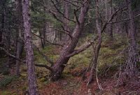
Title (German)
Brienz/Brinzauls GR, Wald nördlich von Brienz, links und rechts des Fussweges
Caption
Structure of protection forest, decapitated tree crown (deadwood), partial view; keywords Documenta Natura: landslide.
Caption (German)
Struktur des Schutzwaldes, geköpfte Baumkrone (Totholz), Teilansicht; Schlagworte Documenta Natura: Rutschung
Record Name
Dia_303-25050

Title (German)
Brienz/Brinzauls GR, Wald nördlich von Brienz, links und rechts des Fussweges
Caption
Structure of protection forest, decapitated tree crown (deadwood), partial view; keywords Documenta Natura: landslide.
Caption (German)
Struktur des Schutzwaldes, geköpfte Baumkrone (Totholz), Teilansicht; Schlagworte Documenta Natura: Rutschung
Record Name
Dia_303-25054

Title (German)
Brienz/Brinzauls GR, Wald nördlich von Brienz, links und rechts des Fussweges
Caption
Structure of protection forest with hiking trail, partial view; keywords Documenta Natura: landslide.
Caption (German)
Struktur des Schutzwaldes mit Wanderweg, Teilansicht; Schlagworte Documenta Natura: Rutschung
Record Name
Dia_303-25058

Title (German)
Brienz/Brinzauls GR, Wald nördlich von Brienz, links und rechts des Fussweges
Caption
Structure of protection forest with young growth on scree slope, partial view; keywords Documenta Natura: landslide
Caption (German)
Struktur des Schutzwaldes mit Jungwuchs auf Geröllhalde, Teilansicht; Schlagworte Documenta Natura: Rutschung
Record Name
Dia_303-25062

Title (German)
Brienz/Brinzauls GR, Wald nördlich von Brienz, links und rechts des Fussweges
Caption
Rocky, barren ground and boulders overgrown with moss, detail view; keywords Documenta Natura: landslide.
Caption (German)
Felsiger, karger Untergrund und mit Moos überwachsenen Steinbrocken, Detailansicht; Schlagworte Documenta Natura: Rutschung
Record Name
Dia_303-25066

Title (German)
Brienz/Brinzauls GR, Wald westlich des Weilers Propissi Saura
Caption
Structure of pine forest, pines pushed by snow pressure, with fog in the background, partial view; keywords Documenta Natura: landslide
Caption (German)
Struktur des Föhrenwaldes, durch Schneedruck gestossene Föhren, mit Nebel im Hintergrund, Teilansicht; Schlagworte Documenta Natura: Rutschung
Record Name
Dia_303-25072

Title (German)
Brienz/Brinzauls GR, Wald westlich des Weilers Propissi Saura
Caption
Structure of pine forest, pines pushed by snow pressure, with fog in the background, partial view; keywords Documenta Natura: landslide
Caption (German)
Struktur des Föhrenwaldes, durch Schneedruck gestossene Föhren, mit Nebel im Hintergrund, Teilansicht; Schlagworte Documenta Natura: Rutschung
Record Name
Dia_303-25074

Title (German)
Brienz/Brinzauls GR, Wald westlich des Weilers Propissi Saura
Caption
Structure of pine forest, pines pushed by snow pressure, with fog in the background, partial view; keywords Documenta Natura: landslide
Caption (German)
Struktur des Föhrenwaldes, durch Schneedruck gestossene Föhren, mit Nebel im Hintergrund, Teilansicht; Schlagworte Documenta Natura: Rutschung
Record Name
Dia_303-25077

Title (German)
Brienz/Brinzauls GR, Wald westlich des Weilers Propissi Saura
Caption
Structure of pine forest, pines pushed by snow pressure, with fog in the background, partial view; keywords Documenta Natura: landslide
Caption (German)
Struktur des Föhrenwaldes, durch Schneedruck gestossene Föhren, mit Nebel im Hintergrund, Teilansicht; Schlagworte Documenta Natura: Rutschung
Record Name
Dia_303-25080

Title (German)
Brienz/Brinzauls GR, Wald westlich des Weilers Propissi Saura
Caption
Structure of pine forest, natural regeneration of pine and spruce, partial view; keywords Documenta Natura: landslide.
Caption (German)
Struktur des Föhrenwaldes, Naturverjüngung von Föhre und Fichte, Teilansicht; Schlagworte Documenta Natura: Rutschung
Record Name
Dia_303-25083

Title (German)
Brienz/Brinzauls GR, Wald westlich des Weilers Propissi Saura
Caption
Structure of pine forest, spruce with new shoots and pine in bloom, partial view; Keywords Documenta Natura: landslide.
Caption (German)
Struktur des Föhrenwaldes, Fichte mit neuem Austrieb und Föhre in Blüte, Teilansicht; Schlagworte Documenta Natura: Rutschung
Record Name
Dia_303-25086