 E-PICS - ETHBIB.Bildarchiv


The images presented on this page are part of E-Pics, a service provided by the ETH-Bibliothek of ETH Zurich. You find here static medium resolution images published under the creative commons
CC-BY-SA license or with the Public Domain Mark. This means that you are free to share, copy and redistribute the material in any medium or format; that you are free to remix, transform, and build upon the material for any purpose, even commercially, under the following conditions: You must give appropriate credit, provide a link to the license, and indicate if changes were made.
- More information about E-Pics is available at https://www.e-pics.ethz.ch
- This catalog can also be accessed at https://ba.e-pics.ethz.ch/ . There you can download the image in a higher resolution.

Title (German)
Wells, Kathedrale, Westfassade
Caption
Title tab: Wells; cathedral; west facade
Caption (German)
Titel Reiter: Wells; Kathedrale; Westfassade
Record Name
Dia_287-30335

Title (German)
Wells, Kathedrale, Westfassade
Caption
Title tab: Wells; cathedral; west facade
Caption (German)
Titel Reiter: Wells; Kathedrale; Westfassade
Record Name
Dia_287-30336

Title (German)
Wells, Kathedrale, Portale, Westfassade
Caption
Title tab: Wells; cathedral; west facade
Caption (German)
Titel Reiter: Wells; Kathedrale; Westfassade
Record Name
Dia_287-30337

Title (German)
Wells, Kathedrale, Westportal, Westfassade
Caption
Title tab: Wells; cathedral; west facade
Caption (German)
Titel Reiter: Wells; Kathedrale; Westfassade
Record Name
Dia_287-30338

Title (German)
Wells, Kathedrale, Langhaus, St. Andreas, Langhaus nach Osten, innen
Caption
Title tab: Wells; cathedral; interior; nave
Caption (German)
Titel Reiter: Wells; Kathedrale; innen; Langhaus
Record Name
Dia_287-30339

Title (German)
Wells, Kathedrale, Langhaus, Mittelschiff nach Osten, innen
Caption
Title tab: Wells; cathedral; interior; nave
Caption (German)
Titel Reiter: Wells; Kathedrale; innen; Langhaus
Record Name
Dia_287-30340

Title (German)
Wells, Kathedrale, Langhaus, Mittelschiff nach Osten, innen
Caption
Title tab: Wells; cathedral; interior; nave
Caption (German)
Titel Reiter: Wells; Kathedrale; innen; Langhaus
Record Name
Dia_287-30341

Title (German)
Wells, Kathedrale, Langhaus, Mittelschiff nach Osten, innen
Caption
Title tab: Wells; cathedral; interior; nave
Caption (German)
Titel Reiter: Wells; Kathedrale; innen; Langhaus
Record Name
Dia_287-30342

Title (German)
Wells, Kathedrale, Langhaus, Mittelschiff nach Osten, innen
Caption
Title tab: Wells; cathedral; interior; nave
Caption (German)
Titel Reiter: Wells; Kathedrale; innen; Langhaus
Record Name
Dia_287-30343

Title (German)
Wells, Kathedrale, Langhaus, Mittelschiff nach Osten, innen
Caption
Title tab: Wells; cathedral; interior; nave
Caption (German)
Titel Reiter: Wells; Kathedrale; innen; Langhaus
Record Name
Dia_287-30344

Title (German)
Wells, Kathedrale, Langhaus, Langhaus (1191ff), Triforium, innen
Caption
Title tab: Wells; cathedral; interior; nave
Caption (German)
Titel Reiter: Wells; Kathedrale; innen; Langhaus
Record Name
Dia_287-30345

Title (German)
Wells, Kathedrale, Langhaus, Vierungsbogen, innen
Caption
Title tab: Wells; cathedral; interior; nave
Caption (German)
Titel Reiter: Wells; Kathedrale; innen; Langhaus
Record Name
Dia_287-30346

Title (German)
Wells, Kathedrale, Langhaus, Vierung von Südosten, innen
Caption
Title tab: Wells; cathedral; interior; nave
Caption (German)
Titel Reiter: Wells; Kathedrale; innen; Langhaus
Record Name
Dia_287-30347

Title (German)
Wells, Kathedrale, Langhaus, Vierungsbogen von Westen, innen
Caption
Title tab: Wells; cathedral; interior; nave
Caption (German)
Titel Reiter: Wells; Kathedrale; innen; Langhaus
Record Name
Dia_287-30348

Title (German)
Wells, Kathedrale, Querhaus, Querhaus nach Norden, innen
Caption
Title tab: Wells; cathedral; inside; transept
Caption (German)
Titel Reiter: Wells; Kathedrale; innen; Querhaus
Record Name
Dia_287-30349

Title (German)
Wells, Kathedrale, Querhaus, Querhaus von Südosten, innen
Caption
Title tab: Wells; cathedral; inside; transept
Caption (German)
Titel Reiter: Wells; Kathedrale; innen; Querhaus
Record Name
Dia_287-30350

Title (German)
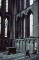
Wells, Kathedrale, Chor, Chor und Retrochor, innen
Caption
Title rider: Wells; cathedral; inside; choir
Caption (German)
Titel Reiter: Wells; Kathedrale; innen; Chor
Record Name
Dia_287-30351

Title (German)
Wells, Kathedrale, Chor, Chor und Retrochor, innen
Caption
Title rider: Wells; cathedral; inside; choir
Caption (German)
Titel Reiter: Wells; Kathedrale; innen; Chor
Record Name
Dia_287-30352

Title (German)
Wells, Kathedrale, Chor, Retrochor, innen
Caption
Title rider: Wells; cathedral; inside; choir
Caption (German)
Titel Reiter: Wells; Kathedrale; innen; Chor
Record Name
Dia_287-30353

Title (German)
Wells, Kathedrale, Chor, innen
Caption
Title rider: Wells; cathedral; inside; choir
Caption (German)
Titel Reiter: Wells; Kathedrale; innen; Chor
Record Name
Dia_287-30354

Title (German)
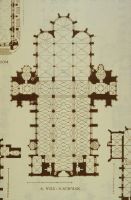
Wells, Kathedrale, Kapitelsaal
Caption
Title tab: Wells; Cathedral; Chapter House
Caption (German)
Titel Reiter: Wells; Kathedrale; Kapitelsaal
Record Name
Dia_287-30355

Title (German)
Wells, Kathedrale, Kapitelsaal
Caption
Title tab: Wells; Cathedral; Chapter House
Caption (German)
Titel Reiter: Wells; Kathedrale; Kapitelsaal
Record Name
Dia_287-30356

Title (German)
Wells, Kathedrale, Kapitelsaal
Caption
Title tab: Wells; Cathedral; Chapter House
Caption (German)
Titel Reiter: Wells; Kathedrale; Kapitelsaal
Record Name
Dia_287-30357

Title (German)
Wells, Kathedrale, Kapitelhaus, Kapitelsaal
Caption
Keyword photographer: floor plan. Title rider: Wells; cathedral; chapter house
Caption (German)
Schlagwort Bestandsbildner: Grundriss. Titel Reiter: Wells; Kathedrale; Kapitelsaal
Record Name
Dia_287-30358

Title (German)
Werden am Rhein, Saec. 9. 11. 13
Caption
Keyword photographer: floor plan. Title rider: Werden on the Rhine
Caption (German)
Schlagwort Bestandsbildner: Grundriss. Titel Reiter: Werden am Rhein
Record Name
Dia_287-30359

Title (German)
Werden am Rhein, Werden am Rhein
Caption
Keyword photographer: floor plan. Title rider: Werden on the Rhine
Caption (German)
Schlagwort Bestandsbildner: Grundriss. Titel Reiter: Werden am Rhein
Record Name
Dia_287-30360

Title (German)
Werden am Rhein, Benediktinerkirche
Caption
Keyword photographer: floor plan. Title rider: Werden on the Rhine
Caption (German)
Schlagwort Bestandsbildner: Grundriss. Titel Reiter: Werden am Rhein
Record Name
Dia_287-30361

Title (German)
Werden am Rhein, Krypta
Caption
Keyword photographer: floor plan. Title rider: Werden on the Rhine
Caption (German)
Schlagwort Bestandsbildner: Grundriss. Titel Reiter: Werden am Rhein
Record Name
Dia_287-30362

Title (German)
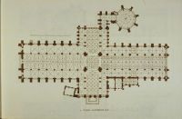
Werden am Rhein, Benediktinerkirche, saec. 9, links, saec. 13, rechts
Caption
Keyword photographer: floor plan. Title rider: Werden on the Rhine
Caption (German)
Schlagwort Bestandsbildner: Grundriss. Titel Reiter: Werden am Rhein
Record Name
Dia_287-30363

Title (German)
Werden am Rhein, St. Luzius
Caption
Title rider: Werden on the Rhine
Caption (German)
Titel Reiter: Werden am Rhein
Record Name
Dia_287-30364

Title (German)
Wesel, Nach Westen, 1960
Caption
Keyword photographer: floor plan. Title rider: Wesel
Caption (German)
Schlagwort Bestandsbildner: Grundriss. Titel Reiter: Wesel
Record Name
Dia_287-30365

Title (German)
Wetter
Caption
Keyword photographer: floor plan. Title tab: Weather
Caption (German)
Schlagwort Bestandsbildner: Grundriss. Titel Reiter: Wetter
Record Name
Dia_287-30366

Title (German)
Wetter
Caption
Keyword photographer: floor plan. Title tab: Weather
Caption (German)
Schlagwort Bestandsbildner: Grundriss. Titel Reiter: Wetter
Record Name
Dia_287-30367

Title (German)
Wetter
Caption
Keyword photographer: floor plan. Title tab: Weather
Caption (German)
Schlagwort Bestandsbildner: Grundriss. Titel Reiter: Wetter
Record Name
Dia_287-30368

Title (German)
Wettingen, Wettingen
Caption
Photographer keyword: floor plan. Title rider: Wettingen
Caption (German)
Schlagwort Bestandsbildner: Grundriss. Titel Reiter: Wettingen
Record Name
Dia_287-30369

Title (German)
Wetzlar
Caption
Keyword photographer: floor plan. Title rider: Wetzlar
Caption (German)
Schlagwort Bestandsbildner: Grundriss. Titel Reiter: Wetzlar
Record Name
Dia_287-30370

Title (German)
Wetzlar
Caption
Keyword photographer: floor plan. Title rider: Wetzlar
Caption (German)
Schlagwort Bestandsbildner: Grundriss. Titel Reiter: Wetzlar
Record Name
Dia_287-30371

Title (German)
Wetzlar
Caption
Keyword photographer: floor plan. Title rider: Wetzlar
Caption (German)
Schlagwort Bestandsbildner: Grundriss. Titel Reiter: Wetzlar
Record Name
Dia_287-30372

Title (German)
Whitby, Seitenschiff
Caption
Keyword photographer: floor plan. Title tab: Whitby
Caption (German)
Schlagwort Bestandsbildner: Grundriss. Titel Reiter: Whitby
Record Name
Dia_287-30373

Title (German)
Whitby, Whitby
Caption
Keyword photographer: floor plan. Title tab: Whitby
Caption (German)
Schlagwort Bestandsbildner: Grundriss. Titel Reiter: Whitby
Record Name
Dia_287-30374
Title (German)
Wien, St. Stephan
Caption
Keyword photographer: floor plan. Title rider: Vienna; St. Stephen
Caption (German)
Schlagwort Bestandsbildner: Grundriss. Titel Reiter: Wien; St. Stephan
Record Name
Dia_287-30375

Title (German)
Wien, St. Stephan
Caption
Keyword photographer: floor plan. Title rider: Vienna; St. Stephen
Caption (German)
Schlagwort Bestandsbildner: Grundriss. Titel Reiter: Wien; St. Stephan
Record Name
Dia_287-30376

Title (German)
Wien, St. Stephan
Caption
Keyword photographer: floor plan. Title rider: Vienna; St. Stephen
Caption (German)
Schlagwort Bestandsbildner: Grundriss. Titel Reiter: Wien; St. Stephan
Record Name
Dia_287-30377

Title (German)
Wien, St. Stephan, Stephansdom von Südwesten
Caption
Title rider: Vienna; St. Stephen
Caption (German)
Titel Reiter: Wien; St. Stephan
Record Name
Dia_287-30378

Title (German)
Wien, St. Stephan, Südseite
Caption
Title rider: Vienna; St. Stephen
Caption (German)
Titel Reiter: Wien; St. Stephan
Record Name
Dia_287-30379

Title (German)
Wien, St. Stephan, Stephansdom
Caption
Title rider: Vienna; St. Stephen
Caption (German)
Titel Reiter: Wien; St. Stephan
Record Name
Dia_287-30380

Title (German)
Wien, Neustadt, Wiener Neustadt
Caption
Keyword photographer: floor plan. Title rider: Vienna; Neustadt
Caption (German)
Schlagwort Bestandsbildner: Grundriss. Titel Reiter: Wien; Neustadt
Record Name
Dia_287-30381
Title (German)
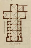
Wildeshausen
Caption
Keyword photographer: floor plan. Title rider: Wildeshausen
Caption (German)
Schlagwort Bestandsbildner: Grundriss. Titel Reiter: Wildeshausen
Record Name
Dia_287-30382

Title (German)
Wildeshausen
Caption
Keyword photographer: floor plan. Title rider: Wildeshausen
Caption (German)
Schlagwort Bestandsbildner: Grundriss. Titel Reiter: Wildeshausen
Record Name
Dia_287-30383

Title (German)
Wildeshausen
Caption
Keyword photographer: floor plan. Title rider: Wildeshausen
Caption (German)
Schlagwort Bestandsbildner: Grundriss. Titel Reiter: Wildeshausen
Record Name
Dia_287-30384

Title (German)
Wimpfen im Thal, Wimpfen im Thal
Caption
Keyword photographer: Floor plan. Title rider: Wimpfen in the valley
Caption (German)
Schlagwort Bestandsbildner: Grundriss. Titel Reiter: Wimpfen im Thal
Record Name
Dia_287-30385

Title (German)
Wimpfen im Thal, Fassade des Querschiffs
Caption
Keyword photographer: Floor plan. Title rider: Wimpfen in the valley
Caption (German)
Schlagwort Bestandsbildner: Grundriss. Titel Reiter: Wimpfen im Thal
Record Name
Dia_287-30386

Title (German)
Wimpfen im Thal
Caption
Keyword photographer: floor plan. Title rider: Wimpfen in the valley
Caption (German)
Schlagwort Bestandsbildner: Grundriss. Titel Reiter: Wimpfen im Thal
Record Name
Dia_287-30387

Title (German)
Winchester, Beg. A. 1079
Caption
Keywords photographer: floor plan, cathedral. Title rider: Winchester
Caption (German)
Schlagworte Bestandsbildner: Grundriss, Kathedrale. Titel Reiter: Winchester
Record Name
Dia_287-30388

Title (German)
Winchester, Chor
Caption
Keywords photographer: floor plan, cathedral. Title rider: Winchester
Caption (German)
Schlagworte Bestandsbildner: Grundriss, Kathedrale. Titel Reiter: Winchester
Record Name
Dia_287-30389

Title (German)
Winchester, System Langhaus
Caption
Keywords photographer: floor plan, cathedral. Title rider: Winchester
Caption (German)
Schlagworte Bestandsbildner: Grundriss, Kathedrale. Titel Reiter: Winchester
Record Name
Dia_287-30390

Title (German)
Winchester, E. saec. 11
Caption
Keywords photographer: floor plan, cathedral. Title rider: Winchester
Caption (German)
Schlagworte Bestandsbildner: Grundriss, Kathedrale. Titel Reiter: Winchester
Record Name
Dia_287-30391

Title (German)
Winchester, Langhaus
Caption
Keywords photographer: floor plan, cathedral. Title rider: Winchester
Caption (German)
Schlagworte Bestandsbildner: Grundriss, Kathedrale. Titel Reiter: Winchester
Record Name
Dia_287-30392

Title (German)
Winchester, Langhaus
Caption
Keywords photographer: floor plan, cathedral. Title rider: Winchester
Caption (German)
Schlagworte Bestandsbildner: Grundriss, Kathedrale. Titel Reiter: Winchester
Record Name
Dia_287-30393

Title (German)
Winchester, Heilige Dreifalitgkeit, Langhaus nach Westen
Caption
Keyword photographer: Cathedral. Title rider: Winchester
Caption (German)
Schlagwort Bestandsbildner: Kathedrale. Titel Reiter: Winchester
Record Name
Dia_287-30394

Title (German)
Winchester, Heilige Dreifaltigkeit, Chorgewölbe gegen Osten
Caption
Keyword photographer: Cathedral. Title rider: Winchester
Caption (German)
Schlagwort Bestandsbildner: Kathedrale. Titel Reiter: Winchester
Record Name
Dia_287-30395

Title (German)
Windsor, S. Georges Chapel
Caption
Keyword photographer: Floor plan. Title rider: Windsor
Caption (German)
Schlagwort Bestandsbildner: Grundriss. Titel Reiter: Windsor
Record Name
Dia_287-30396

Title (German)
Winschoten, Winschoten
Caption
Keyword photographer: floor plan. Title rider: Winschoten
Caption (German)
Schlagwort Bestandsbildner: Grundriss. Titel Reiter: Winschoten
Record Name
Dia_287-30397

Title (German)
Wismar, St. Georg, Ruine
Caption
Title rider: Wismar; St. George
Caption (German)
Titel Reiter: Wismar; St. Georg
Record Name
Dia_287-30398

Title (German)
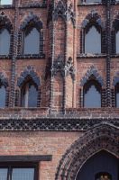
Wismar, St. Georg, Giebel
Caption
Title rider: Wismar; St. George
Caption (German)
Titel Reiter: Wismar; St. Georg
Record Name
Dia_287-30399

Title (German)
Wismar, St. Georg, Ruine
Caption
Title rider: Wismar; St. George
Caption (German)
Titel Reiter: Wismar; St. Georg
Record Name
Dia_287-30400

Title (German)
Wismar, St. Georg, Ruine
Caption
Title rider: Wismar; St. George
Caption (German)
Titel Reiter: Wismar; St. Georg
Record Name
Dia_287-30401

Title (German)
Wismar, St. Georg, Ruine
Caption
Title rider: Wismar; St. George
Caption (German)
Titel Reiter: Wismar; St. Georg
Record Name
Dia_287-30402

Title (German)
Wismar, St. Georg, Ruine
Caption
Title rider: Wismar; St. George
Caption (German)
Titel Reiter: Wismar; St. Georg
Record Name
Dia_287-30403

Title (German)
Wismar, St. Georg, Ruine
Caption
Title rider: Wismar; St. George
Caption (German)
Titel Reiter: Wismar; St. Georg
Record Name
Dia_287-30404

Title (German)
Wismar, St. Nicolai, S. Nikolaikirche
Caption
Keyword photographer: floor plan. Title rider: Wismar; St. Nicolai
Caption (German)
Schlagwort Bestandsbildner: Grundriss. Titel Reiter: Wismar; St. Nicolai
Record Name
Dia_287-30405

Title (German)
Wismar, St. Nicolai, Von Südwesten
Caption
Title rider: Wismar; St. Nicolai
Caption (German)
Titel Reiter: Wismar; St. Nicolai
Record Name
Dia_287-30406

Title (German)
Wismar, St. Nicolai, Von Südwesten
Caption
Title rider: Wismar; St. Nicolai
Caption (German)
Titel Reiter: Wismar; St. Nicolai
Record Name
Dia_287-30407

Title (German)
Wismar, St. Nicolai, Südgiebel
Caption
Title rider: Wismar; St. Nicolai
Caption (German)
Titel Reiter: Wismar; St. Nicolai
Record Name
Dia_287-30408

Title (German)
Wismar, St. Nicolai, Turm
Caption
Title rider: Wismar; St. Nicolai
Caption (German)
Titel Reiter: Wismar; St. Nicolai
Record Name
Dia_287-30409

Title (German)
Wismar, St. Nicolai, Südgiebel
Caption
Title rider: Wismar; St. Nicolai
Caption (German)
Titel Reiter: Wismar; St. Nicolai
Record Name
Dia_287-30410

Title (German)
Wismar, St. Nicolai, Südgiebel
Caption
Title rider: Wismar; St. Nicolai
Caption (German)
Titel Reiter: Wismar; St. Nicolai
Record Name
Dia_287-30411

Title (German)
Wismar, St. Nicolai, Von Südwesten
Caption
Title rider: Wismar; St. Nicolai
Caption (German)
Titel Reiter: Wismar; St. Nicolai
Record Name
Dia_287-30412

Title (German)
Wismar, St. Nicolai, Südseite
Caption
Title rider: Wismar; St. Nicolai
Caption (German)
Titel Reiter: Wismar; St. Nicolai
Record Name
Dia_287-30413

Title (German)
Wismar, Notkirche, Notkirche von Bartning
Caption
Title rider: Wismar; emergency church
Caption (German)
Titel Reiter: Wismar; Notkirche
Record Name
Dia_287-30414

Title (German)
Wismar, Marktplatz, Alter Schwede
Caption
Title rider: Wismar; Varia
Caption (German)
Titel Reiter: Wismar; Varia
Record Name
Dia_287-30415

Title (German)
Wismar, Marktplatz, Alter Schwede
Caption
Title rider: Wismar; Varia
Caption (German)
Titel Reiter: Wismar; Varia
Record Name
Dia_287-30416
Title (German)
Wismar, Marktplatz, Alter Schwede
Caption
Title rider: Wismar; Varia
Caption (German)
Titel Reiter: Wismar; Varia
Record Name
Dia_287-30417

Title (German)
Wismar, Marktplatz, Alter Schwede
Caption
Title rider: Wismar; Varia
Caption (German)
Titel Reiter: Wismar; Varia
Record Name
Dia_287-30418

Title (German)
Worcester, Worcester
Caption
Keyword photographer: floor plan. Title tab: Worcester
Caption (German)
Schlagwort Bestandsbildner: Grundriss. Titel Reiter: Worcester
Record Name
Dia_287-30419

Title (German)
Worcester, Chor und Querhaus
Caption
Keyword photographer: Cathedral. Title rider: Worcester
Caption (German)
Schlagwort Bestandsbildner: Kathedrale. Titel Reiter: Worcester
Record Name
Dia_287-30420

Title (German)
Worcester, Chor
Caption
Keyword photographer: Cathedral. Title rider: Worcester
Caption (German)
Schlagwort Bestandsbildner: Kathedrale. Titel Reiter: Worcester
Record Name
Dia_287-30421

Title (German)
Worcester, Chor von aussen
Caption
Keyword photographer: Cathedral. Title rider: Worcester
Caption (German)
Schlagwort Bestandsbildner: Kathedrale. Titel Reiter: Worcester
Record Name
Dia_287-30422

Title (German)
Worcester, Westfassade
Caption
Keyword photographer: Cathedral. Title rider: Worcester
Caption (German)
Schlagwort Bestandsbildner: Kathedrale. Titel Reiter: Worcester
Record Name
Dia_287-30423

Title (German)
Worcester, Westfassade
Caption
Keyword photographer: Cathedral. Title rider: Worcester
Caption (German)
Schlagwort Bestandsbildner: Kathedrale. Titel Reiter: Worcester
Record Name
Dia_287-30424

Title (German)
Worcester, Chor, innen
Caption
Keyword photographer: Cathedral. Title rider: Worcester; inside
Caption (German)
Schlagwort Bestandsbildner: Kathedrale. Titel Reiter: Worcester; innen
Record Name
Dia_287-30425

Title (German)
Worcester, Chor von Südwesten, innen
Caption
Keyword photographer: Cathedral. Title rider: Worcester; inside
Caption (German)
Schlagwort Bestandsbildner: Kathedrale. Titel Reiter: Worcester; innen
Record Name
Dia_287-30426

Title (German)
Worcester, Chor von Südwesten, innen
Caption
Keyword photographer: Cathedral. Title rider: Worcester; inside
Caption (German)
Schlagwort Bestandsbildner: Kathedrale. Titel Reiter: Worcester; innen
Record Name
Dia_287-30427

Title (German)
Worcester, Chor, Ostabschluss, innen
Caption
Keyword photographer: Cathedral. Title rider: Worcester; inside
Caption (German)
Schlagwort Bestandsbildner: Kathedrale. Titel Reiter: Worcester; innen
Record Name
Dia_287-30428

Title (German)
Worcester, Fenster der Westfassade, innen
Caption
Keyword photographer: Cathedral. Title rider: Worcester; inside
Caption (German)
Schlagwort Bestandsbildner: Kathedrale. Titel Reiter: Worcester; innen
Record Name
Dia_287-30429

Title (German)
Worcester, langhaus, innen
Caption
Keyword photographer: Cathedral. Title rider: Worcester; inside
Caption (German)
Schlagwort Bestandsbildner: Kathedrale. Titel Reiter: Worcester; innen
Record Name
Dia_287-30430

Title (German)
Worcester, Querhaus, innen
Caption
Keyword photographer: Cathedral. Title rider: Worcester; inside
Caption (German)
Schlagwort Bestandsbildner: Kathedrale. Titel Reiter: Worcester; innen
Record Name
Dia_287-30431
Title (German)
Worcester, Querschiff, Fenstergruppe, innen
Caption
Keyword photographer: Cathedral. Title rider: Worcester; inside
Caption (German)
Schlagwort Bestandsbildner: Kathedrale. Titel Reiter: Worcester; innen
Record Name
Dia_287-30432

Title (German)
Worms, Dom, Um a. 1000
Caption
Keyword photographer: floor plan. Title tab: Worms; Cathedral
Caption (German)
Schlagwort Bestandsbildner: Grundriss. Titel Reiter: Worms; Dom
Record Name
Dia_287-30433

Title (German)
Worms, Dom
Caption
Keyword photographer: floor plan. Title tab: Worms; Cathedral
Caption (German)
Schlagwort Bestandsbildner: Grundriss. Titel Reiter: Worms; Dom
Record Name
Dia_287-30434

Title (German)
Worms, Dom
Caption
Keyword photographer: floor plan. Title tab: Worms; Cathedral
Caption (German)
Schlagwort Bestandsbildner: Grundriss. Titel Reiter: Worms; Dom
Record Name
Dia_287-30435

Title (German)
Worms, Dom, 1. Viertel saec. 13
Caption
Keyword photographer: floor plan. Title tab: Worms; Cathedral
Caption (German)
Schlagwort Bestandsbildner: Grundriss. Titel Reiter: Worms; Dom
Record Name
Dia_287-30436

Title (German)
Worms, Dom, Westchor um 1900, neuaufgebaut, Wiederaufbau
Caption
Title tab: Worms; Cathedral
Caption (German)
Titel Reiter: Worms; Dom
Record Name
Dia_287-30437

Title (German)
Worms, Dom, Langhaus nach Südwesten
Caption
Title tab: Worms; Cathedral
Caption (German)
Titel Reiter: Worms; Dom
Record Name
Dia_287-30438

Title (German)
Worms, Dom, Langhaus nach Südwesten
Caption
Title tab: Worms; Cathedral
Caption (German)
Titel Reiter: Worms; Dom
Record Name
Dia_287-30439

Title (German)
Worms, Dom, Mittelschiffgewölbe
Caption
Title tab: Worms; Cathedral
Caption (German)
Titel Reiter: Worms; Dom
Record Name
Dia_287-30440

Title (German)
Worms, Liebfrauenkirche
Caption
Keyword photographer: ground plan. Title tab: Worms; Liebfrauen church
Caption (German)
Schlagwort Bestandsbildner: Grundriss. Titel Reiter: Worms; Liebfrauenkirche
Record Name
Dia_287-30441

Title (German)
Worms, Liebfrauenkirche, Worms
Caption
Keyword photographer: ground plan. Title tab: Worms; Liebfrauen church
Caption (German)
Schlagwort Bestandsbildner: Grundriss. Titel Reiter: Worms; Liebfrauenkirche
Record Name
Dia_287-30442

Title (German)
Worms, St. Martin, S. Martin
Caption
Keyword photographer: floor plan. Title rider: Worms; St. Martin
Caption (German)
Schlagwort Bestandsbildner: Grundriss. Titel Reiter: Worms; St. Martin
Record Name
Dia_287-30443

Title (German)
Worms, St. Martin, S. Martin
Caption
Keyword photographer: floor plan. Title rider: Worms; St. Martin
Caption (German)
Schlagwort Bestandsbildner: Grundriss. Titel Reiter: Worms; St. Martin
Record Name
Dia_287-30444

Title (German)
Worms, St. Martin, S. Martin
Caption
Keyword photographer: floor plan. Title rider: Worms; St. Martin
Caption (German)
Schlagwort Bestandsbildner: Grundriss. Titel Reiter: Worms; St. Martin
Record Name
Dia_287-30445

Title (German)
Worms, St. Paul, Mitte saec. 13
Caption
Keyword photographer: floor plan. Title rider: Worms; St. Paul
Caption (German)
Schlagwort Bestandsbildner: Grundriss. Titel Reiter: Worms; St. Paul
Record Name
Dia_287-30446

Title (German)
Würzburg, Dom, A. 1042ff
Caption
Keyword photographer: floor plan. Title tab: Würzburg; Cathedral
Caption (German)
Schlagwort Bestandsbildner: Grundriss. Titel Reiter: Würzburg; Dom
Record Name
Dia_287-30447

Title (German)
Würzburg, Dom, 1. H. saec. 13
Caption
Keyword photographer: floor plan. Title tab: Würzburg; Cathedral
Caption (German)
Schlagwort Bestandsbildner: Grundriss. Titel Reiter: Würzburg; Dom
Record Name
Dia_287-30448

Title (German)
Würzburg, St. Burkard, E. saec. 12
Caption
Keyword photographer: ground plan. Title rider: Würzburg; St. Burkard
Caption (German)
Schlagwort Bestandsbildner: Grundriss. Titel Reiter: Würzburg; St. Burkard
Record Name
Dia_287-30449

Title (German)
Würzburg, St. Jakob, A. 1134 - 1146
Caption
Keyword photographer: ground plan. Title rider: Wuerzburg; St. James
Caption (German)
Schlagwort Bestandsbildner: Grundriss. Titel Reiter: Würzburg; St. Jakob
Record Name
Dia_287-30450

Title (German)
Würzburg, St. Jakob, Gew. A. 1146
Caption
Keyword photographer: ground plan. Title rider: Wuerzburg; St. James
Caption (German)
Schlagwort Bestandsbildner: Grundriss. Titel Reiter: Würzburg; St. Jakob
Record Name
Dia_287-30451

Title (German)
Würzburg, Liebfrauenkirche, Saec. 8 (?)
Caption
Keyword photographer: ground plan. Title rider: Wuerzburg; Liebfrauen church
Caption (German)
Schlagwort Bestandsbildner: Grundriss. Titel Reiter: Würzburg; Liebfrauenkirche
Record Name
Dia_287-30452

Title (German)
Xanten, Xanten
Caption
Keyword photographer: floor plan. Title rider: Xanten
Caption (German)
Schlagwort Bestandsbildner: Grundriss. Titel Reiter: Xanten
Record Name
Dia_287-30453

Title (German)
Xanten, S. Victor
Caption
Keyword photographer: floor plan. Title rider: Xanten
Caption (German)
Schlagwort Bestandsbildner: Grundriss. Titel Reiter: Xanten
Record Name
Dia_287-30454

Title (German)
Xanten, Westfront, 1901
Caption
Title rider: Xanten
Caption (German)
Titel Reiter: Xanten
Record Name
Dia_287-30455

Title (German)
Xhignesse, Apsis von Osten, 1917
Caption
Title rider: Xhignesse
Caption (German)
Titel Reiter: Xhignesse
Record Name
Dia_287-30456

Title (German)
York, Fassade des Querschiffs
Caption
Keyword photographer: floor plan. Title rider: York
Caption (German)
Schlagwort Bestandsbildner: Grundriss. Titel Reiter: York
Record Name
Dia_287-30457
Title (German)
York, Kathedrale
Caption
Keyword photographer: floor plan. Title rider: York
Caption (German)
Schlagwort Bestandsbildner: Grundriss. Titel Reiter: York
Record Name
Dia_287-30458

Title (German)
York, Kapitelhaus
Caption
Keyword photographer: floor plan. Title rider: York
Caption (German)
Schlagwort Bestandsbildner: Grundriss. Titel Reiter: York
Record Name
Dia_287-30459

Title (German)
York, Querschiff
Caption
Keywords photographer: floor plan, cathedral. Title tab: York
Caption (German)
Schlagworte Bestandsbildner: Grundriss, Kathedrale. Titel Reiter: York
Record Name
Dia_287-30460

Title (German)
York, St. Peter, Langhaus nach Osten
Caption
Photographer keyword: Cathedral. Title rider: York
Caption (German)
Schlagwort Bestandsbildner: Kathedrale. Titel Reiter: York
Record Name
Dia_287-30461

Title (German)
Türkei, Zara, 1247ff
Caption
Keywords photographer: floor plan, cathedral. Title rider: Zara
Caption (German)
Schlagworte Bestandsbildner: Grundriss, Kathedrale. Titel Reiter: Zara
Record Name
Dia_287-30462

Title (German)
Türkei, Zara, Baptisterium
Caption
Keyword photographer: Floor plan. Title rider: Zara
Caption (German)
Schlagwort Bestandsbildner: Grundriss. Titel Reiter: Zara
Record Name
Dia_287-30463

Title (German)
Türkei, Zara, S. Donato
Caption
Keyword photographer: Floor plan. Title rider: Zara
Caption (German)
Schlagwort Bestandsbildner: Grundriss. Titel Reiter: Zara
Record Name
Dia_287-30464

Title (German)
Türkei, Zara, S. Donato
Caption
Keyword photographer: Floor plan. Title rider: Zara
Caption (German)
Schlagwort Bestandsbildner: Grundriss. Titel Reiter: Zara
Record Name
Dia_287-30465

Title (German)
Saragossa [Zaragoza], Alte Kathedrale, la Seo
Caption
Keyword photographer: floor plan. Title rider: Zaragoza
Caption (German)
Schlagwort Bestandsbildner: Grundriss. Titel Reiter: Zaragoza
Record Name
Dia_287-30466

Title (German)
Zentralbauten, Split; Mausoleum. Albenga; Baptisterium. Rom; Thermensaal. Ravenna; Orth. Baptisterium
Caption
Keyword photographer: floor plan. Title tab: Central buildings
Caption (German)
Schlagwort Bestandsbildner: Grundriss. Titel Reiter: Zentralbauten
Record Name
Dia_287-30467

Title (German)
Zillis, St. Martin, Holzdecke J.R. Rahn, 1872
Caption
Keyword photographer: Floor plan. Title rider: Zillis, St. Martin
Caption (German)
Schlagwort Bestandsbildner: Grundriss. Titel Reiter: Zillis, St. Martin
Record Name
Dia_287-30468

Title (German)
Zisterzienserkirche, Villard de Honnecourt
Caption
Keyword photographer: floor plan. Title rider: Cistercian church
Caption (German)
Schlagwort Bestandsbildner: Grundriss. Titel Reiter: Zisterzienserkirche
Record Name
Dia_287-30469

Title (German)
Zisterzienserkirche, Idealplan
Caption
Keyword photographer: floor plan. Title rider: Cistercian church
Caption (German)
Schlagwort Bestandsbildner: Grundriss. Titel Reiter: Zisterzienserkirche
Record Name
Dia_287-30470

Title (German)
Zisterzienserkirche, Idealplan
Caption
Keyword photographer: floor plan. Title rider: Cistercian church
Caption (German)
Schlagwort Bestandsbildner: Grundriss. Titel Reiter: Zisterzienserkirche
Record Name
Dia_287-30471

Title (German)
Zisterzienserkirche, Idealplan
Caption
Keyword photographer: floor plan. Title rider: Cistercian church
Caption (German)
Schlagwort Bestandsbildner: Grundriss. Titel Reiter: Zisterzienserkirche
Record Name
Dia_287-30472
Title (German)
Zisterzienserkirche, Idealplan
Caption
Keyword photographer: floor plan. Title rider: Cistercian church
Caption (German)
Schlagwort Bestandsbildner: Grundriss. Titel Reiter: Zisterzienserkirche
Record Name
Dia_287-30473

Title (German)
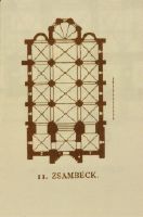
Zsambék, Klosterkirche, 2. H. saec. 13
Caption
Keyword photographer: floor plan. Title rider: Zsambék
Caption (German)
Schlagwort Bestandsbildner: Grundriss. Titel Reiter: Zsambék
Record Name
Dia_287-30474
Title (German)
Zsambék, Zsambék
Caption
Keyword photographer: floor plan. Title rider: Zsambék
Caption (German)
Schlagwort Bestandsbildner: Grundriss. Titel Reiter: Zsambék
Record Name
Dia_287-30475

Title (German)
Zuidbroek
Caption
Keyword photographer: floor plan. Title rider: Zuidbroek
Caption (German)
Schlagwort Bestandsbildner: Grundriss. Titel Reiter: Zuidbroek
Record Name
Dia_287-30476
Title (German)
Zuidbroek
Caption
Keyword photographer: floor plan. Title rider: Zuidbroek
Caption (German)
Schlagwort Bestandsbildner: Grundriss. Titel Reiter: Zuidbroek
Record Name
Dia_287-30477

Title (German)
Zürich, Grossmünster
Caption
Keyword photographer: floor plan. Title rider: Zurich; Grossmünster
Caption (German)
Schlagwort Bestandsbildner: Grundriss. Titel Reiter: Zürich; Grossmünster
Record Name
Dia_287-30478

Title (German)
Zürich, Grossmünster
Caption
Keyword photographer: floor plan. Title rider: Zurich; Grossmünster
Caption (German)
Schlagwort Bestandsbildner: Grundriss. Titel Reiter: Zürich; Grossmünster
Record Name
Dia_287-30479

Title (German)
Zürich, Grossmünster, Südliche Längsseite, nach Gutscher
Caption
Keyword photographer: floor plan. Title rider: Zurich; Grossmünster
Caption (German)
Schlagwort Bestandsbildner: Grundriss. Titel Reiter: Zürich; Grossmünster
Record Name
Dia_287-30480

Title (German)
Zürich, Grossmünster, Längsschnitt, nach Gutscher
Caption
Keyword photographer: floor plan. Title rider: Zurich; Grossmünster
Caption (German)
Schlagwort Bestandsbildner: Grundriss. Titel Reiter: Zürich; Grossmünster
Record Name
Dia_287-30481

Title (German)
Zürich, Grossmünster
Caption
Keyword photographer: floor plan. Title rider: Zurich; Grossmünster
Caption (German)
Schlagwort Bestandsbildner: Grundriss. Titel Reiter: Zürich; Grossmünster
Record Name
Dia_287-30482

Title (German)
Zürich, Grossmünster, Zürich
Caption
Keyword photographer: floor plan. Title rider: Zurich; Grossmünster
Caption (German)
Schlagwort Bestandsbildner: Grundriss. Titel Reiter: Zürich; Grossmünster
Record Name
Dia_287-30483

Title (German)
Zürich, Grossmünster, Nördliche Aussenseite mit Portal
Caption
Title rider: Zurich; Grossmünster
Caption (German)
Titel Reiter: Zürich; Grossmünster
Record Name
Dia_287-30484

Title (German)
Zürich, Grossmünster, Krypta
Caption
Title rider: Zurich; Grossmünster
Caption (German)
Titel Reiter: Zürich; Grossmünster
Record Name
Dia_287-30485

Title (German)
Zürich, Grossmünster
Caption
Title rider: Zurich; Grossmünster
Caption (German)
Titel Reiter: Zürich; Grossmünster
Record Name
Dia_287-30486

Title (German)
Zürich, Grossmünster
Caption
Title rider: Zurich; Grossmünster
Caption (German)
Titel Reiter: Zürich; Grossmünster
Record Name
Dia_287-30487

Title (German)
Zürich, Grossmünster
Caption
Title rider: Zurich; Grossmünster
Caption (German)
Titel Reiter: Zürich; Grossmünster
Record Name
Dia_287-30488

Title (German)
Zürich, Grossmünster
Caption
Title rider: Zurich; Grossmünster
Caption (German)
Titel Reiter: Zürich; Grossmünster
Record Name
Dia_287-30489

Title (German)
Zürich, Grossmünster
Caption
Title rider: Zurich; Grossmünster
Caption (German)
Titel Reiter: Zürich; Grossmünster
Record Name
Dia_287-30490

Title (German)
Zürich, St. Peter und Paul, Restaurierung, Statik
Caption
Title rider: Zurich; St. Peter and Paul
Caption (German)
Titel Reiter: Zürich; St. Peter und Paul
Record Name
Dia_287-30491

Title (German)
Zürich, St. Peter und Paul, Predigerchor von Norden
Caption
Title rider: Zurich; St. Peter and Paul
Caption (German)
Titel Reiter: Zürich; St. Peter und Paul
Record Name
Dia_287-30492

Title (German)
Zwettl, Chor
Caption
Keyword photographer: floor plan. Title rider: Zwettl
Caption (German)
Schlagwort Bestandsbildner: Grundriss. Titel Reiter: Zwettl
Record Name
Dia_287-30493

Title (German)
Zwettl, Zisterzienserkirche, Langhaus, Ausstattung
Caption
Title rider: Zwettl
Caption (German)
Titel Reiter: Zwettl
Record Name
Dia_287-30496

Title (German)
Zwettl, Zisterzienserkirche
Caption
Title rider: Zwettl
Caption (German)
Titel Reiter: Zwettl
Record Name
Dia_287-30497

Title (German)
Zwettl, Zisterzienserkirche
Caption
Title rider: Zwettl
Caption (German)
Titel Reiter: Zwettl
Record Name
Dia_287-30498

Title (German)
Zwettl, Langhaus nach Westen
Caption
Title rider: Zwettl
Caption (German)
Titel Reiter: Zwettl
Record Name
Dia_287-30499

Title (German)
Zwettl, Zisterzienserkirche
Caption
Title rider: Zwettl
Caption (German)
Titel Reiter: Zwettl
Record Name
Dia_287-30500

Title (German)
Zwettl, Zisterzienserkirche
Caption
Title rider: Zwettl
Caption (German)
Titel Reiter: Zwettl
Record Name
Dia_287-30501

Title (German)
Zwettl, Zisterzienserkirche
Caption
Title rider: Zwettl
Caption (German)
Titel Reiter: Zwettl
Record Name
Dia_287-30502

Title (German)
Zwettl, Zisterzienserkirche
Caption
Title rider: Zwettl
Caption (German)
Titel Reiter: Zwettl
Record Name
Dia_287-30503

Title (German)
Zwettl, Zisterzienserkirche
Caption
Title rider: Zwettl
Caption (German)
Titel Reiter: Zwettl
Record Name
Dia_287-30504

Title (German)
Zwettl, Zisterzienserkirche
Caption
Title rider: Zwettl. Blurred shot
Caption (German)
Titel Reiter: Zwettl. Unscharfe Aufnahme
Record Name
Dia_287-30505

Title (German)
Zwettl, Zisterzienserkirche
Caption
Title rider: Zwettl
Caption (German)
Titel Reiter: Zwettl
Record Name
Dia_287-30506

Title (German)
Zwettl, Zisterzienserkirche
Caption
Title rider: Zwettl
Caption (German)
Titel Reiter: Zwettl
Record Name
Dia_287-30507

Title (German)
Zwettl, Nähe, Totenlaterne
Caption
Title rider: Zwettl
Caption (German)
Titel Reiter: Zwettl
Record Name
Dia_287-30510

Title (German)
Zwettl, Nähe, Totenlaterne
Caption
Title rider: Zwettl
Caption (German)
Titel Reiter: Zwettl
Record Name
Dia_287-30511


Title (German)
Aachen, Dom
Caption
Photographer keyword: old and new
Caption (German)
Schlagwort Bestandsbildner: alt und neu
Record Name
Dia_287-31000

Title (German)
Aachen, Dom, Dom und St. Foillan
Caption
Photographer keyword: old and new
Caption (German)
Schlagwort Bestandsbildner: alt und neu
Record Name
Dia_287-31001

Title (German)
Aachen, Dom, Katschhof, Appelrath-Küpper
Caption
Photographer keyword: old and new
Caption (German)
Schlagwort Bestandsbildner: alt und neu
Record Name
Dia_287-31002

Title (German)
Aachen, Dom, W. Beschulte, Fenster neu
Caption
Photographer keyword: new building
Caption (German)
Schlagwort Bestandsbildner: Neubau
Record Name
Dia_287-31003

Title (German)
Aachen, Dom, St. Elisabeth, Maria Kathgrau, Fenster neu
Caption
Photographer keyword: new building
Caption (German)
Schlagwort Bestandsbildner: Neubau
Record Name
Dia_287-31004

Title (German)
Aachen, Dom, St. Elisabeth, Maria Kathgrau, Fenster neu
Caption
Photographer keyword: new building
Caption (German)
Schlagwort Bestandsbildner: Neubau
Record Name
Dia_287-31005

Title (German)
Aachen, Dom, St. Elisabeth, Maria Kathgrau, Fenster neu
Caption
Photographer keyword: new building
Caption (German)
Schlagwort Bestandsbildner: Neubau
Record Name
Dia_287-31006

Title (German)
Aachen, Dom, St. Elisabeth, Maria Kathgrau, Fenster neu
Caption
Photographer keyword: new building
Caption (German)
Schlagwort Bestandsbildner: Neubau
Record Name
Dia_287-31007

Title (German)
Aachen, Dom, St. Elisabeth, Maria Kathgrau, Fenster neu
Caption
Photographer keyword: new building
Caption (German)
Schlagwort Bestandsbildner: Neubau
Record Name
Dia_287-31008

Title (German)
Aachen, Dom, St. Foillan
Caption
Photographer keyword: old and new
Caption (German)
Schlagwort Bestandsbildner: alt und neu
Record Name
Dia_287-31009

Title (German)
Aachen, Dom, St. Foillan
Caption
Photographer keyword: old and new
Caption (German)
Schlagwort Bestandsbildner: alt und neu
Record Name
Dia_287-31010

Title (German)
Aachen, Dom, St. Foillan
Caption
Photographer keyword: old and new
Caption (German)
Schlagwort Bestandsbildner: alt und neu
Record Name
Dia_287-31011

Title (German)
Aachen, Dom, St. Foillan
Caption
Photographer keyword: old and new
Caption (German)
Schlagwort Bestandsbildner: alt und neu
Record Name
Dia_287-31012

Title (German)
Aachen, St. Jakob, St. Jakob, Neubau Sakristei, Architekt Leo Hugot
Caption
Photographer keyword: old and new
Caption (German)
Schlagwort Bestandsbildner: alt und neu
Record Name
Dia_287-31013

Title (German)
Aachen, St. Jakob, St. Jakob, Neubau Sakristei, Architekt Leo Hugot
Caption
Photographer keyword: old and new
Caption (German)
Schlagwort Bestandsbildner: alt und neu
Record Name
Dia_287-31014

Title (German)
Aachen, St. Marien, Neubau, Wiederaufbau
Caption
Photographer keyword: new building
Caption (German)
Schlagwort Bestandsbildner: Neubau
Record Name
Dia_287-31015

Title (German)
Aachen, St. Peter, Südeingang
Caption
Photographer keyword: old and new
Caption (German)
Schlagwort Bestandsbildner: alt und neu
Record Name
Dia_287-31016

Title (German)
Aachen, Rathaus
Caption
Photographer keyword: old and new
Caption (German)
Schlagwort Bestandsbildner: alt und neu
Record Name
Dia_287-31017

Title (German)
Aachen, Rathaus, Granusturm, Rekonstruktion
Caption
Photographer keyword: old and new
Caption (German)
Schlagwort Bestandsbildner: alt und neu
Record Name
Dia_287-31018

Title (German)
Aachen, Rathaus
Caption
Photographer keyword: old and new
Caption (German)
Schlagwort Bestandsbildner: alt und neu
Record Name
Dia_287-31019

Title (German)
Aachen, Rathaus, Krönungssaal
Caption
Photographer keyword: old and new
Caption (German)
Schlagwort Bestandsbildner: alt und neu
Record Name
Dia_287-31020
Title (German)
Aachen, Rathaus, Krönungssaal, Fenster von Ewald Mataré
Caption
Photographer keyword: old and new
Caption (German)
Schlagwort Bestandsbildner: alt und neu
Record Name
Dia_287-31021

Title (German)
Aachen, Rathaus, Ehemalige Apsis, neue Fenster von Ewald Mataré
Caption
Photographer keyword: old and new
Caption (German)
Schlagwort Bestandsbildner: alt und neu
Record Name
Dia_287-31022

Title (German)
Aachen, Rathaus, Standesamt und Granusturm
Caption
Photographer keyword: old and new
Caption (German)
Schlagwort Bestandsbildner: alt und neu
Record Name
Dia_287-31023

Title (German)
Aachen, Rathaus, Standesamt und "Apfelbaum"
Caption
Photographer keyword: old and new
Caption (German)
Schlagwort Bestandsbildner: alt und neu
Record Name
Dia_287-31024

Title (German)
Aachen, Rathaus, Standesamt, Neubau
Caption
Photographer keyword: new building
Caption (German)
Schlagwort Bestandsbildner: Neubau
Record Name
Dia_287-31025

Title (German)
Aachen, Klinikum, Neubau
Caption
Photographer keyword: new building
Caption (German)
Schlagwort Bestandsbildner: Neubau
Record Name
Dia_287-31026

Title (German)
Aachen, Kurhaus, Altes Kurhaus
Caption
Photographer keyword: old and new
Caption (German)
Schlagwort Bestandsbildner: alt und neu
Record Name
Dia_287-31027

Title (German)
Aachen, Annastrasse, Wiederaufbau
Caption
Photographer keyword: new building
Caption (German)
Schlagwort Bestandsbildner: Neubau
Record Name
Dia_287-31028

Title (German)
Aachen, Annastrasse, Badestein
Caption
Photographer keyword: old and new
Caption (German)
Schlagwort Bestandsbildner: alt und neu
Record Name
Dia_287-31029
![Aachen, Annastrasse, Bahkauf [Bahkauv], St. Foillan and Cathedral](thumbnails/thumb_ETHBIB.Bildarchiv_1298142.jpg)
Title (German)
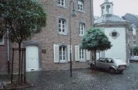
Aachen, Annastrasse, Bahkauf [Bahkauv], St. Foillan und Dom
Caption
Photographer keyword: old and new
Caption (German)
Schlagwort Bestandsbildner: alt und neu
Record Name
Dia_287-31030
![Aachen, Annastrasse, Bahkauf [Bahkauv], St. Foillan and Cathedral](thumbnails/thumb_ETHBIB.Bildarchiv_1298143.jpg)
Title (German)
Aachen, Annastrasse, Bahkauf [Bahkauv], St. Foillan und Dom
Caption
Photographer keyword: old and new
Caption (German)
Schlagwort Bestandsbildner: alt und neu
Record Name
Dia_287-31031

Title (German)
Aachen, Bendelstrasse, Neubau, Neubauten
Caption
Photographer keyword: new building
Caption (German)
Schlagwort Bestandsbildner: Neubau
Record Name
Dia_287-31032

Title (German)
Aachen, Bendelstrasse, Hofbebauung, Neubau: Historismus
Caption
Photographer keyword: new building
Caption (German)
Schlagwort Bestandsbildner: Neubau
Record Name
Dia_287-31033

Title (German)
Aachen, Bendelstrasse, Neubauten
Caption
Photographer keyword: new building
Caption (German)
Schlagwort Bestandsbildner: Neubau
Record Name
Dia_287-31034
Title (German)
Aachen, Bendelstrasse, Neubauten, Imitation
Caption
Photographer keyword: new building
Caption (German)
Schlagwort Bestandsbildner: Neubau
Record Name
Dia_287-31036

Title (German)
Aachen, Bendelstrasse, Neubau Historismus
Caption
Photographer keyword: new building
Caption (German)
Schlagwort Bestandsbildner: Neubau
Record Name
Dia_287-31037

Title (German)
Aachen, Bendelstrasse, Hofbebauung, Neubauten
Caption
Photographer keyword: new building
Caption (German)
Schlagwort Bestandsbildner: Neubau
Record Name
Dia_287-31038

Title (German)
Aachen, Bendelstrasse, 1 Nuebau
Caption
Photographer keyword: new building
Caption (German)
Schlagwort Bestandsbildner: Neubau
Record Name
Dia_287-31039

Title (German)
Aachen, Bendelstrasse, Neubauten
Caption
Photographer keyword: new building
Caption (German)
Schlagwort Bestandsbildner: Neubau
Record Name
Dia_287-31040

Title (German)
Aachen, Büchel
Caption
Photographer keyword: old and new
Caption (German)
Schlagwort Bestandsbildner: alt und neu
Record Name
Dia_287-31041

Title (German)
Aachen, Büchel
Caption
Photographer keyword: old and new
Caption (German)
Schlagwort Bestandsbildner: alt und neu
Record Name
Dia_287-31042

Title (German)
Aachen, Büchel
Caption
Photographer keyword: old and new
Caption (German)
Schlagwort Bestandsbildner: alt und neu
Record Name
Dia_287-31043

Title (German)
Aachen, Büchel
Caption
Photographer keyword: old and new
Caption (German)
Schlagwort Bestandsbildner: alt und neu
Record Name
Dia_287-31044

Title (German)
Aachen, Büchel
Caption
Photographer keyword: old and new
Caption (German)
Schlagwort Bestandsbildner: alt und neu
Record Name
Dia_287-31045

Title (German)
Aachen, Büchel, Büchel mit Dom
Caption
Photographer keyword: old and new
Caption (German)
Schlagwort Bestandsbildner: alt und neu
Record Name
Dia_287-31046

Title (German)
Aachen, Büchel, Büchel, Neubau
Caption
Photographer keyword: old and new
Caption (German)
Schlagwort Bestandsbildner: alt und neu
Record Name
Dia_287-31047

Title (German)
Aachen, Büchel, Büchel, Neubau
Caption
Photographer keyword: old and new
Caption (German)
Schlagwort Bestandsbildner: alt und neu
Record Name
Dia_287-31048

Title (German)
Aachen, Büchel, Büchel, Neubau
Caption
Photographer keyword: old and new
Caption (German)
Schlagwort Bestandsbildner: alt und neu
Record Name
Dia_287-31049

Title (German)
Aachen, Büchel, Büchel mit Dom
Caption
Photographer keyword: old and new
Caption (German)
Schlagwort Bestandsbildner: alt und neu
Record Name
Dia_287-31050

Title (German)
Aachen, Büchel, Neubau 80er Jahre
Caption
Photographer keyword: new building
Caption (German)
Schlagwort Bestandsbildner: Neubau
Record Name
Dia_287-31051

Title (German)
Aachen, Büchel, Neubau 80er Jahre
Caption
Photographer keyword: new building
Caption (German)
Schlagwort Bestandsbildner: Neubau
Record Name
Dia_287-31052

Title (German)
Aachen, Büchel, Parkhaus, Verkehr
Caption
Photographer keyword: old and new
Caption (German)
Schlagwort Bestandsbildner: alt und neu
Record Name
Dia_287-31053

Title (German)
Aachen, Büchel, Parkhaus, Verkehr
Caption
Photographer keyword: old and new
Caption (German)
Schlagwort Bestandsbildner: alt und neu
Record Name
Dia_287-31054

Title (German)
Aachen, Büchel, Parkhaus, Nutzung
Caption
Photographer keyword: old and new
Caption (German)
Schlagwort Bestandsbildner: alt und neu
Record Name
Dia_287-31055

Title (German)
Aachen, Büchel, Ludwigsallee, Neubau 50 J.
Caption
Photographer keyword: old and new
Caption (German)
Schlagwort Bestandsbildner: alt und neu
Record Name
Dia_287-31056

Title (German)
Aachen, Dahmengraben, Neubau
Caption
Photographer keyword: old and new
Caption (German)
Schlagwort Bestandsbildner: alt und neu
Record Name
Dia_287-31057

Title (German)
Aachen, Dahmengraben, Neubau
Caption
Photographer keyword: new building
Caption (German)
Schlagwort Bestandsbildner: Neubau
Record Name
Dia_287-31058

Title (German)
Aachen, Dahmengraben, Neubau, Drogerie, Architekt Haas
Caption
Photographer keyword: new building
Caption (German)
Schlagwort Bestandsbildner: Neubau
Record Name
Dia_287-31059

Title (German)
Aachen, Dahmengraben, Neubau
Caption
Photographer keyword: new building
Caption (German)
Schlagwort Bestandsbildner: Neubau
Record Name
Dia_287-31060

Title (German)
Aachen, Dahmengraben, Neubau, Drogerie, Architekt Haas
Caption
Photographer keyword: new building
Caption (German)
Schlagwort Bestandsbildner: Neubau
Record Name
Dia_287-31061

Title (German)
Aachen, Deliusstrasse, Rückseite der Fabrik
Caption
Photographer keyword: old and new
Caption (German)
Schlagwort Bestandsbildner: alt und neu
Record Name
Dia_287-31062

Title (German)
Aachen, Domhof, Mit Taufkapelle
Caption
Photographer keyword: old and new
Caption (German)
Schlagwort Bestandsbildner: alt und neu
Record Name
Dia_287-31063

Title (German)
Aachen, Domhof, Barbarossamauer
Caption
Photographer keyword: old and new
Caption (German)
Schlagwort Bestandsbildner: alt und neu
Record Name
Dia_287-31064

Title (German)
Aachen, Hof, Neubau, H. Haas
Caption
Photographer keyword: old and new
Caption (German)
Schlagwort Bestandsbildner: alt und neu
Record Name
Dia_287-31065

Title (German)
Aachen, Hof, Haus der Kohle
Caption
Photographer keyword: old and new
Caption (German)
Schlagwort Bestandsbildner: alt und neu
Record Name
Dia_287-31066

Title (German)
Aachen, Hühnermarkt, Hühnersmahl "Apfelbaum"
Caption
Photographer keyword: new building
Caption (German)
Schlagwort Bestandsbildner: Neubau
Record Name
Dia_287-31067

Title (German)
Aachen, Jakobstrasse
Caption
Photographer keyword: old and new
Caption (German)
Schlagwort Bestandsbildner: alt und neu
Record Name
Dia_287-31068

Title (German)
Aachen, Jakobstrasse, Hofseite
Caption
Photographer keyword: old and new
Caption (German)
Schlagwort Bestandsbildner: alt und neu
Record Name
Dia_287-31069

Title (German)
Aachen, Jakobstrasse
Caption
Photographer keyword: old and new
Caption (German)
Schlagwort Bestandsbildner: alt und neu
Record Name
Dia_287-31070

Title (German)
Aachen, Jakobstrasse
Caption
Photographer keyword: old and new
Caption (German)
Schlagwort Bestandsbildner: alt und neu
Record Name
Dia_287-31071

Title (German)
Aachen, Jakobstrasse, Neubauten; Regionalismus
Caption
Photographer keyword: new building
Caption (German)
Schlagwort Bestandsbildner: Neubau
Record Name
Dia_287-31072

Title (German)
Aachen, Jakobstrasse, Wiederaufbau
Caption
Photographer keyword: new building
Caption (German)
Schlagwort Bestandsbildner: Neubau
Record Name
Dia_287-31073

Title (German)
Aachen, Judenviertel, Judenviertel "Säule", Neubau "Eklektizismus"
Caption
Photographer keyword: new building
Caption (German)
Schlagwort Bestandsbildner: Neubau
Record Name
Dia_287-31074

Title (German)
Aachen, Klostergasse, Neubau
Caption
Photographer keyword: old and new
Caption (German)
Schlagwort Bestandsbildner: alt und neu
Record Name
Dia_287-31076

Title (German)
Aachen, Klostergasse, Neubau
Caption
Photographer keyword: old and new
Caption (German)
Schlagwort Bestandsbildner: alt und neu
Record Name
Dia_287-31077
Title (German)
Aachen, Klappergasse, Neubau
Caption
Photographer keyword: new building
Caption (German)
Schlagwort Bestandsbildner: Neubau
Record Name
Dia_287-31078

Title (German)
Aachen, Klappergasse, Neubau (Regionalismus)
Caption
Photographer keyword: new building
Caption (German)
Schlagwort Bestandsbildner: Neubau
Record Name
Dia_287-31079

Title (German)
Aachen, Klappergasse, Haus der Kähle, St. Foillan
Caption
Photographer keyword: old and new
Caption (German)
Schlagwort Bestandsbildner: alt und neu
Record Name
Dia_287-31080

Title (German)
Aachen, Königstrasse, Neuer Backsteinbau
Caption
Photographer keyword: old and new
Caption (German)
Schlagwort Bestandsbildner: alt und neu
Record Name
Dia_287-31081

Title (German)
Aachen, Körbergasse, Translozierung
Caption
Photographer keyword: old and new
Caption (German)
Schlagwort Bestandsbildner: alt und neu
Record Name
Dia_287-31082

Title (German)
Aachen, Körbergasse, Körbergässchen
Caption
Photographer keyword: old and new
Caption (German)
Schlagwort Bestandsbildner: alt und neu
Record Name
Dia_287-31083

Title (German)
Aachen, Körbergasse
Caption
Photographer keyword: old and new
Caption (German)
Schlagwort Bestandsbildner: alt und neu
Record Name
Dia_287-31084

Title (German)
Aachen, Körbergasse, Körbergässchen
Caption
Photographer keyword: old and new
Caption (German)
Schlagwort Bestandsbildner: alt und neu
Record Name
Dia_287-31085

Title (German)
Aachen, Kärmerstrasse, Appelrathaus-Kirche
Caption
Photographer keyword: old and new
Caption (German)
Schlagwort Bestandsbildner: alt und neu
Record Name
Dia_287-31086

Title (German)
Aachen, Kärmerstrasse, Transloziertes Haus (H. Haas)
Caption
Photographer keyword: old and new
Caption (German)
Schlagwort Bestandsbildner: alt und neu
Record Name
Dia_287-31087

Title (German)
Aachen, Ludwigsallee, Neubau 50er Jahre
Caption
Photographer keyword: old and new
Caption (German)
Schlagwort Bestandsbildner: alt und neu
Record Name
Dia_287-31088
Title (German)
Aachen, Ludwigsallee
Caption
Photographer keyword: old and new
Caption (German)
Schlagwort Bestandsbildner: alt und neu
Record Name
Dia_287-31089

Title (German)
Aachen, Ludwigsallee
Caption
Photographer keyword: old and new
Caption (German)
Schlagwort Bestandsbildner: alt und neu
Record Name
Dia_287-31090

Title (German)
Aachen, Markt
Caption
Photographer keyword: old and new
Caption (German)
Schlagwort Bestandsbildner: alt und neu
Record Name
Dia_287-31091

Title (German)
Aachen, Markt, Büchel
Caption
Photographer keyword: old and new
Caption (German)
Schlagwort Bestandsbildner: alt und neu
Record Name
Dia_287-31092

Title (German)
Aachen, Markt
Caption
Photographer keyword: old and new
Caption (German)
Schlagwort Bestandsbildner: alt und neu
Record Name
Dia_287-31093

Title (German)
Aachen, Markt, Hr. Löwenstein, Apotheke, ADK
Caption
Photographer keyword: old and new
Caption (German)
Schlagwort Bestandsbildner: alt und neu
Record Name
Dia_287-31094

Title (German)
Aachen, Markt, Markt, Neubau
Caption
Photographer keyword: old and new
Caption (German)
Schlagwort Bestandsbildner: alt und neu
Record Name
Dia_287-31095

Title (German)
Aachen, Mostardstrasse, Neubauten
Caption
Photographer keyword: new building
Caption (German)
Schlagwort Bestandsbildner: Neubau
Record Name
Dia_287-31096

Title (German)
Aachen, Münsterplatz, Münsterplatz (?)
Caption
Photographer keyword: new building
Caption (German)
Schlagwort Bestandsbildner: Neubau
Record Name
Dia_287-31097

Title (German)
Aachen, Neupforte, Neupforte, Neubau
Caption
Photographer keyword: new building
Caption (German)
Schlagwort Bestandsbildner: Neubau
Record Name
Dia_287-31098

Title (German)
Aachen, Peterstrasse, Busbahnhof, Neubauten
Caption
Photographer keyword: new building
Caption (German)
Schlagwort Bestandsbildner: Neubau
Record Name
Dia_287-31099

Title (German)
Aachen, Peterstrasse, Busbahnhof, Neubauten, Sanierung
Caption
Photographer keyword: new building
Caption (German)
Schlagwort Bestandsbildner: Neubau
Record Name
Dia_287-31100

Title (German)
Aachen, Peterstrasse, Parzellen, Neubauten
Caption
Photographer keyword: new building
Caption (German)
Schlagwort Bestandsbildner: Neubau
Record Name
Dia_287-31101

Title (German)
Aachen, Pontstrasse, Pontstrasse 170, Neubau
Caption
Photographer keyword: new building
Caption (German)
Schlagwort Bestandsbildner: Neubau
Record Name
Dia_287-31102

Title (German)
Aachen, Pontstrasse, Pontstrasse 170, Neubau
Caption
Photographer keyword: new building
Caption (German)
Schlagwort Bestandsbildner: Neubau
Record Name
Dia_287-31103

Title (German)
Aachen, Pontstrasse, Apsis Apsis d. karol. Palas, Fenster von Ewald Matré
Caption
Photographer keyword: old and new
Caption (German)
Schlagwort Bestandsbildner: alt und neu
Record Name
Dia_287-31104

Title (German)
Aachen, Regierung, Regierung "Betonprotest", Neubau
Caption
Photographer keyword: new building
Caption (German)
Schlagwort Bestandsbildner: Neubau
Record Name
Dia_287-31105

Title (German)
Aachen, Regierung, Regierung "Betonprotest", Neubau
Caption
Photographer keyword: new building
Caption (German)
Schlagwort Bestandsbildner: Neubau
Record Name
Dia_287-31106

Title (German)
Aachen, Rennbahn
Caption
Photographer keyword: new building
Caption (German)
Schlagwort Bestandsbildner: Neubau
Record Name
Dia_287-31107

Title (German)
Aachen, Rennbahn, Ritter-Chorusstrasse, 50er Jahre, Neubau
Caption
Photographer keyword: new building
Caption (German)
Schlagwort Bestandsbildner: Neubau
Record Name
Dia_287-31108

Title (German)
Aachen, Roosviertel
Caption
Photographer keyword: new building
Caption (German)
Schlagwort Bestandsbildner: Neubau
Record Name
Dia_287-31109
Title (German)
Aachen, Roosviertel, Rooskapellchen, Neubau
Caption
Photographer keyword: new building
Caption (German)
Schlagwort Bestandsbildner: Neubau
Record Name
Dia_287-31110

Title (German)
Aachen, Roosviertel, Rooskapellchen, Sanierung, Neubauten
Caption
Photographer keyword: new building
Caption (German)
Schlagwort Bestandsbildner: Neubau
Record Name
Dia_287-31111

Title (German)
Aachen, Rütscherstrasse, Rütscherstrasse 34
Caption
Photographer keyword: old and new
Caption (German)
Schlagwort Bestandsbildner: alt und neu
Record Name
Dia_287-31112

Title (German)
Aachen, Rütscherstrasse, Rütscherstrasse 34
Caption
Photographer keyword: old and new
Caption (German)
Schlagwort Bestandsbildner: alt und neu
Record Name
Dia_287-31113

Title (German)
Aachen, Rütscherstrasse, Rütscherstrasse 34
Caption
Photographer keyword: old and new
Caption (German)
Schlagwort Bestandsbildner: alt und neu
Record Name
Dia_287-31114

Title (German)
Aachen, Rütscherstrasse, Rütscherstrasse 34
Caption
Photographer keyword: old and new
Caption (German)
Schlagwort Bestandsbildner: alt und neu
Record Name
Dia_287-31115

Title (German)
Aachen, Rütscherstrasse, Rütscherstrasse 34
Caption
Photographer keyword: old and new
Caption (German)
Schlagwort Bestandsbildner: alt und neu
Record Name
Dia_287-31116

Title (German)
Aachen, Vaalserquartier, Neubauten, Historismus (20er Jahre)
Caption
Photographer keyword: new building
Caption (German)
Schlagwort Bestandsbildner: Neubau
Record Name
Dia_287-31117

Title (German)
Aachen, Vaalserquartier, Neubauten
Caption
Photographer keyword: new building
Caption (German)
Schlagwort Bestandsbildner: Neubau
Record Name
Dia_287-31118

Title (German)
Aachen, Vaalserquartier, Bauhof, Schützenhaus
Caption
Photographer keyword: old and new
Caption (German)
Schlagwort Bestandsbildner: alt und neu
Record Name
Dia_287-31119

Title (German)
Aachen, Wirichsbongardstrasse, Wirichsborngardstrasse
Caption
Photographer keyword: old and new
Caption (German)
Schlagwort Bestandsbildner: alt und neu
Record Name
Dia_287-31120

Title (German)
Aachen, Wirichsbongardstrasse, Neubau
Caption
Photographer keyword: new building
Caption (German)
Schlagwort Bestandsbildner: Neubau
Record Name
Dia_287-31121

Title (German)
Aachen, Wirichsbongardstrasse, Buntscheid Hs. Schmidt-Gielsdorf
Caption
Photographer keyword: new building
Caption (German)
Schlagwort Bestandsbildner: Neubau
Record Name
Dia_287-31122

Title (German)
Aachen, Wirichsbongardstrasse, Backsteinneubau, Pflaster
Caption
Photographer keyword: new building
Caption (German)
Schlagwort Bestandsbildner: Neubau
Record Name
Dia_287-31123

Title (German)
Aachen, Wirichsbongardstrasse, Neubauten
Caption
Photographer keyword: new building
Caption (German)
Schlagwort Bestandsbildner: Neubau
Record Name
Dia_287-31124

Title (German)
Aachen, Wirichsbongardstrasse, Rückseitige Neubauten
Caption
Photographer keyword: new building
Caption (German)
Schlagwort Bestandsbildner: Neubau
Record Name
Dia_287-31125

Title (German)
Aachen, Wirichsbongardstrasse, Neues Dreifensterhaus, Massstäblichkeit, Backstein
Caption
Photographer keyword: new building
Caption (German)
Schlagwort Bestandsbildner: Neubau
Record Name
Dia_287-31126

Title (German)
Aachen, Wirichsbongardstrasse, Neubauecke
Caption
Photographer keyword: new building
Caption (German)
Schlagwort Bestandsbildner: Neubau
Record Name
Dia_287-31127

Title (German)
Aachen, Wirichsbongardstrasse, Neubau an St. Peter
Caption
Photographer keyword: old and new
Caption (German)
Schlagwort Bestandsbildner: alt und neu
Record Name
Dia_287-31128

Title (German)
Aachen, Wirichsbongardstrasse, Fenster in Putzbau
Caption
Photographer keyword: old and new
Caption (German)
Schlagwort Bestandsbildner: alt und neu
Record Name
Dia_287-31129

Title (German)
Aachen-Burtscheid, Haus Schmidt-Gielsdorf
Caption
Photographer keyword: new building
Caption (German)
Schlagwort Bestandsbildner: Neubau
Record Name
Dia_287-31130

Title (German)
Aadorf-Tänikon, Neubauten
Caption
Photographer keyword: new building
Caption (German)
Schlagwort Bestandsbildner: Neubau
Record Name
Dia_287-31131

Title (German)
Aadorf-Tänikon, Eidgenössische Forschungsanstalt
Caption
Photographer keyword: old and new
Caption (German)
Schlagwort Bestandsbildner: alt und neu
Record Name
Dia_287-31132

Title (German)
Aadorf-Tänikon, Eidgenössische Forschungsanstalt
Caption
Photographer keyword: old and new
Caption (German)
Schlagwort Bestandsbildner: alt und neu
Record Name
Dia_287-31133

Title (German)
Aadorf-Tänikon, Pflaster, Beleuchtung, eidgenössische Forschungsanstalt
Caption
Photographer keyword: old and new
Caption (German)
Schlagwort Bestandsbildner: alt und neu
Record Name
Dia_287-31134

Title (German)
Aadorf-Tänikon, Eidgenössische Forschungsanstalt
Caption
Photographer keyword: old and new
Caption (German)
Schlagwort Bestandsbildner: alt und neu
Record Name
Dia_287-31135

Title (German)
Aadorf-Tänikon, Wohnbau, eidgenössische Forschungsanstalt
Caption
Photographer keyword: old and new
Caption (German)
Schlagwort Bestandsbildner: alt und neu
Record Name
Dia_287-31136

Title (German)
Aarau, ehemaliger Bauhof, Ehemaliger Bauhof, Schützenhaus
Caption
Photographer keyword: old and new
Caption (German)
Schlagwort Bestandsbildner: alt und neu
Record Name
Dia_287-31137

Title (German)
Aarau, ehemaliger Bauhof, Ehemaliger Bauhof, Schützenhaus
Caption
Photographer keyword: old and new
Caption (German)
Schlagwort Bestandsbildner: alt und neu
Record Name
Dia_287-31138

Title (German)
Aarau, ehemaliger Bauhof, Ehemaliger Bauhof, Schützenhaus
Caption
Photographer keyword: old and new
Caption (German)
Schlagwort Bestandsbildner: alt und neu
Record Name
Dia_287-31139

Title (German)
Aarau, ehemaliger Bauernhof
Caption
Photographer keyword: old and new
Caption (German)
Schlagwort Bestandsbildner: alt und neu
Record Name
Dia_287-31140

Title (German)
Aarau, ehemaliger Bauernhof
Caption
Photographer keyword: old and new
Caption (German)
Schlagwort Bestandsbildner: alt und neu
Record Name
Dia_287-31141

Title (German)
Aarau, ehemaliger Bauernhof
Caption
Photographer keyword: old and new
Caption (German)
Schlagwort Bestandsbildner: alt und neu
Record Name
Dia_287-31142

Title (German)
Aarau, ehemaliger Bauernhof
Caption
Photographer keyword: old and new
Caption (German)
Schlagwort Bestandsbildner: alt und neu
Record Name
Dia_287-31143

Title (German)
Aarau, am Rhein, Rain 26, Lage in der Altstadt
Caption
Photographer keyword: old and new
Caption (German)
Schlagwort Bestandsbildner: alt und neu
Record Name
Dia_287-31144

Title (German)
Aarau, am Rhein, Rain 26, Neubaupläne
Caption
Photographer keyword: old and new
Caption (German)
Schlagwort Bestandsbildner: alt und neu
Record Name
Dia_287-31145

Title (German)
Aarau, am Rhein, Rain 26, Neubaupläne
Caption
Photographer keyword: old and new
Caption (German)
Schlagwort Bestandsbildner: alt und neu
Record Name
Dia_287-31146

Title (German)
Aarau, am Rhein, Rain 26, Baustelle
Caption
Photographer keyword: old and new
Caption (German)
Schlagwort Bestandsbildner: alt und neu
Record Name
Dia_287-31147

Title (German)
Aarau, am Rhein, Rain 26
Caption
Photographer keyword: old and new
Caption (German)
Schlagwort Bestandsbildner: alt und neu
Record Name
Dia_287-31148

Title (German)
Aarau, am Rhein, Rain 26
Caption
Photographer keyword: old and new
Caption (German)
Schlagwort Bestandsbildner: alt und neu
Record Name
Dia_287-31149

Title (German)
Aarau, am Rhein, Baustelle Haus Rain 26
Caption
Photographer keyword: old and new
Caption (German)
Schlagwort Bestandsbildner: alt und neu
Record Name
Dia_287-31150

Title (German)
Aarau, am Rhein, Rain 26, Baustelle
Caption
Photographer keyword: old and new
Caption (German)
Schlagwort Bestandsbildner: alt und neu
Record Name
Dia_287-31151

Title (German)
Aarau, am Rhein, Am Rain 26
Caption
Photographer keyword: old and new
Caption (German)
Schlagwort Bestandsbildner: alt und neu
Record Name
Dia_287-31153

Title (German)
Aarau, am Rhein, Am Rain 26
Caption
Photographer keyword: old and new
Caption (German)
Schlagwort Bestandsbildner: alt und neu
Record Name
Dia_287-31154

Title (German)
Aarau, am Rhein, Am Rain 26
Caption
Photographer keyword: old and new
Caption (German)
Schlagwort Bestandsbildner: alt und neu
Record Name
Dia_287-31155

Title (German)
Aarau, am Rhein, Am Rain 26
Caption
Photographer keyword: old and new
Caption (German)
Schlagwort Bestandsbildner: alt und neu
Record Name
Dia_287-31156

Title (German)
Aarau, am Rhein, Am Rein 26, Neubau (Frey und Frey)
Caption
Photographer keyword: old and new
Caption (German)
Schlagwort Bestandsbildner: alt und neu
Record Name
Dia_287-31157

Title (German)
Aarau, am Rhein, Am Rain 26
Caption
Photographer keyword: old and new
Caption (German)
Schlagwort Bestandsbildner: alt und neu
Record Name
Dia_287-31158

Title (German)
Aarau, am Rhein, Am Rain 26
Caption
Photographer keyword: old and new
Caption (German)
Schlagwort Bestandsbildner: alt und neu
Record Name
Dia_287-31159

Title (German)
Aarau, am Rhein, Am Rain 26, Frey Architekten
Caption
Photographer keyword: old and new
Caption (German)
Schlagwort Bestandsbildner: alt und neu
Record Name
Dia_287-31160

Title (German)
Aarau, am Rhein, Am Rain 26, Neubau (Frey und Frey)
Caption
Photographer keyword: old and new
Caption (German)
Schlagwort Bestandsbildner: alt und neu
Record Name
Dia_287-31161

Title (German)
Aarau, am Rhein, Am Rain 26
Caption
Photographer keyword: old and new
Caption (German)
Schlagwort Bestandsbildner: alt und neu
Record Name
Dia_287-31162

Title (German)
Aarau, am Rhein, Rain, Tür am Haus neben Rain 26
Caption
Photographer keyword: old and new
Caption (German)
Schlagwort Bestandsbildner: alt und neu
Record Name
Dia_287-31163

Title (German)
Aarau, am Rhein, Rain, Tür am Haus neben Rain 26
Caption
Photographer keyword: old and new
Caption (German)
Schlagwort Bestandsbildner: alt und neu
Record Name
Dia_287-31164

Title (German)
Aarau, am Rhein, Am Rain 26, Vorfenster
Caption
Photographer keyword: old and new
Caption (German)
Schlagwort Bestandsbildner: alt und neu
Record Name
Dia_287-31165

Title (German)
Aarau, am Rhein, Am Rain 26
Caption
Photographer keyword: old and new
Caption (German)
Schlagwort Bestandsbildner: alt und neu
Record Name
Dia_287-31166

Title (German)
Aarau, am Rhein, Am Rain 26, Fenster
Caption
Photographer keyword: old and new
Caption (German)
Schlagwort Bestandsbildner: alt und neu
Record Name
Dia_287-31167

Title (German)
Aarau, am Rhein, Am Rain 26, Neubau (Frey und Frey)
Caption
Photographer keyword: old and new
Caption (German)
Schlagwort Bestandsbildner: alt und neu
Record Name
Dia_287-31168

Title (German)
Aarau, am Rhein, Am Rain 26, Neubau (Frey und Frey)
Caption
Photographer keyword: old and new
Caption (German)
Schlagwort Bestandsbildner: alt und neu
Record Name
Dia_287-31169

Title (German)
Aarau, am Rhein, Am Rain 26, Neubau (Frey und Frey)
Caption
Photographer keyword: old and new
Caption (German)
Schlagwort Bestandsbildner: alt und neu
Record Name
Dia_287-31170

Title (German)
Aarau, am Rhein, Am Rain 26, Neubau (Frey und Frey)
Caption
Photographer keyword: old and new
Caption (German)
Schlagwort Bestandsbildner: alt und neu
Record Name
Dia_287-31171

Title (German)
Aarau, am Rhein, Am Rain 26, Neubau (Frey und Frey)
Caption
Photographer keyword: old and new
Caption (German)
Schlagwort Bestandsbildner: alt und neu
Record Name
Dia_287-31172

Title (German)
Aarau, am Rhein, Am Rain 26, Neubau (Frey und Frey)
Caption
Photographer keyword: old and new
Caption (German)
Schlagwort Bestandsbildner: alt und neu
Record Name
Dia_287-31173

Title (German)
Aarau, am Rhein, Am Rain 26, Neubau (Frey und Frey)
Caption
Photographer keyword: old and new
Caption (German)
Schlagwort Bestandsbildner: alt und neu
Record Name
Dia_287-31174

Title (German)
Aarau, am Rhein, Am Rain 26, Neubau (Frey und Frey)
Caption
Photographer keyword: old and new
Caption (German)
Schlagwort Bestandsbildner: alt und neu
Record Name
Dia_287-31175

Title (German)
Aarau, am Rhein, Am Rain 26, Neubau (Frey und Frey)
Caption
Photographer keyword: old and new
Caption (German)
Schlagwort Bestandsbildner: alt und neu
Record Name
Dia_287-31176

Title (German)
Aarau, Färbeplatz
Caption
Photographer keyword: old and new
Caption (German)
Schlagwort Bestandsbildner: alt und neu
Record Name
Dia_287-31177

Title (German)
Aarau, Färbeplatz
Caption
Photographer keyword: old and new
Caption (German)
Schlagwort Bestandsbildner: alt und neu
Record Name
Dia_287-31178

Title (German)
Aarau, Varia, Nebau in der Altstadt
Caption
Photographer keyword: old and new
Caption (German)
Schlagwort Bestandsbildner: alt und neu
Record Name
Dia_287-31179

Title (German)
Aarau, Varia, Hotel Royal, neuer Eingang
Caption
Photographer keyword: old and new
Caption (German)
Schlagwort Bestandsbildner: alt und neu
Record Name
Dia_287-31180

Title (German)
Adelschlag, Katholische Kirche, Karl Joseph Schattner
Caption
Photographer keyword: old and new
Caption (German)
Schlagwort Bestandsbildner: alt und neu
Record Name
Dia_287-31181

Title (German)
Adelschlag, Katholische Kirche, Karl Joseph Schattner
Caption
Photographer keyword: old and new
Caption (German)
Schlagwort Bestandsbildner: alt und neu
Record Name
Dia_287-31182

Title (German)
Adelschlag, Katholische Kirche, Karl Joseph Schattner
Caption
Photographer keyword: old and new
Caption (German)
Schlagwort Bestandsbildner: alt und neu
Record Name
Dia_287-31183

Title (German)
Adelschlag, Katholische Kirche, Karl Joseph Schattner
Caption
Photographer keyword: old and new
Caption (German)
Schlagwort Bestandsbildner: alt und neu
Record Name
Dia_287-31184

Title (German)
Adelschlag, Katholische Kirche, Karl Joseph Schattner
Caption
Photographer keyword: old and new
Caption (German)
Schlagwort Bestandsbildner: alt und neu
Record Name
Dia_287-31185

Title (German)
Adelschlag, Katholische Kirche, Karl Joseph Schattner
Caption
Photographer keyword: old and new
Caption (German)
Schlagwort Bestandsbildner: alt und neu
Record Name
Dia_287-31186

Title (German)
Adelschlag, Katholische Kirche, Karl Joseph Schattner
Caption
Photographer keyword: old and new
Caption (German)
Schlagwort Bestandsbildner: alt und neu
Record Name
Dia_287-31187

Title (German)
Adelschlag, Katholische Kirche, Karl Joseph Schattner
Caption
Photographer keyword: old and new
Caption (German)
Schlagwort Bestandsbildner: alt und neu
Record Name
Dia_287-31188

Title (German)
Adelschlag, Katholische Kirche, Karl Joseph Schattner
Caption
Photographer keyword: old and new
Caption (German)
Schlagwort Bestandsbildner: alt und neu
Record Name
Dia_287-31189

Title (German)
Adelschlag, Katholische Kirche, Karl Joseph Schattner
Caption
Photographer keyword: old and new
Caption (German)
Schlagwort Bestandsbildner: alt und neu
Record Name
Dia_287-31190

Title (German)
Adelschlag, Katholische Kirche, Karl Joseph Schattner
Caption
Photographer keyword: old and new
Caption (German)
Schlagwort Bestandsbildner: alt und neu
Record Name
Dia_287-31191

Title (German)
Adelschlag, Katholische Kirche, Karl Joseph Schattner
Caption
Photographer keyword: old and new
Caption (German)
Schlagwort Bestandsbildner: alt und neu
Record Name
Dia_287-31192

Title (German)
Adliswil, Überbauung, Architekt Santschi
Caption
Photographer keyword: new building
Caption (German)
Schlagwort Bestandsbildner: Neubau
Record Name
Dia_287-31193

Title (German)
Adliswil, Überbauung, Architekt Santschi
Caption
Photographer keyword: new building
Caption (German)
Schlagwort Bestandsbildner: Neubau
Record Name
Dia_287-31194

Title (German)
Adliswil, Überbauung, Architekt Santschi
Caption
Photographer keyword: new building
Caption (German)
Schlagwort Bestandsbildner: Neubau
Record Name
Dia_287-31195

Title (German)
Allensbach, Holzhaus von Herbert Schaudt, Ensemble
Caption
Photographer keyword: new building
Caption (German)
Schlagwort Bestandsbildner: Neubau
Record Name
Dia_287-31196

Title (German)
Allensbach, Holzhaus von Herbert Schaudt
Caption
Photographer keyword: new building
Caption (German)
Schlagwort Bestandsbildner: Neubau
Record Name
Dia_287-31197

Title (German)
Allensbach, Holzhaus von Herbert Schaudt
Caption
Photographer keyword: new building
Caption (German)
Schlagwort Bestandsbildner: Neubau
Record Name
Dia_287-31198

Title (German)
Allensbach, Holzhaus von Herbert Schaudt
Caption
Photographer keyword: new building
Caption (German)
Schlagwort Bestandsbildner: Neubau
Record Name
Dia_287-31199

Title (German)
Zeichnung Johannes h. mit Briefmarke Kongo
Caption
Photographer keyword: old and new
Caption (German)
Schlagwort Bestandsbildner: alt und neu
Record Name
Dia_287-31200

Title (German)
Altdorf, Türmli, Wettbewerb, Hofzone
Caption
Photographer keyword: old and new
Caption (German)
Schlagwort Bestandsbildner: alt und neu
Record Name
Dia_287-31201

Title (German)
Altdorf, Türmli, Wettbewerb, Hofzone
Caption
Photographer keyword: old and new
Caption (German)
Schlagwort Bestandsbildner: alt und neu
Record Name
Dia_287-31202

Title (German)
Altdorf, Türmli, Wettbewerb, Hofzone
Caption
Photographer keyword: old and new
Caption (German)
Schlagwort Bestandsbildner: alt und neu
Record Name
Dia_287-31203

Title (German)
Altdorf, Türmli, Wettbewerb, Umgebung
Caption
Photographer keyword: old and new
Caption (German)
Schlagwort Bestandsbildner: alt und neu
Record Name
Dia_287-31204

Title (German)
Altdorf, Türmli, Wettbewerb, Bauplatz
Caption
Photographer keyword: old and new
Caption (German)
Schlagwort Bestandsbildner: alt und neu
Record Name
Dia_287-31205

Title (German)
Altdorf, Türmli, Wettbewerb, Umgebung
Caption
Photographer keyword: old and new
Caption (German)
Schlagwort Bestandsbildner: alt und neu
Record Name
Dia_287-31206

Title (German)
Altdorf, Türmli, Wettbewerb, Bauplatz
Caption
Photographer keyword: old and new
Caption (German)
Schlagwort Bestandsbildner: alt und neu
Record Name
Dia_287-31207

Title (German)
Altdorf, Türmli, Wettbewerb, Strassenbild
Caption
Photographer keyword: old and new
Caption (German)
Schlagwort Bestandsbildner: alt und neu
Record Name
Dia_287-31208

Title (German)
Altdorf, Türmli, Projekt 2 Rg., Wettbewerb, Projekt 2 Rg.
Caption
Photographer keyword: old and new
Caption (German)
Schlagwort Bestandsbildner: alt und neu
Record Name
Dia_287-31209

Title (German)
Altdorf, Türmli, Projekt 2 Rg., Wettbewerb, Projekt 2 Rg.
Caption
Photographer keyword: old and new
Caption (German)
Schlagwort Bestandsbildner: alt und neu
Record Name
Dia_287-31210

Title (German)
Altdorf, Türmli, Projekt 2 Rg., Wettbewerb, Projekt 2 Rg.
Caption
Photographer keyword: old and new
Caption (German)
Schlagwort Bestandsbildner: alt und neu
Record Name
Dia_287-31211

Title (German)
Altdorf, Türmli, Projekt 2 Rg., Wettbewerb, Projekt 2 Rg.
Caption
Photographer keyword: old and new
Caption (German)
Schlagwort Bestandsbildner: alt und neu
Record Name
Dia_287-31212

Title (German)
Altdorf, Türmli, Projekt 2 Rg., Wettbewerb, Projekt 2 Rg.
Caption
Photographer keyword: old and new
Caption (German)
Schlagwort Bestandsbildner: alt und neu
Record Name
Dia_287-31213

Title (German)
Altdorf, Türmli, Projekt 2 Rg., Wettbewerb, Projekt 2 Rg.
Caption
Photographer keyword: old and new
Caption (German)
Schlagwort Bestandsbildner: alt und neu
Record Name
Dia_287-31214

Title (German)
Altdorf, Türmli, Projekt 2 Rg., Wettbewerb, Projekt 2 Rg.
Caption
Photographer keyword: old and new
Caption (German)
Schlagwort Bestandsbildner: alt und neu
Record Name
Dia_287-31215

Title (German)
Altdorf, Türmli, Projekt 2 Rg., Wettbewerb, Projekt 2 Rg.
Caption
Photographer keyword: old and new
Caption (German)
Schlagwort Bestandsbildner: alt und neu
Record Name
Dia_287-31216

Title (German)
Altdorf, Türmli, Projekt 2 Rg., Wettbewerb, Projekt 2 Rg.
Caption
Photographer keyword: old and new
Caption (German)
Schlagwort Bestandsbildner: alt und neu
Record Name
Dia_287-31217

Title (German)
Altdorf, Türmli, Projekt 2 Rg., Wettbewerb, Projekt 2 Rg.
Caption
Photographer keyword: old and new
Caption (German)
Schlagwort Bestandsbildner: alt und neu
Record Name
Dia_287-31218

Title (German)
Altdorf, Türmli, Projekt 2 Rg., Wettbewerb, Projekt 2 Rg.
Caption
Photographer keyword: old and new
Caption (German)
Schlagwort Bestandsbildner: alt und neu
Record Name
Dia_287-31219

Title (German)
Altscheid, Haus Hoffmanns, Fenster
Caption
Photographer keyword: old and new
Caption (German)
Schlagwort Bestandsbildner: alt und neu
Record Name
Dia_287-31220

Title (German)
Altscheid, Haus Hoffmanns, Fenster
Caption
Photographer keyword: old and new
Caption (German)
Schlagwort Bestandsbildner: alt und neu
Record Name
Dia_287-31221

Title (German)
Amiens, Platz vor Kathedrale
Caption
Photographer keyword: old and new
Caption (German)
Schlagwort Bestandsbildner: alt und neu
Record Name
Dia_287-31222

Title (German)
Ameugny, Friedhof, Glasgrab
Caption
Photographer keyword: old and new
Caption (German)
Schlagwort Bestandsbildner: alt und neu
Record Name
Dia_287-31223

Title (German)
Ameugny, Kirche mit Friedhof (Glasgrab)
Caption
Photographer keyword: old and new
Caption (German)
Schlagwort Bestandsbildner: alt und neu
Record Name
Dia_287-31224

Title (German)
Ameugny, Friedhof, Glasgrab
Caption
Photographer keyword: old and new
Caption (German)
Schlagwort Bestandsbildner: alt und neu
Record Name
Dia_287-31225

Title (German)
Amsterdam, Amsterdam
Caption
Photographer keyword: old and new
Caption (German)
Schlagwort Bestandsbildner: alt und neu
Record Name
Dia_287-31226

Title (German)
Amsterdam, Amsterdam
Caption
Photographer keyword: old and new
Caption (German)
Schlagwort Bestandsbildner: alt und neu
Record Name
Dia_287-31227

Title (German)
Amsterdam, Concertgebouw, Anbau
Caption
Photographer keyword: old and new
Caption (German)
Schlagwort Bestandsbildner: alt und neu
Record Name
Dia_287-31228
![Amsterdam, College of Art a. d. Antom[...]esl[...]](thumbnails/thumb_ETHBIB.Bildarchiv_1298341.jpg)
Title (German)
Amsterdam, Hochschule für Kunst a. d. Antom[...]esl[…]
Caption
Photographer keyword: old and new
Caption (German)
Schlagwort Bestandsbildner: alt und neu
Record Name
Dia_287-31229

Title (German)
Amsterdam, Borneo-Eiland, Reihenhäuser
Caption
Photographer keyword: new building
Caption (German)
Schlagwort Bestandsbildner: Neubau
Record Name
Dia_287-31230

Title (German)
Amsterdam, Borneo-Eiland, Reihenhäuser
Caption
Photographer keyword: new building
Caption (German)
Schlagwort Bestandsbildner: Neubau
Record Name
Dia_287-31231

Title (German)
Amsterdam, Borneo-Eiland, Reihenhäuser
Caption
Photographer keyword: new building
Caption (German)
Schlagwort Bestandsbildner: Neubau
Record Name
Dia_287-31232

Title (German)
Amsterdam, Borneo-Eiland, Reihenhäuser
Caption
Photographer keyword: new building
Caption (German)
Schlagwort Bestandsbildner: Neubau
Record Name
Dia_287-31233

Title (German)
Amsterdam, Borneo-Eiland, Reihenhäuser
Caption
Photographer keyword: new building
Caption (German)
Schlagwort Bestandsbildner: Neubau
Record Name
Dia_287-31234

Title (German)
Amsterdam, Borneo-Eiland, Reihenhäuser
Caption
Photographer keyword: new building
Caption (German)
Schlagwort Bestandsbildner: Neubau
Record Name
Dia_287-31235
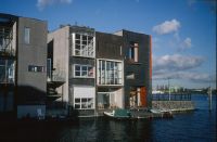
Title (German)
Amsterdam, Borneo-Eiland, Reihenhäuser
Caption
Photographer keyword: new building
Caption (German)
Schlagwort Bestandsbildner: Neubau
Record Name
Dia_287-31236

Title (German)
Amsterdam, Borneo-Eiland, Reihenhäuser
Caption
Photographer keyword: new building
Caption (German)
Schlagwort Bestandsbildner: Neubau
Record Name
Dia_287-31237

Title (German)
Amsterdam, Borneo-Eiland, Reihenhäuser
Caption
Photographer keyword: new building
Caption (German)
Schlagwort Bestandsbildner: Neubau
Record Name
Dia_287-31238

Title (German)
Amsterdam, Borneo-Eiland, Reihenhäuser
Caption
Photographer keyword: new building
Caption (German)
Schlagwort Bestandsbildner: Neubau
Record Name
Dia_287-31239

Title (German)
Amsterdam, Borneo-Eiland, Reihenhäuser
Caption
Photographer keyword: new building
Caption (German)
Schlagwort Bestandsbildner: Neubau
Record Name
Dia_287-31240

Title (German)
Amsterdam, Genzenveld
Caption
Photographer keyword: new building
Caption (German)
Schlagwort Bestandsbildner: Neubau
Record Name
Dia_287-31242

Title (German)
Amsterdam, Genzenveld
Caption
Photographer keyword: new building
Caption (German)
Schlagwort Bestandsbildner: Neubau
Record Name
Dia_287-31243

Title (German)
Amsterdam, Genzenveld
Caption
Photographer keyword: new building
Caption (German)
Schlagwort Bestandsbildner: Neubau
Record Name
Dia_287-31244

Title (German)
Amsterdam, Genzenveld
Caption
Photographer keyword: new building
Caption (German)
Schlagwort Bestandsbildner: Neubau
Record Name
Dia_287-31245

Title (German)
Amsterdam, Genzenveld
Caption
Photographer keyword: new building
Caption (German)
Schlagwort Bestandsbildner: Neubau
Record Name
Dia_287-31246

Title (German)
Amsterdam, Genzenveld, Hochhaus
Caption
Photographer keyword: new building
Caption (German)
Schlagwort Bestandsbildner: Neubau
Record Name
Dia_287-31247

Title (German)
Amsterdam, Genzenveld, Hochhaus aus Lambertus Zijlplein
Caption
Photographer keyword: new building
Caption (German)
Schlagwort Bestandsbildner: Neubau
Record Name
Dia_287-31248

Title (German)
Amsterdam, Genzenveld, Hochhaus aus Lambertus Zijlplein
Caption
Photographer keyword: new building
Caption (German)
Schlagwort Bestandsbildner: Neubau
Record Name
Dia_287-31249

Title (German)
Amsterdam, Genzenveld, Strachestraat
Caption
Photographer keyword: new building
Caption (German)
Schlagwort Bestandsbildner: Neubau
Record Name
Dia_287-31250

Title (German)
Amsterdam, Herengracht, 20 / 30 Jahre
Caption
Photographer keyword: old and new
Caption (German)
Schlagwort Bestandsbildner: alt und neu
Record Name
Dia_287-31251

Title (German)
Amsterdam, Java-Eiland, Jo Coenen
Caption
Photographer keyword: new building
Caption (German)
Schlagwort Bestandsbildner: Neubau
Record Name
Dia_287-31252

Title (German)
Amsterdam, Java-Eiland, Jo Coenen
Caption
Photographer keyword: new building
Caption (German)
Schlagwort Bestandsbildner: Neubau
Record Name
Dia_287-31253

Title (German)
Amsterdam, Java-Eiland, Jo Coenen
Caption
Photographer keyword: new building
Caption (German)
Schlagwort Bestandsbildner: Neubau
Record Name
Dia_287-31254

Title (German)
Amsterdam, Java-Eiland auf Roger Dieners Bloch
Caption
Photographer keyword: new building
Caption (German)
Schlagwort Bestandsbildner: Neubau
Record Name
Dia_287-31255

Title (German)
Amsterdam, Java-Eiland, Gracht
Caption
Photographer keyword: new building
Caption (German)
Schlagwort Bestandsbildner: Neubau
Record Name
Dia_287-31256
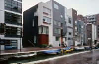
Title (German)
Amsterdam, Java-Eiland, Gracht
Caption
Photographer keyword: new building
Caption (German)
Schlagwort Bestandsbildner: Neubau
Record Name
Dia_287-31257

Title (German)
Amsterdam, Java-Eiland, Gracht
Caption
Photographer keyword: new building
Caption (German)
Schlagwort Bestandsbildner: Neubau
Record Name
Dia_287-31258

Title (German)
Amsterdam, Java-Eiland, H. Kollhoff
Caption
Photographer keyword: new building
Caption (German)
Schlagwort Bestandsbildner: Neubau
Record Name
Dia_287-31259

Title (German)
Amsterdam, Java-Eiland, Haus Kollhoff
Caption
Photographer keyword: new building
Caption (German)
Schlagwort Bestandsbildner: Neubau
Record Name
Dia_287-31260

Title (German)
Amsterdam, Java-Eiland, Haus Kollhoff
Caption
Photographer keyword: new building
Caption (German)
Schlagwort Bestandsbildner: Neubau
Record Name
Dia_287-31261

Title (German)
Amsterdam, Java-Eiland, Haus Kollhoff
Caption
Photographer keyword: new building
Caption (German)
Schlagwort Bestandsbildner: Neubau
Record Name
Dia_287-31262

Title (German)
Amsterdam, Java-Eiland, Haus Kollhoff, Eingang
Caption
Photographer keyword: new building
Caption (German)
Schlagwort Bestandsbildner: Neubau
Record Name
Dia_287-31263

Title (German)
Amsterdam, Java-Eiland, Nordseite
Caption
Photographer keyword: new building
Caption (German)
Schlagwort Bestandsbildner: Neubau
Record Name
Dia_287-31264

Title (German)
Amsterdam, Java-Eiland, Südseite
Caption
Photographer keyword: new building
Caption (German)
Schlagwort Bestandsbildner: Neubau
Record Name
Dia_287-31265

Title (German)
Amsterdam, Kerkstraat
Caption
Photographer keyword: old and new
Caption (German)
Schlagwort Bestandsbildner: alt und neu
Record Name
Dia_287-31266

Title (German)
Amsterdam, Kerkstraat 204, Architekt Soeters
Caption
Photographer keyword: old and new
Caption (German)
Schlagwort Bestandsbildner: alt und neu
Record Name
Dia_287-31267

Title (German)
Amsterdam, Kerkstraat 204, Architekt Soeters
Caption
Photographer keyword: old and new
Caption (German)
Schlagwort Bestandsbildner: alt und neu
Record Name
Dia_287-31268

Title (German)
Amsterdam, Kerkstraat 204, Architekt Soeters
Caption
Photographer keyword: old and new
Caption (German)
Schlagwort Bestandsbildner: alt und neu
Record Name
Dia_287-31269
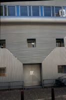
Title (German)
Amsterdam, Kerkstraat 204, Architekt Soeters
Caption
Photographer keyword: old and new
Caption (German)
Schlagwort Bestandsbildner: alt und neu
Record Name
Dia_287-31270

Title (German)
Amsterdam, KNSM-Eiland
Caption
Photographer keyword: new building
Caption (German)
Schlagwort Bestandsbildner: Neubau
Record Name
Dia_287-31271

Title (German)
Amsterdam, KNSM-Eiland, Jo Coenen
Caption
Photographer keyword: new building
Caption (German)
Schlagwort Bestandsbildner: Neubau
Record Name
Dia_287-31272

Title (German)
Amsterdam, KNSM-Eiland, Roger Diener
Caption
Photographer keyword: new building
Caption (German)
Schlagwort Bestandsbildner: Neubau
Record Name
Dia_287-31273

Title (German)
Amsterdam, KNSM-Eiland, ehemalige Kantine
Caption
Photographer keyword: old and new
Caption (German)
Schlagwort Bestandsbildner: alt und neu
Record Name
Dia_287-31274

Title (German)
Amsterdam, KNSM-Eiland mit Kollhoff
Caption
Photographer keyword: new building
Caption (German)
Schlagwort Bestandsbildner: Neubau
Record Name
Dia_287-31275

Title (German)
Amsterdam, KNSM, Piraeusplein Haus Kollhoff
Caption
Photographer keyword: new building
Caption (German)
Schlagwort Bestandsbildner: Neubau
Record Name
Dia_287-31276

Title (German)
Amsterdam, KNSM-Eiland, Piraeusplein von Haus Kollhoff
Caption
Photographer keyword: new building
Caption (German)
Schlagwort Bestandsbildner: Neubau
Record Name
Dia_287-31277

Title (German)
Amsterdam, Nieuweziids-Vorburgwal
Caption
Photographer keyword: old and new
Caption (German)
Schlagwort Bestandsbildner: alt und neu
Record Name
Dia_287-31278

Title (German)
Amsterdam, Nieuweziids-Vorburgwal
Caption
Photographer keyword: old and new
Caption (German)
Schlagwort Bestandsbildner: alt und neu
Record Name
Dia_287-31279

Title (German)
Amsterdam, Nieuweziids-Vorburgwal
Caption
Photographer keyword: old and new
Caption (German)
Schlagwort Bestandsbildner: alt und neu
Record Name
Dia_287-31280

Title (German)
Amsterdam, Dasseerdersgracht
Caption
Photographer keyword: old and new
Caption (German)
Schlagwort Bestandsbildner: alt und neu
Record Name
Dia_287-31281

Title (German)
Amsterdam, Oostoefen, Neubaugebiet
Caption
Photographer keyword: new building
Caption (German)
Schlagwort Bestandsbildner: Neubau
Record Name
Dia_287-31282

Title (German)
Amsterdam, Oostoefen, Neubaugebiet
Caption
Photographer keyword: new building
Caption (German)
Schlagwort Bestandsbildner: Neubau
Record Name
Dia_287-31283

Title (German)
Amsterdam, Oostoefer Hochhaus
Caption
Photographer keyword: new building
Caption (German)
Schlagwort Bestandsbildner: Neubau
Record Name
Dia_287-31284

Title (German)
Amsterdam, Prinseneiland
Caption
Photographer keyword: old and new
Caption (German)
Schlagwort Bestandsbildner: alt und neu
Record Name
Dia_287-31285

Title (German)
Amsterdam, Prinsengracht
Caption
Photographer keyword: new building
Caption (German)
Schlagwort Bestandsbildner: Neubau
Record Name
Dia_287-31286

Title (German)
Amsterdam, Prinsengracht
Caption
Photographer keyword: new building
Caption (German)
Schlagwort Bestandsbildner: Neubau
Record Name
Dia_287-31287

Title (German)
Amsterdam, Singelgracht, Casina
Caption
Photographer keyword: new building
Caption (German)
Schlagwort Bestandsbildner: Neubau
Record Name
Dia_287-31288

Title (German)
Amsterdam, Singelgracht, Casina
Caption
Photographer keyword: new building
Caption (German)
Schlagwort Bestandsbildner: Neubau
Record Name
Dia_287-31289

Title (German)
Amsterdam, Slootermerlaan
Caption
Photographer keyword: new building
Caption (German)
Schlagwort Bestandsbildner: Neubau
Record Name
Dia_287-31290

Title (German)
Amsterdam, Slootermeer
Caption
Photographer keyword: new building
Caption (German)
Schlagwort Bestandsbildner: Neubau
Record Name
Dia_287-31291

Title (German)
Amsterdam, Slootermer, Burgermeester Cramer Gracht
Caption
Photographer keyword: new building
Caption (German)
Schlagwort Bestandsbildner: Neubau
Record Name
Dia_287-31292

Title (German)
Amsterdam, A. d. Slootermeerlaan, Rob Krier
Caption
Photographer keyword: new building
Caption (German)
Schlagwort Bestandsbildner: Neubau
Record Name
Dia_287-31293

Title (German)
Amsterdam, A. d. Slootermeerlaan, Rob Krier
Caption
Photographer keyword: new building
Caption (German)
Schlagwort Bestandsbildner: Neubau
Record Name
Dia_287-31294

Title (German)
Amsterdam, Slootermeer, Rob Krier
Caption
Photographer keyword: new building
Caption (German)
Schlagwort Bestandsbildner: Neubau
Record Name
Dia_287-31295

Title (German)
Amsterdam, Slootermeer, Rob Krier
Caption
Photographer keyword: new building
Caption (German)
Schlagwort Bestandsbildner: Neubau
Record Name
Dia_287-31296

Title (German)
Amsterdam, Slooterpark
Caption
Photographer keyword: new building
Caption (German)
Schlagwort Bestandsbildner: Neubau
Record Name
Dia_287-31297

Title (German)
Amsterdam, Sporenburg
Caption
Photographer keyword: new building
Caption (German)
Schlagwort Bestandsbildner: Neubau
Record Name
Dia_287-31298

Title (German)
Amsterdam, Sporenburg
Caption
Photographer keyword: new building
Caption (German)
Schlagwort Bestandsbildner: Neubau
Record Name
Dia_287-31299

Title (German)
Amsterdam, Sporenburg, Balena
Caption
Photographer keyword: new building
Caption (German)
Schlagwort Bestandsbildner: Neubau
Record Name
Dia_287-31300

Title (German)
Amsterdam, Sporenburg, La Balena
Caption
Photographer keyword: new building
Caption (German)
Schlagwort Bestandsbildner: Neubau
Record Name
Dia_287-31301

Title (German)
Amsterdam, Sporenburg, Garagen im Reihenhaus
Caption
Photographer keyword: new building
Caption (German)
Schlagwort Bestandsbildner: Neubau
Record Name
Dia_287-31302

Title (German)
Amsterdam, Sporenburg, Hochhaus
Caption
Photographer keyword: new building
Caption (German)
Schlagwort Bestandsbildner: Neubau
Record Name
Dia_287-31303

Title (German)
Amsterdam, Sporenburg, Hochhaus
Caption
Photographer keyword: new building
Caption (German)
Schlagwort Bestandsbildner: Neubau
Record Name
Dia_287-31304

Title (German)
Amsterdam, Sporenburg, Hochhaus
Caption
Photographer keyword: new building
Caption (German)
Schlagwort Bestandsbildner: Neubau
Record Name
Dia_287-31305

Title (German)
Amsterdam, Sporenburg, Reihenhäuser
Caption
Photographer keyword: new building
Caption (German)
Schlagwort Bestandsbildner: Neubau
Record Name
Dia_287-31306

Title (German)
Amsterdam, Sporenburg, hochhaus und Balena
Caption
Photographer keyword: new building
Caption (German)
Schlagwort Bestandsbildner: Neubau
Record Name
Dia_287-31307

Title (German)
Amsterdam, Sporenburg, Neubauten
Caption
Photographer keyword: new building
Caption (German)
Schlagwort Bestandsbildner: Neubau
Record Name
Dia_287-31308

Title (German)
Amsterdam, Sporenburg, Reihenhäuser
Caption
Photographer keyword: new building
Caption (German)
Schlagwort Bestandsbildner: Neubau
Record Name
Dia_287-31309

Title (German)
Amsterdam, Sporenburg, Reihenhäuser
Caption
Photographer keyword: new building
Caption (German)
Schlagwort Bestandsbildner: Neubau
Record Name
Dia_287-31310

Title (German)
Amsterdam, Sporenburg, Reihenhäuser
Caption
Photographer keyword: new building
Caption (German)
Schlagwort Bestandsbildner: Neubau
Record Name
Dia_287-31311

Title (German)
Amsterdam, Sporenburg, Reihenhaus
Caption
Photographer keyword: new building
Caption (German)
Schlagwort Bestandsbildner: Neubau
Record Name
Dia_287-31312

Title (German)
Amsterdam, Stadhouderskade, Rem Kolhaas
Caption
Photographer keyword: new building
Caption (German)
Schlagwort Bestandsbildner: Neubau
Record Name
Dia_287-31313

Title (German)
Amsterdam, Stadhouderskade, Rem Kolhaas
Caption
Photographer keyword: new building
Caption (German)
Schlagwort Bestandsbildner: Neubau
Record Name
Dia_287-31314

Title (German)
Amsterdam, Stadtmuseum
Caption
Photographer keyword: old and new
Caption (German)
Schlagwort Bestandsbildner: alt und neu
Record Name
Dia_287-31315

Title (German)
Amsterdam, Stadtmuseum
Caption
Photographer keyword: old and new
Caption (German)
Schlagwort Bestandsbildner: alt und neu
Record Name
Dia_287-31316

Title (German)
Amsterdam, Amsterdam
Caption
Photographer keyword: old and new
Caption (German)
Schlagwort Bestandsbildner: alt und neu
Record Name
Dia_287-31317

Title (German)
Andelfingen, Holzbrücke über der Thur nach Erweiterung; Nutzung Verkehr
Caption
Photographer keyword: old and new
Caption (German)
Schlagwort Bestandsbildner: alt und neu
Record Name
Dia_287-31318

Title (German)
Andelfingen, Holzbrücke über der Thur nach Erweiterung; Nutzung Verkehr
Caption
Photographer keyword: old and new
Caption (German)
Schlagwort Bestandsbildner: alt und neu
Record Name
Dia_287-31319

Title (German)
Andlau, Rustikaler Neubau
Caption
Photographer keyword: new building
Caption (German)
Schlagwort Bestandsbildner: Neubau
Record Name
Dia_287-31321

Title (German)
Andlau, Tousssaints, heute Museum
Caption
Photographer keyword: old and new
Caption (German)
Schlagwort Bestandsbildner: alt und neu
Record Name
Dia_287-31322

Title (German)
Angers, Museum, Ehemalige Kirche Toussaints, heute Museum
Caption
Photographer keyword: old and new
Caption (German)
Schlagwort Bestandsbildner: alt und neu
Record Name
Dia_287-31323

Title (German)
Angers, Museum, Ehemalige Kirche Toussaints, heute Museum
Caption
Photographer keyword: old and new
Caption (German)
Schlagwort Bestandsbildner: alt und neu
Record Name
Dia_287-31324

Title (German)
Angers, Museum, Ehemalige Kirche Toussaints, heute Museum
Caption
Photographer keyword: old and new
Caption (German)
Schlagwort Bestandsbildner: alt und neu
Record Name
Dia_287-31325

Title (German)
Angers, Museum, Ehemalige Kirche Toussaints, heute Museum
Caption
Photographer keyword: old and new
Caption (German)
Schlagwort Bestandsbildner: alt und neu
Record Name
Dia_287-31326

Title (German)
Angers, Museum, Ehemalige Kirche Toussaints, heute Museum
Caption
Photographer keyword: old and new
Caption (German)
Schlagwort Bestandsbildner: alt und neu
Record Name
Dia_287-31327

Title (German)
Angers, Museum, Ehemalige Kirche Toussaints, heute Museum
Caption
Photographer keyword: old and new
Caption (German)
Schlagwort Bestandsbildner: alt und neu
Record Name
Dia_287-31328
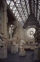
Title (German)
Angers, Museum, Ehemalige Kirche Toussaints, heute Museum
Caption
Photographer keyword: old and new
Caption (German)
Schlagwort Bestandsbildner: alt und neu
Record Name
Dia_287-31329

Title (German)
Angers, Museum, Ehemalige Kirche Toussaints, heute Museum
Caption
Photographer keyword: old and new
Caption (German)
Schlagwort Bestandsbildner: alt und neu
Record Name
Dia_287-31330