 E-PICS - ETHBIB.Bildarchiv


The images presented on this page are part of E-Pics, a service provided by the ETH-Bibliothek of ETH Zurich. You find here static medium resolution images published under the creative commons
CC-BY-SA license or with the Public Domain Mark. This means that you are free to share, copy and redistribute the material in any medium or format; that you are free to remix, transform, and build upon the material for any purpose, even commercially, under the following conditions: You must give appropriate credit, provide a link to the license, and indicate if changes were made.
- More information about E-Pics is available at https://www.e-pics.ethz.ch
- This catalog can also be accessed at https://ba.e-pics.ethz.ch/ . There you can download the image in a higher resolution.

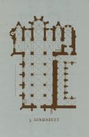
Title (German)
Halberstadt, Dom, St. Stephan, Dom
Caption
Keyword photographer: ground plan. Title rider: Halberstadt; Cathedral, St. Stephen
Caption (German)
Schlagwort Bestandsbildner: Grundriss. Titel Reiter: Halberstadt; Dom, St. Stephan
Record Name
Dia_287-24793

Title (German)
Halberstadt, Dom, St. Stephan, Dom
Caption
Keyword photographer: ground plan. Title rider: Halberstadt; Cathedral, St. Stephen
Caption (German)
Schlagwort Bestandsbildner: Grundriss. Titel Reiter: Halberstadt; Dom, St. Stephan
Record Name
Dia_287-24794

Title (German)
Halberstadt, Dom, St. Stephan, Dom
Caption
Keyword photographer: ground plan. Title rider: Halberstadt; Cathedral, St. Stephen
Caption (German)
Schlagwort Bestandsbildner: Grundriss. Titel Reiter: Halberstadt; Dom, St. Stephan
Record Name
Dia_287-24795

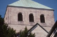
Title (German)
Halberstadt, Dom, St. Stephan, Westtürme von Osten
Caption
Title rider: Halberstadt; Cathedral, St. Stephen
Caption (German)
Titel Reiter: Halberstadt; Dom, St. Stephan
Record Name
Dia_287-24796

Title (German)
Halberstadt, Dom, St. Stephan, Südlicher Querhausgiebel
Caption
Title rider: Halberstadt; Cathedral, St. Stephen
Caption (German)
Titel Reiter: Halberstadt; Dom, St. Stephan
Record Name
Dia_287-24797

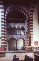
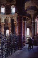
Title (German)
Halberstadt, Dom, St. Stephan, Lettner
Caption
Title rider: Halberstadt; Cathedral, St. Stephen
Caption (German)
Titel Reiter: Halberstadt; Dom, St. Stephan
Record Name
Dia_287-24798

Title (German)
Halberstadt, Liebfrauenkirche, Liebfrauen, voll. A. 1146
Caption
Keyword photographer: ground plan. Title rider: Halberstadt; Liebfrauen church
Caption (German)
Schlagwort Bestandsbildner: Grundriss. Titel Reiter: Halberstadt; Liebfrauenkirche
Record Name
Dia_287-24799

Title (German)
Halberstadt, Liebfrauenkirche, Klosterkirche Liebfrauen, a. 1135 - 1146
Caption
Keyword photographer: ground plan. Title rider: Halberstadt; Liebfrauen church
Caption (German)
Schlagwort Bestandsbildner: Grundriss. Titel Reiter: Halberstadt; Liebfrauenkirche
Record Name
Dia_287-24800

Title (German)
Halberstadt, Liebfrauenkirche, 1. H. saec. 12
Caption
Keyword photographer: ground plan. Title rider: Halberstadt; Liebfrauen church
Caption (German)
Schlagwort Bestandsbildner: Grundriss. Titel Reiter: Halberstadt; Liebfrauenkirche
Record Name
Dia_287-24801

Title (German)
Halberstadt, Liebfrauenkirche Chor
Caption
Title tab: Halberstadt; Church of Our Lady
Caption (German)
Titel Reiter: Halberstadt; Liebfrauenkirche
Record Name
Dia_287-24802

Title (German)
Halberstadt, Liebfrauenkirche Chor
Caption
Title tab: Halberstadt; Church of Our Lady
Caption (German)
Titel Reiter: Halberstadt; Liebfrauenkirche
Record Name
Dia_287-24803

Title (German)
Halberstadt, Liebfrauenkirche Chor
Caption
Title tab: Halberstadt; Church of Our Lady
Caption (German)
Titel Reiter: Halberstadt; Liebfrauenkirche
Record Name
Dia_287-24804

Title (German)
Halberstadt, Liebfrauenkirche Chor
Caption
Title tab: Halberstadt; Church of Our Lady
Caption (German)
Titel Reiter: Halberstadt; Liebfrauenkirche
Record Name
Dia_287-24805

Title (German)
Halle, Marktkirche
Caption
Title rider: Hall
Caption (German)
Titel Reiter: Halle
Record Name
Dia_287-24806

Title (German)
Halle, Marktkirche, Mittelschiffgewölbe
Caption
Title rider: Hall
Caption (German)
Titel Reiter: Halle
Record Name
Dia_287-24807

Title (German)
Halle, Marktkirche, Gewölbe
Caption
Title rider: Hall
Caption (German)
Titel Reiter: Halle
Record Name
Dia_287-24808

Title (German)
Halle, Marktkirche, Seitenschiffgewölbe
Caption
Title rider: Hall
Caption (German)
Titel Reiter: Halle
Record Name
Dia_287-24809

Title (German)
Halle, Halle a. d. Saale, Marktkirche, Gewölbe
Caption
Title rider: Hall
Caption (German)
Titel Reiter: Halle
Record Name
Dia_287-24810

Title (German)
Hallstadt
Caption
Keyword photographer: floor plan. Title rider: Hallstadt
Caption (German)
Schlagwort Bestandsbildner: Grundriss. Titel Reiter: Hallstadt
Record Name
Dia_287-24811

Title (German)
Halmstad, Halmestad
Caption
Keyword photographer: Floor plan. Title rider: Halmestad
Caption (German)
Schlagwort Bestandsbildner: Grundriss. Titel Reiter: Halmestad
Record Name
Dia_287-24812

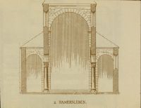
Title (German)
Hamersleben, Augustinerkirche, a. 1112ff
Caption
Keyword photographer: floor plan. Title rider: Hamersleben
Caption (German)
Schlagwort Bestandsbildner: Grundriss. Titel Reiter: Hamersleben
Record Name
Dia_287-24813
Title (German)
Hamersleben, A. 1112ff
Caption
Keyword photographer: floor plan. Title rider: Hamersleben
Caption (German)
Schlagwort Bestandsbildner: Grundriss. Titel Reiter: Hamersleben
Record Name
Dia_287-24814

Title (German)
Hamersleben, A. 1112ff
Caption
Keyword photographer: floor plan. Title rider: Hamersleben
Caption (German)
Schlagwort Bestandsbildner: Grundriss. Titel Reiter: Hamersleben
Record Name
Dia_287-24815

Title (German)
Haro, Haro (Logroño), Sto. Tomás, Chorgrundriss
Caption
Keyword photographer: Floor plan. Title rider: Haro
Caption (German)
Schlagwort Bestandsbildner: Grundriss. Titel Reiter: Haro
Record Name
Dia_287-24816

Title (German)
Hartberg, Karner, saec. 12
Caption
Keyword photographer: floor plan. Title rider: Hartberg
Caption (German)
Schlagwort Bestandsbildner: Grundriss. Titel Reiter: Hartberg
Record Name
Dia_287-24817

Title (German)
Haslach, Pfarrkirche, Langhaus
Caption
Title rider: Haslach
Caption (German)
Titel Reiter: Haslach
Record Name
Dia_287-24818

Title (German)
Hauterive
Caption
Keyword Photographer: Floor plan. Title tab: Hauterive
Caption (German)
Schlagwort Bestandsbildner: Grundriss. Titel Reiter: Hauterive
Record Name
Dia_287-24819

Title (German)
Hauterive
Caption
Keyword Photographer: Floor plan. Title tab: Hauterive
Caption (German)
Schlagwort Bestandsbildner: Grundriss. Titel Reiter: Hauterive
Record Name
Dia_287-24820

Title (German)
Hauterive, Saec. 12
Caption
Keyword Photographer: Floor plan. Title tab: Hauterive
Caption (German)
Schlagwort Bestandsbildner: Grundriss. Titel Reiter: Hauterive
Record Name
Dia_287-24821

Title (German)
Hecklingen, E. saec. 12
Caption
Keyword photographer: floor plan. Title rider: Hecklingen
Caption (German)
Schlagwort Bestandsbildner: Grundriss. Titel Reiter: Hecklingen
Record Name
Dia_287-24822

Title (German)
Heiligenkreuz, Heiligkreuz
Caption
Keyword photographer: floor plan. Title rider: Heiligenkreuz
Caption (German)
Schlagwort Bestandsbildner: Grundriss. Titel Reiter: Heiligenkreuz
Record Name
Dia_287-24823

Title (German)
Heiligenkreuz, Heiligkreuz
Caption
Keyword photographer: floor plan. Title rider: Heiligenkreuz
Caption (German)
Schlagwort Bestandsbildner: Grundriss. Titel Reiter: Heiligenkreuz
Record Name
Dia_287-24824

Title (German)
Heiligenkreuz, Heiligkreuz
Caption
Keyword photographer: floor plan. Title rider: Heiligenkreuz
Caption (German)
Schlagwort Bestandsbildner: Grundriss. Titel Reiter: Heiligenkreuz
Record Name
Dia_287-24825

Title (German)
Heiligenkreuz, Gesamtanlage
Caption
Title rider: Heiligenkreuz
Caption (German)
Titel Reiter: Heiligenkreuz
Record Name
Dia_287-24826

Title (German)
Heiligenkreuz, Zisterzienserkirche
Caption
Title rider: Heiligenkreuz
Caption (German)
Titel Reiter: Heiligenkreuz
Record Name
Dia_287-24827

Title (German)
Heiligenkreuz, Zisterzienserkirche
Caption
Title rider: Heiligenkreuz
Caption (German)
Titel Reiter: Heiligenkreuz
Record Name
Dia_287-24828

Title (German)
Heiligenkreuz, Zisterzienserkirche
Caption
Title rider: Heiligenkreuz
Caption (German)
Titel Reiter: Heiligenkreuz
Record Name
Dia_287-24830

Title (German)
Heiligenkreuz, Hallenchor der Zisterzienserkirche, innen
Caption
Title rider: Heiligenkreuz; inside
Caption (German)
Titel Reiter: Heiligenkreuz; innen
Record Name
Dia_287-24832

Title (German)
Heiligenkreuz, Hallenchor der Zisterzienserkirche, innen
Caption
Title rider: Heiligenkreuz; inside
Caption (German)
Titel Reiter: Heiligenkreuz; innen
Record Name
Dia_287-24833

Title (German)
Heiligenkreuz, Chor, innen
Caption
Title rider: Heiligenkreuz; inside
Caption (German)
Titel Reiter: Heiligenkreuz; innen
Record Name
Dia_287-24834

Title (German)
Heiligenkreuz, Zisterzienserkirche, innen
Caption
Title rider: Heiligenkreuz; inside
Caption (German)
Titel Reiter: Heiligenkreuz; innen
Record Name
Dia_287-24835

Title (German)
Heiligenkreuz, Zisterzienserkirche, innen
Caption
Title rider: Heiligenkreuz; inside
Caption (German)
Titel Reiter: Heiligenkreuz; innen
Record Name
Dia_287-24836

Title (German)
Heiligenkreuz, Zisterzienserkirche, innen
Caption
Title rider: Heiligenkreuz; inside
Caption (German)
Titel Reiter: Heiligenkreuz; innen
Record Name
Dia_287-24837

Title (German)
Heiligenkreuz, Zisterzienserkirche, innen
Caption
Title rider: Heiligenkreuz; inside
Caption (German)
Titel Reiter: Heiligenkreuz; innen
Record Name
Dia_287-24838

Title (German)
Heiligenkreuz, Zisterzienserkirche, innen
Caption
Title rider: Heiligenkreuz; inside
Caption (German)
Titel Reiter: Heiligenkreuz; innen
Record Name
Dia_287-24839

Title (German)
Heiligenkreuz, Zisterzienserkirche, innen
Caption
Title rider: Heiligenkreuz; inside
Caption (German)
Titel Reiter: Heiligenkreuz; innen
Record Name
Dia_287-24840

Title (German)
Heiligenkreuz, Zisterzienserkirche, innen
Caption
Title rider: Heiligenkreuz; inside
Caption (German)
Titel Reiter: Heiligenkreuz; innen
Record Name
Dia_287-24841

Title (German)
Heiligenkreuz, Zisterzienserkirche, innen
Caption
Title rider: Heiligenkreuz; inside
Caption (German)
Titel Reiter: Heiligenkreuz; innen
Record Name
Dia_287-24842

Title (German)
Heiligenkreuz, Zisterzienserkirche, innen
Caption
Title rider: Heiligenkreuz; inside
Caption (German)
Titel Reiter: Heiligenkreuz; innen
Record Name
Dia_287-24843

Title (German)
Heiligenkreuz, Zisterzienserkirche, Langhaus, innen
Caption
Title rider: Heiligenkreuz; inside
Caption (German)
Titel Reiter: Heiligenkreuz; innen
Record Name
Dia_287-24844

Title (German)
Heiligenkreuz, Zisterzienserkirche, innen
Caption
Title rider: Heiligenkreuz; inside
Caption (German)
Titel Reiter: Heiligenkreuz; innen
Record Name
Dia_287-24845

Title (German)
Heiligenkreuz, Zisterzienserkirche, innen
Caption
Title rider: Heiligenkreuz; inside
Caption (German)
Titel Reiter: Heiligenkreuz; innen
Record Name
Dia_287-24846

Title (German)
Heiligenkreuz, Zisterzienserkirche, innen
Caption
Title rider: Heiligenkreuz; inside
Caption (German)
Titel Reiter: Heiligenkreuz; innen
Record Name
Dia_287-24847

Title (German)
Heiligenkreuz, Zisterzienserkirche, innen
Caption
Title rider: Heiligenkreuz; inside
Caption (German)
Titel Reiter: Heiligenkreuz; innen
Record Name
Dia_287-24848

Title (German)
Heiligenkreuz, Zisterzienserkirche, innen
Caption
Title rider: Heiligenkreuz; inside
Caption (German)
Titel Reiter: Heiligenkreuz; innen
Record Name
Dia_287-24849

Title (German)
Heiligenkreuz, Zisterzienserkirche, innen
Caption
Title rider: Heiligenkreuz; inside
Caption (German)
Titel Reiter: Heiligenkreuz; innen
Record Name
Dia_287-24851

Title (German)
Heiligenkreuz, Zisterzienserkirche, innen
Caption
Title rider: Heiligenkreuz; inside
Caption (German)
Titel Reiter: Heiligenkreuz; innen
Record Name
Dia_287-24852

Title (German)
Heiligenkreuz, Kreuzgang
Caption
Title tab: Heiligenkreuz; cloister
Caption (German)
Titel Reiter: Heiligenkreuz; Kreuzgang
Record Name
Dia_287-24853

Title (German)
Heiligenkreuz, Kreuzgang
Caption
Title tab: Heiligenkreuz; cloister
Caption (German)
Titel Reiter: Heiligenkreuz; Kreuzgang
Record Name
Dia_287-24854

Title (German)
Heiligenkreuz, Kreuzgang
Caption
Title tab: Heiligenkreuz; cloister
Caption (German)
Titel Reiter: Heiligenkreuz; Kreuzgang
Record Name
Dia_287-24855

Title (German)
Heiligenkreuz, Zisterzienserkirche, Kreuzgang
Caption
Title tab: Heiligenkreuz; cloister
Caption (German)
Titel Reiter: Heiligenkreuz; Kreuzgang
Record Name
Dia_287-24856

Title (German)
Heiligenkreuz, Zisterzienserkirche, Kreuzgang
Caption
Title tab: Heiligenkreuz; cloister
Caption (German)
Titel Reiter: Heiligenkreuz; Kreuzgang
Record Name
Dia_287-24857

Title (German)
Heiligenkreuz, Zisterzienserkirche, Kreuzgang
Caption
Title tab: Heiligenkreuz; cloister
Caption (German)
Titel Reiter: Heiligenkreuz; Kreuzgang
Record Name
Dia_287-24858

Title (German)
Heiligenkreuz, Zisterzienserkloster
Caption
Title tab: Heiligenkreuz; cloister
Caption (German)
Titel Reiter: Heiligenkreuz; Kreuzgang
Record Name
Dia_287-24859

Title (German)
Alzey, Heimersheim, Pfarrkirche, 2. Viertel saec. 13
Caption
Keyword photographer: floor plan. Title rider: Heimersheim
Caption (German)
Schlagwort Bestandsbildner: Grundriss. Titel Reiter: Heimersheim
Record Name
Dia_287-24860

Title (German)
Alzey, Heimersheim, E. saec. 12
Caption
Keyword photographer: floor plan. Title rider: Heimersheim
Caption (German)
Schlagwort Bestandsbildner: Grundriss. Titel Reiter: Heimersheim
Record Name
Dia_287-24861

Title (German)
Heiningen
Caption
Keyword photographer: floor plan. Title rider: Heiningen
Caption (German)
Schlagwort Bestandsbildner: Grundriss. Titel Reiter: Heiningen
Record Name
Dia_287-24862

Title (German)
Heiningen
Caption
Keyword photographer: floor plan. Title rider: Heiningen
Caption (German)
Schlagwort Bestandsbildner: Grundriss. Titel Reiter: Heiningen
Record Name
Dia_287-24863

Title (German)
Heiningen
Caption
Keyword photographer: floor plan. Title rider: Heiningen
Caption (German)
Schlagwort Bestandsbildner: Grundriss. Titel Reiter: Heiningen
Record Name
Dia_287-24864

Title (German)
Königswinter, Kloster Heisterbach
Caption
Keyword photographer: floor plan. Title rider: Heisterbach
Caption (German)
Schlagwort Bestandsbildner: Grundriss. Titel Reiter: Heisterbach
Record Name
Dia_287-24865

Title (German)
Königswinter, Kloster Heisterbach
Caption
Keyword photographer: floor plan. Title rider: Heisterbach
Caption (German)
Schlagwort Bestandsbildner: Grundriss. Titel Reiter: Heisterbach
Record Name
Dia_287-24866

Title (German)
Königswinter, Kloster Heisterbach
Caption
Keyword photographer: floor plan. Title rider: Heisterbach
Caption (German)
Schlagwort Bestandsbildner: Grundriss. Titel Reiter: Heisterbach
Record Name
Dia_287-24867

Title (German)
Königswinter, Kloster Heisterbach
Caption
Keyword photographer: floor plan. Title rider: Heisterbach
Caption (German)
Schlagwort Bestandsbildner: Grundriss. Titel Reiter: Heisterbach
Record Name
Dia_287-24868

Title (German)
Königswinter, Kloster Heisterbach
Caption
Keyword photographer: floor plan. Title rider: Heisterbach
Caption (German)
Schlagwort Bestandsbildner: Grundriss. Titel Reiter: Heisterbach
Record Name
Dia_287-24869

Title (German)
Königswinter, Kloster Heisterbach
Caption
Keyword photographer: floor plan. Title rider: Heisterbach
Caption (German)
Schlagwort Bestandsbildner: Grundriss. Titel Reiter: Heisterbach
Record Name
Dia_287-24870

Title (German)
Königswinter, Kloster Heisterbach, Ruine des Chores
Caption
Keyword photographer: floor plan. Title rider: Heisterbach
Caption (German)
Schlagwort Bestandsbildner: Grundriss. Titel Reiter: Heisterbach
Record Name
Dia_287-24871

Title (German)
Königswinter, Kloster Heisterbach, Chorruine, ca. 1930
Caption
Title rider: Heisterbach
Caption (German)
Titel Reiter: Heisterbach
Record Name
Dia_287-24872

Title (German)
Königswinter, Kloster Heisterbach, Chorumgang nach Nordosten, ca. 1925
Caption
Title rider: Heisterbach
Caption (German)
Titel Reiter: Heisterbach
Record Name
Dia_287-24873

Title (German)
Helmstedt, Helmstädt, Lindgeri-Kapelle
Caption
Keyword photographer: Floor plan. Title rider: Helmstädt
Caption (German)
Schlagwort Bestandsbildner: Grundriss. Titel Reiter: Helmstädt
Record Name
Dia_287-24874

Title (German)
Helmstedt, Helmstädt, Lundgeri-Kapelle
Caption
Keyword photographer: Floor plan. Title rider: Helmstädt
Caption (German)
Schlagwort Bestandsbildner: Grundriss. Titel Reiter: Helmstädt
Record Name
Dia_287-24875

Title (German)
Helsingborg, Helsingborg
Caption
Keyword photographer: floor plan. Title rider: Helsingborg
Caption (German)
Schlagwort Bestandsbildner: Grundriss. Titel Reiter: Helsingborg
Record Name
Dia_287-24876

Title (German)
Hereford, Kathedrale, rom. Teil saec. 12
Caption
Keyword photographer: floor plan. Title rider: Hereford
Caption (German)
Schlagwort Bestandsbildner: Grundriss. Titel Reiter: Hereford
Record Name
Dia_287-24877

Title (German)
Herford
Caption
Keyword photographer: floor plan. Title rider: Herford
Caption (German)
Schlagwort Bestandsbildner: Grundriss. Titel Reiter: Herford
Record Name
Dia_287-24878

Title (German)
Hermès, Saec. 11 (?)
Caption
Keyword photographer: floor plan. Title rider: Hermès
Caption (German)
Schlagwort Bestandsbildner: Grundriss. Titel Reiter: Hermès
Record Name
Dia_287-24879

Title (German)
Bad Hersfeld, Hersfeld, Benediktinerkirche, saec. 9. / M. 12
Caption
Keyword photographer: floor plan. Title rider: Hersfeld
Caption (German)
Schlagwort Bestandsbildner: Grundriss. Titel Reiter: Hersfeld
Record Name
Dia_287-24880

Title (German)
Bad Hersfeld, Hersfeld, Benediktinerkirche, a. 1040ff
Caption
Keyword photographer: floor plan. Title rider: Hersfeld
Caption (German)
Schlagwort Bestandsbildner: Grundriss. Titel Reiter: Hersfeld
Record Name
Dia_287-24881

Title (German)
Bad Hersfeld, Hersfeld, Benediktinerkirche, saec. 9
Caption
Keyword photographer: floor plan. Title rider: Hersfeld
Caption (German)
Schlagwort Bestandsbildner: Grundriss. Titel Reiter: Hersfeld
Record Name
Dia_287-24882

Title (German)
Bad Hersfeld, Hersfeld, a. 1040ff
Caption
Keyword photographer: floor plan. Title rider: Hersfeld
Caption (German)
Schlagwort Bestandsbildner: Grundriss. Titel Reiter: Hersfeld
Record Name
Dia_287-24883

Title (German)
Bad Hersfeld, Hersfeld, Hessen
Caption
Title rider: Hersfeld
Caption (German)
Titel Reiter: Hersfeld
Record Name
Dia_287-24884

Title (German)
Hertogenbosch, S. Jan
Caption
Keyword photographer: floor plan. Title rider: Hertogenbosch
Caption (German)
Schlagwort Bestandsbildner: Grundriss. Titel Reiter: Hertogenbosch
Record Name
Dia_287-24885

Title (German)
Hexham
Caption
Keyword photographer: floor plan. Title rider: Hexham
Caption (German)
Schlagwort Bestandsbildner: Grundriss. Titel Reiter: Hexham
Record Name
Dia_287-24886

Title (German)
Hildesheim, Dom, Dom 1055 - 1061
Caption
Keyword photographer: floor plan. Title tab: Hildesheim; Cathedral
Caption (German)
Schlagwort Bestandsbildner: Grundriss. Titel Reiter: Hildesheim; Dom
Record Name
Dia_287-24887

Title (German)
Hildesheim, St. Andreas
Caption
Keyword photographer: floor plan. Title rider: Hildesheim; St. Andrew
Caption (German)
Schlagwort Bestandsbildner: Grundriss. Titel Reiter: Hildesheim; St. Andreas
Record Name
Dia_287-24888

Title (German)
Hildesheim, St. Godehard, Klosterkirche, St. Godehard a. 1133ff
Caption
Keyword photographer: ground plan. Title rider: Hildesheim; St. Godehard
Caption (German)
Schlagwort Bestandsbildner: Grundriss. Titel Reiter: Hildesheim; St. Godehard
Record Name
Dia_287-24889

Title (German)
Hildesheim, St. Godehard, A. 1133ff
Caption
Keyword photographer: ground plan. Title rider: Hildesheim; St. Godehard
Caption (German)
Schlagwort Bestandsbildner: Grundriss. Titel Reiter: Hildesheim; St. Godehard
Record Name
Dia_287-24890

Title (German)
Hildesheim, St. Godehard, Voll. A. 1172
Caption
Keyword photographer: ground plan. Title rider: Hildesheim; St. Godehard
Caption (German)
Schlagwort Bestandsbildner: Grundriss. Titel Reiter: Hildesheim; St. Godehard
Record Name
Dia_287-24891

Title (German)
Hildesheim, St. Godehard
Caption
Keyword photographer: ground plan. Title rider: Hildesheim; St. Godehard
Caption (German)
Schlagwort Bestandsbildner: Grundriss. Titel Reiter: Hildesheim; St. Godehard
Record Name
Dia_287-24892
Title (German)
Hildesheim, St. Godehard, Chor von aussen
Caption
Title rider: Hildesheim; St. Godehard
Caption (German)
Titel Reiter: Hildesheim; St. Godehard
Record Name
Dia_287-24893
Title (German)
Hildesheim, St. Godehard, Ansicht von Südosten
Caption
Title rider: Hildesheim; St. Godehard
Caption (German)
Titel Reiter: Hildesheim; St. Godehard
Record Name
Dia_287-24894

Title (German)
Hildesheim, St. Godehard, Chor aussen
Caption
Title rider: Hildesheim; St. Godehard
Caption (German)
Titel Reiter: Hildesheim; St. Godehard
Record Name
Dia_287-24895

Title (German)
Hildesheim, St. Godehard, Rundbogenfries, Chor
Caption
Title rider: Hildesheim; St. Godehard
Caption (German)
Titel Reiter: Hildesheim; St. Godehard
Record Name
Dia_287-24896
Title (German)
Hildesheim, St. Godehard, Rundbogenfries, Chor
Caption
Title rider: Hildesheim; St. Godehard
Caption (German)
Titel Reiter: Hildesheim; St. Godehard
Record Name
Dia_287-24897

Title (German)
Hildesheim, St. Godehard, Chor
Caption
Title rider: Hildesheim; St. Godehard
Caption (German)
Titel Reiter: Hildesheim; St. Godehard
Record Name
Dia_287-24898

Title (German)
Hildesheim, St. Godehard, Chorumgang
Caption
Title rider: Hildesheim; St. Godehard
Caption (German)
Titel Reiter: Hildesheim; St. Godehard
Record Name
Dia_287-24899

Title (German)
Hildesheim, St. Godehard, Chorumgang
Caption
Title rider: Hildesheim; St. Godehard
Caption (German)
Titel Reiter: Hildesheim; St. Godehard
Record Name
Dia_287-24900

Title (German)
Hildesheim, St. Godehard, Chorumgang
Caption
Title rider: Hildesheim; St. Godehard
Caption (German)
Titel Reiter: Hildesheim; St. Godehard
Record Name
Dia_287-24901

Title (German)
Hildesheim, St. Godehard, Langhaus
Caption
Title rider: Hildesheim; St. Godehard
Caption (German)
Titel Reiter: Hildesheim; St. Godehard
Record Name
Dia_287-24902

Title (German)
Hildesheim, St. Godehard, Langhaus von Osten
Caption
Title rider: Hildesheim; St. Godehard
Caption (German)
Titel Reiter: Hildesheim; St. Godehard
Record Name
Dia_287-24903

Title (German)
Hildesheim, St. Godehard, Langhaus nach Westen
Caption
Title rider: Hildesheim; St. Godehard
Caption (German)
Titel Reiter: Hildesheim; St. Godehard
Record Name
Dia_287-24904

Title (German)
Hildesheim, St. Michael
Caption
Keyword photographer: floor plan. Title rider: Hildesheim; St. Miachel
Caption (German)
Schlagwort Bestandsbildner: Grundriss. Titel Reiter: Hildesheim; St. Miachel
Record Name
Dia_287-24905

Title (German)
Hildesheim, St. Miachel, Saec. 11
Caption
Keyword photographer: floor plan. Title rider: Hildesheim; St. Miachel
Caption (German)
Schlagwort Bestandsbildner: Grundriss. Titel Reiter: Hildesheim; St. Miachel
Record Name
Dia_287-24906

Title (German)
Hildesheim, St. Miachel, St. Michael
Caption
Keyword photographer: floor plan. Title rider: Hildesheim; St. Miachel
Caption (German)
Schlagwort Bestandsbildner: Grundriss. Titel Reiter: Hildesheim; St. Miachel
Record Name
Dia_287-24907

Title (German)
Hildesheim, St. Miachel, Saec. 11
Caption
Keyword photographer: floor plan. Title rider: Hildesheim; St. Miachel
Caption (German)
Schlagwort Bestandsbildner: Grundriss. Titel Reiter: Hildesheim; St. Miachel
Record Name
Dia_287-24908

Title (German)
Hildesheim, St. Miachel, A. 1001ff
Caption
Keyword photographer: floor plan. Title rider: Hildesheim; St. Miachel
Caption (German)
Schlagwort Bestandsbildner: Grundriss. Titel Reiter: Hildesheim; St. Miachel
Record Name
Dia_287-24909

Title (German)
Hildesheim, St. Miachel, St. Michael
Caption
Keyword photographer: floor plan. Title rider: Hildesheim; St. Miachel
Caption (German)
Schlagwort Bestandsbildner: Grundriss. Titel Reiter: Hildesheim; St. Miachel
Record Name
Dia_287-24910

Title (German)
Hildesheim, St. Miachel, Saec. 11 und 12
Caption
Keyword photographer: floor plan. Title rider: Hildesheim; St. Miachel
Caption (German)
Schlagwort Bestandsbildner: Grundriss. Titel Reiter: Hildesheim; St. Miachel
Record Name
Dia_287-24911

Title (German)
Hildesheim, St. Michael
Caption
Keyword photographer: floor plan. Title rider: Hildesheim; St. Miachel
Caption (German)
Schlagwort Bestandsbildner: Grundriss. Titel Reiter: Hildesheim; St. Miachel
Record Name
Dia_287-24912

Title (German)
Hildesheim, St. Miachel, Bernwardsbau
Caption
Keyword photographer: floor plan. Title rider: Hildesheim; St. Miachel
Caption (German)
Schlagwort Bestandsbildner: Grundriss. Titel Reiter: Hildesheim; St. Miachel
Record Name
Dia_287-24913

Title (German)
Hildesheim, St. Miachel, Umbau nach Erhebung der Bernhard-Gebeine (um 1200, vor 1220)
Caption
Keyword photographer: floor plan. Title rider: Hildesheim; St. Miachel
Caption (German)
Schlagwort Bestandsbildner: Grundriss. Titel Reiter: Hildesheim; St. Miachel
Record Name
Dia_287-24914

Title (German)
Hildesheim, St. Michaelis, Zustand von 1033
Caption
Title rider: Hildesheim; St. Miachel
Caption (German)
Titel Reiter: Hildesheim; St. Miachel
Record Name
Dia_287-24915

Title (German)
Hildesheim, St. Michaelis, Süd-Ansicht, innen
Caption
Title rider: Hildesheim; St. Miachel; inside
Caption (German)
Titel Reiter: Hildesheim; St. Michaelis; innen
Record Name
Dia_287-24916

Title (German)
Hildesheim, St. Michaelis, Südseite, innen
Caption
Title rider: Hildesheim; St. Miachel; inside
Caption (German)
Titel Reiter: Hildesheim; St. Michaelis; innen
Record Name
Dia_287-24917

Title (German)
Hildesheim, St. Michaelis, Südseite, innen
Caption
Title rider: Hildesheim; St. Miachel; inside
Caption (German)
Titel Reiter: Hildesheim; St. Michaelis; innen
Record Name
Dia_287-24918

Title (German)
Hildesheim, St. Michaelis, Ostbau, innen
Caption
Title rider: Hildesheim; St. Miachel; inside
Caption (German)
Titel Reiter: Hildesheim; St. Michaelis; innen
Record Name
Dia_287-24919

Title (German)
Hildesheim, St. Michaelis, Ostbau, innen
Caption
Title rider: Hildesheim; St. Miachel; inside
Caption (German)
Titel Reiter: Hildesheim; St. Michaelis; innen
Record Name
Dia_287-24920
Title (German)
Hildesheim, St. Michaelis, Östlicher Vierungsturm, innen
Caption
Title rider: Hildesheim; St. Miachel; inside
Caption (German)
Titel Reiter: Hildesheim; St. Michaelis; innen
Record Name
Dia_287-24921

Title (German)
Hildesheim, St. Michaelis, Westlicher Vierungsturm, innen
Caption
Title rider: Hildesheim; St. Miachel; inside
Caption (German)
Titel Reiter: Hildesheim; St. Michaelis; innen
Record Name
Dia_287-24922

Title (German)
Hildesheim, St. Michaelis, Westlicher Vierungsturm, innen
Caption
Title rider: Hildesheim; St. Miachel; inside
Caption (German)
Titel Reiter: Hildesheim; St. Michaelis; innen
Record Name
Dia_287-24923

Title (German)
Hildesheim, St. Michaelis, Westchor von aussen, innen
Caption
Title rider: Hildesheim; St. Miachel; inside
Caption (German)
Titel Reiter: Hildesheim; St. Michaelis; innen
Record Name
Dia_287-24924

Title (German)
Hildesheim, St. Michaelis, Westchor aussen, innen
Caption
Title rider: Hildesheim; St. Miachel; inside
Caption (German)
Titel Reiter: Hildesheim; St. Michaelis; innen
Record Name
Dia_287-24925

Title (German)
Hildesheim, St. Michaelis, St. Michael, innen
Caption
Title rider: Hildesheim; St. Miachel; inside
Caption (German)
Titel Reiter: Hildesheim; St. Michaelis; innen
Record Name
Dia_287-24926

Title (German)
Hildesheim, St. Michaelis, Langhaus nach Osten, innen
Caption
Title rider: Hildesheim; St. Miachel; inside
Caption (German)
Titel Reiter: Hildesheim; St. Michaelis; innen
Record Name
Dia_287-24927

Title (German)
Hildesheim, St. Michaelis, Langhaus nach Osten, innen
Caption
Title rider: Hildesheim; St. Miachel; inside
Caption (German)
Titel Reiter: Hildesheim; St. Michaelis; innen
Record Name
Dia_287-24928

Title (German)
Hildesheim, St. Michaelis, Langhaus nach Osten, innen
Caption
Title rider: Hildesheim; St. Miachel; inside
Caption (German)
Titel Reiter: Hildesheim; St. Michaelis; innen
Record Name
Dia_287-24929

Title (German)
Hildesheim, St. Michaelis, Stützenwechsel, innen
Caption
Title rider: Hildesheim; St. Miachel; inside
Caption (German)
Titel Reiter: Hildesheim; St. Michaelis; innen
Record Name
Dia_287-24930

Title (German)
Hildesheim, St. Miachel, Nordwand des östlichen Querschiffs, innen
Caption
Title rider: Hildesheim; St. Miachel; inside
Caption (German)
Titel Reiter: Hildesheim; St. Miachel; innen
Record Name
Dia_287-24931
Title (German)
Hildesheim, St. Miachel, Nordwand des östlichen Querschiffs, innen
Caption
Title rider: Hildesheim; St. Miachel; inside
Caption (German)
Titel Reiter: Hildesheim; St. Miachel; innen
Record Name
Dia_287-24932

Title (German)
Hildesheim, St. Miachel, Nördliche Mittelschiffwand, innen
Caption
Title rider: Hildesheim; St. Miachel; inside
Caption (German)
Titel Reiter: Hildesheim; St. Miachel; innen
Record Name
Dia_287-24933

Title (German)
Hildesheim, St. Miachel, Nördliche Mittelschiffwand, innen
Caption
Title rider: Hildesheim; St. Miachel; inside
Caption (German)
Titel Reiter: Hildesheim; St. Miachel; innen
Record Name
Dia_287-24934

Title (German)
Hildesheim, St. Miachel, Nördliche Mittelschiffwand, innen
Caption
Title rider: Hildesheim; St. Miachel; inside
Caption (German)
Titel Reiter: Hildesheim; St. Miachel; innen
Record Name
Dia_287-24935

Title (German)
Hildesheim, St. Michaelis, Ostchor und Vierung 1010 - 1033, innen
Caption
Title rider: Hildesheim; St. Miachel; inside
Caption (German)
Titel Reiter: Hildesheim; St. Michaelis; innen
Record Name
Dia_287-24936

Title (German)
Hildesheim, St. Michaelis, Östliche Vierung + Chor, innen
Caption
Title rider: Hildesheim; St. Miachel; inside
Caption (German)
Titel Reiter: Hildesheim; St. Michaelis; innen
Record Name
Dia_287-24937

Title (German)
Hildesheim, St. Michaelis, Östliche Vierung, innen
Caption
Title rider: Hildesheim; St. Miachel; inside
Caption (German)
Titel Reiter: Hildesheim; St. Michaelis; innen
Record Name
Dia_287-24938

Title (German)
Hildesheim, St. Michaelis, Chor, östliche Vierung, innen
Caption
Title rider: Hildesheim; St. Miachel; inside
Caption (German)
Titel Reiter: Hildesheim; St. Michaelis; innen
Record Name
Dia_287-24939

Title (German)
Hildesheim, St. Miachel, Südempore im östlichen Querschiff, 1010 - 1033, innen
Caption
Title rider: Hildesheim; St. Miachel; inside
Caption (German)
Titel Reiter: Hildesheim; St. Miachel; innen
Record Name
Dia_287-24940

Title (German)
Hildesheim, St. Miachel, Südliches Seitenschiff, innen
Caption
Title rider: Hildesheim; St. Miachel; inside
Caption (German)
Titel Reiter: Hildesheim; St. Miachel; innen
Record Name
Dia_287-24941

Title (German)
Hildesheim, St. Michaelis, Westliche Vierung, innen
Caption
Title rider: Hildesheim; St. Miachel; inside
Caption (German)
Titel Reiter: Hildesheim; St. Michaelis; innen
Record Name
Dia_287-24942

Title (German)
Hildesheim, St. Michaelis, Westliche Vierung, innen
Caption
Title rider: Hildesheim; St. Miachel; inside
Caption (German)
Titel Reiter: Hildesheim; St. Michaelis; innen
Record Name
Dia_287-24943

Title (German)
Hirsau, S. Aurelius a. 1060 - 1071
Caption
Keyword photographer: floor plan. Title rider: Hirsau
Caption (German)
Schlagwort Bestandsbildner: Grundriss. Titel Reiter: Hirsau
Record Name
Dia_287-24944

Title (German)
Hirsau, S. Aurelius a. 1060 - 1071
Caption
Keyword photographer: floor plan. Title rider: Hirsau
Caption (German)
Schlagwort Bestandsbildner: Grundriss. Titel Reiter: Hirsau
Record Name
Dia_287-24945

Title (German)
Hirsau, S. Aurelius, um 1070
Caption
Keyword photographer: floor plan. Title rider: Hirsau
Caption (German)
Schlagwort Bestandsbildner: Grundriss. Titel Reiter: Hirsau
Record Name
Dia_287-24946

Title (German)
Hirsau, S. Aurelius a. 1060 - 1071
Caption
Keyword photographer: floor plan. Title rider: Hirsau
Caption (German)
Schlagwort Bestandsbildner: Grundriss. Titel Reiter: Hirsau
Record Name
Dia_287-24947

Title (German)
Hirsau, S. Aurelius, um 1070
Caption
Keyword photographer: floor plan. Title rider: Hirsau
Caption (German)
Schlagwort Bestandsbildner: Grundriss. Titel Reiter: Hirsau
Record Name
Dia_287-24948

Title (German)
Hirsau, St. Peter und Paul
Caption
Keyword photographer: floor plan. Title rider: Hirsau
Caption (German)
Schlagwort Bestandsbildner: Grundriss. Titel Reiter: Hirsau
Record Name
Dia_287-24949

Title (German)
Hirzenhain
Caption
Keyword photographer: floor plan. Title rider: Hirzenhain
Caption (German)
Schlagwort Bestandsbildner: Grundriss. Titel Reiter: Hirzenhain
Record Name
Dia_287-24950

Title (German)
Hirzenhain
Caption
Keyword photographer: floor plan. Title rider: Hirzenhain
Caption (German)
Schlagwort Bestandsbildner: Grundriss. Titel Reiter: Hirzenhain
Record Name
Dia_287-24951
Title (German)
Hohenfurth, Hohenfurt
Caption
Keyword photographer: floor plan. Title rider: Hohenfurt
Caption (German)
Schlagwort Bestandsbildner: Grundriss. Titel Reiter: Hohenfurt
Record Name
Dia_287-24952

Title (German)
Howden
Caption
Keyword photographer: Floor plan. Title rider: Howden
Caption (German)
Schlagwort Bestandsbildner: Grundriss. Titel Reiter: Howden
Record Name
Dia_287-24953

Title (German)
Howden
Caption
Keyword photographer: Floor plan. Title rider: Howden
Caption (German)
Schlagwort Bestandsbildner: Grundriss. Titel Reiter: Howden
Record Name
Dia_287-24954

Title (German)
Howden
Caption
Keyword photographer: Floor plan. Title rider: Howden
Caption (German)
Schlagwort Bestandsbildner: Grundriss. Titel Reiter: Howden
Record Name
Dia_287-24955

Title (German)
Höxter, St. Kilian, (ehemaliger) Westchor
Caption
Title rider: Höxter
Caption (German)
Titel Reiter: Höxter
Record Name
Dia_287-24956

Title (German)
Höxter, St. Kilian, (ehemaliger) Westchor
Caption
Title rider: Höxter
Caption (German)
Titel Reiter: Höxter
Record Name
Dia_287-24957

Title (German)
Höxter, St. Kilian, (ehemaliger) Westchor
Caption
Title rider: Höxter
Caption (German)
Titel Reiter: Höxter
Record Name
Dia_287-24958

Title (German)
Burgos, Las Huelgas, Las Huelgas
Caption
Keyword photographer: Floor plan. Title rider: Las Huelgas
Caption (German)
Schlagwort Bestandsbildner: Grundriss. Titel Reiter: Las Huelgas
Record Name
Dia_287-24959

Title (German)
Huesca, Kathedrale
Caption
Keyword photographer: floor plan. Title tab: Huesca; Cathedral
Caption (German)
Schlagwort Bestandsbildner: Grundriss. Titel Reiter: Huesca; Kathedrale
Record Name
Dia_287-24960

Title (German)
Huesca, S. Pedro
Caption
Keyword photographer: floor plan. Title rider: Huesca; S. Pedro
Caption (German)
Schlagwort Bestandsbildner: Grundriss. Titel Reiter: Huesca; S. Pedro
Record Name
Dia_287-24961

Title (German)
Hullein, A. saec. 13
Caption
Keyword photographer: Floor plan. Title rider: Hullein
Caption (German)
Schlagwort Bestandsbildner: Grundriss. Titel Reiter: Hullein
Record Name
Dia_287-24962
![Huy, Huyseburg [Huysburg], Benedictine church, 1110 - 1121](thumbnails/thumb_ETHBIB.Bildarchiv_1320184.jpg)
Title (German)
Huy, Huyseburg [Huysburg], Benediktinerkirche, 1110 - 1121
Caption
Keyword photographer: ground plan. Title rider: Huyseburg [Huysburg].
Caption (German)
Schlagwort Bestandsbildner: Grundriss. Titel Reiter: Huyseburg [Huysburg]
Record Name
Dia_287-24963
![Huy, Huyseburg [Huysburg], A. 1110 - 1121](thumbnails/thumb_ETHBIB.Bildarchiv_1320185.jpg)
Title (German)
Huy, Huyseburg [Huysburg], A. 1110 - 1121
Caption
Keyword photographer: ground plan. Title rider: Huyseburg [Huysburg].
Caption (German)
Schlagwort Bestandsbildner: Grundriss. Titel Reiter: Huyseburg [Huysburg]
Record Name
Dia_287-24964

Title (German)
Iffley, Saec. 12
Caption
Keyword photographer: Floor plan. Title rider: Iffley
Caption (German)
Schlagwort Bestandsbildner: Grundriss. Titel Reiter: Iffley
Record Name
Dia_287-24965

Title (German)
Niddatal-Ilbenstadt, Prämonstratenserkirche 1123 - 1159
Caption
Keyword photographer: floor plan. Title rider: Ilbenstadt
Caption (German)
Schlagwort Bestandsbildner: Grundriss. Titel Reiter: Ilbenstadt
Record Name
Dia_287-24966

Title (German)
Niddatal-Ilbenstadt, A. 1122 - 1159
Caption
Keyword photographer: floor plan. Title rider: Ilbenstadt
Caption (German)
Schlagwort Bestandsbildner: Grundriss. Titel Reiter: Ilbenstadt
Record Name
Dia_287-24967

Title (German)
Niddatal-Ilbenstadt, A. 1123 - 1159
Caption
Keyword photographer: floor plan. Title rider: Ilbenstadt
Caption (German)
Schlagwort Bestandsbildner: Grundriss. Titel Reiter: Ilbenstadt
Record Name
Dia_287-24968

Title (German)
Ilmmünster, Saec. 12
Caption
Keyword photographer: floor plan. Title rider: Ilmünster
Caption (German)
Schlagwort Bestandsbildner: Grundriss. Titel Reiter: Ilmünster
Record Name
Dia_287-24969

Title (German)
Ilsenburg, Voll. A. 1077
Caption
Keyword photographer: floor plan. Title rider: Ilsenburg
Caption (German)
Schlagwort Bestandsbildner: Grundriss. Titel Reiter: Ilsenburg
Record Name
Dia_287-24970

Title (German)
Ingelheim, Palastkirche, saec. 10
Caption
Keyword photographer: floor plan. Title rider: Ingelheim
Caption (German)
Schlagwort Bestandsbildner: Grundriss. Titel Reiter: Ingelheim
Record Name
Dia_287-24971

Title (German)
Ingelheim, 2. H. saec. 12
Caption
Keyword photographer: floor plan. Title rider: Ingelheim
Caption (German)
Schlagwort Bestandsbildner: Grundriss. Titel Reiter: Ingelheim
Record Name
Dia_287-24972
![Ingolstadt, Ingoldstadt [Ingolstadt], Church of Our Lady](thumbnails/thumb_ETHBIB.Bildarchiv_1320194.jpg)
Title (German)
Ingoldstadt [Ingolstadt], Frauenkirche
Caption
Keyword photographer: floor plan. Title rider: Ingoldstadt [Ingolstadt].
Caption (German)
Schlagwort Bestandsbildner: Grundriss. Titel Reiter: Ingoldstadt [Ingolstadt]
Record Name
Dia_287-24973

Title (German)
Ingoldstadt [Ingolstadt], Frauenkirche
Caption
Keyword photographer: floor plan. Title rider: Ingoldstadt
Caption (German)
Schlagwort Bestandsbildner: Grundriss. Titel Reiter: Ingoldstadt
Record Name
Dia_287-24974

Title (German)
Innichen
Caption
Keyword photographer: Floor plan. Title rider: Inichen
Caption (German)
Schlagwort Bestandsbildner: Grundriss. Titel Reiter: Inichen
Record Name
Dia_287-24975

Title (German)
Innichen
Caption
Keyword photographer: Floor plan. Title rider: Inichen
Caption (German)
Schlagwort Bestandsbildner: Grundriss. Titel Reiter: Inichen
Record Name
Dia_287-24976

Title (German)
Innichen, Romanische Kirche
Caption
Title rider: Inichen
Caption (German)
Titel Reiter: Inichen
Record Name
Dia_287-24977

Title (German)
Innichen, Romanische Kirche
Caption
Title rider: Inichen
Caption (German)
Titel Reiter: Inichen
Record Name
Dia_287-24978

Title (German)
Innichen, Romanische Kirche
Caption
Title rider: Inichen
Caption (German)
Titel Reiter: Inichen
Record Name
Dia_287-24979

Title (German)
Innichen, Romanische Kirche
Caption
Title rider: Inichen
Caption (German)
Titel Reiter: Inichen
Record Name
Dia_287-24980

Title (German)
Innichen, Romanische Kirche
Caption
Title rider: Inichen
Caption (German)
Titel Reiter: Inichen
Record Name
Dia_287-24981

Title (German)
Innichen, Romanische Kirche
Caption
Title rider: Inichen
Caption (German)
Titel Reiter: Inichen
Record Name
Dia_287-24982

Title (German)
Issoire, S. Paul
Caption
Keyword photographer: floor plan. Title rider: Issoire
Caption (German)
Schlagwort Bestandsbildner: Grundriss. Titel Reiter: Issoire
Record Name
Dia_287-24983

Title (German)
Issoire, S. Paul
Caption
Keyword photographer: floor plan. Title rider: Issoire
Caption (German)
Schlagwort Bestandsbildner: Grundriss. Titel Reiter: Issoire
Record Name
Dia_287-24984

Title (German)
Issoire, S. Paul
Caption
Keyword photographer: floor plan. Title rider: Issoire
Caption (German)
Schlagwort Bestandsbildner: Grundriss. Titel Reiter: Issoire
Record Name
Dia_287-24985

Title (German)
Issoire, S. Paul
Caption
Keyword photographer: floor plan. Title rider: Issoire
Caption (German)
Schlagwort Bestandsbildner: Grundriss. Titel Reiter: Issoire
Record Name
Dia_287-24986

Title (German)
Issoire, Issoire
Caption
Keyword photographer: floor plan. Title rider: Issoire
Caption (German)
Schlagwort Bestandsbildner: Grundriss. Titel Reiter: Issoire
Record Name
Dia_287-24987

Title (German)
Issoire, Südliche Aussenansicht
Caption
Title rider: Issoire
Caption (German)
Titel Reiter: Issoire
Record Name
Dia_287-24988

Title (German)
Issoire, Südseite
Caption
Title rider: Issoire
Caption (German)
Titel Reiter: Issoire
Record Name
Dia_287-24989

Title (German)
Issoire, Südseite
Caption
Title rider: Issoire
Caption (German)
Titel Reiter: Issoire
Record Name
Dia_287-24990

Title (German)
Issoire, Chor von Süden
Caption
Title rider: Issoire
Caption (German)
Titel Reiter: Issoire
Record Name
Dia_287-24991

Title (German)
Issoire, Chorkapellen
Caption
Title rider: Issoire
Caption (German)
Titel Reiter: Issoire
Record Name
Dia_287-24992

Title (German)
Issoire, Mittelschiff nach Osten
Caption
Title rider: Issoire
Caption (German)
Titel Reiter: Issoire
Record Name
Dia_287-24993

Title (German)
Issoire, Nördliche Mittelschiffwand
Caption
Title rider: Issoire
Caption (German)
Titel Reiter: Issoire
Record Name
Dia_287-24994

Title (German)
Issoire, Südliches Schiff
Caption
Title rider: Issoire
Caption (German)
Titel Reiter: Issoire
Record Name
Dia_287-24995

Title (German)
Issoire, Nördliche Mittelschiffwand
Caption
Title rider: Issoire
Caption (German)
Titel Reiter: Issoire
Record Name
Dia_287-24996
Title (German)
Issoire, Chorumgang
Caption
Title rider: Issoire
Caption (German)
Titel Reiter: Issoire
Record Name
Dia_287-24997

Title (German)
Issoire, Chorhaupt
Caption
Title rider: Issoire
Caption (German)
Titel Reiter: Issoire
Record Name
Dia_287-24998

Title (German)
Issoire, Chorkapitelle
Caption
Title rider: Issoire
Caption (German)
Titel Reiter: Issoire
Record Name
Dia_287-24999

Title (German)
Issoire, Chorkapitelle
Caption
Title rider: Issoire
Caption (German)
Titel Reiter: Issoire
Record Name
Dia_287-25000

Title (German)
Jaen, Kathedrale, südliches Seitenschiff von Westen
Caption
Keyword photographer: Floor plan. Title rider: Jaen
Caption (German)
Schlagwort Bestandsbildner: Grundriss. Titel Reiter: Jaen
Record Name
Dia_287-25001

Title (German)
Jedburgh
Caption
Keyword photographer: floor plan. Title rider: Jedburgh
Caption (German)
Schlagwort Bestandsbildner: Grundriss. Titel Reiter: Jedburgh
Record Name
Dia_287-25002

Title (German)
Jena, Dominikanerkirche
Caption
Keyword photographer: floor plan. Title tab: Jena
Caption (German)
Schlagwort Bestandsbildner: Grundriss. Titel Reiter: Jena
Record Name
Dia_287-25003

Title (German)
Jerichow, Saec. 12
Caption
Keyword photographer: floor plan. Title rider: Jerichow
Caption (German)
Schlagwort Bestandsbildner: Grundriss. Titel Reiter: Jerichow
Record Name
Dia_287-25004

Title (German)
Jerichow, Klosterkirche
Caption
Keyword photographer: floor plan. Title rider: Jerichow
Caption (German)
Schlagwort Bestandsbildner: Grundriss. Titel Reiter: Jerichow
Record Name
Dia_287-25005

Title (German)
Jerichow, Prämonstratenserkirche saec. 12
Caption
Keyword photographer: floor plan. Title rider: Jerichow
Caption (German)
Schlagwort Bestandsbildner: Grundriss. Titel Reiter: Jerichow
Record Name
Dia_287-25006

Title (German)
Jerichow, Mark
Caption
Title rider: Jerichow
Caption (German)
Titel Reiter: Jerichow
Record Name
Dia_287-25007

Title (German)
Jerichow, Mark
Caption
Title rider: Jerichow
Caption (German)
Titel Reiter: Jerichow
Record Name
Dia_287-25008

Title (German)
Jerusalem, Heilige Grabkirche
Caption
Keyword photographer: Floor plan. Title rider: Jerusalem; Holy Sepulchre Church
Caption (German)
Schlagwort Bestandsbildner: Grundriss. Titel Reiter: Jerusalem; Heilige Grabkirche
Record Name
Dia_287-25009

Title (German)
Jerusalem, Heilige Grabkirche, Grabeskirche
Caption
Keyword photographer: Floor plan. Title rider: Jerusalem; Holy Sepulchre Church
Caption (German)
Schlagwort Bestandsbildner: Grundriss. Titel Reiter: Jerusalem; Heilige Grabkirche
Record Name
Dia_287-25010

Title (German)
Jerusalem, Heilige Grabkirche
Caption
Keyword photographer: Floor plan. Title rider: Jerusalem; Holy Sepulchre Church
Caption (German)
Schlagwort Bestandsbildner: Grundriss. Titel Reiter: Jerusalem; Heilige Grabkirche
Record Name
Dia_287-25011

Title (German)
Jerusalem, Heilige Grabkirche, Anastasis, frühmittelalterlicher Plan
Caption
Keyword photographer: Floor plan. Title rider: Jerusalem; Holy Sepulchre Church
Caption (German)
Schlagwort Bestandsbildner: Grundriss. Titel Reiter: Jerusalem; Heilige Grabkirche
Record Name
Dia_287-25012

Title (German)
Jerusalem, St. Anna
Caption
Keyword photographer: floor plan. Title rider: Jerusalem; St. Anne
Caption (German)
Schlagwort Bestandsbildner: Grundriss. Titel Reiter: Jerusalem; St. Anna
Record Name
Dia_287-25013

Title (German)
Jerusalem, Felsendom, Saec. 7
Caption
Keyword photographer: floor plan. Title rider: Jerusalem; Dome of the Rock
Caption (German)
Schlagwort Bestandsbildner: Grundriss. Titel Reiter: Jerusalem; Felsendom
Record Name
Dia_287-25014

Title (German)
Jerusalem, Felsendom, Der Felsendom
Caption
Keyword photographer: floor plan. Title rider: Jerusalem; Dome of the Rock
Caption (German)
Schlagwort Bestandsbildner: Grundriss. Titel Reiter: Jerusalem; Felsendom
Record Name
Dia_287-25015

Title (German)
Jerusalem, Himmelfahrtskirche, Himmelfahrtskirche auf dem Delberg
Caption
Keyword photographer: floor plan. Title rider: Jerusalem; Ascension Church
Caption (German)
Schlagwort Bestandsbildner: Grundriss. Titel Reiter: Jerusalem; Himmelfahrtskirche
Record Name
Dia_287-25016

Title (German)
North Yorkshire, Jervaulx, Jervaulx
Caption
Keyword photographer: Floor plan. Title rider: Jervaulx
Caption (German)
Schlagwort Bestandsbildner: Grundriss. Titel Reiter: Jervaulx
Record Name
Dia_287-25017

Title (German)
Jouarre, Krypta
Caption
Keyword photographer: Floor plan. Title rider: Jouarre
Caption (German)
Schlagwort Bestandsbildner: Grundriss. Titel Reiter: Jouarre
Record Name
Dia_287-25018

Title (German)
Jouy-le-Moutier
Caption
Keyword photographer: floor plan. Title rider: Jouy-le-Moutier
Caption (German)
Schlagwort Bestandsbildner: Grundriss. Titel Reiter: Jouy-le-Moutier
Record Name
Dia_287-25019

Title (German)
Jouy-le-Moutier
Caption
Keyword photographer: floor plan. Title rider: Jouy-le-Moutier
Caption (German)
Schlagwort Bestandsbildner: Grundriss. Titel Reiter: Jouy-le-Moutier
Record Name
Dia_287-25020

Title (German)
Jouy-le-Moutier
Caption
Keyword photographer: floor plan. Title rider: Jouy-le-Moutier
Caption (German)
Schlagwort Bestandsbildner: Grundriss. Titel Reiter: Jouy-le-Moutier
Record Name
Dia_287-25021

Title (German)
Seine-Maritime, Jumièges, Abteikirche
Caption
Keyword photographer: Floor plan. Title rider: Jumièges
Caption (German)
Schlagwort Bestandsbildner: Grundriss. Titel Reiter: Jumièges
Record Name
Dia_287-25022

Title (German)
Seine-Maritime, Jumièges, Abteikirche
Caption
Photographer keyword: Longitudinal section. Title rider: Jumièges
Caption (German)
Schlagwort Bestandsbildner: Längsschnitt. Titel Reiter: Jumièges
Record Name
Dia_287-25023

Title (German)
Seine-Maritime, Jumièges, Saec. 11
Caption
Keyword photographer: Floor plan. Title rider: Jumièges
Caption (German)
Schlagwort Bestandsbildner: Grundriss. Titel Reiter: Jumièges
Record Name
Dia_287-25024

Title (German)
Seine-Maritime, Jumièges, Abteikirche, Querschiff
Caption
Keyword photographer: Floor plan. Title rider: Jumièges
Caption (German)
Schlagwort Bestandsbildner: Grundriss. Titel Reiter: Jumièges
Record Name
Dia_287-25025

Title (German)
Seine-Maritime, Jumièges, Jumièges
Caption
Keyword photographer: Floor plan. Title rider: Jumièges
Caption (German)
Schlagwort Bestandsbildner: Grundriss. Titel Reiter: Jumièges
Record Name
Dia_287-25026

Title (German)
Seine-Maritime, Jumièges, Westfassade
Caption
Title rider: Jumièges
Caption (German)
Titel Reiter: Jumièges
Record Name
Dia_287-25027

Title (German)
Seine-Maritime, Jumièges, Ste. Trinité, Westfassade
Caption
Title rider: Jumièges
Caption (German)
Titel Reiter: Jumièges
Record Name
Dia_287-25028

Title (German)
Seine-Maritime, Jumièges, Westfassade
Caption
Title rider: Jumièges
Caption (German)
Titel Reiter: Jumièges
Record Name
Dia_287-25029

Title (German)
Seine-Maritime, Jumièges, Abteikirche
Caption
Title rider: Jumièges
Caption (German)
Titel Reiter: Jumièges
Record Name
Dia_287-25030

Title (German)
Seine-Maritime, Jumièges, Ste. Trinité, Reste Vierungsturm
Caption
Title rider: Jumièges
Caption (German)
Titel Reiter: Jumièges
Record Name
Dia_287-25031

Title (German)
Seine-Maritime, Jumièges, Ste. Trinité, Vierungsturm
Caption
Title rider: Jumièges
Caption (German)
Titel Reiter: Jumièges
Record Name
Dia_287-25032

Title (German)
Seine-Maritime, Jumièges, Ste. Trinité, Vierungsturm
Caption
Title rider: Jumièges
Caption (German)
Titel Reiter: Jumièges
Record Name
Dia_287-25033

Title (German)
Seine-Maritime, Jumièges, Blick nach Osten
Caption
Title rider: Jumièges
Caption (German)
Titel Reiter: Jumièges
Record Name
Dia_287-25034

Title (German)
Seine-Maritime, Jumièges, Ste. Trinité, Mittelschiff, Blick nach Osten
Caption
Title rider: Jumièges
Caption (German)
Titel Reiter: Jumièges
Record Name
Dia_287-25035

Title (German)
Seine-Maritime, Jumièges, Ste. Trinité, Mittelschiff (südlich) mit Blick nach Westen
Caption
Title rider: Jumièges
Caption (German)
Titel Reiter: Jumièges
Record Name
Dia_287-25036

Title (German)
Seine-Maritime, Jumièges, Ste. Trinité, Mittelschiff mit Blick nach Westen
Caption
Title rider: Jumièges
Caption (German)
Titel Reiter: Jumièges
Record Name
Dia_287-25037

Title (German)
Seine-Maritime, Jumièges, Ste. Trinité, Mittelschiff, Blick nach Westen
Caption
Title rider: Jumièges
Caption (German)
Titel Reiter: Jumièges
Record Name
Dia_287-25038

Title (German)
Seine-Maritime, Jumièges, Ste. Trinité, Mittelschiff, Blick nach Westen
Caption
Title rider: Jumièges
Caption (German)
Titel Reiter: Jumièges
Record Name
Dia_287-25039

Title (German)
Seine-Maritime, Jumièges, Ste. Trinité, Mittelschiff, Blick nach Westen
Caption
Title rider: Jumièges
Caption (German)
Titel Reiter: Jumièges
Record Name
Dia_287-25040

Title (German)
Seine-Maritime, Jumièges, Mittelschiffwand
Caption
Title rider: Jumièges
Caption (German)
Titel Reiter: Jumièges
Record Name
Dia_287-25041

Title (German)
Seine-Maritime, Jumièges, Ste. Trinité, nördliche Mittelschiffwand
Caption
Title rider: Jumièges
Caption (German)
Titel Reiter: Jumièges
Record Name
Dia_287-25042

Title (German)
Seine-Maritime, Jumièges, Ste. Trinité, Mittelschiffwand (nördlich)
Caption
Title rider: Jumièges
Caption (German)
Titel Reiter: Jumièges
Record Name
Dia_287-25043

Title (German)
Seine-Maritime, Jumièges, Ste. Trinité, nördliches Seitenschiff
Caption
Title rider: Jumièges
Caption (German)
Titel Reiter: Jumièges
Record Name
Dia_287-25044

Title (German)
Seine-Maritime, Jumièges, Ste. Trinité, nördliches Seitenschiff
Caption
Title rider: Jumièges
Caption (German)
Titel Reiter: Jumièges
Record Name
Dia_287-25045

Title (German)
Seine-Maritime, Jumièges, Ste. Trinité, südliches Seitenschiff von Osten, aussen
Caption
Title rider: Jumièges
Caption (German)
Titel Reiter: Jumièges
Record Name
Dia_287-25046

Title (German)
Seine-Maritime, Jumièges, Ste. Trinité, Triforium
Caption
Title rider: Jumièges
Caption (German)
Titel Reiter: Jumièges
Record Name
Dia_287-25047

Title (German)
Seine-Maritime, Jumièges, Ste. Trinité, südlicher Turm der Doppelturmfassade
Caption
Title rider: Jumièges
Caption (German)
Titel Reiter: Jumièges
Record Name
Dia_287-25048

Title (German)
Seine-Maritime, Jumièges, Ste. Trinité, Wandgliederung, Mittelschiff
Caption
Title rider: Jumièges
Caption (German)
Titel Reiter: Jumièges
Record Name
Dia_287-25049

Title (German)
Seine-Maritime, Jumièges, Ste. Trinité, Wandgliederung, Mittelschiff
Caption
Title rider: Jumièges
Caption (German)
Titel Reiter: Jumièges
Record Name
Dia_287-25050

Title (German)
Seine-Maritime, Jumièges, Ste. Trinité, Wandgliederung, südliche Schiffswand
Caption
Title rider: Jumièges
Caption (German)
Titel Reiter: Jumièges
Record Name
Dia_287-25051

Title (German)
Seine-Maritime, Jumièges, Ste. Trinité, Wandgliederung, südliche Schiffswand
Caption
Title rider: Jumièges
Caption (German)
Titel Reiter: Jumièges
Record Name
Dia_287-25052

Title (German)
Seine-Maritime, Jumièges, Ste. Trinité, Wandgliederung, Mittelschiff
Caption
Title rider: Jumièges
Caption (German)
Titel Reiter: Jumièges
Record Name
Dia_287-25053

Title (German)
Seine-Maritime, Jumièges, Ste. Trinité, Wandgliederung, Mittelschiff
Caption
Title rider: Jumièges
Caption (German)
Titel Reiter: Jumièges
Record Name
Dia_287-25054

Title (German)
Seine-Maritime, Jumièges, St. Pierre, Westende
Caption
Title rider: Jumièges; St. Pierre
Caption (German)
Titel Reiter: Jumièges; St. Pierre
Record Name
Dia_287-25055

Title (German)
Seine-Maritime, Jumièges, St. Pierre, Westende
Caption
Title rider: Jumièges; St. Pierre
Caption (German)
Titel Reiter: Jumièges; St. Pierre
Record Name
Dia_287-25056

Title (German)
Seine-Maritime, Jumièges, St. Pierre, Westende
Caption
Title rider: Jumièges; St. Pierre
Caption (German)
Titel Reiter: Jumièges; St. Pierre
Record Name
Dia_287-25057

Title (German)
Seine-Maritime, Jumièges, St. Pierre, Westende
Caption
Title rider: Jumièges; St. Pierre
Caption (German)
Titel Reiter: Jumièges; St. Pierre
Record Name
Dia_287-25058

Title (German)
Seine-Maritime, Jumièges, St. Pierre, Westende
Caption
Title rider: Jumièges; St. Pierre
Caption (German)
Titel Reiter: Jumièges; St. Pierre
Record Name
Dia_287-25059

Title (German)
Seine-Maritime, Jumièges, St. Pierre, Westende
Caption
Title rider: Jumièges; St. Pierre
Caption (German)
Titel Reiter: Jumièges; St. Pierre
Record Name
Dia_287-25060

Title (German)
Kaisheim
Caption
Keyword photographer: floor plan. Title rider: Kaisheim
Caption (German)
Schlagwort Bestandsbildner: Grundriss. Titel Reiter: Kaisheim
Record Name
Dia_287-25061

Title (German)
Kaisheim
Caption
Keyword photographer: floor plan. Title rider: Kaisheim
Caption (German)
Schlagwort Bestandsbildner: Grundriss. Titel Reiter: Kaisheim
Record Name
Dia_287-25062

Title (German)
Kapitelle, Taf. 303
Caption
Keyword photographer: floor plan. Title tab: Capitals
Caption (German)
Schlagwort Bestandsbildner: Grundriss. Titel Reiter: Kapitelle
Record Name
Dia_287-25063

Title (German)
Kapitelle, Taf. 310
Caption
Keyword photographer: floor plan. Title tab: Capitals
Caption (German)
Schlagwort Bestandsbildner: Grundriss. Titel Reiter: Kapitelle
Record Name
Dia_287-25064

Title (German)
Kapitelle, Taf. 305
Caption
Keyword photographer: floor plan. Title tab: Capitals
Caption (German)
Schlagwort Bestandsbildner: Grundriss. Titel Reiter: Kapitelle
Record Name
Dia_287-25065

Title (German)
Kapitelle, Taf. 307
Caption
Keyword photographer: floor plan. Title tab: Capitals
Caption (German)
Schlagwort Bestandsbildner: Grundriss. Titel Reiter: Kapitelle
Record Name
Dia_287-25066

Title (German)
Kapitelle, Taf. 308
Caption
Keyword photographer: floor plan. Title tab: Capitals
Caption (German)
Schlagwort Bestandsbildner: Grundriss. Titel Reiter: Kapitelle
Record Name
Dia_287-25067

Title (German)
Kapitelle, Taf. 309
Caption
Keyword photographer: floor plan. Title tab: Capitals
Caption (German)
Schlagwort Bestandsbildner: Grundriss. Titel Reiter: Kapitelle
Record Name
Dia_287-25068

Title (German)
Kapitelle, Taf. 306
Caption
Keyword photographer: floor plan. Title tab: Capitals
Caption (German)
Schlagwort Bestandsbildner: Grundriss. Titel Reiter: Kapitelle
Record Name
Dia_287-25069

Title (German)
Kapitelle, Taf. 311
Caption
Keyword photographer: floor plan. Title tab: Capitals
Caption (German)
Schlagwort Bestandsbildner: Grundriss. Titel Reiter: Kapitelle
Record Name
Dia_287-25070

Title (German)
Kapitelle, Taf. 312
Caption
Keyword photographer: floor plan. Title tab: Capitals
Caption (German)
Schlagwort Bestandsbildner: Grundriss. Titel Reiter: Kapitelle
Record Name
Dia_287-25071

Title (German)
Kapitelle, Lombardei und Emilia, Taf. 324
Caption
Keyword photographer: floor plan. Title tab: Capitals
Caption (German)
Schlagwort Bestandsbildner: Grundriss. Titel Reiter: Kapitelle
Record Name
Dia_287-25072

Title (German)
Kapitelle, Venetien, Marken, Umbrien, Taf. 325
Caption
Keyword photographer: floor plan. Title tab: Capitals
Caption (German)
Schlagwort Bestandsbildner: Grundriss. Titel Reiter: Kapitelle
Record Name
Dia_287-25073

Title (German)
Kapitelle, Toskana, Taf. 326
Caption
Keyword photographer: floor plan. Title tab: Capitals
Caption (German)
Schlagwort Bestandsbildner: Grundriss. Titel Reiter: Kapitelle
Record Name
Dia_287-25074

Title (German)
Kapitelle, Lombardei und Emilia, Taf. 322
Caption
Keyword photographer: floor plan. Title tab: Capitals
Caption (German)
Schlagwort Bestandsbildner: Grundriss. Titel Reiter: Kapitelle
Record Name
Dia_287-25075

Title (German)
Kapitelle, Unteritalien, Taf. 327
Caption
Keyword photographer: floor plan. Title tab: Capitals
Caption (German)
Schlagwort Bestandsbildner: Grundriss. Titel Reiter: Kapitelle
Record Name
Dia_287-25076

Title (German)
Kapitelle, Lombardei und Emilia, Taf. 323
Caption
Keyword photographer: floor plan. Title tab: Capitals
Caption (German)
Schlagwort Bestandsbildner: Grundriss. Titel Reiter: Kapitelle
Record Name
Dia_287-25077

Title (German)
Kapitelle, Spanien, 1 - 8 des saec. 11, Taf. 328
Caption
Keyword photographer: floor plan. Title tab: Capitals
Caption (German)
Schlagwort Bestandsbildner: Grundriss. Titel Reiter: Kapitelle
Record Name
Dia_287-25078

Title (German)
Kapitelle, Spanien, 1 - 8 des saec. 11, Taf. 329
Caption
Keyword photographer: floor plan. Title tab: Capitals
Caption (German)
Schlagwort Bestandsbildner: Grundriss. Titel Reiter: Kapitelle
Record Name
Dia_287-25079

Title (German)
Kapitelle, Spanien, 1 - 6 des saec. 12 - 13, Taf. 330
Caption
Keyword photographer: floor plan. Title tab: Capitals
Caption (German)
Schlagwort Bestandsbildner: Grundriss. Titel Reiter: Kapitelle
Record Name
Dia_287-25080

Title (German)
Kapitelle, Semuren-Anxois, Viollet-le-Duc, Dic. D'arch., II, Abb. 30 (Chapiteau)
Caption
Keyword photographer: floor plan. Title tab: Capitals
Caption (German)
Schlagwort Bestandsbildner: Grundriss. Titel Reiter: Kapitelle
Record Name
Dia_287-25081

Title (German)
Frankreich, Kapitelle, Taf. 331, Toulousanische Schule
Caption
Keyword photographer: floor plan. Title tab: Capitals
Caption (German)
Schlagwort Bestandsbildner: Grundriss. Titel Reiter: Kapitelle
Record Name
Dia_287-25082

Title (German)
Frankreich, Kapitelle, Taf. 332, Poitevinische Schule
Caption
Keyword photographer: floor plan. Title tab: Capitals
Caption (German)
Schlagwort Bestandsbildner: Grundriss. Titel Reiter: Kapitelle
Record Name
Dia_287-25083

Title (German)
Frankreich, Kapitelle, Taf. 333, Poitevinische Schule
Caption
Keyword photographer: floor plan. Title tab: Capitals
Caption (German)
Schlagwort Bestandsbildner: Grundriss. Titel Reiter: Kapitelle
Record Name
Dia_287-25084

Title (German)
Frankreich, Kapitelle, Taf. 336, Provençalische Schule
Caption
Keyword photographer: floor plan. Title tab: Capitals
Caption (German)
Schlagwort Bestandsbildner: Grundriss. Titel Reiter: Kapitelle
Record Name
Dia_287-25085

Title (German)
Frankreich, Kapitelle, Taf. 334, Angevinische Schule
Caption
Keyword photographer: floor plan. Title tab: Capitals
Caption (German)
Schlagwort Bestandsbildner: Grundriss. Titel Reiter: Kapitelle
Record Name
Dia_287-25086

Title (German)
Frankreich, Kapitelle, Taf. 335, Auvergnatische Schule
Caption
Keyword photographer: floor plan. Title tab: Capitals
Caption (German)
Schlagwort Bestandsbildner: Grundriss. Titel Reiter: Kapitelle
Record Name
Dia_287-25087

Title (German)
Frankreich, Kapitelle, Taf. 337, Provençalische Schule
Caption
Keyword photographer: floor plan. Title tab: Capitals
Caption (German)
Schlagwort Bestandsbildner: Grundriss. Titel Reiter: Kapitelle
Record Name
Dia_287-25088

Title (German)
Frankreich, Kapitelle, Taf. 338, Provençalische Schule
Caption
Keyword photographer: floor plan. Title tab: Capitals
Caption (German)
Schlagwort Bestandsbildner: Grundriss. Titel Reiter: Kapitelle
Record Name
Dia_287-25089

Title (German)
Frankreich, Kapitelle, Taf. 339, Provençalische Schule
Caption
Keyword photographer: floor plan. Title tab: Capitals
Caption (German)
Schlagwort Bestandsbildner: Grundriss. Titel Reiter: Kapitelle
Record Name
Dia_287-25090

Title (German)
Frankreich, Kapitelle, Taf. 340, Burgundische Schule
Caption
Keyword photographer: floor plan. Title tab: Capitals
Caption (German)
Schlagwort Bestandsbildner: Grundriss. Titel Reiter: Kapitelle
Record Name
Dia_287-25091

Title (German)
Frankreich, Kapitelle, Taf. 342, Burgundische Schule
Caption
Keyword photographer: floor plan. Title tab: Capitals
Caption (German)
Schlagwort Bestandsbildner: Grundriss. Titel Reiter: Kapitelle
Record Name
Dia_287-25092

Title (German)
Frankreich, Kapitelle, Taf. 343, französisch-champagn. Schule
Caption
Keyword photographer: floor plan. Title tab: Capitals
Caption (German)
Schlagwort Bestandsbildner: Grundriss. Titel Reiter: Kapitelle
Record Name
Dia_287-25093

Title (German)
Frankreich, Kapitelle, Taf. 344, französisch-champagn. Schule
Caption
Keyword photographer: floor plan. Title tab: Capitals
Caption (German)
Schlagwort Bestandsbildner: Grundriss. Titel Reiter: Kapitelle
Record Name
Dia_287-25094

Title (German)
Frankreich, Kapitelle, Taf. 345, französisch-champagn. Schule
Caption
Keyword photographer: floor plan. Title tab: Capitals
Caption (German)
Schlagwort Bestandsbildner: Grundriss. Titel Reiter: Kapitelle
Record Name
Dia_287-25095

Title (German)
Frankreich, Kapitelle, Taf. 341, Burgundische Schule
Caption
Keyword photographer: floor plan. Title tab: Capitals
Caption (German)
Schlagwort Bestandsbildner: Grundriss. Titel Reiter: Kapitelle
Record Name
Dia_287-25096

Title (German)
Frankreich, Kapitelle, Taf. 346, französisch-champagn. Schule
Caption
Keyword photographer: floor plan. Title tab: Capitals
Caption (German)
Schlagwort Bestandsbildner: Grundriss. Titel Reiter: Kapitelle
Record Name
Dia_287-25097

Title (German)
Frankreich, Kapitelle, Taf. 347, Normannische Schule
Caption
Keyword photographer: floor plan. Title tab: Capitals
Caption (German)
Schlagwort Bestandsbildner: Grundriss. Titel Reiter: Kapitelle
Record Name
Dia_287-25098

Title (German)
Kapitelle, Danis, Notre Dame, Viollet-le-Duc, Dic. D'arch., II, S. 517
Caption
Keyword photographer: floor plan. Title tab: Capitals
Caption (German)
Schlagwort Bestandsbildner: Grundriss. Titel Reiter: Kapitelle
Record Name
Dia_287-25099

Title (German)
Kapitelle, Danis, Notre Dame, Viollet-le-Duc, Dic. D'arch., II, Abb. 31 (Chapiteau)
Caption
Keyword photographer: floor plan. Title tab: Capitals
Caption (German)
Schlagwort Bestandsbildner: Grundriss. Titel Reiter: Kapitelle
Record Name
Dia_287-25100

Title (German)
Sachsen, Kapitelle, Taf. 348
Caption
Keyword photographer: floor plan. Title tab: Capitals
Caption (German)
Schlagwort Bestandsbildner: Grundriss. Titel Reiter: Kapitelle
Record Name
Dia_287-25101

Title (German)
Sachsen, Kapitelle, Taf. 349
Caption
Keyword photographer: floor plan. Title tab: Capitals
Caption (German)
Schlagwort Bestandsbildner: Grundriss. Titel Reiter: Kapitelle
Record Name
Dia_287-25102

Title (German)
Sachsen, Kapitelle, Taf. 350
Caption
Keyword photographer: floor plan. Title tab: Capitals
Caption (German)
Schlagwort Bestandsbildner: Grundriss. Titel Reiter: Kapitelle
Record Name
Dia_287-25103

Title (German)
Sachsen, Kapitelle, Taf. 351
Caption
Keyword photographer: floor plan. Title tab: Capitals
Caption (German)
Schlagwort Bestandsbildner: Grundriss. Titel Reiter: Kapitelle
Record Name
Dia_287-25104

Title (German)
Sachsen, Kapitelle, Taf. 352
Caption
Keyword photographer: floor plan. Title tab: Capitals
Caption (German)
Schlagwort Bestandsbildner: Grundriss. Titel Reiter: Kapitelle
Record Name
Dia_287-25105

Title (German)
Niederrhein, Kapitelle, Taf. 353
Caption
Keyword photographer: floor plan. Title tab: Capitals
Caption (German)
Schlagwort Bestandsbildner: Grundriss. Titel Reiter: Kapitelle
Record Name
Dia_287-25106

Title (German)
Niederrhein, Kapitelle, Taf. 354
Caption
Keyword photographer: floor plan. Title tab: Capitals
Caption (German)
Schlagwort Bestandsbildner: Grundriss. Titel Reiter: Kapitelle
Record Name
Dia_287-25107

Title (German)
Mittelrhein und Main, Kapitelle, Taf. 355
Caption
Keyword photographer: floor plan. Title tab: Capitals
Caption (German)
Schlagwort Bestandsbildner: Grundriss. Titel Reiter: Kapitelle
Record Name
Dia_287-25108

Title (German)
Schwagen, Kapitelle, Taf. 356
Caption
Keyword photographer: floor plan. Title tab: Capitals
Caption (German)
Schlagwort Bestandsbildner: Grundriss. Titel Reiter: Kapitelle
Record Name
Dia_287-25109

Title (German)
Kapitelle, Deutschland, Bayern, Taf. 357
Caption
Keyword photographer: floor plan. Title tab: Capitals
Caption (German)
Schlagwort Bestandsbildner: Grundriss. Titel Reiter: Kapitelle
Record Name
Dia_287-25110

Title (German)
Österreich, Kapitelle, Taf. 358
Caption
Keyword photographer: floor plan. Title tab: Capitals
Caption (German)
Schlagwort Bestandsbildner: Grundriss. Titel Reiter: Kapitelle
Record Name
Dia_287-25111
Title (German)
Kappel, Langhaus nach Osten, Gotik
Caption
Title rider: Kappel
Caption (German)
Titel Reiter: Kappel
Record Name
Dia_287-25112

Title (German)
Karlsburg
Caption
Keyword photographer: floor plan. Title rider: Karlsburg
Caption (German)
Schlagwort Bestandsbildner: Grundriss. Titel Reiter: Karlsburg
Record Name
Dia_287-25113

Title (German)
Karlsburg
Caption
Keyword photographer: floor plan. Title rider: Karlsburg
Caption (German)
Schlagwort Bestandsbildner: Grundriss. Titel Reiter: Karlsburg
Record Name
Dia_287-25114

Title (German)
Kaschau, Dom
Caption
Keyword photographer: floor plan. Title rider: Kashov
Caption (German)
Schlagwort Bestandsbildner: Grundriss. Titel Reiter: Kaschau
Record Name
Dia_287-25115

Title (German)
Kefermarkt, Pfarrkirche
Caption
Title rider: Kefermarkt
Caption (German)
Titel Reiter: Kefermarkt
Record Name
Dia_287-25116

Title (German)
Kefermarkt, Pfarrkirche
Caption
Title rider: Kefermarkt
Caption (German)
Titel Reiter: Kefermarkt
Record Name
Dia_287-25117

Title (German)
Kefermarkt, Pfarrkirche
Caption
Title rider: Kefermarkt
Caption (German)
Titel Reiter: Kefermarkt
Record Name
Dia_287-25118

Title (German)
Kefermarkt, Pfarrkirche
Caption
Title rider: Kefermarkt
Caption (German)
Titel Reiter: Kefermarkt
Record Name
Dia_287-25119

Title (German)
Kelso, Nordfassade des Transsepts, um 1160
Caption
Keyword photographer: Floor plan. Title rider: Kelso
Caption (German)
Schlagwort Bestandsbildner: Grundriss. Titel Reiter: Kelso
Record Name
Dia_287-25120

Title (German)
Kelso
Caption
Keyword photographer: Floor plan. Title rider: Kelso
Caption (German)
Schlagwort Bestandsbildner: Grundriss. Titel Reiter: Kelso
Record Name
Dia_287-25121

Title (German)
Kirchenbautypen, Schnitte
Caption
Keyword photographer: floor plan. Title tab: Types of church buildings
Caption (German)
Schlagwort Bestandsbildner: Grundriss. Titel Reiter: Kirchenbautypen
Record Name
Dia_287-25122

Title (German)
Dortmund-Kirchlinde
Caption
Keyword photographer: floor plan. Title rider: Kirchlinde
Caption (German)
Schlagwort Bestandsbildner: Grundriss. Titel Reiter: Kirchlinde
Record Name
Dia_287-25123

Title (German)
Leeds, Kirkstall, Seitenschiff
Caption
Keyword photographer: floor plan. Title rider: Kirkstall
Caption (German)
Schlagwort Bestandsbildner: Grundriss. Titel Reiter: Kirkstall
Record Name
Dia_287-25124

Title (German)
Leeds, Kirkstall, Fassade, 2. H. saec. 12
Caption
Keyword photographer: floor plan. Title rider: Kirkstall
Caption (German)
Schlagwort Bestandsbildner: Grundriss. Titel Reiter: Kirkstall
Record Name
Dia_287-25125

Title (German)
Kirkwall, S. Magnus, Beg. 1137
Caption
Keyword photographer: floor plan. Title tab: Kirkwall
Caption (German)
Schlagwort Bestandsbildner: Grundriss. Titel Reiter: Kirkwall
Record Name
Dia_287-25126

Title (German)
Kirkwall
Caption
Keyword photographer: floor plan. Title tab: Kirkwall
Caption (German)
Schlagwort Bestandsbildner: Grundriss. Titel Reiter: Kirkwall
Record Name
Dia_287-25127

Title (German)
Klosterneuburg, Klosterneuburg
Caption
Keyword photographer: floor plan. Title rider: Klosterneuburg
Caption (German)
Schlagwort Bestandsbildner: Grundriss. Titel Reiter: Klosterneuburg
Record Name
Dia_287-25128

Title (German)
Klosterneuburg, 1. H. saec. 12
Caption
Keyword photographer: floor plan. Title rider: Klosterneuburg
Caption (German)
Schlagwort Bestandsbildner: Grundriss. Titel Reiter: Klosterneuburg
Record Name
Dia_287-25129

Title (German)
Klosterneuburg, Klosterneuburg
Caption
Keyword photographer: floor plan. Title rider: Klosterneuburg
Caption (German)
Schlagwort Bestandsbildner: Grundriss. Titel Reiter: Klosterneuburg
Record Name
Dia_287-25130
![Kerkrade, Klosterrath [Rolduc], Klosterrath](thumbnails/thumb_ETHBIB.Bildarchiv_1320352.jpg)
Title (German)
Kerkrade, Rolduc, Klosterrath
Caption
Keyword photographer: floor plan. Title rider: Klosterrath [Rolduc].
Caption (German)
Schlagwort Bestandsbildner: Grundriss. Titel Reiter: Klosterrath [Rolduc]
Record Name
Dia_287-25131

Title (German)
Kerkrade, Klosterrath, Klosterrath
Caption
Keyword photographer: floor plan. Title rider: Klosterrath
Caption (German)
Schlagwort Bestandsbildner: Grundriss. Titel Reiter: Klosterrath
Record Name
Dia_287-25132

Title (German)
Klütz, Bei Wismar, Pfarrkirche 13. Jh.
Caption
Title rider: Klütz
Caption (German)
Titel Reiter: Klütz
Record Name
Dia_287-25133

Title (German)
Klütz, Bei Wismar, Pfarrkirche 13. Jh.
Caption
Title rider: Klütz
Caption (German)
Titel Reiter: Klütz
Record Name
Dia_287-25134

Title (German)
Klütz, Pfarrkirche 13. Jh.
Caption
Title rider: Klütz
Caption (German)
Titel Reiter: Klütz
Record Name
Dia_287-25135

Title (German)
Klütz, Pfarrkirche 13. Jh.
Caption
Title rider: Klütz
Caption (German)
Titel Reiter: Klütz
Record Name
Dia_287-25136

Title (German)
Klütz, Bei Wismar, Pfarrkirche 13. Jh.
Caption
Title rider: Klütz
Caption (German)
Titel Reiter: Klütz
Record Name
Dia_287-25137

Title (German)
Klütz, Pfarrkirche 13. Jh.
Caption
Title rider: Klütz
Caption (German)
Titel Reiter: Klütz
Record Name
Dia_287-25138

Title (German)
Klütz, Bei Wismar, Pfarrkirche 13. Jh.
Caption
Title rider: Klütz
Caption (German)
Titel Reiter: Klütz
Record Name
Dia_287-25139

Title (German)
Klütz, Pfarrkirche 13. Jh.
Caption
Keyword photographer: vault. Title rider: Klütz
Caption (German)
Schlagwort Bestandsbildner: Gewölbe. Titel Reiter: Klütz
Record Name
Dia_287-25140

Title (German)
Klütz, Bei Wismar, Pfarrkirche 13. Jh.
Caption
Title rider: Klütz
Caption (German)
Titel Reiter: Klütz
Record Name
Dia_287-25141

Title (German)
Klütz, Pfarrkirche 13. Jh.
Caption
Title rider: Klütz
Caption (German)
Titel Reiter: Klütz
Record Name
Dia_287-25142

Title (German)
Dormagen, Knechtsteden, Knechtsteden
Caption
Keyword photographer: floor plan. Title rider: Knechtsteden
Caption (German)
Schlagwort Bestandsbildner: Grundriss. Titel Reiter: Knechtsteden
Record Name
Dia_287-25143

Title (German)
Dormagen, Knechtsteden, Knechtsteden
Caption
Keyword photographer: floor plan. Title rider: Knechtsteden
Caption (German)
Schlagwort Bestandsbildner: Grundriss. Titel Reiter: Knechtsteden
Record Name
Dia_287-25144

Title (German)
Dormagen, Knechtsteden, Knechtsteden
Caption
Keyword photographer: floor plan. Title rider: Knechtsteden
Caption (German)
Schlagwort Bestandsbildner: Grundriss. Titel Reiter: Knechtsteden
Record Name
Dia_287-25145

Title (German)
Dormagen, Knechtsteden, Querschiff von Südwesten
Caption
Title rider: Knechtsteden
Caption (German)
Titel Reiter: Knechtsteden
Record Name
Dia_287-25146

Title (German)
Dormagen, Knechtsteden, Klosterkirche
Caption
Keyword photographer: Renovation. Title rider: Knechtsteden
Caption (German)
Schlagwort Bestandsbildner: Renovierung. Titel Reiter: Knechtsteden
Record Name
Dia_287-25147

Title (German)
Dormagen, Knechtsteden, Klosterkirche
Caption
Keyword photographer: Renovation. Title rider: Knechtsteden
Caption (German)
Schlagwort Bestandsbildner: Renovierung. Titel Reiter: Knechtsteden
Record Name
Dia_287-25148
Title (German)
Dormagen, Knechtsteden, Langhaus (mit Staubsauger gereinigt)
Caption
Title rider: Knechtsteden
Caption (German)
Titel Reiter: Knechtsteden
Record Name
Dia_287-25149

Title (German)
Kobern-Gondorf, Schlosskapelle, 1218
Caption
Keyword photographer: floor plan. Title rider: Kobern
Caption (German)
Schlagwort Bestandsbildner: Grundriss. Titel Reiter: Kobern
Record Name
Dia_287-25150

Title (German)
Kobern-Gondorf, Schlosskapelle, 1218
Caption
Keyword photographer: floor plan. Title rider: Kobern
Caption (German)
Schlagwort Bestandsbildner: Grundriss. Titel Reiter: Kobern
Record Name
Dia_287-25151

Title (German)
Kobern-Gondorf, Burgkapelle, ca. 1935
Caption
Title rider: Kobern
Caption (German)
Titel Reiter: Kobern
Record Name
Dia_287-25152

Title (German)
Kobern-Gondorf, Burgkapelle, ca. 1935
Caption
Title rider: Kobern
Caption (German)
Titel Reiter: Kobern
Record Name
Dia_287-25153

Title (German)
Koblenz, St. Kastor
Caption
Keyword photographer: floor plan. Title tab: Koblenz
Caption (German)
Schlagwort Bestandsbildner: Grundriss. Titel Reiter: Koblenz
Record Name
Dia_287-25154

Title (German)
Koblenz, St. Kastor
Caption
Keyword photographer: floor plan. Title tab: Koblenz
Caption (German)
Schlagwort Bestandsbildner: Grundriss. Titel Reiter: Koblenz
Record Name
Dia_287-25155

Title (German)
Koblenz, St. Kastor
Caption
Keyword photographer: floor plan. Title tab: Koblenz
Caption (German)
Schlagwort Bestandsbildner: Grundriss. Titel Reiter: Koblenz
Record Name
Dia_287-25156

Title (German)
Koblenz, St. Kastor
Caption
Keyword photographer: floor plan. Title tab: Koblenz
Caption (German)
Schlagwort Bestandsbildner: Grundriss. Titel Reiter: Koblenz
Record Name
Dia_287-25157

Title (German)
Koblenz, St. Kastor
Caption
Title rider: Koblenz
Caption (German)
Titel Reiter: Koblenz
Record Name
Dia_287-25158

Title (German)
Koblenz, St. Kastor
Caption
Title rider: Koblenz
Caption (German)
Titel Reiter: Koblenz
Record Name
Dia_287-25159

Title (German)
Kolin
Caption
Keyword photographer: Floor plan. Title rider: Kolin
Caption (German)
Schlagwort Bestandsbildner: Grundriss. Titel Reiter: Kolin
Record Name
Dia_287-25160
Title (German)
Kolin, Stadtkirche (+ Prag)
Caption
Keyword photographer: Floor plan. Title rider: Kolin
Caption (German)
Schlagwort Bestandsbildner: Grundriss. Titel Reiter: Kolin
Record Name
Dia_287-25161

Title (German)
Kolin, Stadtkirche
Caption
Keywords photographer: floor plan, choir floor plans. Title tab: Kolin
Caption (German)
Schlagworte Bestandsbildner: Grundriss, Chorgrundrisse. Titel Reiter: Kolin
Record Name
Dia_287-25162

Title (German)
Köln, Dom, beg. 1248
Caption
Keyword photographer: floor plan. Title tab: Cologne
Caption (German)
Schlagwort Bestandsbildner: Grundriss. Titel Reiter: Köln
Record Name
Dia_287-25163

Title (German)
Köln, Dom
Caption
Keyword photographer: floor plan. Title tab: Cologne
Caption (German)
Schlagwort Bestandsbildner: Grundriss. Titel Reiter: Köln
Record Name
Dia_287-25164

Title (German)
Köln, Türme
Caption
Keyword photographer: Dom. Title rider: Cologne
Caption (German)
Schlagwort Bestandsbildner: Dom. Titel Reiter: Köln
Record Name
Dia_287-25165

Title (German)
Köln, Westtürme von Westen
Caption
Keyword photographer: Dom. Title rider: Cologne
Caption (German)
Schlagwort Bestandsbildner: Dom. Titel Reiter: Köln
Record Name
Dia_287-25166

Title (German)
Köln, Turm von Südosten
Caption
Keyword photographer: Dom. Title rider: Cologne
Caption (German)
Schlagwort Bestandsbildner: Dom. Titel Reiter: Köln
Record Name
Dia_287-25167

Title (German)
Köln, Turmhelme
Caption
Keyword photographer: Dom. Title rider: Cologne
Caption (German)
Schlagwort Bestandsbildner: Dom. Titel Reiter: Köln
Record Name
Dia_287-25168

Title (German)
Köln, Südquerschiff
Caption
Keyword photographer: Dom. Title rider: Cologne
Caption (German)
Schlagwort Bestandsbildner: Dom. Titel Reiter: Köln
Record Name
Dia_287-25169

Title (German)
Köln, Südquerhaus nach Restaurierung von 1978
Caption
Keyword photographer: Dom. Title rider: Cologne
Caption (German)
Schlagwort Bestandsbildner: Dom. Titel Reiter: Köln
Record Name
Dia_287-25170

Title (German)
Köln, Ostansicht
Caption
Keyword photographer: Dom. Title rider: Cologne
Caption (German)
Schlagwort Bestandsbildner: Dom. Titel Reiter: Köln
Record Name
Dia_287-25171

Title (German)
Köln, Südturm von Südosten
Caption
Keyword photographer: Dom. Title rider: Cologne
Caption (German)
Schlagwort Bestandsbildner: Dom. Titel Reiter: Köln
Record Name
Dia_287-25172

Title (German)
Köln, Chor, Kapellenkranz
Caption
Keyword photographer: Dom. Title rider: Cologne
Caption (German)
Schlagwort Bestandsbildner: Dom. Titel Reiter: Köln
Record Name
Dia_287-25173

Title (German)
Köln, Westportale
Caption
Keyword photographer: Dom. Title rider: Cologne
Caption (German)
Schlagwort Bestandsbildner: Dom. Titel Reiter: Köln
Record Name
Dia_287-25174

Title (German)
Köln, Südquerhaus
Caption
Keyword photographer: Dom. Title rider: Cologne
Caption (German)
Schlagwort Bestandsbildner: Dom. Titel Reiter: Köln
Record Name
Dia_287-25175

Title (German)
Köln, Südseite, Strebewerk hinter Südturm
Caption
Keyword photographer: Dom. Title rider: Cologne
Caption (German)
Schlagwort Bestandsbildner: Dom. Titel Reiter: Köln
Record Name
Dia_287-25176

Title (German)
Köln, Strebewerk der Südseite
Caption
Keyword photographer: Dom. Title rider: Cologne
Caption (German)
Schlagwort Bestandsbildner: Dom. Titel Reiter: Köln
Record Name
Dia_287-25177

Title (German)
Köln, Strebepfeiler G11 mit Auswechslung in Londorfer Basalt von 1976
Caption
Keyword photographer: Dom. Title rider: Cologne
Caption (German)
Schlagwort Bestandsbildner: Dom. Titel Reiter: Köln
Record Name
Dia_287-25178

Title (German)
Köln, Südquerhaus nach der Restaurarieung von 1978
Caption
Keyword photographer: Dom. Title rider: Cologne
Caption (German)
Schlagwort Bestandsbildner: Dom. Titel Reiter: Köln
Record Name
Dia_287-25179

Title (German)
Köln, Südquerhaus, Portal, Martacé
Caption
Keyword photographer: Dom. Title rider: Cologne
Caption (German)
Schlagwort Bestandsbildner: Dom. Titel Reiter: Köln
Record Name
Dia_287-25180

Title (German)
Köln, Chor, Dach
Caption
Keyword photographer: Dom. Title rider: Cologne
Caption (German)
Schlagwort Bestandsbildner: Dom. Titel Reiter: Köln
Record Name
Dia_287-25181

Title (German)
Köln, Blick in das nördliche Querhaus, innen
Caption
Keyword photographer: cathedral. Title rider: Cologne; inside
Caption (German)
Schlagwort Bestandsbildner: Dom. Titel Reiter: Köln; innen
Record Name
Dia_287-25182

Title (German)
Köln, Mittelschiff, innen
Caption
Keyword photographer: cathedral. Title rider: Cologne; inside
Caption (German)
Schlagwort Bestandsbildner: Dom. Titel Reiter: Köln; innen
Record Name
Dia_287-25183

Title (German)
Köln, Mittelschiff, innen
Caption
Keyword photographer: cathedral. Title rider: Cologne; inside
Caption (German)
Schlagwort Bestandsbildner: Dom. Titel Reiter: Köln; innen
Record Name
Dia_287-25184

Title (German)
Köln, Mittelschiff, innen
Caption
Keyword photographer: cathedral. Title rider: Cologne; inside
Caption (German)
Schlagwort Bestandsbildner: Dom. Titel Reiter: Köln; innen
Record Name
Dia_287-25185

Title (German)
Köln, Mittelschiffwand, innen
Caption
Keyword photographer: cathedral. Title rider: Cologne; inside
Caption (German)
Schlagwort Bestandsbildner: Dom. Titel Reiter: Köln; innen
Record Name
Dia_287-25186

Title (German)
Köln, Seitenschiff, innen
Caption
Keyword photographer: cathedral. Title rider: Cologne; inside
Caption (German)
Schlagwort Bestandsbildner: Dom. Titel Reiter: Köln; innen
Record Name
Dia_287-25187

Title (German)
Köln, Südliches Querhaus, Dombild von Lochner, innen
Caption
Keyword photographer: cathedral. Title rider: Cologne; inside
Caption (German)
Schlagwort Bestandsbildner: Dom. Titel Reiter: Köln; innen
Record Name
Dia_287-25188

Title (German)
Köln, Mittelschiff aus Seitenschiff heraus gesehen, innen
Caption
Keyword photographer: cathedral. Title rider: Cologne; inside
Caption (German)
Schlagwort Bestandsbildner: Dom. Titel Reiter: Köln; innen
Record Name
Dia_287-25189

Title (German)
Köln, Gewölbe, innen
Caption
Keyword photographer: cathedral. Title rider: Cologne; inside
Caption (German)
Schlagwort Bestandsbildner: Dom. Titel Reiter: Köln; innen
Record Name
Dia_287-25190

Title (German)
Köln, Fensterstück aus Fenster 18,1 (Chorkapellen) Agnes-Kunnibertf., innen
Caption
Keyword photographer: cathedral. Title rider: Cologne; inside
Caption (German)
Schlagwort Bestandsbildner: Dom. Titel Reiter: Köln; innen
Record Name
Dia_287-25191

Title (German)
Köln, Fenster 19. Jh., Kreuzabnahme, innen
Caption
Keyword photographer: cathedral. Title rider: Cologne; inside
Caption (German)
Schlagwort Bestandsbildner: Dom. Titel Reiter: Köln; innen
Record Name
Dia_287-25192

Title (German)
Köln, Fenster 19. Jh., Kreutabnahme; Detail: Heiliger Petrus, innen
Caption
Keyword photographer: cathedral. Title rider: Cologne; inside
Caption (German)
Schlagwort Bestandsbildner: Dom. Titel Reiter: Köln; innen
Record Name
Dia_287-25193

Title (German)
Köln, Chor, Fussboden, innen
Caption
Keyword photographer: cathedral. Title rider: Cologne; inside
Caption (German)
Schlagwort Bestandsbildner: Dom. Titel Reiter: Köln; innen
Record Name
Dia_287-25194

Title (German)
Köln, Masswerk, innen
Caption
Keyword photographer: cathedral. Title rider: Cologne; inside
Caption (German)
Schlagwort Bestandsbildner: Dom. Titel Reiter: Köln; innen
Record Name
Dia_287-25195

Title (German)
Köln, Südquerhaus, Portal, Martacé, innen
Caption
Keyword photographer: cathedral. Title rider: Cologne; inside
Caption (German)
Schlagwort Bestandsbildner: Dom. Titel Reiter: Köln; innen
Record Name
Dia_287-25196

Title (German)
Köln, Chorkapellen, Fenster, innen
Caption
Keyword photographer: cathedral. Title rider: Cologne; inside
Caption (German)
Schlagwort Bestandsbildner: Dom. Titel Reiter: Köln; innen
Record Name
Dia_287-25197

Title (German)
Köln, Chorkapelle, Blendfenster, Kapitell, innen
Caption
Keyword photographer: cathedral. Title rider: Cologne; inside
Caption (German)
Schlagwort Bestandsbildner: Dom. Titel Reiter: Köln; innen
Record Name
Dia_287-25198

Title (German)
Köln, St. Andreas
Caption
Keyword photographer: floor plan. Title rider: Cologne; St. Andrew
Caption (German)
Schlagwort Bestandsbildner: Grundriss. Titel Reiter: Köln; St. Andreas
Record Name
Dia_287-25199

Title (German)
Köln, St. Andreas
Caption
Keyword photographer: floor plan. Title rider: Cologne; St. Andrew
Caption (German)
Schlagwort Bestandsbildner: Grundriss. Titel Reiter: Köln; St. Andreas
Record Name
Dia_287-25200

Title (German)
Köln, St. Aposteln, Grundriss mit Bauphasen
Caption
Keyword photographer: floor plan. Title rider: Cologne; St. Apostles
Caption (German)
Schlagwort Bestandsbildner: Grundriss. Titel Reiter: Köln; St. Apostolen
Record Name
Dia_287-25201

Title (German)
Köln, St. Aposteln
Caption
Keyword photographer: floor plan. Title rider: Cologne; St. Apostles
Caption (German)
Schlagwort Bestandsbildner: Grundriss. Titel Reiter: Köln; St. Apostolen
Record Name
Dia_287-25202

Title (German)
Köln, St. Aposteln, Saec. 12
Caption
Keyword photographer: floor plan. Title rider: Cologne; St. Apostles
Caption (German)
Schlagwort Bestandsbildner: Grundriss. Titel Reiter: Köln; St. Apostolen
Record Name
Dia_287-25203

Title (German)
Köln, St. Aposteln
Caption
Keyword photographer: floor plan. Title rider: Cologne; St. Apostles
Caption (German)
Schlagwort Bestandsbildner: Grundriss. Titel Reiter: Köln; St. Apostolen
Record Name
Dia_287-25204

Title (German)
Köln, St. Aposteln
Caption
Keyword photographer: floor plan. Title rider: Cologne; St. Apostles
Caption (German)
Schlagwort Bestandsbildner: Grundriss. Titel Reiter: Köln; St. Apostolen
Record Name
Dia_287-25205

Title (German)
Köln, St. Aposteln, Um 1200
Caption
Keyword photographer: floor plan. Title rider: Cologne; St. Apostles
Caption (German)
Schlagwort Bestandsbildner: Grundriss. Titel Reiter: Köln; St. Apostolen
Record Name
Dia_287-25206

Title (German)
Köln, St. Aposteln, Vor 1900
Caption
Title rider: Cologne; St. Apostles
Caption (German)
Titel Reiter: Köln; St. Apostolen
Record Name
Dia_287-25207

Title (German)
Köln, St. Aposteln
Caption
Title rider: Cologne; St. Apostles
Caption (German)
Titel Reiter: Köln; St. Apostolen
Record Name
Dia_287-25208

Title (German)
Köln, St. Aposteln, Aposteln von Nordosten
Caption
Title rider: Cologne; St. Apostles
Caption (German)
Titel Reiter: Köln; St. Apostolen
Record Name
Dia_287-25209

Title (German)
Köln, St. Aposteln, St. Aposteln von Nordwesten (um 1910)
Caption
Title rider: Cologne; St. Apostles
Caption (German)
Titel Reiter: Köln; St. Apostolen
Record Name
Dia_287-25210

Title (German)
Köln, St. Aposteln, Südseite
Caption
Title rider: Cologne; St. Apostles
Caption (German)
Titel Reiter: Köln; St. Apostolen
Record Name
Dia_287-25211

Title (German)
Köln, St. Aposteln, Südkonche
Caption
Title rider: Cologne; St. Apostles
Caption (German)
Titel Reiter: Köln; St. Apostolen
Record Name
Dia_287-25212

Title (German)
Köln, St. Aposteln, Westbau
Caption
Title rider: Cologne; St. Apostles
Caption (German)
Titel Reiter: Köln; St. Apostolen
Record Name
Dia_287-25213

Title (German)
Köln, St. Aposteln, Westchor
Caption
Title rider: Cologne; St. Apostles
Caption (German)
Titel Reiter: Köln; St. Apostolen
Record Name
Dia_287-25214

Title (German)
Köln, St. Aposteln, innen
Caption
Title rider: Cologne; St. Apostles; inside
Caption (German)
Titel Reiter: Köln; St. Apostolen; innen
Record Name
Dia_287-25215

Title (German)
Köln, St. Aposteln
Caption
Title rider: Cologne; St. Apostles
Caption (German)
Titel Reiter: Köln; St. Apostolen
Record Name
Dia_287-25216

Title (German)
Köln, St. Aposteln, Innenraum, Renovierung
Caption
Title rider: Cologne; St. Apostles
Caption (German)
Titel Reiter: Köln; St. Apostolen
Record Name
Dia_287-25217

Title (German)
Köln, St. Aposteln
Caption
Title rider: Cologne; St. Apostles
Caption (German)
Titel Reiter: Köln; St. Apostolen
Record Name
Dia_287-25218

Title (German)
Köln, St. Aposteln
Caption
Title rider: Cologne; St. Apostles
Caption (German)
Titel Reiter: Köln; St. Apostolen
Record Name
Dia_287-25219

Title (German)
Köln, St. Aposteln
Caption
Title rider: Cologne; St. Apostles
Caption (German)
Titel Reiter: Köln; St. Apostolen
Record Name
Dia_287-25220

Title (German)
Köln, St. Aposteln
Caption
Title rider: Cologne; St. Apostles
Caption (German)
Titel Reiter: Köln; St. Apostolen
Record Name
Dia_287-25221

Title (German)
Köln, St. Aposteln
Caption
Title rider: Cologne; St. Apostles
Caption (German)
Titel Reiter: Köln; St. Apostolen
Record Name
Dia_287-25222

Title (German)
Köln, St. Aposteln
Caption
Title rider: Cologne; St. Apostles
Caption (German)
Titel Reiter: Köln; St. Apostolen
Record Name
Dia_287-25223

Title (German)
Köln, St. Aposteln
Caption
Title rider: Cologne; St. Apostles
Caption (German)
Titel Reiter: Köln; St. Apostolen
Record Name
Dia_287-25224

Title (German)
Köln, St. Aposteln
Caption
Title rider: Cologne; St. Apostles
Caption (German)
Titel Reiter: Köln; St. Apostolen
Record Name
Dia_287-25225

Title (German)
Köln, St. Aposteln
Caption
Title rider: Cologne; St. Apostles
Caption (German)
Titel Reiter: Köln; St. Apostolen
Record Name
Dia_287-25226

Title (German)
Köln, St. Aposteln
Caption
Title rider: Cologne; St. Apostles
Caption (German)
Titel Reiter: Köln; St. Apostolen
Record Name
Dia_287-25227

Title (German)
Köln, St. Aposteln, Innenraum, Renovierung
Caption
Title rider: Cologne; St. Apostles
Caption (German)
Titel Reiter: Köln; St. Apostolen
Record Name
Dia_287-25228

Title (German)
Köln, St. Aposteln, Chor, 1953
Caption
Title rider: Cologne; St. Apostles
Caption (German)
Titel Reiter: Köln; St. Apostolen
Record Name
Dia_287-25229

Title (German)
Köln, St. Aposteln, Mittelschiff, 1953
Caption
Title rider: Cologne; St. Apostles
Caption (German)
Titel Reiter: Köln; St. Apostolen
Record Name
Dia_287-25230

Title (German)
Köln, St. Cäcilien, Grundriss
Caption
Keyword photographer: floor plan. Title rider: Cologne; St. Cecilia
Caption (German)
Schlagwort Bestandsbildner: Grundriss. Titel Reiter: Köln; St. Cäcilia
Record Name
Dia_287-25232

Title (German)
Köln, St. Cäcilien
Caption
Keyword photographer: floor plan. Title rider: Cologne; St. Cecilia
Caption (German)
Schlagwort Bestandsbildner: Grundriss. Titel Reiter: Köln; St. Cäcilia
Record Name
Dia_287-25233

Title (German)
Köln, St. Cäcilien
Caption
Keyword photographer: floor plan. Title rider: Cologne; St. Cecilia
Caption (German)
Schlagwort Bestandsbildner: Grundriss. Titel Reiter: Köln; St. Cäcilia
Record Name
Dia_287-25234

Title (German)
Köln, St. Cäcilien
Caption
Keyword photographer: floor plan. Title rider: Cologne; St. Cecilia
Caption (German)
Schlagwort Bestandsbildner: Grundriss. Titel Reiter: Köln; St. Cäcilia
Record Name
Dia_287-25235

Title (German)
Köln, St. Georg, Westbau St. Georg, saec. 12
Caption
Keyword photographer: floor plan. Title rider: Cologne; St. George
Caption (German)
Schlagwort Bestandsbildner: Grundriss. Titel Reiter: Köln; St. Georg
Record Name
Dia_287-25236

Title (German)
Köln, St. Georg
Caption
Title rider: Cologne; St. George
Caption (German)
Titel Reiter: Köln; St. Georg
Record Name
Dia_287-25237

Title (German)
Köln, St. Georg
Caption
Title rider: Cologne; St. George
Caption (German)
Titel Reiter: Köln; St. Georg
Record Name
Dia_287-25238

Title (German)
Köln, St. Georg
Caption
Title rider: Cologne; St. George
Caption (German)
Titel Reiter: Köln; St. Georg
Record Name
Dia_287-25239

Title (German)
Köln, St. Georg
Caption
Title rider: Cologne; St. George
Caption (German)
Titel Reiter: Köln; St. Georg
Record Name
Dia_287-25240

Title (German)
Köln, St. Georg
Caption
Title rider: Cologne; St. George
Caption (German)
Titel Reiter: Köln; St. Georg
Record Name
Dia_287-25241

Title (German)
Köln, St. Georg
Caption
Title rider: Cologne; St. George
Caption (German)
Titel Reiter: Köln; St. Georg
Record Name
Dia_287-25242

Title (German)
Köln, St. Georg
Caption
Title rider: Cologne; St. George
Caption (German)
Titel Reiter: Köln; St. Georg
Record Name
Dia_287-25243

Title (German)
Köln, St. Georg
Caption
Title rider: Cologne; St. George
Caption (German)
Titel Reiter: Köln; St. Georg
Record Name
Dia_287-25244

Title (German)
Köln, St. Georg
Caption
Title rider: Cologne; St. George
Caption (German)
Titel Reiter: Köln; St. Georg
Record Name
Dia_287-25245

Title (German)
Köln, St. Georg
Caption
Title rider: Cologne; St. George
Caption (German)
Titel Reiter: Köln; St. Georg
Record Name
Dia_287-25246

Title (German)
Köln, St. Georg
Caption
Title rider: Cologne; St. George
Caption (German)
Titel Reiter: Köln; St. Georg
Record Name
Dia_287-25247

Title (German)
Köln, St. Georg
Caption
Title rider: Cologne; St. George
Caption (German)
Titel Reiter: Köln; St. Georg
Record Name
Dia_287-25248

Title (German)
Köln, St. Georg
Caption
Title rider: Cologne; St. George
Caption (German)
Titel Reiter: Köln; St. Georg
Record Name
Dia_287-25249

Title (German)
Köln, St. Georg
Caption
Title rider: Cologne; St. George
Caption (German)
Titel Reiter: Köln; St. Georg
Record Name
Dia_287-25250

Title (German)
Köln, St. Georg
Caption
Title rider: Cologne; St. George
Caption (German)
Titel Reiter: Köln; St. Georg
Record Name
Dia_287-25251

Title (German)
Köln, St. Gereon, A. saec. 13
Caption
Keyword photographer: ground plan. Title rider: Cologne; St. Gereon
Caption (German)
Schlagwort Bestandsbildner: Grundriss. Titel Reiter: Köln; St. Gereon
Record Name
Dia_287-25252

Title (German)
Köln, St. Gereon, Krypta
Caption
Keyword photographer: ground plan. Title rider: Cologne; St. Gereon
Caption (German)
Schlagwort Bestandsbildner: Grundriss. Titel Reiter: Köln; St. Gereon
Record Name
Dia_287-25253

Title (German)
Köln, St. Gereon
Caption
Keyword photographer: ground plan. Title rider: Cologne; St. Gereon
Caption (German)
Schlagwort Bestandsbildner: Grundriss. Titel Reiter: Köln; St. Gereon
Record Name
Dia_287-25254

Title (German)
Köln, St. Gereon, A. saec. 13
Caption
Keyword photographer: floor plan. Title rider: Cologne; St. Gereon
Caption (German)
Schlagwort Bestandsbildner: Grundriss. Titel Reiter: Köln; St. Gereon
Record Name
Dia_287-25255

Title (German)
Köln, St. Gereon
Caption
Title rider: Cologne; St. Gereon
Caption (German)
Titel Reiter: Köln; St. Gereon
Record Name
Dia_287-25256

Title (German)
Köln, St. Gereon, Apsis von Osten, 1939
Caption
Title rider: Cologne; St. Gereon
Caption (German)
Titel Reiter: Köln; St. Gereon
Record Name
Dia_287-25257

Title (German)
Köln, St. Gereon, Dekagon nach Nordwesten, ca. 1930
Caption
Title rider: Cologne; St. Gereon
Caption (German)
Titel Reiter: Köln; St. Gereon
Record Name
Dia_287-25258

Title (German)
Köln, St. Gereon, Innenraum März 85, Renovierung
Caption
Title rider: Cologne; St. Gereon
Caption (German)
Titel Reiter: Köln; St. Gereon
Record Name
Dia_287-25259

Title (German)
Köln, St. Gereon, Aufriss
Caption
Title rider: Cologne; St. Gereon
Caption (German)
Titel Reiter: Köln; St. Gereon
Record Name
Dia_287-25260

Title (German)
Köln, St. Gereon
Caption
Title rider: Cologne; St. Gereon
Caption (German)
Titel Reiter: Köln; St. Gereon
Record Name
Dia_287-25261

Title (German)
Köln, St. Gereon, Innenraum März 85, Renovierung
Caption
Title rider: Cologne; St. Gereon
Caption (German)
Titel Reiter: Köln; St. Gereon
Record Name
Dia_287-25262

Title (German)
Köln, Jesuitenkirche, St. Kunibert
Caption
Keyword photographer: ground plan. Title tab: Cologne; Jesuit church
Caption (German)
Schlagwort Bestandsbildner: Grundriss. Titel Reiter: Köln; Jesuitenkirche
Record Name
Dia_287-25263

Title (German)
Köln, St. Kunibert
Caption
Keyword photographer: ground plan. Title rider: Cologne; St. Kunibert
Caption (German)
Schlagwort Bestandsbildner: Grundriss. Titel Reiter: Köln; St. Kunibert
Record Name
Dia_287-25264

Title (German)
Köln, St. Kunibert
Caption
Keyword photographer: ground plan. Title rider: Cologne; St. Kunibert
Caption (German)
Schlagwort Bestandsbildner: Grundriss. Titel Reiter: Köln; St. Kunibert
Record Name
Dia_287-25265

Title (German)
Köln, St. Kunibert, Zeuchnung des 19. Jh.
Caption
Title rider: Cologne; St. Kunibert
Caption (German)
Titel Reiter: Köln; St. Kunibert
Record Name
Dia_287-25266

Title (German)
Köln, St. Kunibert, Chor von Nordosten, 1963
Caption
Title rider: Cologne; St. Kunibert
Caption (German)
Titel Reiter: Köln; St. Kunibert
Record Name
Dia_287-25267

Title (German)
Köln, St. Kunibert, Chor
Caption
Title rider: Cologne; St. Kunibert
Caption (German)
Titel Reiter: Köln; St. Kunibert
Record Name
Dia_287-25268

Title (German)
Köln, St. Kunibert, Chor
Caption
Title rider: Cologne; St. Kunibert
Caption (German)
Titel Reiter: Köln; St. Kunibert
Record Name
Dia_287-25269

Title (German)
Köln, St. Kunibert, Langhaus nach Osten, innen
Caption
Title rider: Cologne; St. Kunibert; inside
Caption (German)
Titel Reiter: Köln; St. Kunibert; innen
Record Name
Dia_287-25270

Title (German)
Köln, St. Kunibert, Langhaus nach Osten, innen
Caption
Title rider: Cologne; St. Kunibert; inside
Caption (German)
Titel Reiter: Köln; St. Kunibert; innen
Record Name
Dia_287-25271

Title (German)
Köln, St. Kunibert, Nördliche Langhauswand, innen
Caption
Title rider: Cologne; St. Kunibert; inside
Caption (German)
Titel Reiter: Köln; St. Kunibert; innen
Record Name
Dia_287-25272
Title (German)
Köln, St. Kunibert, Nördliche Langhauswand, innen
Caption
Title rider: Cologne; St. Kunibert; inside
Caption (German)
Titel Reiter: Köln; St. Kunibert; innen
Record Name
Dia_287-25273

Title (German)
Köln, St. Kunibert, Mittelschiffsgewölbe, innen
Caption
Title rider: Cologne; St. Kunibert; inside
Caption (German)
Titel Reiter: Köln; St. Kunibert; innen
Record Name
Dia_287-25274

Title (German)
Köln, St. Kunibert, Mittelschiffsgewölbe, innen
Caption
Title rider: Cologne; St. Kunibert; inside
Caption (German)
Titel Reiter: Köln; St. Kunibert; innen
Record Name
Dia_287-25275

Title (German)
Köln, St. Kunibert, Nördliches Querhaus, innen
Caption
Title rider: Cologne; St. Kunibert; inside
Caption (German)
Titel Reiter: Köln; St. Kunibert; innen
Record Name
Dia_287-25276

Title (German)
Köln, St. Kunibert, Nördliches Querhaus, innen
Caption
Title rider: Cologne; St. Kunibert; inside
Caption (German)
Titel Reiter: Köln; St. Kunibert; innen
Record Name
Dia_287-25277

Title (German)
Köln, St. Kunibert, Nördliches Querhaus, innen
Caption
Title rider: Cologne; St. Kunibert; inside
Caption (German)
Titel Reiter: Köln; St. Kunibert; innen
Record Name
Dia_287-25278

Title (German)
Köln, St. Kunibert, Südliches Querhaus, innen
Caption
Title rider: Cologne; St. Kunibert; inside
Caption (German)
Titel Reiter: Köln; St. Kunibert; innen
Record Name
Dia_287-25279

Title (German)
Köln, St. Kunibert, Chor, innen
Caption
Title rider: Cologne; St. Kunibert; inside
Caption (German)
Titel Reiter: Köln; St. Kunibert; innen
Record Name
Dia_287-25280

Title (German)
Köln, St. Kunibert, Chor, innen
Caption
Title rider: Cologne; St. Kunibert; inside
Caption (German)
Titel Reiter: Köln; St. Kunibert; innen
Record Name
Dia_287-25281

Title (German)
Köln, St. Kunibert, Chor, innen
Caption
Title rider: Cologne; St. Kunibert; inside
Caption (German)
Titel Reiter: Köln; St. Kunibert; innen
Record Name
Dia_287-25282

Title (German)
Köln, St. Kunibert, Chor, innen
Caption
Title rider: Cologne; St. Kunibert; inside
Caption (German)
Titel Reiter: Köln; St. Kunibert; innen
Record Name
Dia_287-25283

Title (German)
Köln, St. Kunibert, Sechsteiliges Gewölbe, innen
Caption
Title rider: Cologne; St. Kunibert; inside
Caption (German)
Titel Reiter: Köln; St. Kunibert; innen
Record Name
Dia_287-25284

Title (German)
Köln, St. Maria Himmelfahrt, Langhaus nach Osten
Caption
Title tab: Cologne; St. Mary Assumption
Caption (German)
Titel Reiter: Köln; St. Maria Himmelfahrt
Record Name
Dia_287-25285

Title (German)
Köln, St. Maria im Kapitol, Saec. 11
Caption
Keyword photographer: ground plan. Title tab: Cologne; St. Mary in the Capitol
Caption (German)
Schlagwort Bestandsbildner: Grundriss. Titel Reiter: Köln; St. Maria im Kapitol
Record Name
Dia_287-25286

Title (German)
Köln, St. Maria im Kapitol
Caption
Keyword photographer: ground plan. Title tab: Cologne; St. Mary in the Capitol
Caption (German)
Schlagwort Bestandsbildner: Grundriss. Titel Reiter: Köln; St. Maria im Kapitol
Record Name
Dia_287-25287

Title (German)
Köln, St. Maria im Kapitol, Ideale Rekonstruktion
Caption
Keyword photographer: ground plan. Title tab: Cologne; St. Mary in the Capitol
Caption (German)
Schlagwort Bestandsbildner: Grundriss. Titel Reiter: Köln; St. Maria im Kapitol
Record Name
Dia_287-25288

Title (German)
Köln, St. Maria im Kapitol, Krypta
Caption
Keyword photographer: ground plan. Title tab: Cologne; St. Mary in the Capitol
Caption (German)
Schlagwort Bestandsbildner: Grundriss. Titel Reiter: Köln; St. Maria im Kapitol
Record Name
Dia_287-25289

Title (German)
Köln, St. Maria im Kapitol, Saec. 11
Caption
Keyword photographer: ground plan. Title tab: Cologne; St. Mary in the Capitol
Caption (German)
Schlagwort Bestandsbildner: Grundriss. Titel Reiter: Köln; St. Maria im Kapitol
Record Name
Dia_287-25290

Title (German)
Köln, St. Maria im Kapitol, Voll. A. 1049
Caption
Keyword photographer: ground plan. Title tab: Cologne; St. Mary in the Capitol
Caption (German)
Schlagwort Bestandsbildner: Grundriss. Titel Reiter: Köln; St. Maria im Kapitol
Record Name
Dia_287-25291

Title (German)
Köln, St. Maria im Kapitol
Caption
Keyword photographer: ground plan. Title tab: Cologne; St. Mary in the Capitol
Caption (German)
Schlagwort Bestandsbildner: Grundriss. Titel Reiter: Köln; St. Maria im Kapitol
Record Name
Dia_287-25292

Title (German)
Köln, St. Maria im Kapitol
Caption
Keyword photographer: ground plan. Title tab: Cologne; St. Mary in the Capitol
Caption (German)
Schlagwort Bestandsbildner: Grundriss. Titel Reiter: Köln; St. Maria im Kapitol
Record Name
Dia_287-25293

Title (German)
Köln, St. Maria im Kapitol
Caption
Title tab: Cologne; St. Mary in the Capitol
Caption (German)
Titel Reiter: Köln; St. Maria im Kapitol
Record Name
Dia_287-25295

Title (German)
Köln, St. Maria im Kapitol
Caption
Title tab: Cologne; St. Mary in the Capitol
Caption (German)
Titel Reiter: Köln; St. Maria im Kapitol
Record Name
Dia_287-25296

Title (German)
Köln, St. Maria im Kapitol, Ostbau
Caption
Title tab: Cologne; St. Mary in the Capitol
Caption (German)
Titel Reiter: Köln; St. Maria im Kapitol
Record Name
Dia_287-25297